2022 Indicators (SSTs/SAL/MSLP/Shear/Steering/Instability) and >Day 16 Models

This is the general tropical discussion area. Anyone can take their shot at predicting a storms path.

Moderator: S2k Moderators

Forum rules

The posts in this forum are NOT official forecasts and should not be used as such. They are just the opinion of the poster and may or may not be backed by sound meteorological data. They are NOT endorsed by any professional institution or STORM2K. For official information, please refer to products from the National Hurricane Center and National Weather Service.

Help Support Storm2K
Message
Author
User avatar
NotSparta
Professional-Met
Professional-Met
Posts: 1645
Age: 22
Joined: Fri Aug 18, 2017 8:24 am
Location: Naples, FL
Contact:

Re: 2022 Indicators (SSTs/SAL/MSLP/Shear/Steering/Instability) and >Day 16 Models

#821 Postby NotSparta » Sun May 15, 2022 12:08 am

ScottNAtlanta wrote:I'm not saying it will be 2013, or that this looks anything like 2013, only that in 2013, we all thought we had all the answers before it even started. It's looking like a very busy season to come but there is always something that nobody catches until after the fact...


2013 was a black swan event. It'd be like a hyperactive season occurring during El Niño and -AMO. Just not worth even really entertaining the possibility. Most seasons that are thought to be hyperactive before the season starts typically are
8 likes   
This post was probably an opinion of mine, and in no way is official. Please refer to http://www.hurricanes.gov for official tropical analysis and advisories.

My website, with lots of tropical wx graphics, including satellite and recon: http://cyclonicwx.com

User avatar
SFLcane
S2K Supporter
S2K Supporter
Posts: 9606
Age: 46
Joined: Sat Jun 05, 2010 1:44 pm
Location: Lake Worth Florida

Re: 2022 Indicators (SSTs/SAL/MSLP/Shear/Steering/Instability) and >Day 16 Models

#822 Postby SFLcane » Sun May 15, 2022 10:45 am

6 likes   

AlphaToOmega
Category 5
Category 5
Posts: 1448
Joined: Sat Jun 26, 2021 10:51 am
Location: Somewhere in Massachusetts

Re: 2022 Indicators (SSTs/SAL/MSLP/Shear/Steering/Instability) and >Day 16 Models

#823 Postby AlphaToOmega » Sun May 15, 2022 10:59 am


The SSTA forecast is a different story :D

The C3S is still, for some reason, forecasting a -AMM for ASO.
0 likes   

zzh
Category 1
Category 1
Posts: 375
Joined: Fri Aug 27, 2021 2:18 pm

Re: 2022 Indicators (SSTs/SAL/MSLP/Shear/Steering/Instability) and >Day 16 Models

#824 Postby zzh » Sun May 15, 2022 1:33 pm

Image
SAL.
0 likes   

User avatar
skyline385
Category 5
Category 5
Posts: 2444
Age: 33
Joined: Wed Aug 26, 2020 11:15 pm
Location: Palm Beach County FL

Re: 2022 Indicators (SSTs/SAL/MSLP/Shear/Steering/Instability) and >Day 16 Models

#825 Postby skyline385 » Sun May 15, 2022 1:52 pm

Havent checked on SAL in a while but that is indeed a huge wave coming though

Image
0 likes   

User avatar
toad strangler
S2K Supporter
S2K Supporter
Posts: 4162
Joined: Sun Jul 28, 2013 3:09 pm
Location: Earth
Contact:

Re: 2022 Indicators (SSTs/SAL/MSLP/Shear/Steering/Instability) and >Day 16 Models

#826 Postby toad strangler » Sun May 15, 2022 8:00 pm

skyline385 wrote:Havent checked on SAL in a while but that is indeed a huge wave coming though

https://media.giphy.com/media/BAO1snkmdgN0pMp2Di/giphy.gif


Still a little early for SAL to overtake MDR SST’s in the handwringing department but getting close!
6 likes   

User avatar
weeniepatrol
Category 3
Category 3
Posts: 854
Joined: Sat Aug 22, 2020 5:30 pm
Location: WA State

Re: 2022 Indicators (SSTs/SAL/MSLP/Shear/Steering/Instability) and >Day 16 Models

#827 Postby weeniepatrol » Sun May 15, 2022 9:22 pm

toad strangler wrote:
skyline385 wrote:Havent checked on SAL in a while but that is indeed a huge wave coming though

https://media.giphy.com/media/BAO1snkmdgN0pMp2Di/giphy.gif


Still a little early for SAL to overtake MDR SST’s in the handwringing department but getting close!


:lol: :lol: :lol:
4 likes   

User avatar
skyline385
Category 5
Category 5
Posts: 2444
Age: 33
Joined: Wed Aug 26, 2020 11:15 pm
Location: Palm Beach County FL

Re: 2022 Indicators (SSTs/SAL/MSLP/Shear/Steering/Instability) and >Day 16 Models

#828 Postby skyline385 » Sun May 15, 2022 10:09 pm

toad strangler wrote:
skyline385 wrote:Havent checked on SAL in a while but that is indeed a huge wave coming though

https://media.giphy.com/media/BAO1snkmdgN0pMp2Di/giphy.gif


Still a little early for SAL to overtake MDR SST’s in the handwringing department but getting close!


On the contrary, I think no one has talked about SAL since forever in this thread. That huge wave of dust coming through should help cool the MDR a bit as well.
3 likes   

User avatar
aspen
Category 5
Category 5
Posts: 8054
Joined: Sat Oct 12, 2019 7:10 pm
Location: Connecticut, USA

Re: 2022 Indicators (SSTs/SAL/MSLP/Shear/Steering/Instability) and >Day 16 Models

#829 Postby aspen » Mon May 16, 2022 5:33 am

toad strangler wrote:
skyline385 wrote:Havent checked on SAL in a while but that is indeed a huge wave coming though

https://media.giphy.com/media/BAO1snkmdgN0pMp2Di/giphy.gif


Still a little early for SAL to overtake MDR SST’s in the handwringing department but getting close!

Seeing how MDR SSTAs already aren’t stellar, we’ll probably get our round of SAL handwringing even earlier than normal this year. Maybe we’ll get our first “SAL will shut down the MDR” post before the season officially starts.
0 likes   
Irene '11 Sandy '12 Hermine '16 5/15/2018 Derecho Fay '20 Isaias '20 Elsa '21 Henri '21 Ida '21

I am only a meteorology enthusiast who knows a decent amount about tropical cyclones. Look to the professional mets, the NHC, or your local weather office for the best information.

User avatar
cycloneye
Admin
Admin
Posts: 139011
Age: 67
Joined: Thu Oct 10, 2002 10:54 am
Location: San Juan, Puerto Rico

Re: 2022 Indicators (SSTs/SAL/MSLP/Shear/Steering/Instability) and >Day 16 Models

#830 Postby cycloneye » Mon May 16, 2022 7:48 am

1 likes   
Visit the Caribbean-Central America Weather Thread where you can find at first post web cams,radars
and observations from Caribbean basin members Click Here

User avatar
NDG
S2K Supporter
S2K Supporter
Posts: 14933
Joined: Sun Jul 09, 2006 10:14 pm
Location: Orlando, FL

Re: 2022 Indicators (SSTs/SAL/MSLP/Shear/Steering/Instability) and >Day 16 Models

#831 Postby NDG » Mon May 16, 2022 8:02 am

Here comes the first Saharan dust outbreak like mentioned by MJV and other posters above yesterday, forecasted to moved west all the way to the greater antilles.
Clearly seen on visible satellite this morning.
Image
Image
0 likes   

User avatar
SFLcane
S2K Supporter
S2K Supporter
Posts: 9606
Age: 46
Joined: Sat Jun 05, 2010 1:44 pm
Location: Lake Worth Florida

Re: 2022 Indicators (SSTs/SAL/MSLP/Shear/Steering/Instability) and >Day 16 Models

#832 Postby SFLcane » Mon May 16, 2022 8:15 am

0 likes   

User avatar
SFLcane
S2K Supporter
S2K Supporter
Posts: 9606
Age: 46
Joined: Sat Jun 05, 2010 1:44 pm
Location: Lake Worth Florida

Re: 2022 Indicators (SSTs/SAL/MSLP/Shear/Steering/Instability) and >Day 16 Models

#833 Postby SFLcane » Mon May 16, 2022 8:51 am

This is what to look for in the coming weeks concering landfalls. Steering really isn't predictable in May

 https://twitter.com/webberweather/status/1526088394605883393


1 likes   

User avatar
cycloneye
Admin
Admin
Posts: 139011
Age: 67
Joined: Thu Oct 10, 2002 10:54 am
Location: San Juan, Puerto Rico

Re: 2022 Indicators (SSTs/SAL/MSLP/Shear/Steering/Instability) and >Day 16 Models

#834 Postby cycloneye » Mon May 16, 2022 9:34 am

1 likes   
Visit the Caribbean-Central America Weather Thread where you can find at first post web cams,radars
and observations from Caribbean basin members Click Here

User avatar
Category5Kaiju
Category 5
Category 5
Posts: 3346
Age: 22
Joined: Thu Dec 24, 2020 12:45 pm
Location: Seattle

Re: 2022 Indicators (SSTs/SAL/MSLP/Shear/Steering/Instability) and >Day 16 Models

#835 Postby Category5Kaiju » Mon May 16, 2022 10:00 am


This really got me wondering, but how in the world did Dennis and Emily happen then? If July is one of the more intense SAL months, then did 2005 just have a record low SAL outbreak in the month of July?
0 likes   
Unless explicitly stated, all information covered in my posts is based on my opinions and observations. Please refer to a professional meteorologist or an accredited weather research agency otherwise, especially if serious decisions must be made in the event of a potentially life-threatening tropical storm or hurricane.

User avatar
DorkyMcDorkface
Category 2
Category 2
Posts: 690
Age: 26
Joined: Mon Sep 30, 2019 1:32 pm
Location: Mid-Atlantic

Re: 2022 Indicators (SSTs/SAL/MSLP/Shear/Steering/Instability) and >Day 16 Models

#836 Postby DorkyMcDorkface » Mon May 16, 2022 10:18 am

Category5Kaiju wrote:


This really got me wondering, but how in the world did Dennis and Emily happen then? If July is one of the more intense SAL months, then did 2005 just have a record low SAL outbreak in the month of July?

2005 actually had quite a potent SAL outbreak following Dennis and Emily, which is not uncommon after strong wave trains in July/August.
Image
1 likes   
Floyd 1999 | Isabel 2003 | Hanna 2008 | Irene 2011 | Sandy 2012 | Isaias 2020

User avatar
Category5Kaiju
Category 5
Category 5
Posts: 3346
Age: 22
Joined: Thu Dec 24, 2020 12:45 pm
Location: Seattle

Re: 2022 Indicators (SSTs/SAL/MSLP/Shear/Steering/Instability) and >Day 16 Models

#837 Postby Category5Kaiju » Mon May 16, 2022 10:29 am

DorkyMcDorkface wrote:
Category5Kaiju wrote:


This really got me wondering, but how in the world did Dennis and Emily happen then? If July is one of the more intense SAL months, then did 2005 just have a record low SAL outbreak in the month of July?

2005 actually had quite a potent SAL outbreak following Dennis and Emily, which is not uncommon after strong wave trains in July/August.
https://cdn.discordapp.com/attachments/733552978572869632/737325250693300254/us_sat-en-087-0_2005_07_21_12_00_15868_324.png


Oh wow, ok, so it must have been those weak Caribbean trades, low shear, and anomalous ssts that really gave those two storms a boost.
1 likes   
Unless explicitly stated, all information covered in my posts is based on my opinions and observations. Please refer to a professional meteorologist or an accredited weather research agency otherwise, especially if serious decisions must be made in the event of a potentially life-threatening tropical storm or hurricane.

mixedDanilo.E
Tropical Depression
Tropical Depression
Posts: 71
Joined: Sun Nov 21, 2021 8:00 am

Re: 2022 indicators: SSTs / SAL / MSLP / shear / steering / instability / images

#838 Postby mixedDanilo.E » Mon May 16, 2022 11:28 am

Kingarabian wrote:
skyline385 wrote:
Category5Kaiju wrote:
Welp, a bout of trade winds in mid-May? Alright, cool MDR incoming for August! CV season will not happen, and I'm calling this season a dud right now.

Ok, no, but seriously; I personally think in the grand scheme of things, that bout of trades will likely not really impact the overall ceiling of the season, particularly if the forecasts for weaker trades near the end of the month verify as Kingarabian pointed our earlier on this page


Yea lets all put more weight into model forecasts more farther out, including forecasts even 2-3 months out (which is totally not subject to change) but ignore the one for next week. This season is clearly going to be the most hyperactive of all hyperactive seasons.

Seriously guys, this is literally an expert in the field sharing his outlook for the next few weeks. No need to overreact in every post as if he is saying the season is canceled.

What's funny is that he even jokes about this overreaction in his tweet.

https://twitter.com/andyhazelton/status/1523643660885438464

In certain situations, a climate coupled model's forecast 2 months out can mean more than a global models 10-16 day forecast. The forecast I'm talking about is FROM the 3 month CFS and valid in less than a month. We'll see if it verifies but the anomalies have only gotten stronger with the timeframe coming in.


5/9/22:
https://i.imgur.com/v5xd6i5.png

4/22/22:
https://i.imgur.com/fNfqaM1.png


where did u get these maps for these long range CFS zonal wind plots?
0 likes   

User avatar
toad strangler
S2K Supporter
S2K Supporter
Posts: 4162
Joined: Sun Jul 28, 2013 3:09 pm
Location: Earth
Contact:

Re: 2022 Indicators (SSTs/SAL/MSLP/Shear/Steering/Instability) and >Day 16 Models

#839 Postby toad strangler » Mon May 16, 2022 11:47 am

Category5Kaiju wrote:


This really got me wondering, but how in the world did Dennis and Emily happen then? If July is one of the more intense SAL months, then did 2005 just have a record low SAL outbreak in the month of July?


SAL is not an automatic TC death sentence. If it was, there would have never been ANY storms in June and July going way back to the end of the last African green event 5,000 or so years ago. TC can (not always) float on along with SAL or in between huge outbreaks and not be killed off to find greener pastures down range wherever that may lead.
3 likes   

AlphaToOmega
Category 5
Category 5
Posts: 1448
Joined: Sat Jun 26, 2021 10:51 am
Location: Somewhere in Massachusetts

Re: 2022 Indicators (SSTs/SAL/MSLP/Shear/Steering/Instability) and >Day 16 Models

#840 Postby AlphaToOmega » Mon May 16, 2022 5:16 pm

I have been keeping track of MDR SSTAs every day in May, and things seem to be more favorable than 2021 but less favorable than 2020. From May 1 to May 16, these have been the daily MDR SSTAs:

0.256 C
0.261 C
0.202 C
0.180 C
0.229 C
0.300 C
0.345 C
0.336 C
0.355 C
0.432 C
0.463 C
0.344 C
0.262 C
0.268 C
0.238 C
0.196 C


So far, the average MDR SSTAs from May 1 to May 16 have been 0.295 C. Usually, MDR SSTAs rise by about 0.4 C* from May to September; this was the case for 2018, 2020, and 2021 (2019 was an anomaly; MDR SSTAs rose by about 0.6 C from May to September). By this token, if the May MDR SSTA average continues to hover around 0.3 C, September could feature an MDR about 0.7 C above-average, which will be greater than 2021 (0.6 C) but less than 2020 (0.8 C). Overall, this season is expected to have a very similar similar pattern to 2020 (+AMO, -PDO, +AMM, -ENSO, Atlantic Nina), but MDR SSTAs are not likely to exceed those of 2020 during September, giving it a slight disadvantage over 2020; however, this season does have an advantage over 2021 because of the lack of an Atlantic Nino, the thing that killed the late season for 2021, combined with the warmer MDR.

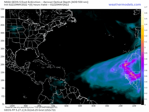
This current strong trade burst is expected to continue until about May 21, but afterwards trade winds are expected to weaken; we just need to see what happens with that.

*MDR SSTAs in May do not directly matter; a favorable pattern for May matters much less than an unfavorable pattern for September and vice-versa. However, the current pattern for May will influence how the pattern for September by virtue of the fact that the WAM consistently warms the MDR every summer by a certain amount; there are some years, such as 2018, in which the MDR was below-average during May, and the strong WAM was just barely enough to get the MDR above-average during September (by barely enough, I mean < 0.1 C above-average).
1 likes   


Return to “Talkin' Tropics”

Who is online

Users browsing this forum: CyclonicFury, Jagno, Stormybajan, zzzh and 62 guests