2022 Indicators (SSTs/SAL/MSLP/Shear/Steering/Instability) and >Day 16 Models
Moderator: S2k Moderators
Forum rules

The posts in this forum are NOT official forecasts and should not be used as such. They are just the opinion of the poster and may or may not be backed by sound meteorological data. They are NOT endorsed by any professional institution or STORM2K. For official information, please refer to products from the National Hurricane Center and National Weather Service.
-
SFLcane

- S2K Supporter

- Posts: 9606
- Age: 46
- Joined: Sat Jun 05, 2010 1:44 pm
- Location: Lake Worth Florida
Re: 2022 Indicators (SSTs/SAL/MSLP/Shear/Steering/Instability) and >Day 16 Models
One concern in my opinion is that we have the EURO + UKMET showing a strong +NAO this summer which could be a problem. +NAO = stronger ridging
4 likes
-
skyline385

- Category 5

- Posts: 2444
- Age: 33
- Joined: Wed Aug 26, 2020 11:15 pm
- Location: Palm Beach County FL
Re: 2022 Indicators (SSTs/SAL/MSLP/Shear/Steering/Instability) and >Day 16 Models
Got some crazy winds here today in SFL, its been 20-25 MPH throughout the day. The MDR could sure use some of these...
0 likes
-
AtlanticWind

- S2K Supporter
- Posts: 1805
- Age: 65
- Joined: Sun Aug 08, 2004 9:57 pm
- Location: Plantation,Fla
-
jasons2k

- Storm2k Executive

- Posts: 8076
- Age: 50
- Joined: Wed Jul 06, 2005 12:32 pm
- Location: The Woodlands, TX
Re: 2022 Indicators (SSTs/SAL/MSLP/Shear/Steering/Instability) and >Day 16 Models
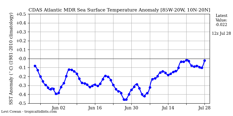
I was looking at the STT anomaly charts today and the GOM is well above normal now. The 30-day trend shows it warning even more and more too.
Looks like a very busy season ahead...
Looks like a very busy season ahead...
2 likes

Re: 2022 Indicators (SSTs/SAL/MSLP/Shear/Steering/Instability) and >Day 16 Models
jasons2k wrote:I was looking at the STT anomaly charts today and the GOM is well above normal now. The 30-day trend shows it warning even more and more too.
Looks like a very busy season ahead...
https://twitter.com/DCAreaWx/status/1524189391547256839
Gulf SSTA has little correlation with season
5 likes
Re: 2022 Indicators (SSTs/SAL/MSLP/Shear/Steering/Instability) and >Day 16 Models
The only thing 95% of y’all care about is the MDR. Most storms struggle there till late September. Season doesn’t really get going there till then.
3 likes
-
Blown Away

- S2K Supporter
- Posts: 9861
- Joined: Wed May 26, 2004 6:17 am
Re: 2022 Indicators (SSTs/SAL/MSLP/Shear/Steering/Instability) and >Day 16 Models
2022 1.08 1.68 0.77 -0.36
NAO turned negative for April.
0 likes
Hurricane Eye Experience: David 79, Irene 99, Frances 04, Jeanne 04, Wilma 05...
Hurricane Brush Experience: Andrew 92, Erin 95, Floyd 99, Matthew 16, Irma 17, Ian 22, Nicole 22…
Hurricane Brush Experience: Andrew 92, Erin 95, Floyd 99, Matthew 16, Irma 17, Ian 22, Nicole 22…
-
SFLcane
- S2K Supporter
- Posts: 9606
- Age: 46
- Joined: Sat Jun 05, 2010 1:44 pm
- Location: Lake Worth Florida
Re: 2022 Indicators (SSTs/SAL/MSLP/Shear/Steering/Instability) and >Day 16 Models
Found on youtube this morning it's pretty interesting. Video link below.
How will the Bermuda-Azores High Pressure system affect the 2022 Atlantic Hurricane Season?
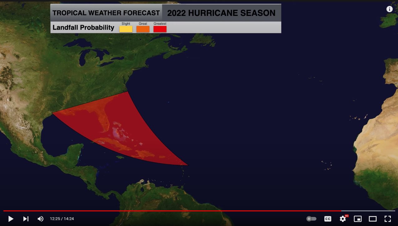
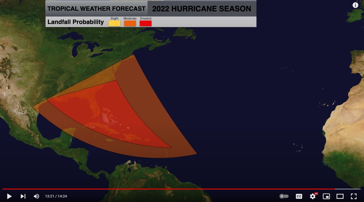
Link: https://youtu.be/j7RGIh4SCpE
How will the Bermuda-Azores High Pressure system affect the 2022 Atlantic Hurricane Season?
Link: https://youtu.be/j7RGIh4SCpE
2 likes
-
cycloneye

- Admin
- Posts: 139069
- Age: 67
- Joined: Thu Oct 10, 2002 10:54 am
- Location: San Juan, Puerto Rico
Re: 2022 Indicators (SSTs/SAL/MSLP/Shear/Steering/Instability) and >Day 16 Models
SFLcane wrote:Found on youtube this morning it's pretty interesting. Video link below.
How will the Bermuda-Azores High Pressure system affect the 2022 Atlantic Hurricane Season?
https://i.postimg.cc/qMgM9gPP/high.jpg
https://i.postimg.cc/HxLfV89H/high2.jpg
https://youtu.be/j7RGIh4SCpE
Analog 1956, year when came to this world on 8/11/56 and Betsy moved over PR one day later.
2 likes
Visit the Caribbean-Central America Weather Thread where you can find at first post web cams,radars
and observations from Caribbean basin members Click Here
and observations from Caribbean basin members Click Here
-
Category5Kaiju

- Category 5
- Posts: 3357
- Age: 22
- Joined: Thu Dec 24, 2020 12:45 pm
- Location: Seattle
Re: 2022 Indicators (SSTs/SAL/MSLP/Shear/Steering/Instability) and >Day 16 Models

Looks like the upcoming MDR trade surge will only last about a week or so, before the westerlies resume. You can see around the May 21st timeframe, where a wall of westerlies look to expand ever so slightly westward
1 likes
Unless explicitly stated, all information covered in my posts is based on my opinions and observations. Please refer to a professional meteorologist or an accredited weather research agency otherwise, especially if serious decisions must be made in the event of a potentially life-threatening tropical storm or hurricane.
-
cycloneye
- Admin
- Posts: 139069
- Age: 67
- Joined: Thu Oct 10, 2002 10:54 am
- Location: San Juan, Puerto Rico
Re: 2022 Indicators (SSTs/SAL/MSLP/Shear/Steering/Instability) and >Day 16 Models
1 likes
Visit the Caribbean-Central America Weather Thread where you can find at first post web cams,radars
and observations from Caribbean basin members Click Here
and observations from Caribbean basin members Click Here
-
NotSparta

- Professional-Met

- Posts: 1648
- Age: 22
- Joined: Fri Aug 18, 2017 8:24 am
- Location: Naples, FL
- Contact:
Re: 2022 Indicators (SSTs/SAL/MSLP/Shear/Steering/Instability) and >Day 16 Models
Cpv17 wrote:The only thing 95% of y’all care about is the MDR. Most storms struggle there till late September. Season doesn’t really get going there till then.
This is the seasonal indicators thread, so of course there will be focus on something that is typically a relatively strong seasonal indicator, especially when it is out of step with many of the others
7 likes
This post was probably an opinion of mine, and in no way is official. Please refer to http://www.hurricanes.gov for official tropical analysis and advisories.
My website, with lots of tropical wx graphics, including satellite and recon: http://cyclonicwx.com
My website, with lots of tropical wx graphics, including satellite and recon: http://cyclonicwx.com
Re: 2022 Indicators (SSTs/SAL/MSLP/Shear/Steering/Instability) and >Day 16 Models
NotSparta wrote:Cpv17 wrote:The only thing 95% of y’all care about is the MDR. Most storms struggle there till late September. Season doesn’t really get going there till then.
This is the seasonal indicators thread, so of course there will be focus on something that is typically a relatively strong seasonal indicator, especially when it is out of step with many of the others
A lot of people on here care about ACE. And how do you get a lot of ACE? By something forming in the MDR. I don’t even know why they call it the MDR? Storms for years now have mainly struggled in that area. The hotspots have been the western Caribbean, Gulf/BOC, the area around the Bahamas, and a lot of the western/central Atlantic.
0 likes
-
skyline385
- Category 5
- Posts: 2444
- Age: 33
- Joined: Wed Aug 26, 2020 11:15 pm
- Location: Palm Beach County FL
Re: 2022 Indicators (SSTs/SAL/MSLP/Shear/Steering/Instability) and >Day 16 Models
Cpv17 wrote:NotSparta wrote:Cpv17 wrote:The only thing 95% of y’all care about is the MDR. Most storms struggle there till late September. Season doesn’t really get going there till then.
This is the seasonal indicators thread, so of course there will be focus on something that is typically a relatively strong seasonal indicator, especially when it is out of step with many of the others
A lot of people on here care about ACE. And how do you get a lot of ACE? By something forming in the MDR. I don’t even know why they call it the MDR? Storms for years now have mainly struggled in that area. The hotspots have been the western Caribbean, Gulf/BOC, the area around the Bahamas, and a lot of the western/central Atlantic.
Think this post answers your question very well
zzh wrote:jasons2k wrote:I was looking at the STT anomaly charts today and the GOM is well above normal now. The 30-day trend shows it warning even more and more too.
Looks like a very busy season ahead...
https://twitter.com/DCAreaWx/status/1524189391547256839
Gulf SSTA has little correlation with season
0 likes
Re: 2022 Indicators (SSTs/SAL/MSLP/Shear/Steering/Instability) and >Day 16 Models
Cpv17 wrote:NotSparta wrote:Cpv17 wrote:The only thing 95% of y’all care about is the MDR. Most storms struggle there till late September. Season doesn’t really get going there till then.
This is the seasonal indicators thread, so of course there will be focus on something that is typically a relatively strong seasonal indicator, especially when it is out of step with many of the others
A lot of people on here care about ACE. And how do you get a lot of ACE? By something forming in the MDR. I don’t even know why they call it the MDR? Storms for years now have mainly struggled in that area. The hotspots have been the western Caribbean, Gulf/BOC, the area around the Bahamas, and a lot of the western/central Atlantic.
It is called MDR because of climatology. About 70% of Atlantic TCs pass through the MDR at some point in their life. Subtropical warm pool makes storms struggle there in recent years.
1 likes
-
skyline385
- Category 5
- Posts: 2444
- Age: 33
- Joined: Wed Aug 26, 2020 11:15 pm
- Location: Palm Beach County FL
-
cycloneye
- Admin
- Posts: 139069
- Age: 67
- Joined: Thu Oct 10, 2002 10:54 am
- Location: San Juan, Puerto Rico
Re: 2022 Indicators (SSTs/SAL/MSLP/Shear/Steering/Instability) and >Day 16 Models
160 ACE is the goal.
https://twitter.com/cyclonicwx/status/1525107084848680960
https://twitter.com/dmorris9661/status/1525123425911681025
https://twitter.com/cyclonicwx/status/1525107084848680960
https://twitter.com/dmorris9661/status/1525123425911681025
0 likes
Visit the Caribbean-Central America Weather Thread where you can find at first post web cams,radars
and observations from Caribbean basin members Click Here
and observations from Caribbean basin members Click Here
-
toad strangler

- S2K Supporter
- Posts: 4162
- Joined: Sun Jul 28, 2013 3:09 pm
- Location: Earth
- Contact:
Re: 2022 Indicators (SSTs/SAL/MSLP/Shear/Steering/Instability) and >Day 16 Models
SFLcane wrote:Found on youtube this morning it's pretty interesting. Video link below.
How will the Bermuda-Azores High Pressure system affect the 2022 Atlantic Hurricane Season?
https://i.postimg.cc/qMgM9gPP/high.jpg
https://i.postimg.cc/HxLfV89H/high2.jpg
https://youtu.be/j7RGIh4SCpE
This guy is another one who mis reads the NOAA return rate maps as landfalls when in actuality they represent the return of a storms center within 50 nautical miles of a location. Huge difference.
1 likes
-
SFLcane
- S2K Supporter
- Posts: 9606
- Age: 46
- Joined: Sat Jun 05, 2010 1:44 pm
- Location: Lake Worth Florida
Re: 2022 Indicators (SSTs/SAL/MSLP/Shear/Steering/Instability) and >Day 16 Models
toad strangler wrote:SFLcane wrote:Found on youtube this morning it's pretty interesting. Video link below.
How will the Bermuda-Azores High Pressure system affect the 2022 Atlantic Hurricane Season?
https://i.postimg.cc/qMgM9gPP/high.jpg
https://i.postimg.cc/HxLfV89H/high2.jpg
https://youtu.be/j7RGIh4SCpE
This guy is another one who mis reads the NOAA return rate maps as landfalls when in actuality they represent the return of a storms center within 50 nautical miles of a location. Huge difference.
Return rates? What is that? South Florida does not follow that at all as of late infact last time the eastcoast saw a big hurricane was i can't even remember maybe 2 decades ago. I for one think something large scale has changed maybe climate change which allows us to continue dodging storms on a yearly bases. We surely are not the hurricane capitol anymore. Who knows anymore
0 likes
-
tolakram
- Admin
- Posts: 19165
- Age: 60
- Joined: Sun Aug 27, 2006 8:23 pm
- Location: Florence, KY (name is Mark)
Re: 2022 Indicators (SSTs/SAL/MSLP/Shear/Steering/Instability) and >Day 16 Models
SFLcane wrote:toad strangler wrote:SFLcane wrote:Found on youtube this morning it's pretty interesting. Video link below.
How will the Bermuda-Azores High Pressure system affect the 2022 Atlantic Hurricane Season?
https://i.postimg.cc/qMgM9gPP/high.jpg
https://i.postimg.cc/HxLfV89H/high2.jpg
https://youtu.be/j7RGIh4SCpE
This guy is another one who mis reads the NOAA return rate maps as landfalls when in actuality they represent the return of a storms center within 50 nautical miles of a location. Huge difference.
Return rates? What is that? South Florida does not follow that at all as of late infact last time the eastcoast saw a big hurricane was i can't even remember maybe 2 decades ago. I for one think something large scale has changed maybe climate change which allows us to continue dodging storms on a yearly bases. We surely are not the hurricane capitol anymore. Who knows anymore
Those return rates include hurricanes that never made actual landfall. They always have. If they were close enough NOAA considers them to be impacts. It's that same criteria that makes Florida the 'hurricane capital'.
0 likes
M a r k
- - - - -
Join us in chat: Storm2K Chatroom Invite. Android and IOS apps also available.
The posts in this forum are NOT official forecasts and should not be used as such. Posts are NOT endorsed by any professional institution or STORM2K.org. For official information and forecasts, please refer to NHC and NWS products.
Who is online
Users browsing this forum: cheezyWXguy, Lizzytiz1, ouragans, Stormybajan, tolakram and 199 guests