2022 Indicators (SSTs/SAL/MSLP/Shear/Steering/Instability) and >Day 16 Models

This is the general tropical discussion area. Anyone can take their shot at predicting a storms path.

Moderator: S2k Moderators

Forum rules

The posts in this forum are NOT official forecasts and should not be used as such. They are just the opinion of the poster and may or may not be backed by sound meteorological data. They are NOT endorsed by any professional institution or STORM2K. For official information, please refer to products from the National Hurricane Center and National Weather Service.

Help Support Storm2K
Message
Author
User avatar
gatorcane
S2K Supporter
S2K Supporter
Posts: 23499
Age: 46
Joined: Sun Mar 13, 2005 3:54 pm
Location: Boca Raton, FL

Re: 2022 Indicators (SSTs/SAL/MSLP/Shear/Steering/Instability) and >Day 16 Models

#1281 Postby gatorcane » Sun Jun 19, 2022 9:06 pm

Interesting snippet from NWS Key West discussion this evening at 921 PM EDT Sun Jun 19 2022:

An interesting side note. June averaged daily temperatures have
been running over 2 degrees F below normal. Of course, PTC one
traversed the Keys earlier in the month, but temps have been below
normal so far even taking that into account. The reason?
Convection and cloud cover have been more abundant so far than a
typical June, mainly because the typical June pattern of the
western Atlantic ridge building over the Peninsula has not taken
place in earnest. Migratory troughs along the Eastern Seaboard
have helped keep the axis of the Atlantic shunted south and east
of the Keys.
Of course, there are a few weeks of June left, but
the extended model guidance still does not show the ridge building
into a more climatological position


https://forecast.weather.gov/product.ph ... glossary=0

Wonder if this is an indicator in any way of the steering pattern for when Cape Verde season starts.
3 likes   

User avatar
skyline385
Category 5
Category 5
Posts: 2444
Age: 33
Joined: Wed Aug 26, 2020 11:15 pm
Location: Palm Beach County FL

Re: 2022 Indicators (SSTs/SAL/MSLP/Shear/Steering/Instability) and >Day 16 Models

#1282 Postby skyline385 » Sun Jun 19, 2022 9:18 pm

gatorcane wrote:Interesting snippet from NWS Key West discussion this evening at 921 PM EDT Sun Jun 19 2022:

An interesting side note. June averaged daily temperatures have
been running over 2 degrees F below normal. Of course, PTC one
traversed the Keys earlier in the month, but temps have been below
normal so far even taking that into account. The reason?
Convection and cloud cover have been more abundant so far than a
typical June, mainly because the typical June pattern of the
western Atlantic ridge building over the Peninsula has not taken
place in earnest. Migratory troughs along the Eastern Seaboard
have helped keep the axis of the Atlantic shunted south and east
of the Keys.
Of course, there are a few weeks of June left, but
the extended model guidance still does not show the ridge building
into a more climatological position


https://forecast.weather.gov/product.ph ... glossary=0

Wonder if this is an indicator in any way of the steering pattern for when Cape Verde season starts.


Webb posted this little analysis of the C3S ensembles where he talks about the ridge being further out this year.

 https://twitter.com/webberweather/status/1536875899118755840


0 likes   

User avatar
InfernoFlameCat
Category 5
Category 5
Posts: 1966
Age: 21
Joined: Mon Dec 14, 2020 10:52 am
Location: Buford, GA

Re: 2022 Indicators (SSTs/SAL/MSLP/Shear/Steering/Instability) and >Day 16 Models

#1283 Postby InfernoFlameCat » Sun Jun 19, 2022 9:35 pm

ScottNAtlanta wrote:That wave that just came off doesn't have a lot of convection, but there is a definite low level spin in the clouds. If it starts popping some convection in the next couple of days the only thing holding it back would be the large envelope

Yeah but no convection will pop off with it. Even near peak season these waves struggle to produce convection after moving off the African coast. Too much dry, stable air.
0 likes   
I am by no means a professional. DO NOT look at my forecasts for official information or make decisions based on what I post.

Goal: to become a registered expert over tropical and subtropical cyclones.

User avatar
cycloneye
Admin
Admin
Posts: 139028
Age: 67
Joined: Thu Oct 10, 2002 10:54 am
Location: San Juan, Puerto Rico

Re: 2022 Indicators (SSTs/SAL/MSLP/Shear/Steering/Instability) and >Day 16 Models

#1284 Postby cycloneye » Mon Jun 20, 2022 8:04 am

Here is the MIMIC-TPW showing some juiced atmosphere with area of low pressure near Cabo Verde Islands not analized as a wave yet. That helps to reduce the SAL.

Image

Image
3 likes   
Visit the Caribbean-Central America Weather Thread where you can find at first post web cams,radars
and observations from Caribbean basin members Click Here

User avatar
kevin
Category 5
Category 5
Posts: 1767
Age: 25
Joined: Wed Aug 28, 2019 4:35 am

Re: 2022 Indicators (SSTs/SAL/MSLP/Shear/Steering/Instability) and >Day 16 Models

#1285 Postby kevin » Mon Jun 20, 2022 10:55 am

In the last 12 days the Atlantic has become increasingly favorable for hurricane formation. As far as I know this map is (mostly) based on temperature so shear will most likely still limit formation of strong hurricanes for a while. But the evolution towards a more favorable basin is clear. The warming is most evident in the GOM and the MDR.

June 8

Image

June 20

Image
Last edited by kevin on Mon Jun 20, 2022 11:09 am, edited 2 times in total.
3 likes   

User avatar
kevin
Category 5
Category 5
Posts: 1767
Age: 25
Joined: Wed Aug 28, 2019 4:35 am

Re: 2022 Indicators (SSTs/SAL/MSLP/Shear/Steering/Instability) and >Day 16 Models

#1286 Postby kevin » Mon Jun 20, 2022 10:58 am

Also here's a comparison with the hurricane potential on June 22, 2020.

June 22, 2020

Image

June 20, 2022

Image
3 likes   

User avatar
NotSparta
Professional-Met
Professional-Met
Posts: 1645
Age: 22
Joined: Fri Aug 18, 2017 8:24 am
Location: Naples, FL
Contact:

Re: 2022 Indicators (SSTs/SAL/MSLP/Shear/Steering/Instability) and >Day 16 Models

#1287 Postby NotSparta » Mon Jun 20, 2022 11:06 am

kevin wrote:In the last 12 days the Atlantic has become increasinly favorable for hurricane formation. As far as I know this map is (mostly) based on temperature so shear will most likely still limit formation of strong hurricanes for a while. But the evolution towards a more favorable basin is clear. The warming is most evident in the GOM and the MDR.

June 8

https://i.imgur.com/vTfXkr5.png

June 20

https://i.imgur.com/r97luKt.png


The ocean is warming during June, more at 11
5 likes   
This post was probably an opinion of mine, and in no way is official. Please refer to http://www.hurricanes.gov for official tropical analysis and advisories.

My website, with lots of tropical wx graphics, including satellite and recon: http://cyclonicwx.com

User avatar
kevin
Category 5
Category 5
Posts: 1767
Age: 25
Joined: Wed Aug 28, 2019 4:35 am

Re: 2022 Indicators (SSTs/SAL/MSLP/Shear/Steering/Instability) and >Day 16 Models

#1288 Postby kevin » Mon Jun 20, 2022 11:11 am

NotSparta wrote:
kevin wrote:In the last 12 days the Atlantic has become increasinly favorable for hurricane formation. As far as I know this map is (mostly) based on temperature so shear will most likely still limit formation of strong hurricanes for a while. But the evolution towards a more favorable basin is clear. The warming is most evident in the GOM and the MDR.

June 8

https://i.imgur.com/vTfXkr5.png

June 20

https://i.imgur.com/r97luKt.png


The ocean is warming during June, more at 11


Haha I get what you mean :lol: , I know warming of the oceans during June is the same as saying that water is wet. It's more about the speed at which it happening (or at least seems to be happening in these MPI images) compared to previous years. I guess the image from 2020 in the post afterwards is a bit better to put it into context.
2 likes   

User avatar
skyline385
Category 5
Category 5
Posts: 2444
Age: 33
Joined: Wed Aug 26, 2020 11:15 pm
Location: Palm Beach County FL

Re: 2022 Indicators (SSTs/SAL/MSLP/Shear/Steering/Instability) and >Day 16 Models

#1289 Postby skyline385 » Mon Jun 20, 2022 11:37 am

While the Gulf SST are highly variable and not directly related to seasonal ACE, we seem to be running much ahead of previous seasons (including 2020 & 2005) because of the heat. And then there is the strong loop current prevailing this year. Not going to end up pretty for any system entering the Gulf if this continues.

 https://twitter.com/DrKimWood/status/1538886318746480640


Image
Image
3 likes   

User avatar
Category5Kaiju
Category 5
Category 5
Posts: 3351
Age: 22
Joined: Thu Dec 24, 2020 12:45 pm
Location: Seattle

Re: 2022 Indicators (SSTs/SAL/MSLP/Shear/Steering/Instability) and >Day 16 Models

#1290 Postby Category5Kaiju » Mon Jun 20, 2022 1:07 pm

skyline385 wrote:While the Gulf SST are highly variable and not directly related to seasonal ACE, we seem to be running much ahead of previous seasons (including 2020 & 2005) because of the heat. And then there is the strong loop current prevailing this year. Not going to end up pretty for any system entering the Gulf if this continues.

https://twitter.com/DrKimWood/status/1538886318746480640
https://i.imgur.com/haDyByB.png
https://i.imgur.com/1Kkdfye.png


Ok, this has got to be the most anomalously warm Loop Current recorded since at least 1995. For us to be even ahead of years like 2005 or 2020, I of course hope that nothing later this season comes along and takes advantage of that (shear and dry air aside).
0 likes   
Unless explicitly stated, all information covered in my posts is based on my opinions and observations. Please refer to a professional meteorologist or an accredited weather research agency otherwise, especially if serious decisions must be made in the event of a potentially life-threatening tropical storm or hurricane.

User avatar
cycloneye
Admin
Admin
Posts: 139028
Age: 67
Joined: Thu Oct 10, 2002 10:54 am
Location: San Juan, Puerto Rico

Re: 2022 Indicators (SSTs/SAL/MSLP/Shear/Steering/Instability) and >Day 16 Models

#1291 Postby cycloneye » Mon Jun 20, 2022 7:29 pm

6 likes   
Visit the Caribbean-Central America Weather Thread where you can find at first post web cams,radars
and observations from Caribbean basin members Click Here

User avatar
SFLcane
S2K Supporter
S2K Supporter
Posts: 9606
Age: 46
Joined: Sat Jun 05, 2010 1:44 pm
Location: Lake Worth Florida

Re: 2022 Indicators (SSTs/SAL/MSLP/Shear/Steering/Instability) and >Day 16 Models

#1292 Postby SFLcane » Tue Jun 21, 2022 8:52 am

1 likes   

User avatar
cycloneye
Admin
Admin
Posts: 139028
Age: 67
Joined: Thu Oct 10, 2002 10:54 am
Location: San Juan, Puerto Rico

Re: 2022 Indicators (SSTs/SAL/MSLP/Shear/Steering/Instability) and >Day 16 Models

#1293 Postby cycloneye » Tue Jun 21, 2022 8:59 am

6 likes   
Visit the Caribbean-Central America Weather Thread where you can find at first post web cams,radars
and observations from Caribbean basin members Click Here

User avatar
SFLcane
S2K Supporter
S2K Supporter
Posts: 9606
Age: 46
Joined: Sat Jun 05, 2010 1:44 pm
Location: Lake Worth Florida

Re: 2022 Indicators (SSTs/SAL/MSLP/Shear/Steering/Instability) and >Day 16 Models

#1294 Postby SFLcane » Tue Jun 21, 2022 6:47 pm

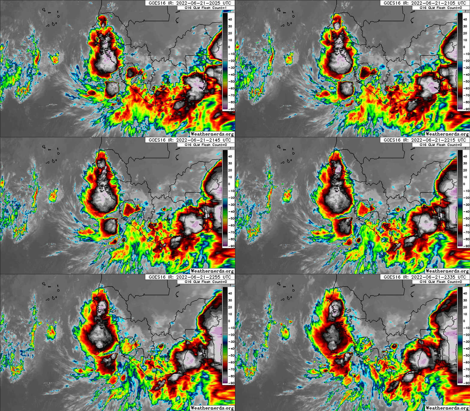
Say what you want but this is quite the impressive wave for mid June.

Image
4 likes   

Cpv17
Category 5
Category 5
Posts: 4313
Joined: Wed Dec 07, 2016 2:24 pm
Location: Wharton/El Campo, TX

Re: 2022 Indicators (SSTs/SAL/MSLP/Shear/Steering/Instability) and >Day 16 Models

#1295 Postby Cpv17 » Tue Jun 21, 2022 7:05 pm

How is SAL and wind shear currently looking?
0 likes   

User avatar
Category5Kaiju
Category 5
Category 5
Posts: 3351
Age: 22
Joined: Thu Dec 24, 2020 12:45 pm
Location: Seattle

Re: 2022 Indicators (SSTs/SAL/MSLP/Shear/Steering/Instability) and >Day 16 Models

#1296 Postby Category5Kaiju » Wed Jun 22, 2022 1:14 am

Image

Ngl, just by purely looking at how it looks, the wave that these models seem keen on looks pretty darn good. As in, if it were September, it looks like what a precursor for a monster hurricane would look like. Now of course, it is still June, and climatology is obviously on our side. However, it is still a bit nerve-wracking to say the least to think that it's only June and we are already seeing some badass waves, which imho is a harbinger of what may come later this season. :cry:
6 likes   
Unless explicitly stated, all information covered in my posts is based on my opinions and observations. Please refer to a professional meteorologist or an accredited weather research agency otherwise, especially if serious decisions must be made in the event of a potentially life-threatening tropical storm or hurricane.

User avatar
weeniepatrol
Category 3
Category 3
Posts: 857
Joined: Sat Aug 22, 2020 5:30 pm
Location: WA State

Re: 2022 Indicators (SSTs/SAL/MSLP/Shear/Steering/Instability) and >Day 16 Models

#1297 Postby weeniepatrol » Wed Jun 22, 2022 3:34 am

Category5Kaiju wrote:https://i.imgur.com/kEbcJXz.png


Yeah, that’s a yikes from me. I already long for the days of 2018-19 when the whole mdr was a moistureless dust-laden graveyard. Strap in every one… I think we are in for a serious ride
6 likes   

User avatar
weeniepatrol
Category 3
Category 3
Posts: 857
Joined: Sat Aug 22, 2020 5:30 pm
Location: WA State

Re: 2022 Indicators (SSTs/SAL/MSLP/Shear/Steering/Instability) and >Day 16 Models

#1298 Postby weeniepatrol » Wed Jun 22, 2022 3:36 am

Whatever you do DON’T look at the 0z eps unless you’ve got some fresh boxers to change into!
2 likes   

User avatar
toad strangler
S2K Supporter
S2K Supporter
Posts: 4162
Joined: Sun Jul 28, 2013 3:09 pm
Location: Earth
Contact:

Re: 2022 Indicators (SSTs/SAL/MSLP/Shear/Steering/Instability) and >Day 16 Models

#1299 Postby toad strangler » Wed Jun 22, 2022 6:21 am

weeniepatrol wrote:
Category5Kaiju wrote:https://i.imgur.com/kEbcJXz.png


Yeah, that’s a yikes from me. I already long for the days of 2018-19 when the whole mdr was a moistureless dust-laden graveyard. Strap in every one… I think we are in for a serious ride


:eek:
0 likes   

User avatar
InfernoFlameCat
Category 5
Category 5
Posts: 1966
Age: 21
Joined: Mon Dec 14, 2020 10:52 am
Location: Buford, GA

Re: 2022 Indicators (SSTs/SAL/MSLP/Shear/Steering/Instability) and >Day 16 Models

#1300 Postby InfernoFlameCat » Wed Jun 22, 2022 6:36 am

Remember, the African monsoon peaks twice, once in June, and second through classic Cape Verde season, which is from late July to late September. So we do see vigorous waves in June.
1 likes   
I am by no means a professional. DO NOT look at my forecasts for official information or make decisions based on what I post.

Goal: to become a registered expert over tropical and subtropical cyclones.


Return to “Talkin' Tropics”

Who is online

Users browsing this forum: shah83 and 139 guests