2022 Indicators (SSTs/SAL/MSLP/Shear/Steering/Instability) and >Day 16 Models

This is the general tropical discussion area. Anyone can take their shot at predicting a storms path.

Moderator: S2k Moderators

Forum rules

The posts in this forum are NOT official forecasts and should not be used as such. They are just the opinion of the poster and may or may not be backed by sound meteorological data. They are NOT endorsed by any professional institution or STORM2K. For official information, please refer to products from the National Hurricane Center and National Weather Service.

Help Support Storm2K
Message
Author
User avatar
Category5Kaiju
Category 5
Category 5
Posts: 3357
Age: 22
Joined: Thu Dec 24, 2020 12:45 pm
Location: Seattle

Re: 2022 indicators: SSTs / SAL / MSLP / shear / steering / instability / images

#81 Postby Category5Kaiju » Wed Feb 09, 2022 3:59 pm

Image

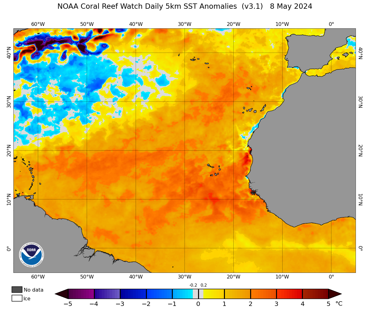
Is it early? Of course? Is this alarming for this part of the year? Well, considering most of the recent years started as -AMO and shifted to +AMO, this is indeed a new look for the Atlantic in February, with a slight but nevertheless +AMO. Oh, and the MDR sst anomalies. If we had this general look persist or strengthen going forward, then that's definitely something we must really start paying attention to.
0 likes   
Unless explicitly stated, all information covered in my posts is based on my opinions and observations. Please refer to a professional meteorologist or an accredited weather research agency otherwise, especially if serious decisions must be made in the event of a potentially life-threatening tropical storm or hurricane.

User avatar
cycloneye
Admin
Admin
Posts: 139080
Age: 67
Joined: Thu Oct 10, 2002 10:54 am
Location: San Juan, Puerto Rico

Re: 2022 indicators: SSTs / SAL / MSLP / shear / steering / instability / images

#82 Postby cycloneye » Wed Feb 09, 2022 5:54 pm

0 likes   
Visit the Caribbean-Central America Weather Thread where you can find at first post web cams,radars
and observations from Caribbean basin members Click Here

AlphaToOmega
Category 5
Category 5
Posts: 1448
Joined: Sat Jun 26, 2021 10:51 am
Location: Somewhere in Massachusetts

Re: 2022 indicators: SSTs / SAL / MSLP / shear / steering / instability / images

#83 Postby AlphaToOmega » Wed Feb 09, 2022 7:13 pm

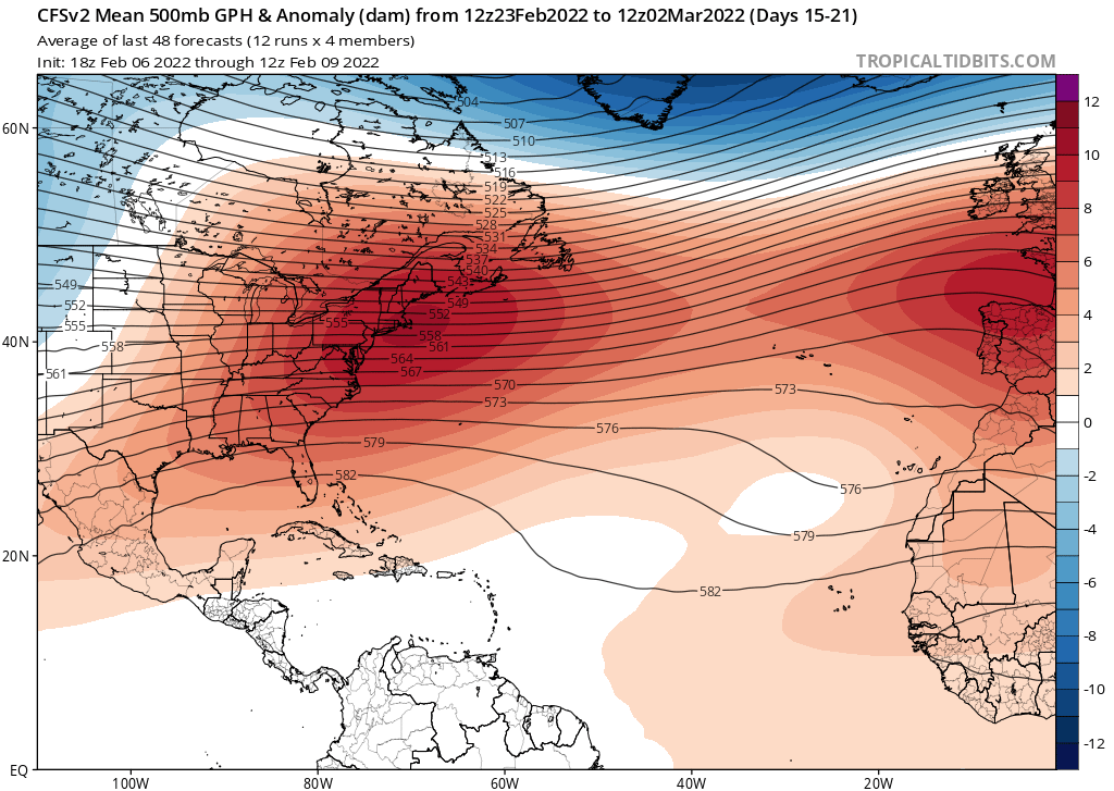
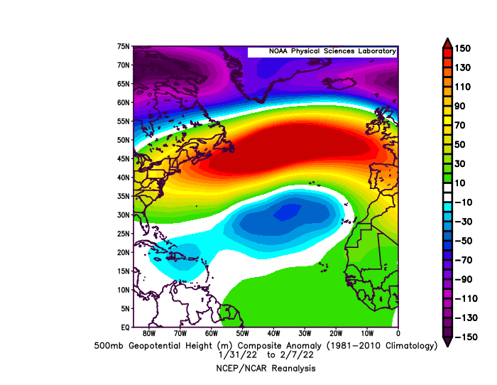
You can thank this pattern for the SSTA maps we are seeing right now:
Image

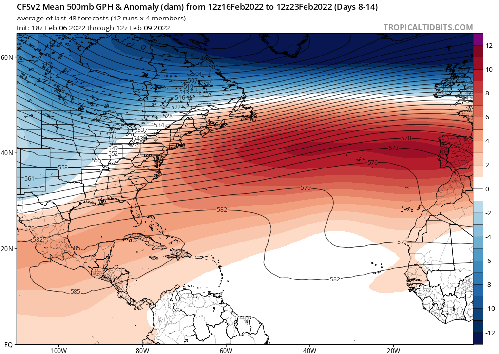
If that pattern persists, we could see an MDR that remains strongly above-average. It seems like that height anomaly pattern is not forecast to persist, so there might be some MDR cooling in the next couple of months.
Image
Image
1 likes   

User avatar
NotSparta
Professional-Met
Professional-Met
Posts: 1648
Age: 22
Joined: Fri Aug 18, 2017 8:24 am
Location: Naples, FL
Contact:

Re: 2022 indicators: SSTs / SAL / MSLP / shear / steering / instability / images

#84 Postby NotSparta » Wed Feb 09, 2022 7:26 pm

Category5Kaiju wrote:https://coralreefwatch.noaa.gov/data_current/5km/v3.1_op/daily/png/ct5km_ssta_v3.1_nwel_current.png

Is it early? Of course? Is this alarming for this part of the year? Well, considering most of the recent years started as -AMO and shifted to +AMO, this is indeed a new look for the Atlantic in February, with a slight but nevertheless +AMO. Oh, and the MDR sst anomalies. If we had this general look persist or strengthen going forward, then that's definitely something we must really start paying attention to.


The good news is there will probably be a trade burst soon as high pressure sets in. Should cool from here but how much is up in the air
1 likes   
This post was probably an opinion of mine, and in no way is official. Please refer to http://www.hurricanes.gov for official tropical analysis and advisories.

My website, with lots of tropical wx graphics, including satellite and recon: http://cyclonicwx.com

Shell Mound
Category 5
Category 5
Posts: 2434
Age: 31
Joined: Thu Sep 07, 2017 3:39 pm
Location: St. Petersburg, FL → Scandinavia

Re: 2022 indicators: SSTs / SAL / MSLP / shear / steering / instability / images

#85 Postby Shell Mound » Thu Feb 10, 2022 4:46 am

NotSparta wrote:
Category5Kaiju wrote:https://coralreefwatch.noaa.gov/data_current/5km/v3.1_op/daily/png/ct5km_ssta_v3.1_nwel_current.png

Is it early? Of course? Is this alarming for this part of the year? Well, considering most of the recent years started as -AMO and shifted to +AMO, this is indeed a new look for the Atlantic in February, with a slight but nevertheless +AMO. Oh, and the MDR sst anomalies. If we had this general look persist or strengthen going forward, then that's definitely something we must really start paying attention to.

The good news is there will probably be a trade burst soon as high pressure sets in. Should cool from here but how much is up in the air

One can already see the reemergence of the late-winter -AMM with the recent cooling south of Greenland, so this year is still resembling recent winters’ evolution.
0 likes   
CVW / MiamiensisWx / Shell Mound
The posts in this forum are NOT official forecasts and should not be used as such. They are just the opinion of the poster and may or may not be backed by sound meteorological data. They are NOT endorsed by any professional institution or STORM2K. For official information, please refer to products from the NHC and NWS.

User avatar
SFLcane
S2K Supporter
S2K Supporter
Posts: 9606
Age: 46
Joined: Sat Jun 05, 2010 1:44 pm
Location: Lake Worth Florida

Re: 2022 indicators: SSTs / SAL / MSLP / shear / steering / instability / images

#86 Postby SFLcane » Thu Feb 10, 2022 9:13 am

El Niño is just not happening folks..

 https://twitter.com/andyhazelton/status/1491776845301301248


2 likes   

User avatar
SFLcane
S2K Supporter
S2K Supporter
Posts: 9606
Age: 46
Joined: Sat Jun 05, 2010 1:44 pm
Location: Lake Worth Florida

Re: 2022 indicators: SSTs / SAL / MSLP / shear / steering / instability / images

#87 Postby SFLcane » Thu Feb 10, 2022 9:18 am

Category5Kaiju wrote:https://coralreefwatch.noaa.gov/data_current/5km/v3.1_op/daily/png/ct5km_ssta_v3.1_nwel_current.png

Is it early? Of course? Is this alarming for this part of the year? Well, considering most of the recent years started as -AMO and shifted to +AMO, this is indeed a new look for the Atlantic in February, with a slight but nevertheless +AMO. Oh, and the MDR sst anomalies. If we had this general look persist or strengthen going forward, then that's definitely something we must really start paying attention to.

For our sake let’s hope that pattern changes and it doesn’t look anything like this in April.
0 likes   

User avatar
cycloneye
Admin
Admin
Posts: 139080
Age: 67
Joined: Thu Oct 10, 2002 10:54 am
Location: San Juan, Puerto Rico

Re: 2022 indicators: SSTs / SAL / MSLP / shear / steering / instability / images

#88 Postby cycloneye » Thu Feb 10, 2022 9:26 am

SFLcane wrote:El Niño is just not happening folks..

https://twitter.com/andyhazelton/status/1491776845301301248?


That was for the ENSO updates thread but I posted the CPC update there. :D
1 likes   
Visit the Caribbean-Central America Weather Thread where you can find at first post web cams,radars
and observations from Caribbean basin members Click Here

User avatar
NotSparta
Professional-Met
Professional-Met
Posts: 1648
Age: 22
Joined: Fri Aug 18, 2017 8:24 am
Location: Naples, FL
Contact:

Re: 2022 indicators: SSTs / SAL / MSLP / shear / steering / instability / images

#89 Postby NotSparta » Thu Feb 10, 2022 9:41 am

Shell Mound wrote:
NotSparta wrote:
Category5Kaiju wrote:https://coralreefwatch.noaa.gov/data_current/5km/v3.1_op/daily/png/ct5km_ssta_v3.1_nwel_current.png

Is it early? Of course? Is this alarming for this part of the year? Well, considering most of the recent years started as -AMO and shifted to +AMO, this is indeed a new look for the Atlantic in February, with a slight but nevertheless +AMO. Oh, and the MDR sst anomalies. If we had this general look persist or strengthen going forward, then that's definitely something we must really start paying attention to.
The good news is there will probably be a trade burst soon as high pressure sets in. Should cool from here but how much is up in the air

One can already see the reemergence of the late-winter -AMO with the recent cooling south of Greenland, so this year is still resembling recent winters’ evolution.


True, but that hasn't been all that relevant lately. Seems it's really more up to if the MDR is warm even if around Greenland is cold. Connection through +NAO can still help cool it off though
1 likes   
This post was probably an opinion of mine, and in no way is official. Please refer to http://www.hurricanes.gov for official tropical analysis and advisories.

My website, with lots of tropical wx graphics, including satellite and recon: http://cyclonicwx.com

Shell Mound
Category 5
Category 5
Posts: 2434
Age: 31
Joined: Thu Sep 07, 2017 3:39 pm
Location: St. Petersburg, FL → Scandinavia

Re: 2022 indicators: SSTs / SAL / MSLP / shear / steering / instability / images

#90 Postby Shell Mound » Thu Feb 10, 2022 10:26 am

NotSparta wrote:
Shell Mound wrote:
NotSparta wrote:The good news is there will probably be a trade burst soon as high pressure sets in. Should cool from here but how much is up in the air

One can already see the reemergence of the late-winter -AMO with the recent cooling south of Greenland, so this year is still resembling recent winters’ evolution.


True, but that hasn't been all that relevant lately. Seems it's really more up to if the MDR is warm even if around Greenland is cold. Connection through +NAO can still help cool it off though

I still think that the cool SST near Greenland helps suppress high-ACE activity in the MDR, even if SSTs are otherwise above average in the deep tropics. Most of the seasons since 2013 have a) exhibited cooler-than-average SST near Greenland and b) tended to feature lower ACE in the MDR than was previously observed during the period of 1995–2012. 2017 and 2021 were exceptional in that both years featured multiple long-tracked majors in the MDR, but none of the other years since 2016 has featured more than one long-lived MH in the MDR. Getting multiple majors in the MDR in 2022 will be difficult, even with +SST present, unless the area near Greenland can warm significantly. I think that this season will be another slightly-above-average season due to the relatively warmer subtropics and far North Atlantic vs. the deep tropics competing with neutral ENSO, lingering -PDO, and the ASW. Stability and the TUTT will continue to limit the potential for significant ACE in the deep tropics.
0 likes   
CVW / MiamiensisWx / Shell Mound
The posts in this forum are NOT official forecasts and should not be used as such. They are just the opinion of the poster and may or may not be backed by sound meteorological data. They are NOT endorsed by any professional institution or STORM2K. For official information, please refer to products from the NHC and NWS.

User avatar
WiscoWx02
Category 1
Category 1
Posts: 340
Age: 21
Joined: Sat Jul 31, 2021 8:09 pm
Location: Minnesota

Re: 2022 indicators: SSTs / SAL / MSLP / shear / steering / instability / images

#91 Postby WiscoWx02 » Thu Feb 10, 2022 12:07 pm

Shell Mound wrote:
NotSparta wrote:
Shell Mound wrote:One can already see the reemergence of the late-winter -AMO with the recent cooling south of Greenland, so this year is still resembling recent winters’ evolution.


True, but that hasn't been all that relevant lately. Seems it's really more up to if the MDR is warm even if around Greenland is cold. Connection through +NAO can still help cool it off though

I still think that the cool SST near Greenland helps suppress high-ACE activity in the MDR, even if SSTs are otherwise above average in the deep tropics. Most of the seasons since 2013 have a) exhibited cooler-than-average SST near Greenland and b) tended to feature lower ACE in the MDR than was previously observed during the period of 1995–2012. 2017 and 2021 were exceptional in that both years featured multiple long-tracked majors in the MDR, but none of the other years since 2016 has featured more than one long-lived MH in the MDR. Getting multiple majors in the MDR in 2022 will be difficult, even with +SST present, unless the area near Greenland can warm significantly. I think that this season will be another slightly-above-average season due to the relatively warmer subtropics and far North Atlantic vs. the deep tropics competing with neutral ENSO, lingering -PDO, and the ASW. Stability and the TUTT will continue to limit the potential for significant ACE in the deep tropics.


I'm not entirely sure about the validity of the Greenland warmth argument looking at past SSTA data, however, if your saying we haven't been in a proper +AMO since 2013 I'd agree with you on that. We've been caught in this limbo between a positive and negative AMO for the last several years, which is why I do not expect this warm look in the Atlantic to last as others do as well given the projected patterns by the models. I don't think a full blown -AMO is likely either though since the MDR was much colder by this time in 2018 when we had the full blown -AMO emerge for a little while. I will 100% agree that TUTT's and stability are going to be an issue as long as the subtropics remain anomalously warm which given our climate situation that might not be going anywhere any time soon.
1 likes   

AlphaToOmega
Category 5
Category 5
Posts: 1448
Joined: Sat Jun 26, 2021 10:51 am
Location: Somewhere in Massachusetts

Re: 2022 indicators: SSTs / SAL / MSLP / shear / steering / instability / images

#92 Postby AlphaToOmega » Thu Feb 10, 2022 4:05 pm

SSTAs right now are meaningless for this hurricane season, for we are still in the 2021-2022 winter. The best tools we have are climate models, which have their issues. The CFSv2 tends to have a bias towards -AMM (especially months before hurricane season); the ECMWF also tends to have a bias towards -AMM, but it also has a +ENSO bias. Even though we are in the dark with many details, there is something we basically know for certain: +AMO. The AMO has never been negative during ASO from 1997 to 2021, and it appears as if that trend will continue.
2 likes   

AlphaToOmega
Category 5
Category 5
Posts: 1448
Joined: Sat Jun 26, 2021 10:51 am
Location: Somewhere in Massachusetts

Re: 2022 indicators: SSTs / SAL / MSLP / shear / steering / instability / images

#93 Postby AlphaToOmega » Fri Feb 11, 2022 7:50 pm

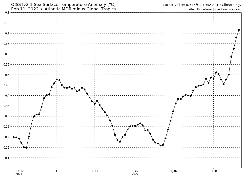
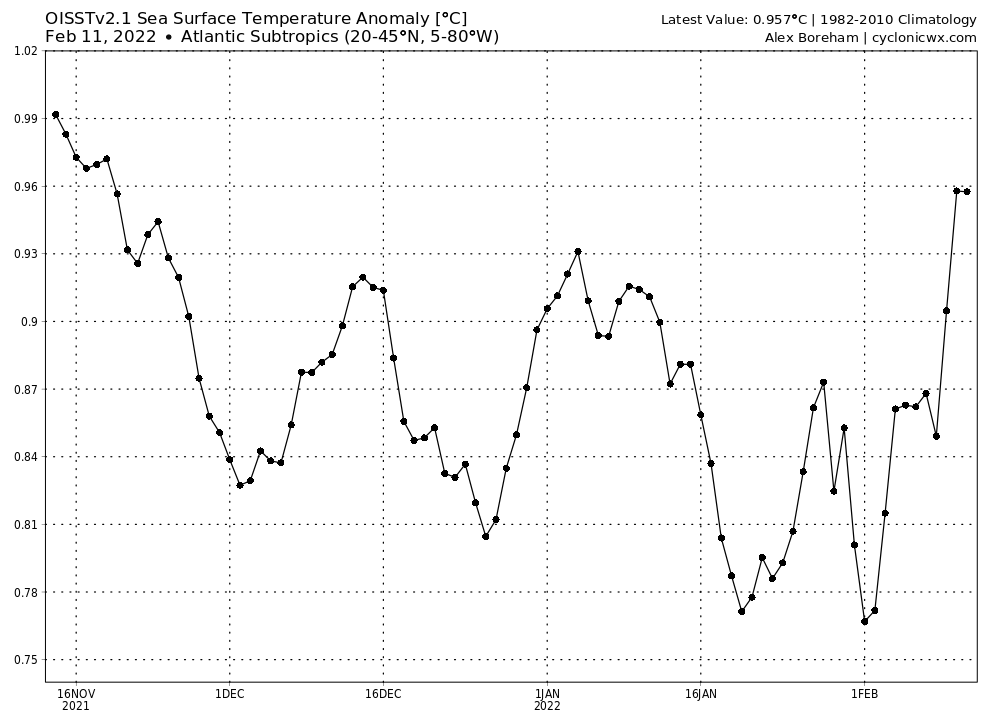
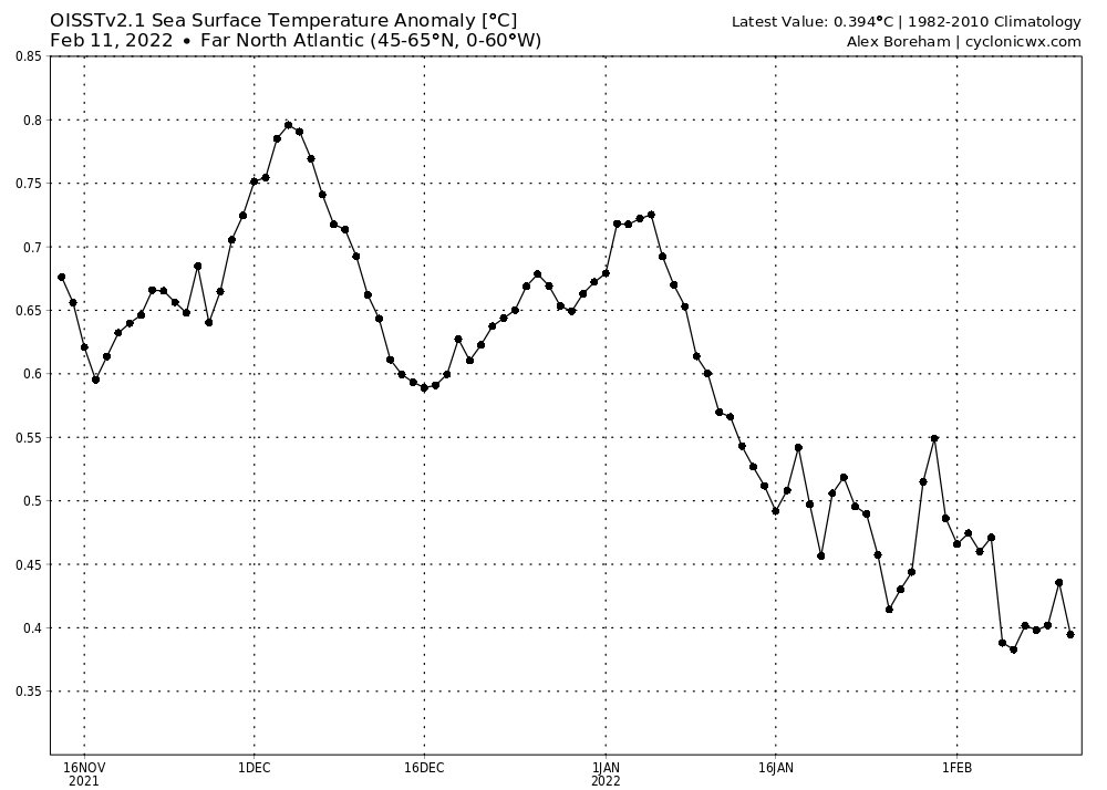
The entire story of the Atlantic pattern can be summed up with these four variables:

Image
Image
Image
Image

The Atlantic Nino will tell us if we are going to have an ITCZ suppressed to the south or not. The MDR will tell us if the tropics are ripe for development. The Subtropics and Far North Atlantic together will outline the NAO pattern; if the Subtropical SSTAs are greater than the Far North Atlantic SSTAs, the NAO would be positive because of increased subtropical ridging and there would be more landfalls; if the Subtropical SSTAs are less than the Far North Atlantic SSTAs, the NAO would be negative, leading to fewer landfalls. A positive NAO would also make MDR warming more difficult because of increased MDR trade winds.
Last edited by AlphaToOmega on Sat Feb 12, 2022 9:27 am, edited 1 time in total.
1 likes   

mixedDanilo.E
Tropical Depression
Tropical Depression
Posts: 72
Joined: Sun Nov 21, 2021 8:00 am

Re: 2022 indicators: SSTs / SAL / MSLP / shear / steering / instability / images

#94 Postby mixedDanilo.E » Fri Feb 11, 2022 11:42 pm

AlphaToOmega wrote:SSTAs right now are meaningless for this hurricane season, for we are still in the 2021-2022 winter. The best tools we have are climate models, which have their issues. The CFSv2 tends to have a bias towards -AMM (especially months before hurricane season); the ECMWF also tends to have a bias towards -AMM, but it also has a +ENSO bias. Even though we are in the dark with many details, there is something we basically know for certain: +AMO. The AMO has never been negative during ASO from 1997 to 2021, and it appears as if that trend will continue.

I agree and this is what I think matters. We still have slipped into a at least semi +AMO phase by peak season since the late 90s but imma point out that imo, I think do have the best looks for February in the AMO or deep tropics Atlantic warmth than the last few years to be fully honest. And I’ve also noticed especially as of recently the Gulf of Guinea cooling down alot which in response is causing the MDR to warm a lot. Also about the CFS weeklies is it just me or do they seem to have a strong +NAO bias. I’ve just noticed they have a strong +NAO biased for the past few winters and I don’t trust it in general. Also when it comes to the SSTAs in the models for peak season I also noticed that they kinda seem to have an error in showing the deep tropics Atlantic warmth cuz if u look at the Caribbean on the CanSIPS for ASO for instance it’s very very warm and in response the Gulf of Guinea is cool too but they seem to show a warm subtropics and an empty spot in the MDR tropics and it kinda looks like an error to me - and I’ve noticed this on all models for multiple years now - they seem to have an error in properly showing the MDR SSTAs.
0 likes   

User avatar
SFLcane
S2K Supporter
S2K Supporter
Posts: 9606
Age: 46
Joined: Sat Jun 05, 2010 1:44 pm
Location: Lake Worth Florida

Re: 2022 indicators: SSTs / SAL / MSLP / shear / steering / instability / images

#95 Postby SFLcane » Sat Feb 12, 2022 1:54 pm

AlphaToOmega wrote:The entire story of the Atlantic pattern can be summed up with these four variables:

https://i.postimg.cc/TYQnX8dn/atl3Mon.gif
https://i.postimg.cc/Qdt186Cw/ssta-graph-mdrtrop.png
https://i.postimg.cc/6pmRydG3/ssta-graph-subtropatl.png
[url]https://i.postimg.cc/D0v9b0Cw/ssta-graph-
polaratl.png[/url]


The Atlantic Nino will tell us if we are going to have an ITCZ suppressed to the south or not. The MDR will tell us if the tropics are ripe for development. The Subtropics and Far North Atlantic together will outline the NAO pattern; if the Subtropical SSTAs are greater than the Far North Atlantic SSTAs, the NAO would be positive because of increased subtropical ridging and there would be more landfalls; if the Subtropical SSTAs are less than the Far North Atlantic SSTAs, the NAO would be negative, leading to fewer landfalls. A positive NAO would also make MDR warming more difficult because of increased MDR trade winds.


Wonder what it'll look like in June?
0 likes   

mixedDanilo.E
Tropical Depression
Tropical Depression
Posts: 72
Joined: Sun Nov 21, 2021 8:00 am

Re: 2022 indicators: SSTs / SAL / MSLP / shear / steering / instability / images

#96 Postby mixedDanilo.E » Sat Feb 12, 2022 2:54 pm

SFLcane wrote:
AlphaToOmega wrote:The entire story of the Atlantic pattern can be summed up with these four variables:

https://i.postimg.cc/TYQnX8dn/atl3Mon.gif
https://i.postimg.cc/Qdt186Cw/ssta-graph-mdrtrop.png
https://i.postimg.cc/6pmRydG3/ssta-graph-subtropatl.png
[url]https://i.postimg.cc/D0v9b0Cw/ssta-graph-
polaratl.png[/url]


The Atlantic Nino will tell us if we are going to have an ITCZ suppressed to the south or not. The MDR will tell us if the tropics are ripe for development. The Subtropics and Far North Atlantic together will outline the NAO pattern; if the Subtropical SSTAs are greater than the Far North Atlantic SSTAs, the NAO would be positive because of increased subtropical ridging and there would be more landfalls; if the Subtropical SSTAs are less than the Far North Atlantic SSTAs, the NAO would be negative, leading to fewer landfalls. A positive NAO would also make MDR warming more difficult because of increased MDR trade winds.


Wonder what it'll look like in June?


we'll have to see
0 likes   

AlphaToOmega
Category 5
Category 5
Posts: 1448
Joined: Sat Jun 26, 2021 10:51 am
Location: Somewhere in Massachusetts

Re: 2022 indicators: SSTs / SAL / MSLP / shear / steering / instability / images

#97 Postby AlphaToOmega » Sat Feb 12, 2022 6:08 pm

mixedDanilo.E wrote:
SFLcane wrote:
AlphaToOmega wrote:The entire story of the Atlantic pattern can be summed up with these four variables:

https://i.postimg.cc/TYQnX8dn/atl3Mon.gif
https://i.postimg.cc/Qdt186Cw/ssta-graph-mdrtrop.png
https://i.postimg.cc/6pmRydG3/ssta-graph-subtropatl.png
[url]https://i.postimg.cc/D0v9b0Cw/ssta-graph-
polaratl.png[/url]


The Atlantic Nino will tell us if we are going to have an ITCZ suppressed to the south or not. The MDR will tell us if the tropics are ripe for development. The Subtropics and Far North Atlantic together will outline the NAO pattern; if the Subtropical SSTAs are greater than the Far North Atlantic SSTAs, the NAO would be positive because of increased subtropical ridging and there would be more landfalls; if the Subtropical SSTAs are less than the Far North Atlantic SSTAs, the NAO would be negative, leading to fewer landfalls. A positive NAO would also make MDR warming more difficult because of increased MDR trade winds.


Wonder what it'll look like in June?


we'll have to see


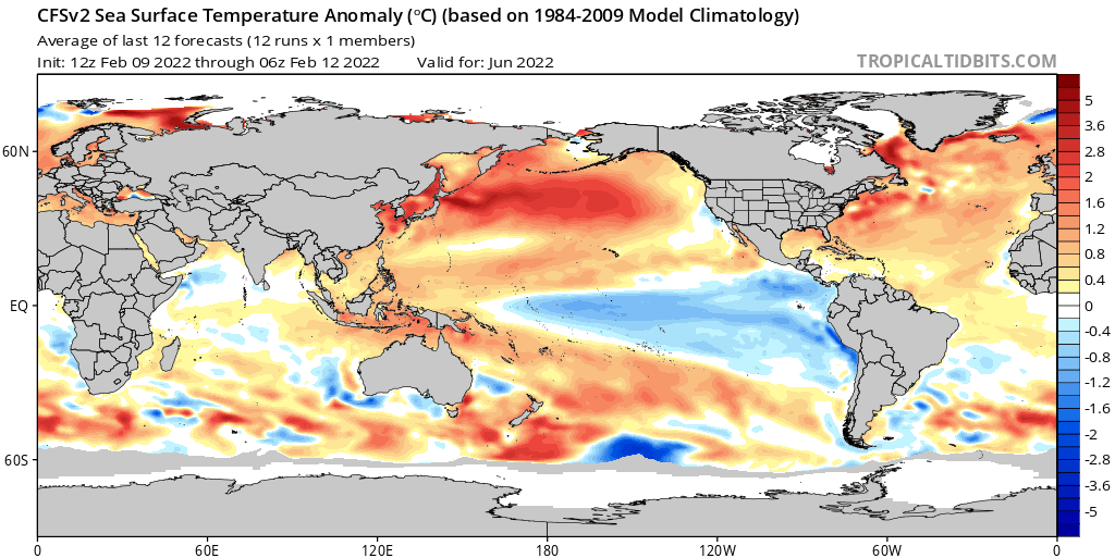
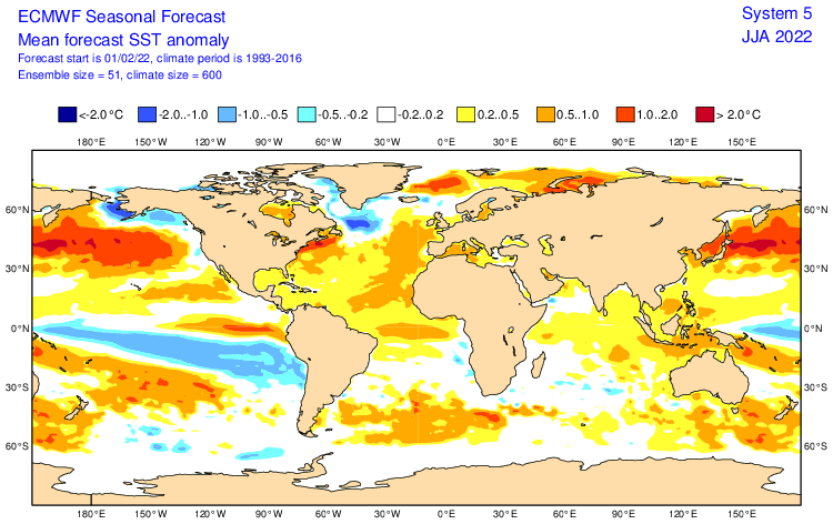
Image
Image

We do not have a strong consensus between the ECMWF and the CFSv2.
Last edited by AlphaToOmega on Sun Feb 13, 2022 5:47 am, edited 1 time in total.
1 likes   

mixedDanilo.E
Tropical Depression
Tropical Depression
Posts: 72
Joined: Sun Nov 21, 2021 8:00 am

Re: 2022 indicators: SSTs / SAL / MSLP / shear / steering / instability / images

#98 Postby mixedDanilo.E » Sat Feb 12, 2022 8:01 pm

AlphaToOmega wrote:
mixedDanilo.E wrote:
SFLcane wrote:
Wonder what it'll look like in June?


we'll have to see


https://i.postimg.cc/Pq0R9DRc/cfs-mon-01-ssta-global-4.png
https://i.postimg.cc/Xq1F1f2B/ps2png-worker-commands-5cc9d5d68-b4z4c-6fe5cac1a363ec1525f54343b6cc9fd8-2h-C4-EX.png

It seems we have somewhat of a consensus between the ECMWF and the CFSv2 for June; both show a +AMM, a neutral Atlantic Nino, an above-average MDR, a -ENSO, a -PDO, and a -IOD. They also both show a +AMO, but that was almost guaranteed since the AMO has always been positive since February 2019. The difference comes down to the NAO; the ECMWF shows a +NAO; the CFSv2 shows a neutral NAO.


https://www.tropicaltidbits.com/analysi ... obal_5.png

CanSIPS for reference too
0 likes   

AlphaToOmega
Category 5
Category 5
Posts: 1448
Joined: Sat Jun 26, 2021 10:51 am
Location: Somewhere in Massachusetts

Re: 2022 indicators: SSTs / SAL / MSLP / shear / steering / instability / images

#99 Postby AlphaToOmega » Sun Feb 13, 2022 8:56 am

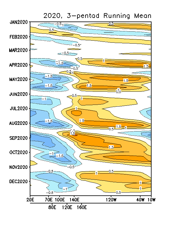
We are also going to have to look at MJO strength this season. Will this season be like 2020 (one with consistent -VP over the Eastern Hemisphere and +VP over the Western Hemisphere), or will it be like 2021 (one where the MJO remains prominent into hurricane season)? It is too early to tell.

Image
Image

If the MJO progression is like 2020, we would likely have consistent activity that more or less follows a bell curve peaking in September. If the MJO progression is like 2021, we would likely have intense bursts of activity followed by lulls. If the SSTA pattern is perfect for tropical cyclogenesis like in 2020 (which we still do not know yet), a 2020-esque progression would allow the season to reach its full potential, and a 2021-esque progression would limit the season's activity.
3 likes   

mixedDanilo.E
Tropical Depression
Tropical Depression
Posts: 72
Joined: Sun Nov 21, 2021 8:00 am

Re: 2022 indicators: SSTs / SAL / MSLP / shear / steering / instability / images

#100 Postby mixedDanilo.E » Sun Feb 13, 2022 9:50 am

AlphaToOmega wrote:We are also going to have to look at MJO strength this season. Will this season be like 2020 (one with consistent -VP over the Eastern Hemisphere and +VP over the Western Hemisphere), or will it be like 2021 (one where the MJO remains prominent into hurricane season)? It is too early to tell.

https://i.postimg.cc/44zVDXRL/tm-long-order-2020.gif
https://i.postimg.cc/8PNMDx11/tm-long-order-2021.gif

If the MJO progression is like 2020, we would likely have consistent activity that more or less follows a bell curve peaking in September. If the MJO progression is like 2021, we would likely have intense bursts of activity followed by lulls. If the SSTA pattern is perfect for tropical cyclogenesis like in 2020 (which we still do not know yet), a 2020-esque progression would allow the season to reach its full potential, and a 2021-esque progression would limit the season's activity.


We'll have to see but I think that also the Atlantic SSTA pattern will affect how the MJO plays out:
0 likes   


Return to “Talkin' Tropics”

Who is online

Users browsing this forum: CycloneNC, Google Adsense [Bot], KirbyDude25, NotSparta and 189 guests