https://twitter.com/AndyHazelton/status/1544330133196111873
2022 Indicators (SSTs/SAL/MSLP/Shear/Steering/Instability) and >Day 16 Models
Moderator: S2k Moderators
Forum rules

The posts in this forum are NOT official forecasts and should not be used as such. They are just the opinion of the poster and may or may not be backed by sound meteorological data. They are NOT endorsed by any professional institution or STORM2K. For official information, please refer to products from the National Hurricane Center and National Weather Service.
-
skyline385

- Category 5

- Posts: 2444
- Age: 33
- Joined: Wed Aug 26, 2020 11:15 pm
- Location: Palm Beach County FL
-
skyline385
- Category 5
- Posts: 2444
- Age: 33
- Joined: Wed Aug 26, 2020 11:15 pm
- Location: Palm Beach County FL
2022 Indicators (SSTs/SAL/MSLP/Shear/Steering/Instability) and >Day 16 Models
Keeping in mind that the EURO SEAS5 was adjusted last year to account for it underperforming and that we have some MDR cooling going in the next week along with a supposedly suppressed July, i agree with them.
https://twitter.com/andyhazelton/status/1544298965142835202
https://twitter.com/cyclonicwx/status/1544299389132460033
https://twitter.com/andyhazelton/status/1544298965142835202
https://twitter.com/cyclonicwx/status/1544299389132460033
Last edited by skyline385 on Tue Jul 05, 2022 9:57 am, edited 1 time in total.
0 likes
-
toad strangler

- S2K Supporter

- Posts: 4162
- Joined: Sun Jul 28, 2013 3:09 pm
- Location: Earth
- Contact:
Re: 2022 Indicators (SSTs/SAL/MSLP/Shear/Steering/Instability) and >Day 16 Models
skyline385 wrote:cheezyWXguy wrote:Category5Kaiju wrote:
I'm personally not surprised by this. However, it's still predicting a season with 140% the norm in terms of ACE, which is roughly 185-190 ACE. That's still a formidable season if it pans out imho
Yeah that’s still easily hyperactive, and above 2020 by ACE
Yes but it’s no longer predicting its highest season forecast ever which lots of folks were taking at face value before so that’s important imo. ACE of 160-180 is what a lot of experts have been saying and falls in line with the predictions.
Why would anyone take a long range forecast at face value? Anyone who has at least a modest understanding of the output. That doesn't make much sense in my coconut. These products are great talking points, and tools to hedge on a forecast one way or the other somewhat but FACE VALUE?
4 likes
-
SFLcane

- S2K Supporter
- Posts: 9609
- Age: 46
- Joined: Sat Jun 05, 2010 1:44 pm
- Location: Lake Worth Florida
Re: 2022 Indicators (SSTs/SAL/MSLP/Shear/Steering/Instability) and >Day 16 Models
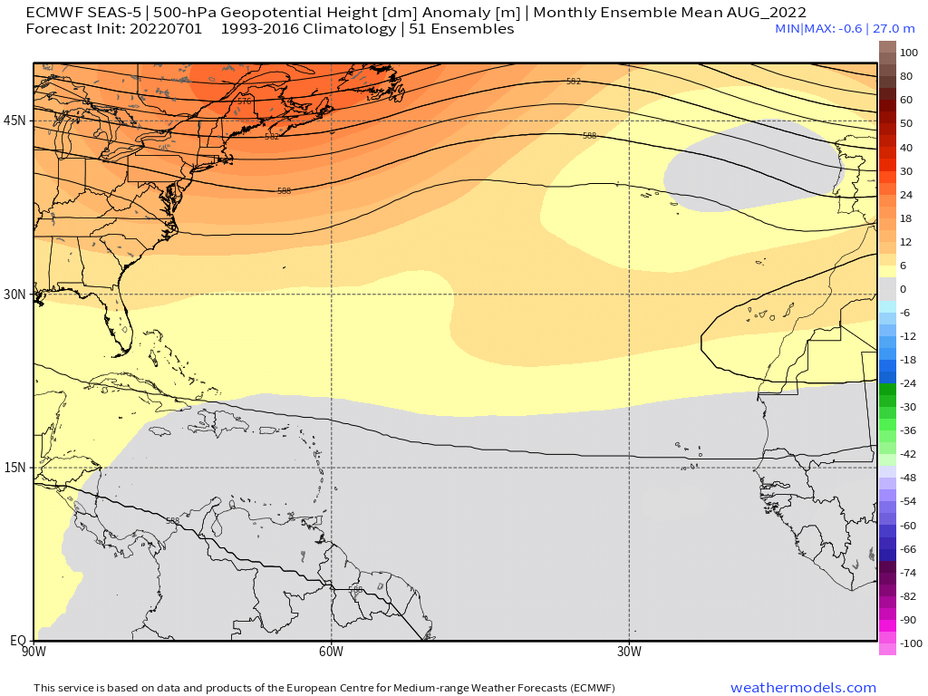
What happenend to the trof? Dangerous look! 
4 likes
-
cycloneye

- Admin

- Posts: 139132
- Age: 67
- Joined: Thu Oct 10, 2002 10:54 am
- Location: San Juan, Puerto Rico
Re: 2022 Indicators (SSTs/SAL/MSLP/Shear/Steering/Instability) and >Day 16 Models
What matters to me and our friends in the Caribbean islands is if a storm or hurricane will move thru. It only takes one to do all the harm to an island so I dont care about the numbers.
12 likes
Visit the Caribbean-Central America Weather Thread where you can find at first post web cams,radars
and observations from Caribbean basin members Click Here
and observations from Caribbean basin members Click Here
-
SFLcane
- S2K Supporter
- Posts: 9609
- Age: 46
- Joined: Sat Jun 05, 2010 1:44 pm
- Location: Lake Worth Florida
Re: 2022 Indicators (SSTs/SAL/MSLP/Shear/Steering/Instability) and >Day 16 Models
cycloneye wrote:What matters to me and our friends in the Caribbean islands is if a storm or hurricane will move thru. It only takes one to do all the harm to an island so I dont care about the numbers.
This!
Certainly that ridge projection from the ECMWF would certainly put the islands at high risk surely.
0 likes
-
skyline385
- Category 5
- Posts: 2444
- Age: 33
- Joined: Wed Aug 26, 2020 11:15 pm
- Location: Palm Beach County FL
Re: 2022 Indicators (SSTs/SAL/MSLP/Shear/Steering/Instability) and >Day 16 Models
cycloneye wrote:What matters to me and our friends in the Caribbean islands is if a storm or hurricane will move thru. It only takes one to do all the harm to an island so I dont care about the numbers.
Agree 100% on that, no matter where you live it just takes one storm to destroy your livelihood.
0 likes
Re: 2022 Indicators (SSTs/SAL/MSLP/Shear/Steering/Instability) and >Day 16 Models
skyline385 wrote:cycloneye wrote:What matters to me and our friends in the Caribbean islands is if a storm or hurricane will move thru. It only takes one to do all the harm to an island so I dont care about the numbers.
Agree 100% on that, no matter where you live it just takes one storm to destroy your livelihood.
So true, when we choose to live in areas that are at risk of impacts from a Cyclone, we assume the risks that go along with these weather events. That is why I personally feel it is vital to remain informed, alert, and ready to act accordingly, whenever there is a threat to our well-being, our homes and livelihoods. That's why S2K is my one stop shopping for valuable information.
4 likes
-
Category5Kaiju

- Category 5
- Posts: 3360
- Age: 22
- Joined: Thu Dec 24, 2020 12:45 pm
- Location: Seattle
Re: 2022 Indicators (SSTs/SAL/MSLP/Shear/Steering/Instability) and >Day 16 Models
2019, 1992, and 1983 are perfect examples of why I personally think sometimes, the quality of individual storms and their impacts can be more important and historically significant than looking at the season as a whole and whether it’s hyperactive, above average, below average, or what not.
Hypothetically speaking, if this season were to end with Danielle but have Danielle slam into Miami as a 190 mph Cat 5 storm, then I’m pretty sure 2022’s legacy and its significantly below average ACE activity status would become irrelevant compared to the damages it did with just one single storm.
Hypothetically speaking, if this season were to end with Danielle but have Danielle slam into Miami as a 190 mph Cat 5 storm, then I’m pretty sure 2022’s legacy and its significantly below average ACE activity status would become irrelevant compared to the damages it did with just one single storm.
9 likes
Unless explicitly stated, all information covered in my posts is based on my opinions and observations. Please refer to a professional meteorologist or an accredited weather research agency otherwise, especially if serious decisions must be made in the event of a potentially life-threatening tropical storm or hurricane.


Re: 2022 Indicators (SSTs/SAL/MSLP/Shear/Steering/Instability) and >Day 16 Models
SFLcane wrote:skyline385 wrote:https://twitter.com/andyhazelton/status/1544299397294526466
Season is over.
Yep, season canceled
This is honestly my least favorite time of year for tracking the tropics because no matter how you spin it there is cause for some season cancel speculation. Trades look to remain strong over the Atlantic for the time being but I honestly doubt they will stay that way for long. MDR is always warm enough to support development come peak so as long as the subtropics remain cooler than normal too it’s a favorable look in my opinion.
9 likes
Re: 2022 Indicators (SSTs/SAL/MSLP/Shear/Steering/Instability) and >Day 16 Models
Category5Kaiju wrote:2019, 1992, and 1983 are perfect examples of why I personally think sometimes, the quality of individual storms and their impacts can be more important and historically significant than looking at the season as a whole and whether it’s hyperactive, above average, below average, or what not.
Hypothetically speaking, if this season were to end with Danielle but have Danielle slam into Miami as a 190 mph Cat 5 storm, then I’m pretty sure 2022’s legacy and its significantly below average ACE activity status would become irrelevant compared to the damages it did with just one single storm.
It would seem that can be said as well in the WPAC? Please correct me if I am mistaken, last year's Typhoon season was quiet in comparison to other seasons in that region. Can you make a comparison with the current activity, versus other seasons?, with possibly some examples?
Last edited by underthwx on Tue Jul 05, 2022 12:15 pm, edited 1 time in total.
0 likes
-
skyline385
- Category 5
- Posts: 2444
- Age: 33
- Joined: Wed Aug 26, 2020 11:15 pm
- Location: Palm Beach County FL
2022 Indicators (SSTs/SAL/MSLP/Shear/Steering/Instability) and >Day 16 Models
WiscoWx02 wrote:SFLcane wrote:skyline385 wrote:https://twitter.com/andyhazelton/status/1544299397294526466
Season is over.
Yep, season canceled
This is honestly my least favorite time of year for tracking the tropics because no matter how you spin it there is cause for some season cancel speculation. Trades look to remain strong over the Atlantic for the time being but I honestly doubt they will stay that way for long. MDR is always warm enough to support development come peak so as long as the subtropics remain cooler than normal too it’s a favorable look in my opinion.
Part of the problem is folks jumping to extremes. Andy is simply saying in the original tweet that the current conditions do not look similar to extremely high end seasons, no one should be looking at that tweet and instantly jumping to season cancelled from it. I am not trying to be rude here so apologies if i come off like that (English isn’t my first language), the season canceled memes annoy me as much as anyone else.
3 likes
Re: 2022 Indicators (SSTs/SAL/MSLP/Shear/Steering/Instability) and >Day 16 Models
skyline385 wrote:WiscoWx02 wrote:SFLcane wrote:
Season is over.
Yep, season canceled
This is honestly my least favorite time of year for tracking the tropics because no matter how you spin it there is cause for some season cancel speculation. Trades look to remain strong over the Atlantic for the time being but I honestly doubt they will stay that way for long. MDR is always warm enough to support development come peak so as long as the subtropics remain cooler than normal too it’s a favorable look in my opinion.
Part of the problem is folks jumping to extremes. Andy is simply saying in the original tweet that the current conditions do not look similar to extremely high end seasons, no one should be looking at that tweet and instantly jumping to season cancelled from it. I am not trying to be rude here so apologies if i come off like that (English isn’t my first language), the season canceled memes annoy me as much as anyone else.
And I doubt anyone is, just joking around
1 likes
-
toad strangler
- S2K Supporter
- Posts: 4162
- Joined: Sun Jul 28, 2013 3:09 pm
- Location: Earth
- Contact:
Re: 2022 Indicators (SSTs/SAL/MSLP/Shear/Steering/Instability) and >Day 16 Models
WiscoWx02 wrote: My recommendation heading into the season cancel peak season is just not to expect any extreme on one end or the other and you won’t fall for it as easily like I used to. Overall activity isn’t even what matters, it’s the WHERE.
Yup, just got off the phone with 1992 and there was some pretty good agreement with this point.
Can you imagine the "A" storm not popping until late August 'round these parts now? haha
That said, Seeing Bonnie come from such a vigorous AEW (not genesis in the MDR) in JUNE leads me to believe there are low chances of the season under performing.
Last edited by toad strangler on Tue Jul 05, 2022 12:50 pm, edited 1 time in total.
0 likes

Re: 2022 Indicators (SSTs/SAL/MSLP/Shear/Steering/Instability) and >Day 16 Models
Oh great, that Euro forecast is now showing enhanced TC activity in the Gulf. Like we haven’t gotten enough of that over the last two years. I’m half expecting another female name high-end Cat 4 in the Gulf at the end of August this year.
0 likes
Irene '11 Sandy '12 Hermine '16 5/15/2018 Derecho Fay '20 Isaias '20 Elsa '21 Henri '21 Ida '21
I am only a meteorology enthusiast who knows a decent amount about tropical cyclones. Look to the professional mets, the NHC, or your local weather office for the best information.
I am only a meteorology enthusiast who knows a decent amount about tropical cyclones. Look to the professional mets, the NHC, or your local weather office for the best information.
Re: 2022 Indicators (SSTs/SAL/MSLP/Shear/Steering/Instability) and >Day 16 Models
aspen wrote:Oh great, that Euro forecast is now showing enhanced TC activity in the Gulf. Like we haven’t gotten enough of that over the last two years. I’m half expecting another female name high-end Cat 4 in the Gulf at the end of August this year.
Can you provide an example of this Euro forecast? I am not that familiar with the reliability of the Euro forecast, (or how to look at it myself)
0 likes
-
captainbarbossa19

- Category 5
- Posts: 1039
- Joined: Wed Aug 21, 2019 11:09 pm
- Location: Starkville, MS
Re: 2022 Indicators (SSTs/SAL/MSLP/Shear/Steering/Instability) and >Day 16 Models
I have been posting this every year in the indicators thread, so I will post it again to remind people of what we go through here. Haha!
Captain Barbossa's Tropical Cyclone Timeline:
1. June 1st: Everyone is excited about the upcoming season. Many are anticipating upcoming action later in the month, but most know that the real action will most likely start in August.
2. July 1st: One or two TCs manage to form in June. Many complain about how weak and disorganized the cyclones are.
3. July 15th: Lots of SAL is present in the Atlantic basin. However, most people are not surprised by this, as they were expecting it.
4. August 1st: Atlantic is still slow. Dry, stable air is present in the tropics. However, models are beginning to suggest things will be changing within a few weeks.
5. August 15th: Models show nothing in the near-future. Many are becoming skeptical about the season amounting to anything significant.
6. August 23rd: There are multiple invests in the Atlantic and conditions are rapidly beginning to change. The models begin to show cyclogenesis. Many quickly change their minds about a quieter season.
7. August 24th: Some experts continue to doubt signs of the Atlantic awakening. These experts issue outlooks that support original ideas of a quieter season.
8. August 31st: There is now at least one active TC. There is a potential that at least one TC could become a hurricane. Many people appear shocked by the increased activity.
9. September 30th: Several TCs have already formed and dissipated. A few who suggested that the season would be quiet now state that they always knew the Atlantic would spring to life.
10. November 30th: The last storm probably has dissipated by this point. Many look back at the season and state that they are surprised with the outcome.
9 likes
Who is online
Users browsing this forum: No registered users and 184 guests