[quote="cycloneye"]Interesting discussions on twitter world that ends with the bell.
https://twitter.com/dmorris9661/status/1557461327651786755
https://twitter.com/dmorris9661/status/1557462262323073030
https://twitter.com/AndyHazelton/status/1557464228495253504
https://twitter.com/DylanFedericoWX/status/1557467022212186112
Danny Morris……. “ The pattern over the ATL has been responsible for its shutdown for most of the year.”
It’s statements like these that have me increasingly narrowing my social media focus. This statement is just full of fail talking about a basin that has been shutdown a climatology period that it is NORMAL to be very slow. Ughhh
2022 Indicators (SSTs/SAL/MSLP/Shear/Steering/Instability) and >Day 16 Models
Moderator: S2k Moderators
Forum rules

The posts in this forum are NOT official forecasts and should not be used as such. They are just the opinion of the poster and may or may not be backed by sound meteorological data. They are NOT endorsed by any professional institution or STORM2K. For official information, please refer to products from the National Hurricane Center and National Weather Service.
-
toad strangler

- S2K Supporter

- Posts: 4162
- Joined: Sun Jul 28, 2013 3:09 pm
- Location: Earth
- Contact:
-
weeniepatrol

- Category 3

- Posts: 857
- Joined: Sat Aug 22, 2020 5:30 pm
- Location: WA State
Re: 2022 Indicators (SSTs/SAL/MSLP/Shear/Steering/Instability) and >Day 16 Models
toad strangler wrote:cycloneye wrote:Interesting discussions on twitter world that ends with the bell.
https://twitter.com/dmorris9661/status/1557461327651786755
https://twitter.com/dmorris9661/status/1557462262323073030
https://twitter.com/AndyHazelton/status/1557464228495253504
https://twitter.com/DylanFedericoWX/status/1557467022212186112
Danny Morris……. “ The pattern over the ATL has been responsible for its shutdown for most of the year.”
It’s statements like these that have me increasingly narrowing my social media focus. This statement is just full of fail talking about a basin that has been shutdown a climatology period that it is NORMAL to be very slow. Ughhh
Yeah, this is the intraseasonal nadir.
3 likes

Re: 2022 Indicators (SSTs/SAL/MSLP/Shear/Steering/Instability) and >Day 16 Models
With 97L fading, that’s two model-hyped MDR storms that never verified. Maybe third time’s the charm and we’ll get one next week?
We’re running behind every season of the post-2015 active phase so far. Even 2018 and 2019 had at least one hurricane by now, although 2018 had a nearly dead August until Florence formed at the very end.
We’re running behind every season of the post-2015 active phase so far. Even 2018 and 2019 had at least one hurricane by now, although 2018 had a nearly dead August until Florence formed at the very end.
5 likes
Irene '11 Sandy '12 Hermine '16 5/15/2018 Derecho Fay '20 Isaias '20 Elsa '21 Henri '21 Ida '21
I am only a meteorology enthusiast who knows a decent amount about tropical cyclones. Look to the professional mets, the NHC, or your local weather office for the best information.
I am only a meteorology enthusiast who knows a decent amount about tropical cyclones. Look to the professional mets, the NHC, or your local weather office for the best information.

Re: 2022 Indicators (SSTs/SAL/MSLP/Shear/Steering/Instability) and >Day 16 Models

Given we had only one storm after September last year, the CFS is showing significant sinking air over the tropical Atlantic and Africa during September, and the tropical waves continue to come off too far north to escape the cooler waters/dust, I think we should at least start asking if there's something larger going on that we're not seeing.
4 likes
The above post is not official and should not be used as such. It is the opinion of the poster and may or may not be backed by sound meteorological data. It is not endorsed by any professional institution or storm2k.org. For official information, please refer to the NHC and NWS products.
-
InfernoFlameCat

- Category 5

- Posts: 1966
- Age: 21
- Joined: Mon Dec 14, 2020 10:52 am
- Location: Buford, GA
Re: 2022 Indicators (SSTs/SAL/MSLP/Shear/Steering/Instability) and >Day 16 Models
If someone references the CFS again, imma bang my head on something. CFS is unreliable.
4 likes
I am by no means a professional. DO NOT look at my forecasts for official information or make decisions based on what I post.
Goal: to become a registered expert over tropical and subtropical cyclones.
Goal: to become a registered expert over tropical and subtropical cyclones.
Re: 2022 Indicators (SSTs/SAL/MSLP/Shear/Steering/Instability) and >Day 16 Models
InfernoFlameCat wrote:If someone references the CFS again, imma bang my head on something. CFS is unreliable.
It's been quite reliable as a climate model. What's going on with the Atlantic is not the normal pre-bell quiet, something is definitely off and there's no need to freak out when somebody points it out, as it adds literally nothing to the discussion.
8 likes
The above post is not official and should not be used as such. It is the opinion of the poster and may or may not be backed by sound meteorological data. It is not endorsed by any professional institution or storm2k.org. For official information, please refer to the NHC and NWS products.

Re: 2022 Indicators (SSTs/SAL/MSLP/Shear/Steering/Instability) and >Day 16 Models
Hammy wrote:https://i.imgur.com/iS6QPF5.png
Given we had only one storm after September last year, the CFS is showing significant sinking air over the tropical Atlantic and Africa during September, and the tropical waves continue to come off too far north to escape the cooler waters/dust, I think we should at least start asking if there's something larger going on that we're not seeing.
Check out the picture in this article.
https://www.earthdata.nasa.gov/learn/sensing-our-planet/saharan-dust-versus-atlantic-hurricanes
Debby was the first Cape Verde storm and came August 21 that year.
2 likes
Re: 2022 Indicators (SSTs/SAL/MSLP/Shear/Steering/Instability) and >Day 16 Models
Nimbus wrote:Hammy wrote:https://i.imgur.com/iS6QPF5.png
Given we had only one storm after September last year, the CFS is showing significant sinking air over the tropical Atlantic and Africa during September, and the tropical waves continue to come off too far north to escape the cooler waters/dust, I think we should at least start asking if there's something larger going on that we're not seeing.
Check out the picture in this article.
https://en.wikipedia.org/wiki/2006_Atla ... hurricanes
Debby was the first Cape Verde storm and came August 21 that year.
Most of the first seasons I tracked back in the late 1990s had similarly late starts. But we're seeing things out of the ordinary with the modeling--the usually overzealous GFS is showing nothing the entire way out, ten days from the bell point, and the ensembles are showing little to no activity.
It seems like the waves are coming off so far north that they're actually contributing to the amount of dust, and as a result you're not getting any stronger waves to the south of it.
1 likes
The above post is not official and should not be used as such. It is the opinion of the poster and may or may not be backed by sound meteorological data. It is not endorsed by any professional institution or storm2k.org. For official information, please refer to the NHC and NWS products.

Re: 2022 Indicators (SSTs/SAL/MSLP/Shear/Steering/Instability) and >Day 16 Models
Hammy wrote:https://i.imgur.com/iS6QPF5.png
Given we had only one storm after September last year, the CFS is showing significant sinking air over the tropical Atlantic and Africa during September, and the tropical waves continue to come off too far north to escape the cooler waters/dust, I think we should at least start asking if there's something larger going on that we're not seeing.
The two bolded parts here contradict each other. One reason why the Atlantic had little activity in Oct-Nov 2021 was that the ITCZ was too far south (and sent waves to EPAC that developed into Pamela, Rick etc), not too far north.
Even if the 2022 season underperforms, it probably won't be for the same reasons as late 2021.
3 likes
Re: 2022 Indicators (SSTs/SAL/MSLP/Shear/Steering/Instability) and >Day 16 Models
Teban54 wrote:Hammy wrote:https://i.imgur.com/iS6QPF5.png
Given we had only one storm after September last year, the CFS is showing significant sinking air over the tropical Atlantic and Africa during September, and the tropical waves continue to come off too far north to escape the cooler waters/dust, I think we should at least start asking if there's something larger going on that we're not seeing.
The two bolded parts here contradict each other. One reason why the Atlantic had little activity in Oct-Nov 2021 was that the ITCZ was too far south (and sent waves to EPAC that developed into Pamela, Rick etc), not too far north.
Even if the 2022 season underperforms, it probably won't be for the same reasons as late 2021.
The eastern basin was still producing strong waves into early November so the ITCZ over the Atlantic was still displaced to the north. It almost seems like they're coming off too far north, getting shoved too far south to develop in the Caribbean.
I do wonder if the heat wave in Europe is contributing--or at least the synoptic setup--as the jet stream is displaced farther north, so the southern portion of that high (the ITCZ) has gone north with it.
0 likes
The above post is not official and should not be used as such. It is the opinion of the poster and may or may not be backed by sound meteorological data. It is not endorsed by any professional institution or storm2k.org. For official information, please refer to the NHC and NWS products.
-
cycloneye

- Admin

- Posts: 139028
- Age: 67
- Joined: Thu Oct 10, 2002 10:54 am
- Location: San Juan, Puerto Rico
Re: 2022 Indicators (SSTs/SAL/MSLP/Shear/Steering/Instability) and >Day 16 Models
Hammy wrote:Teban54 wrote:Hammy wrote:https://i.imgur.com/iS6QPF5.png
Given we had only one storm after September last year, the CFS is showing significant sinking air over the tropical Atlantic and Africa during September, and the tropical waves continue to come off too far north to escape the cooler waters/dust, I think we should at least start asking if there's something larger going on that we're not seeing.
The two bolded parts here contradict each other. One reason why the Atlantic had little activity in Oct-Nov 2021 was that the ITCZ was too far south (and sent waves to EPAC that developed into Pamela, Rick etc), not too far north.
Even if the 2022 season underperforms, it probably won't be for the same reasons as late 2021.
The eastern basin was still producing strong waves into early November so the ITCZ over the Atlantic was still displaced to the north. It almost seems like they're coming off too far north, getting shoved too far south to develop in the Caribbean.
I do wonder if the heat wave in Europe is contributing--or at least the synoptic setup--as the jet stream is displaced farther north, so the southern portion of that high (the ITCZ) has gone north with it.
I had mentioned about that heat wave thing way back in this thread. We have so many things to look at that is so confusing in a third La Niña year.
1 likes
Visit the Caribbean-Central America Weather Thread where you can find at first post web cams,radars
and observations from Caribbean basin members Click Here
and observations from Caribbean basin members Click Here


Re: 2022 Indicators (SSTs/SAL/MSLP/Shear/Steering/Instability) and >Day 16 Models
captainbarbossa19 wrote:WiscoWx02 wrote:MHC Tracking wrote:Model output in the long-range concerning dry air and shear is just as unreliable as it is concerning long-range TC signals...not sure why you're taking it as gospel
Watch him be right though
Yeah bad idea to look at models and say they will be 100% current. Models tend to “nowcast” more than anything this time of year and assume the dry air and wavebreaking will continue on overdrive simply because it is now. I remember this happening in almost every single year if not EVERY single year. Trust me, once we get to August 20th, things should start to stir. I think we need that timeline of the hurricane season to be reposted just as a reminder of where we are at
Are you referring to this timeline?captainbarbossa19 wrote:4. August 1st: Atlantic is still slow. Dry, stable air is present in the tropics. However, models are beginning to suggest things will be changing within a few weeks.
5. August 15th: Models show nothing in the near-future. Many are becoming skeptical about the season amounting to anything significant.
Yep!!!!
3 likes
Re: 2022 Indicators (SSTs/SAL/MSLP/Shear/Steering/Instability) and >Day 16 Models
Hammy wrote:https://i.imgur.com/iS6QPF5.png
Given we had only one storm after September last year, the CFS is showing significant sinking air over the tropical Atlantic and Africa during September, and the tropical waves continue to come off too far north to escape the cooler waters/dust, I think we should at least start asking if there's something larger going on that we're not seeing.
I’ve been asking that ever since the abrupt shutdown in activity after Sam. It feels like the same struggles of ON 2021 — waves ending up too low (Bonnie, every GFS WCar storm in late 2021) while the EPac is abnormally active for such a strong La Niña. Maybe we’re just too used to the hyperactive early 2020 and 2021 seasons, but even comparing 2022 to other seasons that took a while to get going like 2004, 2010, 2018, and 2019, we’re still behind because all four had at least one hurricane by now. Plus, most favorable indicators are not verifying or yielding much activity. I highly doubt we get the Caribbean Cruisers many people anticipated early on.
4 likes
Irene '11 Sandy '12 Hermine '16 5/15/2018 Derecho Fay '20 Isaias '20 Elsa '21 Henri '21 Ida '21
I am only a meteorology enthusiast who knows a decent amount about tropical cyclones. Look to the professional mets, the NHC, or your local weather office for the best information.
I am only a meteorology enthusiast who knows a decent amount about tropical cyclones. Look to the professional mets, the NHC, or your local weather office for the best information.
-
cycloneye
- Admin
- Posts: 139028
- Age: 67
- Joined: Thu Oct 10, 2002 10:54 am
- Location: San Juan, Puerto Rico
Re: 2022 Indicators (SSTs/SAL/MSLP/Shear/Steering/Instability) and >Day 16 Models
3 likes
Visit the Caribbean-Central America Weather Thread where you can find at first post web cams,radars
and observations from Caribbean basin members Click Here
and observations from Caribbean basin members Click Here
-
weeniepatrol
- Category 3
- Posts: 857
- Joined: Sat Aug 22, 2020 5:30 pm
- Location: WA State
Re: 2022 Indicators (SSTs/SAL/MSLP/Shear/Steering/Instability) and >Day 16 Models
2013! Wavebreaking! Cool Canary Current!
https://twitter.com/philklotzbach/status/1557507259831160832
https://twitter.com/philklotzbach/status/1557507259831160832
0 likes
Re: 2022 Indicators (SSTs/SAL/MSLP/Shear/Steering/Instability) and >Day 16 Models
aspen wrote:Hammy wrote:https://i.imgur.com/iS6QPF5.png
Given we had only one storm after September last year, the CFS is showing significant sinking air over the tropical Atlantic and Africa during September, and the tropical waves continue to come off too far north to escape the cooler waters/dust, I think we should at least start asking if there's something larger going on that we're not seeing.
I’ve been asking that ever since the abrupt shutdown in activity after Sam. It feels like the same struggles of ON 2021 — waves ending up too low (Bonnie, every GFS WCar storm in late 2021) while the EPac is abnormally active for such a strong La Niña. Maybe we’re just too used to the hyperactive early 2020 and 2021 seasons, but even comparing 2022 to other seasons that took a while to get going like 2004, 2010, 2018, and 2019, we’re still behind because all four had at least one hurricane by now. Plus, most favorable indicators are not verifying or yielding much activity. I highly doubt we get the Caribbean Cruisers many people anticipated early on.
I remember thinking at the end of last year that quick shut down was a sign of something bigger because there should have been several cyclones in October. The entire northern hemisphere has been mostly devoid of tropical cyclones ever since or tropical cyclones that actually reached their full potential (minus a typhoon or two) and Darby. The entire northern hemisphere seems off yes. That doesn’t mean it still can’t be a busy Atlantic hurricane season by any means but these issues go back to last October I agree 100%.
1 likes
-
weeniepatrol
- Category 3
- Posts: 857
- Joined: Sat Aug 22, 2020 5:30 pm
- Location: WA State
Re: 2022 Indicators (SSTs/SAL/MSLP/Shear/Steering/Instability) and >Day 16 Models
https://twitter.com/philklotzbach/status/1557508180380225536
2009 was a Strong El Nino with an ONI peak of +1.6.
Lid is coming off soon, folks.
2009 was a Strong El Nino with an ONI peak of +1.6.
Lid is coming off soon, folks.
3 likes
-
tolakram
- Admin
- Posts: 19165
- Age: 60
- Joined: Sun Aug 27, 2006 8:23 pm
- Location: Florence, KY (name is Mark)
Re: 2022 Indicators (SSTs/SAL/MSLP/Shear/Steering/Instability) and >Day 16 Models
aspen wrote:Hammy wrote:https://i.imgur.com/iS6QPF5.png
Given we had only one storm after September last year, the CFS is showing significant sinking air over the tropical Atlantic and Africa during September, and the tropical waves continue to come off too far north to escape the cooler waters/dust, I think we should at least start asking if there's something larger going on that we're not seeing.
I’ve been asking that ever since the abrupt shutdown in activity after Sam. It feels like the same struggles of ON 2021 — waves ending up too low (Bonnie, every GFS WCar storm in late 2021) while the EPac is abnormally active for such a strong La Niña. Maybe we’re just too used to the hyperactive early 2020 and 2021 seasons, but even comparing 2022 to other seasons that took a while to get going like 2004, 2010, 2018, and 2019, we’re still behind because all four had at least one hurricane by now. Plus, most favorable indicators are not verifying or yielding much activity. I highly doubt we get the Caribbean Cruisers many people anticipated early on.
I'm doing what I did the last time we had a full on season cancel fest. Making sure I quote the posts.
It's August 10th and nothing significant has changed.
7 likes
M a r k
- - - - -
Join us in chat: Storm2K Chatroom Invite. Android and IOS apps also available.
The posts in this forum are NOT official forecasts and should not be used as such. Posts are NOT endorsed by any professional institution or STORM2K.org. For official information and forecasts, please refer to NHC and NWS products.
-
SFLcane

- S2K Supporter
- Posts: 9606
- Age: 46
- Joined: Sat Jun 05, 2010 1:44 pm
- Location: Lake Worth Florida
Re: 2022 Indicators (SSTs/SAL/MSLP/Shear/Steering/Instability) and >Day 16 Models
I leave this right here from Weathertigers blog today.
Some analog and long-range modeling indicates that blocking may start to develop over the western Atlantic in the last week of August, and blossom over the Great Lakes through the first half of September. This would be a worrisome steering pattern for the historically most active weeks of hurricane season, should it indeed develop.
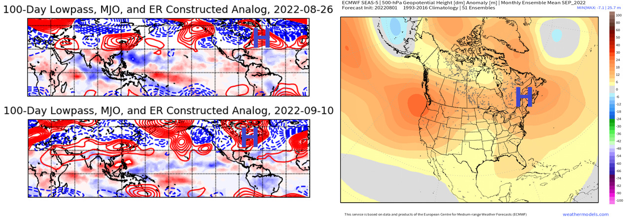
That means landfall risks are above normal for Florida over the next few months, and there are some shadows on the cave wall favoring a worrisome steering regime in September. As ever, it would be surprising to get through the next 10 weeks without at least some major tropical intrigue for Florida or the rest of the continental U.S. So, be prepared for whiplash when the quiet regime ends, and don’t be shocked if August plays to its demotivational strengths by the end of the month.
Some analog and long-range modeling indicates that blocking may start to develop over the western Atlantic in the last week of August, and blossom over the Great Lakes through the first half of September. This would be a worrisome steering pattern for the historically most active weeks of hurricane season, should it indeed develop.
That means landfall risks are above normal for Florida over the next few months, and there are some shadows on the cave wall favoring a worrisome steering regime in September. As ever, it would be surprising to get through the next 10 weeks without at least some major tropical intrigue for Florida or the rest of the continental U.S. So, be prepared for whiplash when the quiet regime ends, and don’t be shocked if August plays to its demotivational strengths by the end of the month.
6 likes
-
weeniepatrol
- Category 3
- Posts: 857
- Joined: Sat Aug 22, 2020 5:30 pm
- Location: WA State
Re: 2022 Indicators (SSTs/SAL/MSLP/Shear/Steering/Instability) and >Day 16 Models
weeniepatrol wrote:https://twitter.com/philklotzbach/status/1557508180380225536
Average ACE of these years is 162.7. Subtract 2009 because obviously we are not in a Strong El Nino and this rises to 176.4.
2 likes
Who is online
Users browsing this forum: CFLHurricane, cycloneye, SteveM, tolakram, zzzh and 139 guests