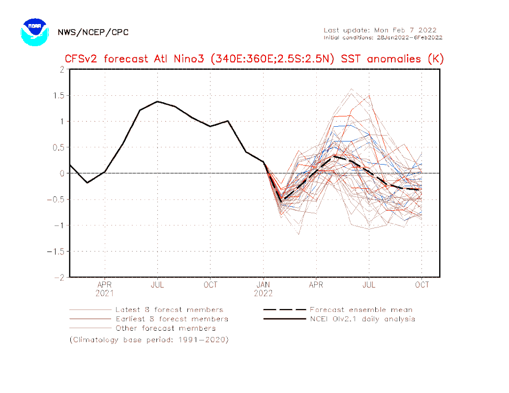
2022 Indicators (SSTs/SAL/MSLP/Shear/Steering/Instability) and >Day 16 Models

This is the general tropical discussion area. Anyone can take their shot at predicting a storms path.

Moderator: S2k Moderators

Forum rules

The posts in this forum are NOT official forecasts and should not be used as such. They are just the opinion of the poster and may or may not be backed by sound meteorological data. They are NOT endorsed by any professional institution or STORM2K. For official information, please refer to products from the National Hurricane Center and National Weather Service.

Help Support Storm2K
Message
Author
User avatar
SFLcane
S2K Supporter
S2K Supporter
Posts: 9606
Age: 46
Joined: Sat Jun 05, 2010 1:44 pm
Location: Lake Worth Florida

Re: 2022 indicators: SSTs / SAL / MSLP / shear / steering / instability / images

#61 Postby SFLcane » Mon Feb 07, 2022 12:50 pm

NotSparta wrote:
SFLcane wrote:New NMME precip with some Irma like tracks. :eek:

Quite the classic look I must say

Did a rather good job picking up those southern tracks into the Caribbean last year.

https://i.postimg.cc/BQxYZbYP/2109-F956-AE87-474-A-8843-7-FB65-C1-F8-AE6.jpg

https://i.postimg.cc/RVkWdV4d/5-B5-EB448-E251-4-A4-D-9272-34031650-C2-E5.jpg


Just remember, it is February so these models are subject to a lot of change. Have the SPB to get through and climate models have a lot of trouble with that. Wonder if they see the coming +NAO as well. That could knock the MDR SSTs down a notch


It did extremely well picking up those southerly tracks into the Caribbean last season. But yea off course proceed with caution but the classic look is still rather interesting.
0 likes   

User avatar
Category5Kaiju
Category 5
Category 5
Posts: 3357
Age: 22
Joined: Thu Dec 24, 2020 12:45 pm
Location: Seattle

Re: 2022 indicators: SSTs / SAL / MSLP / shear / steering / instability / images

#62 Postby Category5Kaiju » Mon Feb 07, 2022 4:44 pm

SFLcane wrote:New NMME precip with some Irma like tracks. :eek:

Quite the classic look I must say

Did a rather good job picking up those southern tracks into the Caribbean last year.

https://i.postimg.cc/BQxYZbYP/2109-F956-AE87-474-A-8843-7-FB65-C1-F8-AE6.jpg

https://i.postimg.cc/RVkWdV4d/5-B5-EB448-E251-4-A4-D-9272-34031650-C2-E5.jpg


After all, it is a List 2 year :D :eek:
0 likes   
Unless explicitly stated, all information covered in my posts is based on my opinions and observations. Please refer to a professional meteorologist or an accredited weather research agency otherwise, especially if serious decisions must be made in the event of a potentially life-threatening tropical storm or hurricane.

AlphaToOmega
Category 5
Category 5
Posts: 1448
Joined: Sat Jun 26, 2021 10:51 am
Location: Somewhere in Massachusetts

Re: 2022 indicators: SSTs / SAL / MSLP / shear / steering / instability / images

#63 Postby AlphaToOmega » Mon Feb 07, 2022 8:09 pm

Something else that is important to monitor will be the Atlantic Nino. If the Atlantic Nino is strongly positive, we would see an ITCZ suppressed to the south, preventing Caribbean development.

Image
1 likes   

User avatar
DorkyMcDorkface
Category 2
Category 2
Posts: 698
Age: 26
Joined: Mon Sep 30, 2019 1:32 pm
Location: Mid-Atlantic

Re: 2022 indicators: SSTs / SAL / MSLP / shear / steering / instability / images

#64 Postby DorkyMcDorkface » Mon Feb 07, 2022 8:46 pm

AlphaToOmega wrote:Something else that is important to monitor will be the Atlantic Nino. If the Atlantic Nino is strongly positive, we would see an ITCZ suppressed to the south, preventing Caribbean development.

https://i.postimg.cc/T12pd23t/atl3Mon.gif


Last year was really interesting regarding the Atlantic Niño phenomenon. It was at near record-breaking levels, so it really did seem to impact the season in a multitude of ways. Although it possibly played a role in handicapping late-season development as you mentioned (along with a generally unfavorable intraseasonal state) it appears it may have aided development earlier on in the year. We saw this with Elsa which developed in the Eastern Atlantic, a rarity in June/Early July. It's likely that the southerly latitude of the ITCZ ended up being beneficial in this case as the precursor TW was better shielded from the drier air that normally plagues the basin early in the season, and it also kept it over warmer SSTs. Also I think there was a bit of an Atlantic WWB generated as the MJO crossed paths with the "Niño" around that time as well.

Aside from that it appears the the warmth of the Atlantic Niño eventually began leaking northward into the MDR in time for ASO (WAM likely played a role in this as well). So I do agree that it's worth seeing how it pans out again this year, although one thing I'll say is that it'll likely be difficult for the equatorial Atlantic to reach that level of warmth again.

Image
5 likes   
Floyd 1999 | Isabel 2003 | Hanna 2008 | Irene 2011 | Sandy 2012 | Isaias 2020

User avatar
weeniepatrol
Category 3
Category 3
Posts: 857
Joined: Sat Aug 22, 2020 5:30 pm
Location: WA State

Re: 2022 indicators: SSTs / SAL / MSLP / shear / steering / instability / images

#65 Postby weeniepatrol » Tue Feb 08, 2022 12:40 am

Just once again emphasizing how classic the present warm AMO ring is:

Image

yadda yadda it's early, +nao, spring barrier, whatever. Things are already looking even more favorable than recent years if a robust nino fails to materialize (and there's only a few months now before Africa turns on, so good luck with that)
1 likes   

User avatar
weeniepatrol
Category 3
Category 3
Posts: 857
Joined: Sat Aug 22, 2020 5:30 pm
Location: WA State

Re: 2022 indicators: SSTs / SAL / MSLP / shear / steering / instability / images

#66 Postby weeniepatrol » Tue Feb 08, 2022 5:45 am

The MJO is emerging in the Indian Ocean, and it is forecast to gradually propagate eastward towards the Maritime Continent. Constructive interference with La Nina is beginning.. and the Pacific trades have returned.

Image

This and the warmth in the Atlantic tropics only serve to close the window for El Nino faster.

Maybe we'll finally get one next year.
0 likes   

User avatar
NotSparta
Professional-Met
Professional-Met
Posts: 1648
Age: 22
Joined: Fri Aug 18, 2017 8:24 am
Location: Naples, FL
Contact:

Re: 2022 indicators: SSTs / SAL / MSLP / shear / steering / instability / images

#67 Postby NotSparta » Tue Feb 08, 2022 8:13 am

weeniepatrol wrote:The MJO is emerging in the Indian Ocean, and it is forecast to gradually propagate eastward towards the Maritime Continent. Constructive interference with La Nina is beginning.. and the Pacific trades have returned.

https://i.imgur.com/3Ag7xpX.png

This and the warmth in the Atlantic tropics only serve to close the window for El Nino faster.

Maybe we'll finally get one next year.


I mean, MJO in this part of the world can very easily get to the WPAC and spark a WWB, I'd agree if that weren't to happen but we just don't know yet
1 likes   
This post was probably an opinion of mine, and in no way is official. Please refer to http://www.hurricanes.gov for official tropical analysis and advisories.

My website, with lots of tropical wx graphics, including satellite and recon: http://cyclonicwx.com

User avatar
SFLcane
S2K Supporter
S2K Supporter
Posts: 9606
Age: 46
Joined: Sat Jun 05, 2010 1:44 pm
Location: Lake Worth Florida

Re: 2022 indicators: SSTs / SAL / MSLP / shear / steering / instability / images

#68 Postby SFLcane » Tue Feb 08, 2022 8:33 am

weeniepatrol wrote:Just once again emphasizing how classic the present warm AMO ring is:

https://i.imgur.com/7BTSz4h.png

yadda yadda it's early, +nao, spring barrier, whatever. Things are already looking even more favorable than recent years if a robust nino fails to materialize (and there's only a few months now before Africa turns on, so good luck with that)


If it holds it will be active. Bank on it!
0 likes   

User avatar
SFLcane
S2K Supporter
S2K Supporter
Posts: 9606
Age: 46
Joined: Sat Jun 05, 2010 1:44 pm
Location: Lake Worth Florida

Re: 2022 indicators: SSTs / SAL / MSLP / shear / steering / instability / images

#69 Postby SFLcane » Tue Feb 08, 2022 9:06 am

weeniepatrol wrote:The MJO is emerging in the Indian Ocean, and it is forecast to gradually propagate eastward towards the Maritime Continent. Constructive interference with La Nina is beginning.. and the Pacific trades have returned.

https://i.imgur.com/3Ag7xpX.png

This and the warmth in the Atlantic tropics only serve to close the window for El Nino faster.

Maybe we'll finally get one next year.


The next couple weeks should feature enhanced trades. It's what comes after that will be interesting. If the MJO propagates into the Pacific we might get another WWB. If not, probably -ENSO or neutral for summer
0 likes   

User avatar
Yellow Evan
Professional-Met
Professional-Met
Posts: 15952
Age: 25
Joined: Fri Jul 15, 2011 12:48 pm
Location: Henderson, Nevada/Honolulu, HI
Contact:

Re: 2022 indicators: SSTs / SAL / MSLP / shear / steering / instability / images

#70 Postby Yellow Evan » Tue Feb 08, 2022 9:46 am

weeniepatrol wrote:The MJO is emerging in the Indian Ocean, and it is forecast to gradually propagate eastward towards the Maritime Continent. Constructive interference with La Nina is beginning.. and the Pacific trades have returned.

https://i.imgur.com/3Ag7xpX.png

This and the warmth in the Atlantic tropics only serve to close the window for El Nino faster.

Maybe we'll finally get one next year.


Way too soon to say the Nino door is closed. It’s early February, and the January WWB in itself has nearly killed off the Niña. Africa likely won’t be an issue if it even is until June. Three to four months is an eternity in meteorology. Even a warm neutral can make the deep tropics more hostile especially if the EPAC goes off.

Right now, ceiling is high for the 3 major NHEM basins which is exciting to think about.
5 likes   

User avatar
weeniepatrol
Category 3
Category 3
Posts: 857
Joined: Sat Aug 22, 2020 5:30 pm
Location: WA State

Re: 2022 indicators: SSTs / SAL / MSLP / shear / steering / instability / images

#71 Postby weeniepatrol » Tue Feb 08, 2022 2:39 pm

I would recommend checking your eyes to make sure that they are open.. not only is el nino looking less likely by the day, but La Nina is restrengthening in real-time! Atlantic MDR anomalous warmth relative to the rest of the global tropics is just yet another indication that it's not happening.

Image
1 likes   

tolakram
Admin
Admin
Posts: 19165
Age: 60
Joined: Sun Aug 27, 2006 8:23 pm
Location: Florence, KY (name is Mark)

Re: 2022 indicators: SSTs / SAL / MSLP / shear / steering / instability / images

#72 Postby tolakram » Tue Feb 08, 2022 2:47 pm

Every year we get lots of confidence from February to April, and every year people get burned and burned bad. Have fun predicting, but don't think for a second any of this is indicative of anything. Verification at this stage is almost completely random.
5 likes   
M a r k
- - - - -
Join us in chat: Storm2K Chatroom Invite. Android and IOS apps also available.

The posts in this forum are NOT official forecasts and should not be used as such. Posts are NOT endorsed by any professional institution or STORM2K.org. For official information and forecasts, please refer to NHC and NWS products.

User avatar
weeniepatrol
Category 3
Category 3
Posts: 857
Joined: Sat Aug 22, 2020 5:30 pm
Location: WA State

Re: 2022 indicators: SSTs / SAL / MSLP / shear / steering / instability / images

#73 Postby weeniepatrol » Tue Feb 08, 2022 2:48 pm

tolakram wrote:Every year we get lots of confidence from February to April, and every year people get burned and burned bad. Have fun predicting, but don't think for a second any of this is indicative of anything. Verification is almost completely random.


That's true and I won't pretend there's not a strong chance I'm one of them.
1 likes   

User avatar
SFLcane
S2K Supporter
S2K Supporter
Posts: 9606
Age: 46
Joined: Sat Jun 05, 2010 1:44 pm
Location: Lake Worth Florida

Re: 2022 indicators: SSTs / SAL / MSLP / shear / steering / instability / images

#74 Postby SFLcane » Tue Feb 08, 2022 2:53 pm

0 likes   

User avatar
SFLcane
S2K Supporter
S2K Supporter
Posts: 9606
Age: 46
Joined: Sat Jun 05, 2010 1:44 pm
Location: Lake Worth Florida

Re: 2022 indicators: SSTs / SAL / MSLP / shear / steering / instability / images

#75 Postby SFLcane » Tue Feb 08, 2022 2:55 pm

weeniepatrol wrote:I would recommend checking your eyes to make sure that they are open.. not only is el nino looking less likely by the day, but La Nina is restrengthening in real-time! Atlantic MDR anomalous warmth relative to the rest of the global tropics is just yet another indication that it's not happening.

https://i.imgur.com/vNcwug0.png


Well it's trying to propagate at the end there in March. What happens there will be critical.
0 likes   

User avatar
SFLcane
S2K Supporter
S2K Supporter
Posts: 9606
Age: 46
Joined: Sat Jun 05, 2010 1:44 pm
Location: Lake Worth Florida

Re: 2022 indicators: SSTs / SAL / MSLP / shear / steering / instability / images

#76 Postby SFLcane » Tue Feb 08, 2022 3:00 pm

0 likes   

User avatar
Yellow Evan
Professional-Met
Professional-Met
Posts: 15952
Age: 25
Joined: Fri Jul 15, 2011 12:48 pm
Location: Henderson, Nevada/Honolulu, HI
Contact:

Re: 2022 indicators: SSTs / SAL / MSLP / shear / steering / instability / images

#77 Postby Yellow Evan » Tue Feb 08, 2022 3:06 pm

weeniepatrol wrote:I would recommend checking your eyes to make sure that they are open.. not only is el nino looking less likely by the day, but La Nina is restrengthening in real-time! Atlantic MDR anomalous warmth relative to the rest of the global tropics is just yet another indication that it's not happening.

https://i.imgur.com/vNcwug0.png


https://cyclonicwx.com/data/sst/crw_sst ... nino34.png

There hasn’t been any re-strengthening of La Niña over a longer period of time (ie weeks). We’ve seen a slight cool down as estimated by satellite (which came after a substantial warm up of ENSO that lasted a month) but it can easily be undone and it’s not yet a long term trend. Westerly anomalies can still easily return with the right MJO setup come March or perhaps even April and wouldn’t be unprecedented. For past comparison, at this point in 1997, La Niña was still active.

Image

2006’s La Niña was peaking.

Image

Both Atlantic seasons would be fairly inactive (sub-80 ACE or so) due to El Niño.

I’m not saying a Nino is going to happen and even if it does, it will necessarily shut down the Atlantic. My point is right now all options are on the table.
1 likes   

User avatar
weeniepatrol
Category 3
Category 3
Posts: 857
Joined: Sat Aug 22, 2020 5:30 pm
Location: WA State

Re: 2022 indicators: SSTs / SAL / MSLP / shear / steering / instability / images

#78 Postby weeniepatrol » Tue Feb 08, 2022 3:30 pm

Yellow Evan wrote:I’m not saying a Nino is going to happen and even if it does, it will necessarily shut down the Atlantic. My point is right now all options are on the table.


The problem with your examples is that in both, the Atlantic was not as warm relative to global tropics as it is this year and furthermore, PDO was positive in both years whereas right now it is near record negative. These specifically are why the development of el nino are far less likely during this year than those and finally, there hasn't been a restrengthening of La Nina in recent weeks (note I used present tense) because the constructive interference has only just begun (but will, indeed, last for weeks) This time of year in 1997 featured the initiation of a robust downwelling KW, something that seems impossible to fathom happening now given the surge of enhanced trades now in place. If anything we will get the exact antithesis.. a robust upwelling Kelvin wave
0 likes   

User avatar
Yellow Evan
Professional-Met
Professional-Met
Posts: 15952
Age: 25
Joined: Fri Jul 15, 2011 12:48 pm
Location: Henderson, Nevada/Honolulu, HI
Contact:

Re: 2022 indicators: SSTs / SAL / MSLP / shear / steering / instability / images

#79 Postby Yellow Evan » Tue Feb 08, 2022 4:21 pm

weeniepatrol wrote:
Yellow Evan wrote:I’m not saying a Nino is going to happen and even if it does, it will necessarily shut down the Atlantic. My point is right now all options are on the table.


The problem with your examples is that in both, the Atlantic was not as warm relative to global tropics as it is this year and furthermore, PDO was positive in both years whereas right now it is near record negative. These specifically are why the development of el nino are far less likely during this year than those and finally, there hasn't been a restrengthening of La Nina in recent weeks (note I used present tense) because the constructive interference has only just begun (but will, indeed, last for weeks) This time of year in 1997 featured the initiation of a robust downwelling KW, something that seems impossible to fathom happening now given the surge of enhanced trades now in place. If anything we will get the exact antithesis.. a robust upwelling Kelvin wave


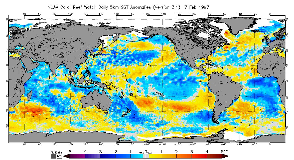
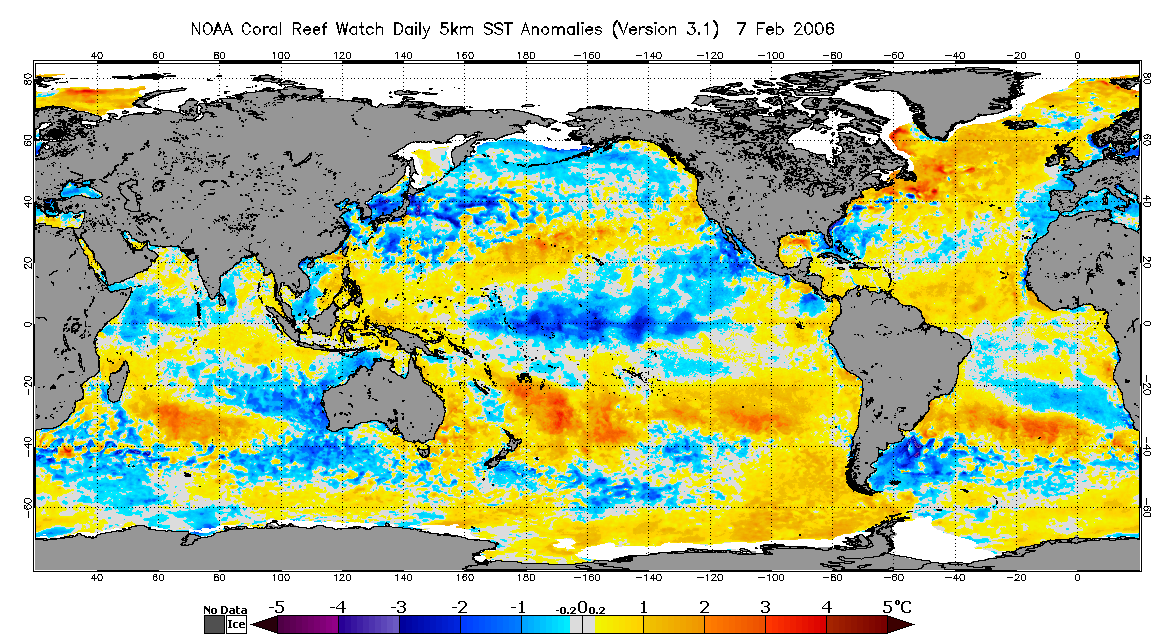
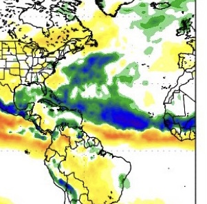
The Atlantic was above average with an established +AMO regime at this point in 1997 and 2006, although in 1997’s case, a distinct Atlantic Niña was evident by the equator. We also at least as of now (possible the trade pattern expected in February will create some sort of upwelling Kelvin Wave) have a downwelling Kelvin wave. Also worth noting that -PDO is at least being negated some recently by the ridging off the West Coast and troughing near the Aleutians, although realistically I still expect it to remain negative through the spring, just not at record levels that we saw this fall. The effect of the current enhanced easterlies will depend on how long it lasts. If it’s still there in early to mid March, then the Nino door begins to shut. March to May is really the critical time for changes in ENSO because that’s when the East to West Pacific gradient is the smallest, making ENSO more sensitive to changes.
4 likes   

User avatar
Category5Kaiju
Category 5
Category 5
Posts: 3357
Age: 22
Joined: Thu Dec 24, 2020 12:45 pm
Location: Seattle

Re: 2022 indicators: SSTs / SAL / MSLP / shear / steering / instability / images

#80 Postby Category5Kaiju » Tue Feb 08, 2022 4:49 pm


Obviously I've known how neutral conditions can still favor an active Atlantic like La Nina, but I genuinely did not know how close the NS and MH average count for both base states were. Especially with neutral actually favoring more NSs than La Nina on average during that timeframe.
0 likes   
Unless explicitly stated, all information covered in my posts is based on my opinions and observations. Please refer to a professional meteorologist or an accredited weather research agency otherwise, especially if serious decisions must be made in the event of a potentially life-threatening tropical storm or hurricane.


Return to “Talkin' Tropics”

Who is online

Users browsing this forum: JaviT and 230 guests