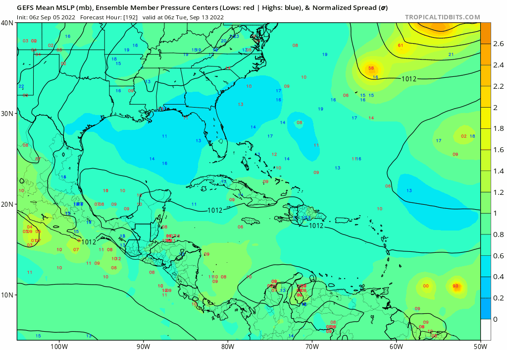
2022 Global Model Runs Discussion (Out thru day 16)

This is the general tropical discussion area. Anyone can take their shot at predicting a storms path.

Moderator: S2k Moderators

Forum rules

The posts in this forum are NOT official forecasts and should not be used as such. They are just the opinion of the poster and may or may not be backed by sound meteorological data. They are NOT endorsed by any professional institution or STORM2K. For official information, please refer to products from the National Hurricane Center and National Weather Service.

Help Support Storm2K
Message
Author
User avatar
DorkyMcDorkface
Category 2
Category 2
Posts: 709
Age: 26
Joined: Mon Sep 30, 2019 1:32 pm
Location: Mid-Atlantic

Re: 2022 Global Model Runs Discussion (Out thru day 16)

#2161 Postby DorkyMcDorkface » Sun Sep 04, 2022 7:00 pm

Iceresistance wrote:
aspen wrote:Euro and CMC are starting to latch onto a wave that’ll exit Africa around 9/11-9/13. The exact date differs between models and runs. The 12z Euro has its classic MDR/Africa bias and shows the wave developing over land.

Around the same time, the GFS and CMC show a disturbance over Central America that either goes into the EPac (GFS) or Gulf of Mexico (CMC).


12z EPS is going crazy with the 9/13 wave.

Thing is, Euro has a bias of essentially depicting strong TWs as near-TCs while still over Africa. So I'd take it with a grain of salt for now perhaps until a more realistic scenario is depicted, not to mention there's that "Africa barrier" which sometimes occurs when the EPS gets bullish for a wave about to emerge in a few days only to back off dramatically either prior to or right after it hits water.
Image
5 likes   
Floyd 1999 | Isabel 2003 | Hanna 2008 | Irene 2011 | Sandy 2012 | Isaias 2020

LarryWx
Category 5
Category 5
Posts: 5708
Joined: Sun Sep 07, 2003 2:04 pm
Location: GA

Re: 2022 Global Model Runs Discussion (Out thru day 16)

#2162 Postby LarryWx » Sun Sep 04, 2022 11:29 pm

LarryWx wrote:This is a new one on the 12Z UKMET fwiw, which is at a very low latitude moving WNW in the E MDR:


NEW TROPICAL CYCLONE FORECAST TO DEVELOP AFTER 120 HOURS
FORECAST POSITION AT T+120 : 9.8N 26.4W

LEAD CENTRAL MAXIMUM WIND
VERIFYING TIME TIME POSITION PRESSURE (MB) SPEED (KNOTS)
-------------- ---- -------- ------------- -------------
1200UTC 09.09.2022 120 9.8N 26.4W 1009 26
0000UTC 10.09.2022 132 10.6N 30.4W 1009 29
1200UTC 10.09.2022 144 11.4N 34.2W 1008 33


0Z UKMET is the 2nd run in a row with this far south latitude E MDR TC moving WNW. It appears to come off Africa ~Sep 7th and form into a TD on Sep 9th. The 0Z ICON has this as a weak low near 15N, 41W, moving WNW at hour 180 (12Z on 9/12). Keep in mind though that this ICON run also has a cat 4 Earl stuck under a ridge then moving WNW to NW near 68W:

NEW TROPICAL CYCLONE FORECAST TO DEVELOP AFTER 108 HOURS
FORECAST POSITION AT T+108 : 10.9N 25.0W

LEAD CENTRAL MAXIMUM WIND
VERIFYING TIME TIME POSITION PRESSURE (MB) SPEED (KNOTS)
-------------- ---- -------- ------------- -------------
1200UTC 09.09.2022 108 10.9N 25.0W 1009 27
0000UTC 10.09.2022 120 11.1N 29.1W 1008 30
1200UTC 10.09.2022 132 11.6N 32.8W 1007 32
0000UTC 11.09.2022 144 12.5N 36.1W 1007 33

 Edit: African satellite pics look unimpressive making me think this is probably a phantom TD on the UKMET.
0 likes   
Personal Forecast Disclaimer:
The posts in this forum are NOT official forecasts and should not be used as such. They are just the opinion of the poster and may or may not be backed by sound meteorological data. They are NOT endorsed by any professional institution or storm2k.org. For official information, please refer to the NHC and NWS products.

LarryWx
Category 5
Category 5
Posts: 5708
Joined: Sun Sep 07, 2003 2:04 pm
Location: GA

Re: 2022 Global Model Runs Discussion (Out thru day 16)

#2163 Postby LarryWx » Mon Sep 05, 2022 12:04 am

LarryWx wrote:
LarryWx wrote:This is a new one on the 12Z UKMET fwiw, which is at a very low latitude moving WNW in the E MDR:


NEW TROPICAL CYCLONE FORECAST TO DEVELOP AFTER 120 HOURS
FORECAST POSITION AT T+120 : 9.8N 26.4W

LEAD CENTRAL MAXIMUM WIND
VERIFYING TIME TIME POSITION PRESSURE (MB) SPEED (KNOTS)
-------------- ---- -------- ------------- -------------
1200UTC 09.09.2022 120 9.8N 26.4W 1009 26
0000UTC 10.09.2022 132 10.6N 30.4W 1009 29
1200UTC 10.09.2022 144 11.4N 34.2W 1008 33


0Z UKMET is the 2nd run in a row with this far south latitude E MDR TC moving WNW. It appears to come off Africa ~Sep 7th and form into a TD on Sep 9th. The 0Z ICON has this as a weak low near 15N, 41W, moving WNW at hour 180 (12Z on 9/12). Keep in mind though that this ICON run also has a cat 4 Earl stuck under a ridge then moving WNW to NW near 68W:

NEW TROPICAL CYCLONE FORECAST TO DEVELOP AFTER 108 HOURS
FORECAST POSITION AT T+108 : 10.9N 25.0W

LEAD CENTRAL MAXIMUM WIND
VERIFYING TIME TIME POSITION PRESSURE (MB) SPEED (KNOTS)
-------------- ---- -------- ------------- -------------
1200UTC 09.09.2022 108 10.9N 25.0W 1009 27
0000UTC 10.09.2022 120 11.1N 29.1W 1008 30
1200UTC 10.09.2022 132 11.6N 32.8W 1007 32
0000UTC 11.09.2022 144 12.5N 36.1W 1007 33

 Edit: African satellite pics look unimpressive making me think this is probably a phantom TD on the UKMET.


Fwiw, the 0Z GEFS is the most active run with this AEW that comes off Africa within 60-72 hours. Some of these members (5 of 31) get into or near the E Caribbean as a H 9/15-16. It will be interesting to see what happens with Earl if this actually ends up an active AEW as Earl's indirect effects on steering would be significant.
0 likes   
Personal Forecast Disclaimer:
The posts in this forum are NOT official forecasts and should not be used as such. They are just the opinion of the poster and may or may not be backed by sound meteorological data. They are NOT endorsed by any professional institution or storm2k.org. For official information, please refer to the NHC and NWS products.

User avatar
SFLcane
S2K Supporter
S2K Supporter
Posts: 9610
Age: 46
Joined: Sat Jun 05, 2010 1:44 pm
Location: Lake Worth Florida

Re: 2022 Global Model Runs Discussion (Out thru day 16)

#2164 Postby SFLcane » Mon Sep 05, 2022 8:35 am

LarryWx wrote:
LarryWx wrote:
LarryWx wrote:This is a new one on the 12Z UKMET fwiw, which is at a very low latitude moving WNW in the E MDR:


NEW TROPICAL CYCLONE FORECAST TO DEVELOP AFTER 120 HOURS
FORECAST POSITION AT T+120 : 9.8N 26.4W

LEAD CENTRAL MAXIMUM WIND
VERIFYING TIME TIME POSITION PRESSURE (MB) SPEED (KNOTS)
-------------- ---- -------- ------------- -------------
1200UTC 09.09.2022 120 9.8N 26.4W 1009 26
0000UTC 10.09.2022 132 10.6N 30.4W 1009 29
1200UTC 10.09.2022 144 11.4N 34.2W 1008 33


0Z UKMET is the 2nd run in a row with this far south latitude E MDR TC moving WNW. It appears to come off Africa ~Sep 7th and form into a TD on Sep 9th. The 0Z ICON has this as a weak low near 15N, 41W, moving WNW at hour 180 (12Z on 9/12). Keep in mind though that this ICON run also has a cat 4 Earl stuck under a ridge then moving WNW to NW near 68W:

NEW TROPICAL CYCLONE FORECAST TO DEVELOP AFTER 108 HOURS
FORECAST POSITION AT T+108 : 10.9N 25.0W

LEAD CENTRAL MAXIMUM WIND
VERIFYING TIME TIME POSITION PRESSURE (MB) SPEED (KNOTS)
-------------- ---- -------- ------------- -------------
1200UTC 09.09.2022 108 10.9N 25.0W 1009 27
0000UTC 10.09.2022 120 11.1N 29.1W 1008 30
1200UTC 10.09.2022 132 11.6N 32.8W 1007 32
0000UTC 11.09.2022 144 12.5N 36.1W 1007 33

 Edit: African satellite pics look unimpressive making me think this is probably a phantom TD on the UKMET.


Fwiw, the 0Z GEFS is the most active run with this AEW that comes off Africa within 60-72 hours. Some of these members (5 of 31) get into or near the E Caribbean as a H 9/15-16. It will be interesting to see what happens with Earl if this actually ends up an active AEW as Earl's indirect effects on steering would be significant.


We’ll…

Image
0 likes   

User avatar
SFLcane
S2K Supporter
S2K Supporter
Posts: 9610
Age: 46
Joined: Sat Jun 05, 2010 1:44 pm
Location: Lake Worth Florida

Re: 2022 Global Model Runs Discussion (Out thru day 16)

#2165 Postby SFLcane » Mon Sep 05, 2022 8:58 am

Image
0 likes   

User avatar
SFLcane
S2K Supporter
S2K Supporter
Posts: 9610
Age: 46
Joined: Sat Jun 05, 2010 1:44 pm
Location: Lake Worth Florida

Re: 2022 Global Model Runs Discussion (Out thru day 16)

#2166 Postby SFLcane » Mon Sep 05, 2022 9:01 am

That is the wave some GEFS members develop so it will be interesting to see what happens.
0 likes   

User avatar
kevin
Category 5
Category 5
Posts: 1769
Age: 25
Joined: Wed Aug 28, 2019 4:35 am

Re: 2022 Global Model Runs Discussion (Out thru day 16)

#2167 Postby kevin » Mon Sep 05, 2022 9:05 am

Besides Danielle and Earl most of the future action in the GEFS continues to come from the MDR with at least two separate waves. The second wave is further south and gets some members to the Caribbean and the US near the end of the run.

Image
0 likes   

User avatar
aspen
Category 5
Category 5
Posts: 8057
Joined: Sat Oct 12, 2019 7:10 pm
Location: Connecticut, USA

Re: 2022 Global Model Runs Discussion (Out thru day 16)

#2168 Postby aspen » Mon Sep 05, 2022 9:12 am

kevin wrote:Besides Danielle and Earl most of the future action in the GEFS continues to come from the MDR with at least two separate waves. The second wave is further south and gets some members to the Caribbean and the US near the end of the run.

https://i.imgur.com/PimFAF3.png

I count three waves on the GEFS and EPS: the 10/40 AOI, another much weaker wave that emerges sometime in the next few days, and a third that exits in about a week. Both also have ensemble support for a BoC system in 7-10 days…maybe third time’s the charm?
0 likes   
Irene '11 Sandy '12 Hermine '16 5/15/2018 Derecho Fay '20 Isaias '20 Elsa '21 Henri '21 Ida '21

I am only a meteorology enthusiast who knows a decent amount about tropical cyclones. Look to the professional mets, the NHC, or your local weather office for the best information.

User avatar
Category5Kaiju
Category 5
Category 5
Posts: 3361
Age: 22
Joined: Thu Dec 24, 2020 12:45 pm
Location: Seattle

Re: 2022 Global Model Runs Discussion (Out thru day 16)

#2169 Postby Category5Kaiju » Mon Sep 05, 2022 9:31 am

kevin wrote:Besides Danielle and Earl most of the future action in the GEFS continues to come from the MDR with at least two separate waves. The second wave is further south and gets some members to the Caribbean and the US near the end of the run.

https://i.imgur.com/PimFAF3.png


What a difference merely days can make in the tropics. Just several days ago, the models showed virtually nothing (not even the 10/40 AOI), making people really doubt the season. Now we're looking at the potential for 3 or so systems in the coming weeks. This is precisely why at least when it comes down to modeling, now-casting and relying only on one batch of models to determine the future (especially when trends aren't even looked at) is not a great idea. :lol:
8 likes   
Unless explicitly stated, all information covered in my posts is based on my opinions and observations. Please refer to a professional meteorologist or an accredited weather research agency otherwise, especially if serious decisions must be made in the event of a potentially life-threatening tropical storm or hurricane.

BobHarlem
Category 5
Category 5
Posts: 1665
Joined: Thu Oct 20, 2005 6:11 pm

Re: 2022 Global Model Runs Discussion (Out thru day 16)

#2170 Postby BobHarlem » Mon Sep 05, 2022 10:51 am

12z icon briefly spins up something in the gulf later this week.
0 likes   

User avatar
Hurricaneman
Category 5
Category 5
Posts: 7282
Age: 43
Joined: Tue Aug 31, 2004 3:24 pm
Location: central florida

Re: 2022 Global Model Runs Discussion (Out thru day 16)

#2171 Postby Hurricaneman » Mon Sep 05, 2022 11:23 am

The wave to come off Africa has a little support and the biggest plus I can see is it’s small compact nature so this one could be one to watch long term
0 likes   

User avatar
SFLcane
S2K Supporter
S2K Supporter
Posts: 9610
Age: 46
Joined: Sat Jun 05, 2010 1:44 pm
Location: Lake Worth Florida

Re: 2022 Global Model Runs Discussion (Out thru day 16)

#2172 Postby SFLcane » Mon Sep 05, 2022 12:02 pm

This is a robust wave. Gefs could be on to something.

Image
0 likes   

User avatar
aspen
Category 5
Category 5
Posts: 8057
Joined: Sat Oct 12, 2019 7:10 pm
Location: Connecticut, USA

Re: 2022 Global Model Runs Discussion (Out thru day 16)

#2173 Postby aspen » Mon Sep 05, 2022 12:06 pm

SFLcane wrote:This is a robust wave. Gefs could be on to something.

https://i.postimg.cc/K8nzWz0G/122-ACDDC-226-B-42-AD-A22-C-F1649-A5-E74-F0.gif

I think that’s the 9/6 wave the CMC and Euro turned into a long-tracking MDR hurricane before abruptly dropping it the other day. Neither of their most recent operation runs do much with it, but I think it’s also being picked up by the EPS.
0 likes   
Irene '11 Sandy '12 Hermine '16 5/15/2018 Derecho Fay '20 Isaias '20 Elsa '21 Henri '21 Ida '21

I am only a meteorology enthusiast who knows a decent amount about tropical cyclones. Look to the professional mets, the NHC, or your local weather office for the best information.

User avatar
SFLcane
S2K Supporter
S2K Supporter
Posts: 9610
Age: 46
Joined: Sat Jun 05, 2010 1:44 pm
Location: Lake Worth Florida

Re: 2022 Global Model Runs Discussion (Out thru day 16)

#2174 Postby SFLcane » Mon Sep 05, 2022 12:08 pm

aspen wrote:
SFLcane wrote:This is a robust wave. Gefs could be on to something.

https://i.postimg.cc/K8nzWz0G/122-ACDDC-226-B-42-AD-A22-C-F1649-A5-E74-F0.gif

I think that’s the 9/6 wave the CMC and Euro turned into a long-tracking MDR hurricane before abruptly dropping it the other day. Neither of their most recent operation runs do much with it, but I think it’s also being picked up by the EPS.


This mornings GEFS members that develop it are interesting.
0 likes   

LarryWx
Category 5
Category 5
Posts: 5708
Joined: Sun Sep 07, 2003 2:04 pm
Location: GA

Re: 2022 Global Model Runs Discussion (Out thru day 16)

#2175 Postby LarryWx » Mon Sep 05, 2022 1:19 pm

SFLcane wrote:
aspen wrote:
SFLcane wrote:This is a robust wave. Gefs could be on to something.

https://i.postimg.cc/K8nzWz0G/122-ACDDC-226-B-42-AD-A22-C-F1649-A5-E74-F0.gif

I think that’s the 9/6 wave the CMC and Euro turned into a long-tracking MDR hurricane before abruptly dropping it the other day. Neither of their most recent operation runs do much with it, but I think it’s also being picked up by the EPS.


This mornings GEFS members that develop it are interesting.


The 12Z GEFS, like the previous two runs, has a good number of strong members from this AEW coming off 9/7-8 with 8 of 31 that become hurricanes. The timing is slightly slower and the mean position a bit NE of the prior two runs meaning less threat to the NE Caribbean.

Is this just a phantom? I wouldn't bet against it, but we don't know yet. What are your latest thoughts? I saw that you think it looks rather impressive over Africa. I didn't see it that way at my last look, but sometimes that is hard to call.

The 12Z UKMET has it for the 3rd time albeit genesis is delayed til hour 144, meaning a 48 hour delay vs the prior two runs (phantom alert!) and still in a similarly pretty far south latitude in the MDR:

NEW TROPICAL CYCLONE FORECAST TO DEVELOP AFTER 144 HOURS
FORECAST POSITION AT T+144 : 12.5N 40.6W

LEAD CENTRAL MAXIMUM WIND
VERIFYING TIME TIME POSITION PRESSURE (MB) SPEED (KNOTS)
-------------- ---- -------- ------------- -------------
1200UTC 11.09.2022 144 12.5N 40.6W 1010 26
0 likes   
Personal Forecast Disclaimer:
The posts in this forum are NOT official forecasts and should not be used as such. They are just the opinion of the poster and may or may not be backed by sound meteorological data. They are NOT endorsed by any professional institution or storm2k.org. For official information, please refer to the NHC and NWS products.

User avatar
SFLcane
S2K Supporter
S2K Supporter
Posts: 9610
Age: 46
Joined: Sat Jun 05, 2010 1:44 pm
Location: Lake Worth Florida

Re: 2022 Global Model Runs Discussion (Out thru day 16)

#2176 Postby SFLcane » Mon Sep 05, 2022 1:24 pm

Larry GEFS control has a hurricane Just north of the NE Caribbean islands.
0 likes   

Hurricane Mike
Category 2
Category 2
Posts: 562
Joined: Tue Apr 10, 2018 7:44 am

Re: 2022 Global Model Runs Discussion (Out thru day 16)

#2177 Postby Hurricane Mike » Mon Sep 05, 2022 2:09 pm

I would watch the wave leaving Africa in a day or two. The long-range GEFS like it as a west runner.
https://www.youtube.com/watch?v=iDfGvxDd5iw
0 likes   

LarryWx
Category 5
Category 5
Posts: 5708
Joined: Sun Sep 07, 2003 2:04 pm
Location: GA

Re: 2022 Global Model Runs Discussion (Out thru day 16)

#2178 Postby LarryWx » Mon Sep 05, 2022 2:23 pm

SFLcane wrote:Larry GEFS control has a hurricane Just north of the NE Caribbean islands.


It looks like the 12Z GEFS control (assuming I'm looking at the right member) plunges down to 939 mb SW of Bermuda on 9/20!

Meanwhile, the 12Z Euro has this as a very weak low moving W to WNW at 21N, 57W at hour 240 as of 12Z on 9/15. If this were to be near reality and then develop, it would subsequently probably become a threat to the western basin near 9/18-9/20. You can see that the run slides a rather strong surface/H5 high westward to its north throughout the preceding 7 days keeping it from recurving early and instead taking it toward the western Atlantic:

Image

The 0Z Euro also had it albeit also as a very weak low.
0 likes   
Personal Forecast Disclaimer:
The posts in this forum are NOT official forecasts and should not be used as such. They are just the opinion of the poster and may or may not be backed by sound meteorological data. They are NOT endorsed by any professional institution or storm2k.org. For official information, please refer to the NHC and NWS products.

User avatar
Emmett_Brown
Category 5
Category 5
Posts: 1343
Joined: Wed Aug 24, 2005 9:10 pm
Location: Sarasota FL

Re: 2022 Global Model Runs Discussion (Out thru day 16)

#2179 Postby Emmett_Brown » Mon Sep 05, 2022 2:34 pm

Euro, Icon, Navgem, CMC all have a weak area of low pressure over the northern GOM by the end of the week. A few GFS ensemble members show a weak low as well. None of the models develops it much. Shear from an upper level trough should prevent anything big from developing, but the shear may actually help a weak storm to form, so I'm keeping an eye on it.
0 likes   

LarryWx
Category 5
Category 5
Posts: 5708
Joined: Sun Sep 07, 2003 2:04 pm
Location: GA

Re: 2022 Global Model Runs Discussion (Out thru day 16)

#2180 Postby LarryWx » Mon Sep 05, 2022 3:00 pm

SFLcane wrote:Larry GEFS control has a hurricane Just north of the NE Caribbean islands.


The 12Z EPS looks a bit menacing with this AEW position at 240, especially considering the high to the north moving west with this. The highest concentration of members with surface lows is right where the 12Z Euro op is at 240. Note that a number of members that earlier in the run were moving WNW curl back to a westerly heading. That is a recipe to bring AEWs into the western basin.

This run has ~40% of its members with surface lows from this AEW. The prior run had ~60%. So, a tick down fwiw.
1 likes   
Personal Forecast Disclaimer:
The posts in this forum are NOT official forecasts and should not be used as such. They are just the opinion of the poster and may or may not be backed by sound meteorological data. They are NOT endorsed by any professional institution or storm2k.org. For official information, please refer to the NHC and NWS products.


Return to “Talkin' Tropics”

Who is online

Users browsing this forum: cainjamin, cycloneye, NotSparta, Stratton23, weeniepatrol, zzzh and 156 guests