2022 Global Model Runs Discussion (Out thru day 16)

This is the general tropical discussion area. Anyone can take their shot at predicting a storms path.

Moderator: S2k Moderators

Forum rules

The posts in this forum are NOT official forecasts and should not be used as such. They are just the opinion of the poster and may or may not be backed by sound meteorological data. They are NOT endorsed by any professional institution or STORM2K. For official information, please refer to products from the National Hurricane Center and National Weather Service.

Help Support Storm2K
Message
Author
jlauderdal
S2K Supporter
S2K Supporter
Posts: 6771
Joined: Wed May 19, 2004 5:46 am
Location: NE Fort Lauderdale
Contact:

Re: 2022 Global Model Runs Discussion (Out thru day 16)

#2561 Postby jlauderdal » Sun Nov 13, 2022 6:51 am

gatorcane wrote:A little more defined on the 18Z GFS also going out to the very long-range. A bit rare to have a tropical wave make it that far west at that latitude this time of year:

https://i.postimg.cc/XqbMPjxW/gfs-z850-vort-watl-fh192-300.gif

It is late, but this is a "late" year, as we discussed a few months ago on the board....late November is way late but the "hurricane season" goes until the end of the month.
0 likes   

User avatar
Tampa Bay Hurricane
Category 5
Category 5
Posts: 5594
Age: 36
Joined: Fri Jul 22, 2005 7:54 pm
Location: St. Petersburg, FL

Re: 2022 Global Model Runs Discussion (Out thru day 16)

#2562 Postby Tampa Bay Hurricane » Sun Nov 13, 2022 8:05 am

Gfs and euro form a low in the gulf of 40 to 50 knots in the central gulf next Sunday and bring it east to the Florida peninsula- maybe a hybrid tropical system? Can’t get the image to upload my phone is messing up- but on both 6z gfs and 00z euro it’s there next Sunday.
0 likes   

tolakram
Admin
Admin
Posts: 19134
Age: 60
Joined: Sun Aug 27, 2006 8:23 pm
Location: Florence, KY (name is Mark)

Re: 2022 Global Model Runs Discussion (Out thru day 16)

#2563 Postby tolakram » Sun Nov 13, 2022 8:39 am

Tampa Bay Hurricane wrote:Gfs and euro form a low in the gulf of 40 to 50 knots in the central gulf next Sunday and bring it east to the Florida peninsula- maybe a hybrid tropical system? Can’t get the image to upload my phone is messing up- but on both 6z gfs and 00z euro it’s there next Sunday.


I assume non tropical. Very strong upper level winds.

Image
1 likes   
M a r k
- - - - -
Join us in chat: Storm2K Chatroom Invite. Android and IOS apps also available.

The posts in this forum are NOT official forecasts and should not be used as such. Posts are NOT endorsed by any professional institution or STORM2K.org. For official information and forecasts, please refer to NHC and NWS products.

User avatar
wxman57
Moderator-Pro Met
Moderator-Pro Met
Posts: 22472
Age: 66
Joined: Sat Jun 21, 2003 8:06 pm
Location: Houston, TX (southwest)

Re: 2022 Global Model Runs Discussion (Out thru day 16)

#2564 Postby wxman57 » Sun Nov 13, 2022 8:42 am

Typical, non-tropical west Gulf low may develop along the cold front next weekend. I think we've likely seen the last tropical system of the season.
1 likes   

User avatar
MetroMike
Category 3
Category 3
Posts: 823
Joined: Sun Aug 29, 2004 8:13 pm
Location: Tampa Bay
Contact:

Re: 2022 Global Model Runs Discussion (Out thru day 16)

#2565 Postby MetroMike » Sun Nov 13, 2022 9:45 am

wxman57 wrote:Typical, non-tropical west Gulf low may develop along the cold front next weekend. I think we've likely seen the last tropical system of the season.


Like others here have said this is a delayed season and the pattern we are in is rare and you can’t count it out even in December unless you have a bet of no more named systems with someone :cheesy:
4 likes   

Category5Kaiju
Category 5
Category 5
Posts: 3344
Age: 22
Joined: Thu Dec 24, 2020 12:45 pm
Location: Seattle

Re: 2022 Global Model Runs Discussion (Out thru day 16)

#2566 Postby Category5Kaiju » Sun Nov 13, 2022 10:24 am

MetroMike wrote:
wxman57 wrote:Typical, non-tropical west Gulf low may develop along the cold front next weekend. I think we've likely seen the last tropical system of the season.


Like others here have said this is a delayed season and the pattern we are in is rare and you can’t count it out even in December unless you have a bet of no more named systems with someone :cheesy:


Yeah agreed; under normal circumstances, I would be completely on board with agreeing with wxman57 without hesitation. However, this year has been anything but normal, and I personally wouldn't be shocked if we see at least 2 more NSs before the end of this year, even if they are weak and insignificant.
2 likes   
Unless explicitly stated, all information covered in my posts is based on my opinions and observations. Please refer to a professional meteorologist or an accredited weather research agency otherwise, especially if serious decisions must be made in the event of a potentially life-threatening tropical storm or hurricane.

LarryWx
Category 5
Category 5
Posts: 5686
Joined: Sun Sep 07, 2003 2:04 pm
Location: GA

Re: 2022 Global Model Runs Discussion (Out thru day 16)

#2567 Postby LarryWx » Sun Nov 13, 2022 11:29 am

Climo says that it is too late in the season for anything to form in the Gulf. However, it also says that there's a lingering slight chance that something will form in the SW Caribbean in any one season in mid to late November, especially in La Niña. The 2016 La Niña season had Otto form on November 20th there and he became a MH that impacted Central America.

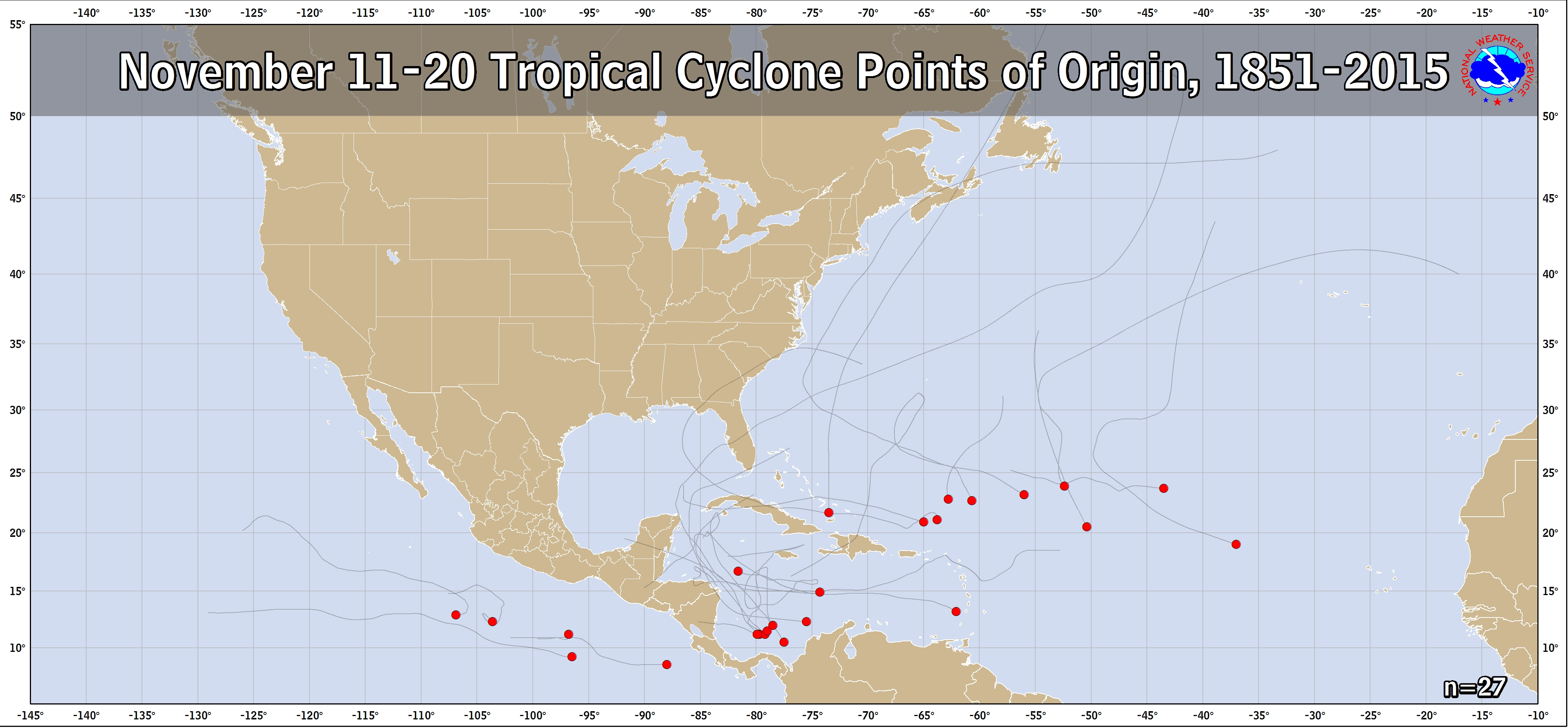
Fwiw, the 12Z GFS is the 4th run in a row with a TCG in the SW Caribbean this weekend. The 12Z CMC also has a low but it stays very weak. The 12Z ICON, 0Z Euro, and 0Z UKMET have (virtually) nothing. So, it may very well be just convective feedback on the GFS. For now, I'm keeping this as a nonzero but only slight chance. Posted below is the link for formations and tracks for November 11th-20th for the period 1851-2015..adding 2016's Otto to this makes 8 in the SW Caribbean or one every 21 years on average to form there then. Just considering La Niña seasons, I'd wild guess it at closer to about one every ten there. So, if there's going to be a mid November TCG, that would be the most likely location:

https://www.nhc.noaa.gov/climo/images/nov_11_20.png

Edit:
Mid-November La Niña TCG in SW Caribbean since 1851:
-Otto 2016
-Laura 1971
-#20 of 1933
-#15 of 1916

Per Eric Webb's tables, there have been ~46 La Niña seasons since 1851. So, 4/46 or once every eleven La Niña seasons has had a mid-November SW Caribbean TCG. So, a small but nontrivial chance.

---------------

The 12Z GEFS is one of the most active in the SW Caribbean this weekend with several members as hurricanes or strong TSs.
3 likes   
Personal Forecast Disclaimer:
The posts in this forum are NOT official forecasts and should not be used as such. They are just the opinion of the poster and may or may not be backed by sound meteorological data. They are NOT endorsed by any professional institution or storm2k.org. For official information, please refer to the NHC and NWS products.

Category5Kaiju
Category 5
Category 5
Posts: 3344
Age: 22
Joined: Thu Dec 24, 2020 12:45 pm
Location: Seattle

Re: 2022 Global Model Runs Discussion (Out thru day 16)

#2568 Postby Category5Kaiju » Mon Nov 14, 2022 8:58 am

GFS is hinting at a weak TS that hits Central America around the 20th. It's been fairly consistent with this idea, and given how the GFS correctly predicted Nicole and Lisa waaay in advance, I wouldn't be surprised if its good track record allows it to be correct again this time around
2 likes   
Unless explicitly stated, all information covered in my posts is based on my opinions and observations. Please refer to a professional meteorologist or an accredited weather research agency otherwise, especially if serious decisions must be made in the event of a potentially life-threatening tropical storm or hurricane.

LarryWx
Category 5
Category 5
Posts: 5686
Joined: Sun Sep 07, 2003 2:04 pm
Location: GA

Re: 2022 Global Model Runs Discussion (Out thru day 16)

#2569 Postby LarryWx » Mon Nov 14, 2022 7:41 pm

Category5Kaiju wrote:GFS is hinting at a weak TS that hits Central America around the 20th. It's been fairly consistent with this idea, and given how the GFS correctly predicted Nicole and Lisa waaay in advance, I wouldn't be surprised if its good track record allows it to be correct again this time around


Today's 18Z GFS/GEFS still has it, but other models still have at most only a very weak low. So, I'm keeping it in the back of my mind mainly because it is showing it in the SW Caribbean, but only as a small chance due to the lack of outside support and climo, which says only small chance (~10% in La Nina). If other models were to suddenly join in, that would surely get my attention and I'd raise the chance in my mind.
1 likes   
Personal Forecast Disclaimer:
The posts in this forum are NOT official forecasts and should not be used as such. They are just the opinion of the poster and may or may not be backed by sound meteorological data. They are NOT endorsed by any professional institution or storm2k.org. For official information, please refer to the NHC and NWS products.

User avatar
Gums
S2K Supporter
S2K Supporter
Posts: 148
Joined: Sun Oct 07, 2018 7:30 pm
Location: Niceville, FL

Re: 2022 Global Model Runs Discussion (Out thru day 16)

#2570 Postby Gums » Tue Nov 15, 2022 9:41 am

Salute!

The gulf low coming thru the Panhandle now and much weaker than Monday when near La/Ms. NWS feels it will get even weaker before coasting.

Gums sends...
0 likes   

User avatar
GCANE
S2K Supporter
S2K Supporter
Posts: 10787
Joined: Mon Oct 22, 2007 8:03 am

Re: 2022 Global Model Runs Discussion (Out thru day 16)

#2571 Postby GCANE » Wed Nov 16, 2022 7:06 am

Latest GFS forecasting a GoM surface low coming off a front next Tuesday.
Forecast is for it to be a warm-core, likely tropical system.
Makes sense, since a front creates a convergence of high CAPE air in the GoM.

https://moe.met.fsu.edu/cyclonephase/gf ... 6/171.html
1 likes   

User avatar
Hurricane2022
Category 3
Category 3
Posts: 876
Joined: Tue Aug 23, 2022 11:38 pm
Location: Araçatuba, Brazil

Re: 2022 Global Model Runs Discussion (Out thru day 16)

#2572 Postby Hurricane2022 » Wed Nov 16, 2022 8:33 am

Interesting that GFS forms a hurricane in the WCAR...

...In December :spam:
I love mr. GFS :lol:
0 likes   
For reliable and detailed information for any meteorological phenomenon, please consult the National Hurricane Center, Joint Typhoon Warning Center , or your local Meteo Center.
Sorry for the bad English sometimes!!!

Category5Kaiju
Category 5
Category 5
Posts: 3344
Age: 22
Joined: Thu Dec 24, 2020 12:45 pm
Location: Seattle

Re: 2022 Global Model Runs Discussion (Out thru day 16)

#2573 Postby Category5Kaiju » Wed Nov 16, 2022 8:50 am

Hurricane2022 wrote:Interesting that GFS forms a hurricane in the WCAR...

...In December :spam:
I love mr. GFS :lol:


A major hurricane in the WCAR in December would be a very 2022 thing to do tho, given how weird this season has tended to behave lol
1 likes   
Unless explicitly stated, all information covered in my posts is based on my opinions and observations. Please refer to a professional meteorologist or an accredited weather research agency otherwise, especially if serious decisions must be made in the event of a potentially life-threatening tropical storm or hurricane.

User avatar
GCANE
S2K Supporter
S2K Supporter
Posts: 10787
Joined: Mon Oct 22, 2007 8:03 am

Re: 2022 Global Model Runs Discussion (Out thru day 16)

#2574 Postby GCANE » Wed Nov 16, 2022 10:17 am

06z Euro in onboard for a possibility in the GoM this weekend.
0 likes   

tolakram
Admin
Admin
Posts: 19134
Age: 60
Joined: Sun Aug 27, 2006 8:23 pm
Location: Florence, KY (name is Mark)

Re: 2022 Global Model Runs Discussion (Out thru day 16)

#2575 Postby tolakram » Wed Nov 16, 2022 10:22 am

Euro also shows 60+ kts of upper level winds. I don't think this is tropical.

Image
2 likes   
M a r k
- - - - -
Join us in chat: Storm2K Chatroom Invite. Android and IOS apps also available.

The posts in this forum are NOT official forecasts and should not be used as such. Posts are NOT endorsed by any professional institution or STORM2K.org. For official information and forecasts, please refer to NHC and NWS products.

Category5Kaiju
Category 5
Category 5
Posts: 3344
Age: 22
Joined: Thu Dec 24, 2020 12:45 pm
Location: Seattle

Re: 2022 Global Model Runs Discussion (Out thru day 16)

#2576 Postby Category5Kaiju » Wed Nov 16, 2022 12:13 pm

Here we go, GFS about to generate the strongest December hurricane the Atlantic has ever seen :lol:
0 likes   
Unless explicitly stated, all information covered in my posts is based on my opinions and observations. Please refer to a professional meteorologist or an accredited weather research agency otherwise, especially if serious decisions must be made in the event of a potentially life-threatening tropical storm or hurricane.

User avatar
GCANE
S2K Supporter
S2K Supporter
Posts: 10787
Joined: Mon Oct 22, 2007 8:03 am

Re: 2022 Global Model Runs Discussion (Out thru day 16)

#2577 Postby GCANE » Wed Nov 16, 2022 12:19 pm

12Z GFS develops the GoM system a bit later, around Tuesday.
It's forecast to sit on the periphery of an ARWB centered in the W Carib with a half-way good 355K PV for development.

https://www.tropicaltidbits.com/analysi ... atl_25.png
0 likes   

User avatar
Teban54
Category 5
Category 5
Posts: 1903
Joined: Sat May 19, 2018 1:19 pm

Re: 2022 Global Model Runs Discussion (Out thru day 16)

#2578 Postby Teban54 » Wed Nov 16, 2022 1:18 pm

Category5Kaiju wrote:Here we go, GFS about to generate the strongest December hurricane the Atlantic has ever seen :lol:

GFS really wants Owen to be a carbon copy of Otto, the name it replaced...
0 likes   

LarryWx
Category 5
Category 5
Posts: 5686
Joined: Sun Sep 07, 2003 2:04 pm
Location: GA

Re: 2022 Global Model Runs Discussion (Out thru day 16)

#2579 Postby LarryWx » Wed Nov 16, 2022 1:30 pm

LarryWx wrote:
Category5Kaiju wrote:GFS is hinting at a weak TS that hits Central America around the 20th. It's been fairly consistent with this idea, and given how the GFS correctly predicted Nicole and Lisa waaay in advance, I wouldn't be surprised if its good track record allows it to be correct again this time around


Today's 18Z GFS/GEFS still has it, but other models still have at most only a very weak low. So, I'm keeping it in the back of my mind mainly because it is showing it in the SW Caribbean, but only as a small chance due to the lack of outside support and climo, which says only small chance (~10% in La Nina). If other models were to suddenly join in, that would surely get my attention and I'd raise the chance in my mind.


Followup: the 12Z GFS still has a weak surface low form in the SW Caribbean this weekend that gets down only to 1004 mb with no clearcut TCG vs a good number of stronger lows with actual TCG on some earlier runs. Other models continue to have no more than a very weak low. Climo says that if something were to form then, this would be about the most favored area in mid Nov with about a 10% chance. Based on all of the above, I think the chance for actual TCG this weekend down there is very low.
0 likes   
Personal Forecast Disclaimer:
The posts in this forum are NOT official forecasts and should not be used as such. They are just the opinion of the poster and may or may not be backed by sound meteorological data. They are NOT endorsed by any professional institution or storm2k.org. For official information, please refer to the NHC and NWS products.

User avatar
CourierPR
Category 5
Category 5
Posts: 1325
Age: 70
Joined: Tue Aug 31, 2004 7:53 pm
Location: Pompano Beach, Florida

Re: 2022 Global Model Runs Discussion (Out thru day 16)

#2580 Postby CourierPR » Wed Nov 16, 2022 1:56 pm

LarryWx wrote:
LarryWx wrote:
Category5Kaiju wrote:GFS is hinting at a weak TS that hits Central America around the 20th. It's been fairly consistent with this idea, and given how the GFS correctly predicted Nicole and Lisa waaay in advance, I wouldn't be surprised if its good track record allows it to be correct again this time around


Today's 18Z GFS/GEFS still has it, but other models still have at most only a very weak low. So, I'm keeping it in the back of my mind mainly because it is showing it in the SW Caribbean, but only as a small chance due to the lack of outside support and climo, which says only small chance (~10% in La Nina). If other models were to suddenly join in, that would surely get my attention and I'd raise the chance in my mind.


Followup: the 12Z GFS still has a weak surface low form in the SW Caribbean this weekend that gets down only to 1004 mb with no clearcut TCG vs a good number of stronger lows with actual TCG on some earlier runs. Other models continue to have no more than a very weak low. Climo says that if something were to form then, this would be about the most favored area in mid Nov with about a 10% chance. Based on all of the above, I think the chance for actual TCG this weekend down there is very low.


On what do you base that 10% figure?
0 likes   


Return to “Talkin' Tropics”

Who is online

Users browsing this forum: No registered users and 37 guests