2022 Global Model Runs Discussion (Out thru day 16)

This is the general tropical discussion area. Anyone can take their shot at predicting a storms path.

Moderator: S2k Moderators

Forum rules

The posts in this forum are NOT official forecasts and should not be used as such. They are just the opinion of the poster and may or may not be backed by sound meteorological data. They are NOT endorsed by any professional institution or STORM2K. For official information, please refer to products from the National Hurricane Center and National Weather Service.

Help Support Storm2K
Message
Author
LarryWx
Category 5
Category 5
Posts: 5686
Joined: Sun Sep 07, 2003 2:04 pm
Location: GA

Re: 2022 Global Model Runs Discussion (Out thru day 16)

#2581 Postby LarryWx » Wed Nov 16, 2022 2:10 pm

CourierPR wrote:
LarryWx wrote:
LarryWx wrote:
Today's 18Z GFS/GEFS still has it, but other models still have at most only a very weak low. So, I'm keeping it in the back of my mind mainly because it is showing it in the SW Caribbean, but only as a small chance due to the lack of outside support and climo, which says only small chance (~10% in La Nina). If other models were to suddenly join in, that would surely get my attention and I'd raise the chance in my mind.


Followup: the 12Z GFS still has a weak surface low form in the SW Caribbean this weekend that gets down only to 1004 mb with no clearcut TCG vs a good number of stronger lows with actual TCG on some earlier runs. Other models continue to have no more than a very weak low. Climo says that if something were to form then, this would be about the most favored area in mid Nov with about a 10% chance. Based on all of the above, I think the chance for actual TCG this weekend down there is very low.


On what do you base that 10% figure?


Mid-November La Niña TCG in SW Caribbean since 1851:
-Otto 2016
-Laura 1971
-#20 of 1933
-#15 of 1916

Per Eric Webb's tables, there have been ~46 La Niña seasons since 1851. So, 4/46 or once every eleven La Niña seasons has had a mid-November SW Caribbean TCG. So, a small but nontrivial chance.

Webb's ENSO data since 1850:
https://www.webberweather.com/ensemble- ... index.html

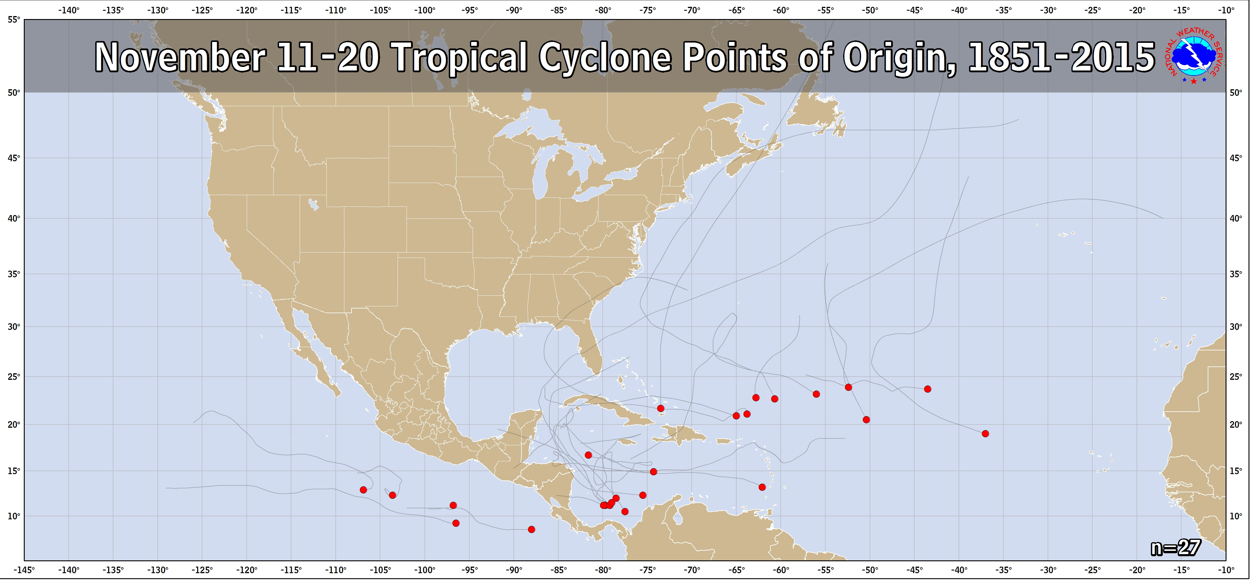
Mid November genesis locations 1851-2015 shows 7 TCGs in the SW Caribbean with 3 of these during La Nina: (need to add 2016's Otto to this to make 4 during La Nina):
https://www.nhc.noaa.gov/climo/images/nov_11_20.png

Past TC tracks by year from NHC archives:
https://www.nhc.noaa.gov/data/
5 likes   
Personal Forecast Disclaimer:
The posts in this forum are NOT official forecasts and should not be used as such. They are just the opinion of the poster and may or may not be backed by sound meteorological data. They are NOT endorsed by any professional institution or storm2k.org. For official information, please refer to the NHC and NWS products.

User avatar
Tampa Bay Hurricane
Category 5
Category 5
Posts: 5594
Age: 36
Joined: Fri Jul 22, 2005 7:54 pm
Location: St. Petersburg, FL

Re: 2022 Global Model Runs Discussion (Out thru day 16)

#2582 Postby Tampa Bay Hurricane » Wed Nov 16, 2022 4:06 pm

I know it’s not tropical but gfs and euro keep showing that cool looking winter type low in the gulf sweeping rain and some gusty winds towards the Florida peninsula next week. Both have it producing red on the precip depiction so heavy rains a good bet. Ever since hurricanes Ian and Nicole I’ve been weather obsessed with any low that comes near the Florida peninsula.
2 likes   

User avatar
Hurricane2022
Category 3
Category 3
Posts: 876
Joined: Tue Aug 23, 2022 11:38 pm
Location: Araçatuba, Brazil

Re: 2022 Global Model Runs Discussion (Out thru day 16)

#2583 Postby Hurricane2022 » Thu Nov 17, 2022 12:20 am

933 hPa in this run. Valid at December 02, TAU 378.
I don't even need to say which model showed this absurd :lol:
3 likes   
For reliable and detailed information for any meteorological phenomenon, please consult the National Hurricane Center, Joint Typhoon Warning Center , or your local Meteo Center.
Sorry for the bad English sometimes!!!

User avatar
kevin
Category 5
Category 5
Posts: 1764
Age: 25
Joined: Wed Aug 28, 2019 4:35 am

Re: 2022 Global Model Runs Discussion (Out thru day 16)

#2584 Postby kevin » Thu Nov 17, 2022 9:18 am

Hurricane2022 wrote:933 hPa in this run. Valid at December 02, TAU 378.
I don't even need to say which model showed this absurd :lol:


More than a 150 years of hurricane records in the Atlantic = there has never been a cat 2 or higher hurricane in December.
GFS = Yeah cat 4 or 5 sounds about right to me.
3 likes   

User avatar
Blown Away
S2K Supporter
S2K Supporter
Posts: 9854
Joined: Wed May 26, 2004 6:17 am

Re: 2022 Global Model Runs Discussion (Out thru day 16)

#2585 Postby Blown Away » Thu Nov 17, 2022 10:54 am

kevin wrote:
Hurricane2022 wrote:933 hPa in this run. Valid at December 02, TAU 378.
I don't even need to say which model showed this absurd :lol:


More than a 150 years of hurricane records in the Atlantic = there has never been a cat 2 or higher hurricane in December.
GFS = Yeah cat 4 or 5 sounds about right to me.


Image
00z GFS, one final GFS Cat 4/5 phantom model run for 2022. :D
1 likes   
Hurricane Eye Experience: David 79, Irene 99, Frances 04, Jeanne 04, Wilma 05...
Hurricane Brush Experience: Andrew 92, Erin 95, Floyd 99, Matthew 16, Irma 17, Ian 22, Nicole 22…

User avatar
Iceresistance
Category 5
Category 5
Posts: 8887
Age: 20
Joined: Sat Oct 10, 2020 9:45 am
Location: Tecumseh, OK/Norman, OK

Re: 2022 Global Model Runs Discussion (Out thru day 16)

#2586 Postby Iceresistance » Thu Nov 17, 2022 12:01 pm

The 12z GFS strikes again with a WCar Hurricane! :double:
1 likes   
Bill 2015 & Beta 2020

Winter 2020-2021 :cold:

All observations are in Tecumseh, OK unless otherwise noted.

Winter posts are focused mainly for Oklahoma & Texas.

Take any of my forecasts with a grain of salt, refer to the NWS, SPC, and NHC for official information

Never say Never with weather! Because ANYTHING is possible!

User avatar
Hurricane2022
Category 3
Category 3
Posts: 876
Joined: Tue Aug 23, 2022 11:38 pm
Location: Araçatuba, Brazil

Re: 2022 Global Model Runs Discussion (Out thru day 16)

#2587 Postby Hurricane2022 » Thu Nov 17, 2022 2:21 pm

Iceresistance wrote:The 12z GFS strikes again with a WCar Hurricane! :double:

It's still Long-Range. Each round has a different intensity and route. I think the GFS should stop showing this phantom hurricane within the next 7 - 13 runs.
1 likes   
For reliable and detailed information for any meteorological phenomenon, please consult the National Hurricane Center, Joint Typhoon Warning Center , or your local Meteo Center.
Sorry for the bad English sometimes!!!

User avatar
Blown Away
S2K Supporter
S2K Supporter
Posts: 9854
Joined: Wed May 26, 2004 6:17 am

Re: 2022 Global Model Runs Discussion (Out thru day 16)

#2588 Postby Blown Away » Thu Nov 17, 2022 4:03 pm

Hurricane2022 wrote:
Iceresistance wrote:The 12z GFS strikes again with a WCar Hurricane! :double:

It's still Long-Range. Each round has a different intensity and route. I think the GFS should stop showing this phantom hurricane within the next 7 - 13 runs.


Image
12z GFS
1 likes   
Hurricane Eye Experience: David 79, Irene 99, Frances 04, Jeanne 04, Wilma 05...
Hurricane Brush Experience: Andrew 92, Erin 95, Floyd 99, Matthew 16, Irma 17, Ian 22, Nicole 22…

LarryWx
Category 5
Category 5
Posts: 5686
Joined: Sun Sep 07, 2003 2:04 pm
Location: GA

Re: 2022 Global Model Runs Discussion (Out thru day 16)

#2589 Postby LarryWx » Thu Nov 17, 2022 6:24 pm

kevin wrote:
Hurricane2022 wrote:933 hPa in this run. Valid at December 02, TAU 378.
I don't even need to say which model showed this absurd :lol:


More than a 150 years of hurricane records in the Atlantic = there has never been a cat 2 or higher hurricane in December.
GFS = Yeah cat 4 or 5 sounds about right to me.


Here's some more climo. Going back to 1851, there are only three TS formations in the SW Caribbean on record for after November 20th:

1. 12/4/2003: Odette later became a high end TS that crossed Hispaniola December 6th. Warm neutral ENSO.

2. On 11/21/1969, TS Martha was named. This moved SW and later became a cat 1 hurricane. It then weakened into a TS that made landfall on Panama on 11/24/1969, which is the only Panama landfall of a TS+ I've been able to find. Weak El Nino.

3. On 11/22/1862, TS #6 was born. It strengthened to a high end TS but hardly moved before dissipating on 11/25. Cold neutral ENSO
Last edited by LarryWx on Thu Nov 17, 2022 6:33 pm, edited 1 time in total.
3 likes   
Personal Forecast Disclaimer:
The posts in this forum are NOT official forecasts and should not be used as such. They are just the opinion of the poster and may or may not be backed by sound meteorological data. They are NOT endorsed by any professional institution or storm2k.org. For official information, please refer to the NHC and NWS products.

Nuno
Category 2
Category 2
Posts: 529
Joined: Fri Aug 30, 2019 8:35 am
Location: Coral Gables, FL

Re: 2022 Global Model Runs Discussion (Out thru day 16)

#2590 Postby Nuno » Thu Nov 17, 2022 6:32 pm

kevin wrote:
Hurricane2022 wrote:933 hPa in this run. Valid at December 02, TAU 378.
I don't even need to say which model showed this absurd :lol:


More than a 150 years of hurricane records in the Atlantic = there has never been a cat 2 or higher hurricane in December.
GFS = Yeah cat 4 or 5 sounds about right to me.


150 years is but a drop in a bucket of unrecorded climo lol. I know the GFS loves its phantoms but we already had an unusually active November, so why not? This is clearly a backloaded season. :ggreen:
0 likes   
Andrew (1992), Irene (1999), Frances (2004), Katrina (2005), Wilma (2005), Fay (2008), Irma (2017), Eta (2020), Ian (2022)

User avatar
Hurricane2022
Category 3
Category 3
Posts: 876
Joined: Tue Aug 23, 2022 11:38 pm
Location: Araçatuba, Brazil

Re: 2022 Global Model Runs Discussion (Out thru day 16)

#2591 Postby Hurricane2022 » Thu Nov 17, 2022 7:05 pm

In this 18Z run, the GFS presents the SW Caribbean system as a strong TS/Minimal C1 hitting Nicaragua, and shortly afterwards produces another C1 in the open Atlantic, reaching a minimum pressure of 975 hPa on TAU 384. Still very long-range , but I wouldn't rule out seeing something in the subtropics as well.

Note: If this GFS prediction comes true, we will have 10 hurricanes in the season total, with 7 of them reaching peak intensity as a Category 1 hurricane, with 5 being consecutive (Lisa - Paula), and with all of this happening in the months of November - December.
1 likes   
For reliable and detailed information for any meteorological phenomenon, please consult the National Hurricane Center, Joint Typhoon Warning Center , or your local Meteo Center.
Sorry for the bad English sometimes!!!

zzzh
Category 2
Category 2
Posts: 501
Joined: Thu Sep 02, 2021 1:13 pm

Re: 2022 Global Model Runs Discussion (Out thru day 16)

#2592 Postby zzzh » Thu Nov 17, 2022 9:11 pm

Image
ULAC over the West Caribbean on Nov. 25th :lol: Maybe something can actually form.
2 likes   

LarryWx
Category 5
Category 5
Posts: 5686
Joined: Sun Sep 07, 2003 2:04 pm
Location: GA

Re: 2022 Global Model Runs Discussion (Out thru day 16)

#2593 Postby LarryWx » Fri Nov 18, 2022 12:31 am

Blown Away wrote:
kevin wrote:
Hurricane2022 wrote:933 hPa in this run. Valid at December 02, TAU 378.
I don't even need to say which model showed this absurd :lol:


More than a 150 years of hurricane records in the Atlantic = there has never been a cat 2 or higher hurricane in December.
GFS = Yeah cat 4 or 5 sounds about right to me.


https://i.imgur.com/UAn9C3k.gif
00z GFS, one final GFS Cat 4/5 phantom model run for 2022. :D


Not final as 0Z 11/18/22 GFS had another. Is this the final? Nobody knows!
0 likes   
Personal Forecast Disclaimer:
The posts in this forum are NOT official forecasts and should not be used as such. They are just the opinion of the poster and may or may not be backed by sound meteorological data. They are NOT endorsed by any professional institution or storm2k.org. For official information, please refer to the NHC and NWS products.

User avatar
chaser1
S2K Supporter
S2K Supporter
Posts: 4664
Age: 62
Joined: Sat Oct 15, 2005 5:59 pm
Location: Longwood, Fl

Re: 2022 Global Model Runs Discussion (Out thru day 16)

#2594 Postby chaser1 » Fri Nov 18, 2022 12:31 am

Whew, so glad to see GFS get off it's acid tripping kick with some penchant toward threatening Central America with some 933 mb hurricane :lol: As of the 0Z forecast, GFS long range is now showing an evolution far more realistic. Like a 928 mb hurricane moving north toward Isle of Pines, and beginning a cross of W. Cuba and aiming toward the Florida Keys. Far more in line with reality :yow:
1 likes   
Personal Forecast Disclaimer:
The posts in this forum are NOT official forecast and should not be used as such. They are just the opinion of the poster and may or may not be backed by sound meteorological data. They are NOT endorsed by any professional institution or storm2k.org. For official information, please refer to the NHC and NWS products.


User avatar
Blown Away
S2K Supporter
S2K Supporter
Posts: 9854
Joined: Wed May 26, 2004 6:17 am

Re: 2022 Global Model Runs Discussion (Out thru day 16)

#2595 Postby Blown Away » Fri Nov 18, 2022 8:17 am

Image
00z GFS... Nothing like a Cat 4/5 heading towards Cuba/SFL on December 4th... GFS continues pushing back the timing so very very likely just model entertainment...
3 likes   
Hurricane Eye Experience: David 79, Irene 99, Frances 04, Jeanne 04, Wilma 05...
Hurricane Brush Experience: Andrew 92, Erin 95, Floyd 99, Matthew 16, Irma 17, Ian 22, Nicole 22…

Category5Kaiju
Category 5
Category 5
Posts: 3344
Age: 22
Joined: Thu Dec 24, 2020 12:45 pm
Location: Seattle

Re: 2022 Global Model Runs Discussion (Out thru day 16)

#2596 Postby Category5Kaiju » Fri Nov 18, 2022 8:53 am

Blown Away wrote:https://i.imgur.com/JbhuL2H.gif
00z GFS... Nothing like a Cat 4/5 heading towards Cuba/SFL on December 4th... GFS continues pushing back the timing so very very likely just model entertainment...


Actually what's funny is several previous runs had that thing officially "form" around November 30, that particular run seems like formation occurs on November 28-29ish. Very subtle difference though
0 likes   
Unless explicitly stated, all information covered in my posts is based on my opinions and observations. Please refer to a professional meteorologist or an accredited weather research agency otherwise, especially if serious decisions must be made in the event of a potentially life-threatening tropical storm or hurricane.

User avatar
Hurricane2022
Category 3
Category 3
Posts: 876
Joined: Tue Aug 23, 2022 11:38 pm
Location: Araçatuba, Brazil

Re: 2022 Global Model Runs Discussion (Out thru day 16)

#2597 Postby Hurricane2022 » Fri Nov 18, 2022 10:29 am

1 likes   
For reliable and detailed information for any meteorological phenomenon, please consult the National Hurricane Center, Joint Typhoon Warning Center , or your local Meteo Center.
Sorry for the bad English sometimes!!!

Category5Kaiju
Category 5
Category 5
Posts: 3344
Age: 22
Joined: Thu Dec 24, 2020 12:45 pm
Location: Seattle

Re: 2022 Global Model Runs Discussion (Out thru day 16)

#2598 Postby Category5Kaiju » Fri Nov 18, 2022 10:40 am


Let's also not forget that the W. Atlantic is currently significantly warmer than average (even the cold-biased CDAS shows that region of the ocean being orange and red lol), with the WCAR being 29 C (warm enough to theoretically support a Cat 5). It's understandable to believe that we won't get anything anytime soon and that Nicole was the last storm of the season. However, considering these precursor impulses exist, let alone the anomalous nature of this late season as a whole, I'm honestly going to sit back and not jump to prematurely concluding that everything is over just yet. Anomalies are anomalies for a reason. They defy what we see as standard in a given hurricane season.
2 likes   
Unless explicitly stated, all information covered in my posts is based on my opinions and observations. Please refer to a professional meteorologist or an accredited weather research agency otherwise, especially if serious decisions must be made in the event of a potentially life-threatening tropical storm or hurricane.

User avatar
chris_fit
Category 5
Category 5
Posts: 3078
Joined: Wed Sep 10, 2003 11:58 pm
Location: Tampa Bay Area, FL
Contact:

Re: 2022 Global Model Runs Discussion (Out thru day 16)

#2599 Postby chris_fit » Fri Nov 18, 2022 11:32 am

We simply have to inquire if @WXMAN57 has any vacations planned in the next 10-15 days. This is a tried, tested, and true indicator of tropical genesis.
8 likes   

User avatar
cycloneye
Admin
Admin
Posts: 138789
Age: 67
Joined: Thu Oct 10, 2002 10:54 am
Location: San Juan, Puerto Rico

Re: 2022 Global Model Runs Discussion (Out thru day 16)

#2600 Postby cycloneye » Fri Nov 18, 2022 11:48 am

1 likes   
Visit the Caribbean-Central America Weather Thread where you can find at first post web cams,radars
and observations from Caribbean basin members Click Here


Return to “Talkin' Tropics”

Who is online

Users browsing this forum: No registered users and 38 guests