2022 Global Model Runs Discussion (Out thru day 16)
Moderator: S2k Moderators
Forum rules

The posts in this forum are NOT official forecasts and should not be used as such. They are just the opinion of the poster and may or may not be backed by sound meteorological data. They are NOT endorsed by any professional institution or STORM2K. For official information, please refer to products from the National Hurricane Center and National Weather Service.
-
Kingarabian

- S2K Supporter

- Posts: 15432
- Joined: Sat Aug 08, 2009 3:06 am
- Location: Honolulu, Hawaii
Re: 2022 Global Model Runs Discussion (Out thru day 16)
Euro and CMC appear to be backing off further EPAC development after Howard.
2 likes
RIP Kobe Bryant
-
cycloneye

- Admin

- Posts: 139027
- Age: 67
- Joined: Thu Oct 10, 2002 10:54 am
- Location: San Juan, Puerto Rico
Re: 2022 Global Model Runs Discussion (Out thru day 16)
August 25. Is after the 20th date of the bell.

3 likes
Visit the Caribbean-Central America Weather Thread where you can find at first post web cams,radars
and observations from Caribbean basin members Click Here
and observations from Caribbean basin members Click Here
-
PTrackerLA

- Category 5

- Posts: 5248
- Age: 40
- Joined: Thu Oct 10, 2002 8:40 pm
- Location: Lafayette, LA
Re: 2022 Global Model Runs Discussion (Out thru day 16)
I have a gut feeling the models will come alive by next week as they all get into the August 20th-August 25th time frame. 12z GFS could be the first real sign, we'll see.
6 likes
-
mcheer23

- Professional-Met

- Posts: 423
- Age: 30
- Joined: Sun Jun 24, 2012 8:24 pm
- Location: Sugar Land, Texas
Re: 2022 Global Model Runs Discussion (Out thru day 16)
CPC has a moderate confidence of Tropical Development Aug 17-23rd
https://www.cpc.ncep.noaa.gov/products/precip/CWlink/ghazards/images/gth_full.png
https://www.cpc.ncep.noaa.gov/products/precip/CWlink/ghazards/images/gth_full.png
2 likes
-
SFLcane

- S2K Supporter
- Posts: 9606
- Age: 46
- Joined: Sat Jun 05, 2010 1:44 pm
- Location: Lake Worth Florida
Re: 2022 Global Model Runs Discussion (Out thru day 16)
mcheer23 wrote:CPC has a moderate confidence of Tropical Development Aug 17-23rd
https://www.cpc.ncep.noaa.gov/products/precip/CWlink/ghazards/images/gth_full.png
Wonder what that is based on?
0 likes

Re: 2022 Global Model Runs Discussion (Out thru day 16)
SFLcane wrote:mcheer23 wrote:CPC has a moderate confidence of Tropical Development Aug 17-23rd
https://www.cpc.ncep.noaa.gov/products/precip/CWlink/ghazards/images/gth_full.png
Wonder what that is based on?
Later in the period, one or more easterly waves propagating over West Africa remain favored in ensemble guidance, where there is also multi-model agreement indicating Rossby wave activity and enhanced convection in the OLR anomaly fields over the tropical Atlantic. While some probabilistic TC tools are less supportive of TC potential in the MDR, a moderate confidence area is posted over the MDR for week-2, which coincides with a sharp climatological uptick in TC activity over the Atlantic by mid-August. Should the MJO show better signs or organization over the Indian Ocean later in August, this also historically favors increased chances for TC development in the Atlantic basin.

In the Euro and GFS ensemble products, an uptick in MDR activity begins during the latter portion of week two.


3 likes
Kendall -> SLO -> PBC
Memorable Storms: Katrina (for its Florida landfall...) Wilma Matthew Irma
Memorable Storms: Katrina (for its Florida landfall...) Wilma Matthew Irma
-
Blown Away

- S2K Supporter
- Posts: 9861
- Joined: Wed May 26, 2004 6:17 am
Re: 2022 Global Model Runs Discussion (Out thru day 16)

GEFS on climo time and says switch on @August 20th...
1 likes
Hurricane Eye Experience: David 79, Irene 99, Frances 04, Jeanne 04, Wilma 05...
Hurricane Brush Experience: Andrew 92, Erin 95, Floyd 99, Matthew 16, Irma 17, Ian 22, Nicole 22…
Hurricane Brush Experience: Andrew 92, Erin 95, Floyd 99, Matthew 16, Irma 17, Ian 22, Nicole 22…
-
skyline385

- Category 5
- Posts: 2444
- Age: 33
- Joined: Wed Aug 26, 2020 11:15 pm
- Location: Palm Beach County FL
Re: 2022 Global Model Runs Discussion (Out thru day 16)
Ubuntwo wrote:SFLcane wrote:mcheer23 wrote:CPC has a moderate confidence of Tropical Development Aug 17-23rd
https://www.cpc.ncep.noaa.gov/products/precip/CWlink/ghazards/images/gth_full.png
Wonder what that is based on?Later in the period, one or more easterly waves propagating over West Africa remain favored in ensemble guidance, where there is also multi-model agreement indicating Rossby wave activity and enhanced convection in the OLR anomaly fields over the tropical Atlantic. While some probabilistic TC tools are less supportive of TC potential in the MDR, a moderate confidence area is posted over the MDR for week-2, which coincides with a sharp climatological uptick in TC activity over the Atlantic by mid-August. Should the MJO show better signs or organization over the Indian Ocean later in August, this also historically favors increased chances for TC development in the Atlantic basin.
https://media.discordapp.net/attachments/289981599448039425/1006639593346580571/unknown.png
In the Euro and GFS ensemble products, an uptick in MDR activity begins during the latter portion of week two.
https://media.discordapp.net/attachments/289981599448039425/1006639390690377898/ecmwf-alt.png
https://media.discordapp.net/attachments/289981599448039425/1006640277768904755/unknown.png
What's kinda interesting is that the regular EPS has slightly dopped off in activity in the last few runs compared to the weekly. Both are also doing that thing where it is overdeveloping some waves inland which are seen entering the Atlantic as a TD or even a TS at high latitudes. It will probably change come next week I am guessing but its interesting seeing the EPS backtrack slightly when CPC is expecting an uptick in activity.
Today's run:

Last weekly:

2 likes

Re: 2022 Global Model Runs Discussion (Out thru day 16)
Will definitely have to wait until at least the end of August for anything to develop across the MDR. The same Euro which had it right with 97L struggling & fighting a dry air environment shows continuing dry air intrusions across the MDR from the mid latitudes.

5 likes
-
jlauderdal
- S2K Supporter
- Posts: 6771
- Joined: Wed May 19, 2004 5:46 am
- Location: NE Fort Lauderdale
- Contact:
Re: 2022 Global Model Runs Discussion (Out thru day 16)
NDG wrote:Will definitely have to wait until at least the end of August for anything to develop across the MDR. The same Euro which had it right with 97L struggling & fighting a dry air environment shows continuing dry air intrusions across the MDR from the mid latitudes.
https://i.imgur.com/Xs4yGKX.gif
I dont recall ever seeing this much dust in our skies, it started yesterday afternoon. it's like the desert here..hot, dry and breezy. Dry is relative of course.
2 likes
-
jaguars_22
- Category 1

- Posts: 493
- Joined: Tue Jun 20, 2017 2:26 pm
Re: 2022 Global Model Runs Discussion (Out thru day 16)
ICON wants to spin up a quick storm for Texas Sunday!!!
4 likes

Re: 2022 Global Model Runs Discussion (Out thru day 16)
jaguars_22 wrote:ICON wants to spin up a quick storm for Texas Sunday!!!
That would be great we sure need it
2 likes
Harvey,Hanna,Beta,Texas Winter storm2021,Nicholas

Re: 2022 Global Model Runs Discussion (Out thru day 16)
12z GFS has a 999mb system in the subtropics next week:
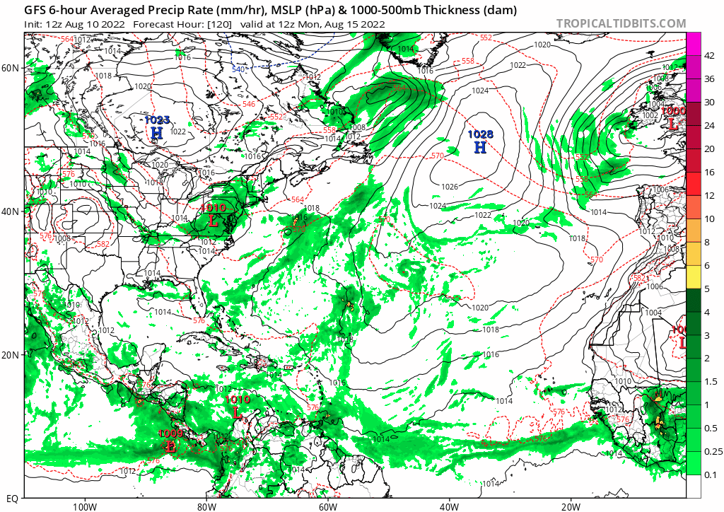
0 likes
-
DorkyMcDorkface

- Category 2

- Posts: 692
- Age: 26
- Joined: Mon Sep 30, 2019 1:32 pm
- Location: Mid-Atlantic
Re: 2022 Global Model Runs Discussion (Out thru day 16)
Teban54 wrote:12z GFS has a 999mb system in the subtropics next week:
https://i.postimg.cc/Hk4qx6Nb/gfs-mslp-pcpn-atl-fh120-366.gif
Appears to originate from 97L interestingly enough.

0 likes
Floyd 1999 | Isabel 2003 | Hanna 2008 | Irene 2011 | Sandy 2012 | Isaias 2020
Re: 2022 Global Model Runs Discussion (Out thru day 16)
NDG wrote:Will definitely have to wait until at least the end of August for anything to develop across the MDR. The same Euro which had it right with 97L struggling & fighting a dry air environment shows continuing dry air intrusions across the MDR from the mid latitudes.
https://i.imgur.com/Xs4yGKX.gif
Saying "Will definitely have to wait until at least the end of August for anything to develop across the MDR" seems premature to me. Saying possibly or even likely waiting til the end of August is one thing, but definitely no TC in the MDR at least til the end of August? It may happen but we are far from knowing that with certainty. When you say at least the end of August, do you mean the last few days like, say, August 26th-27th or so? If so, that obviously could happen, but saying it definitely will is another thing. Or do you just mean late August, like 8/20+? Even having none in the MDR by 8/20 is still far from a certainty. Keep in mind when I ask these questions that I'm not one who has been hyping this season nor do I want a hyper season.
5 likes
Personal Forecast Disclaimer:
The posts in this forum are NOT official forecasts and should not be used as such. They are just the opinion of the poster and may or may not be backed by sound meteorological data. They are NOT endorsed by any professional institution or storm2k.org. For official information, please refer to the NHC and NWS products.
The posts in this forum are NOT official forecasts and should not be used as such. They are just the opinion of the poster and may or may not be backed by sound meteorological data. They are NOT endorsed by any professional institution or storm2k.org. For official information, please refer to the NHC and NWS products.
-
skyline385
- Category 5
- Posts: 2444
- Age: 33
- Joined: Wed Aug 26, 2020 11:15 pm
- Location: Palm Beach County FL
Re: 2022 Global Model Runs Discussion (Out thru day 16)
DorkyMcDorkface wrote:Teban54 wrote:12z GFS has a 999mb system in the subtropics next week:
https://i.postimg.cc/Hk4qx6Nb/gfs-mslp-pcpn-atl-fh120-366.gif
Appears to originate from 97L interestingly enough.
Funny how the warm subtopics seem to be more favourable than the MDR right now
Sent from my iPhone using Tapatalk
1 likes

Re: 2022 Global Model Runs Discussion (Out thru day 16)
skyline385 wrote:DorkyMcDorkface wrote:Teban54 wrote:12z GFS has a 999mb system in the subtropics next week:
https://i.postimg.cc/Hk4qx6Nb/gfs-mslp-pcpn-atl-fh120-366.gif
Appears to originate from 97L interestingly enough.
https://i.ibb.co/rs9YmZz/ezgif-com-gif-maker-5.gif
Funny how the warm subtopics seem to be more favourable than the MDR right now
Sent from my iPhone using Tapatalk
Yeah it’s kind of been that way much of the last few years. We’ve seen plenty of storms intensifying at landfall and/or moving north of 27/28N.
0 likes
Re: 2022 Global Model Runs Discussion (Out thru day 16)
jaguars_22 wrote:ICON wants to spin up a quick storm for Texas Sunday!!!
That’s earlier than I thought if there was going to be anything near Texas, it would be middle of next week. Small chance that the MJO moving into Phase 2 this Friday or Saturday could help something spin up. There’s plenty of Gulf moisture to work with as a tropical wave interacts with a frontal boundary. It’s already rained 3x in New Orleans today so far, and we just went under a flash flood warning. I’m watching the dark grey clouds and rain move this way.
I still think it’s a small chance. And you never know with ICON as it sometimes beats the big boys in sniffing out development.
4 likes
Re: 2022 Global Model Runs Discussion (Out thru day 16)
Steve wrote:jaguars_22 wrote:ICON wants to spin up a quick storm for Texas Sunday!!!
That’s earlier than I thought if there was going to be anything near Texas, it would be middle of next week. Small chance that the MJO moving into Phase 2 this Friday or Saturday could help something spin up. There’s plenty of Gulf moisture to work with as a tropical wave interacts with a frontal boundary. It’s already rained 3x in New Orleans today so far, and we just went under a flash flood warning. I’m watching the dark grey clouds and rain move this way.
I still think it’s a small chance. And you never know with ICON as it sometimes beats the big boys in sniffing out development.
Looks like the NAM is sniffing something as well
2 likes
Harvey,Hanna,Beta,Texas Winter storm2021,Nicholas
Re: 2022 Global Model Runs Discussion (Out thru day 16)
The ICON is still a believer in a shortie for Sunday?!
0 likes
Harvey,Hanna,Beta,Texas Winter storm2021,Nicholas
Who is online
Users browsing this forum: afswo, cycloneye, CyclonicFury, KirbyDude25, Orlando_wx, zzzh and 96 guests