2022 Global Model Runs Discussion (Out thru day 16)
Moderator: S2k Moderators
Forum rules

The posts in this forum are NOT official forecasts and should not be used as such. They are just the opinion of the poster and may or may not be backed by sound meteorological data. They are NOT endorsed by any professional institution or STORM2K. For official information, please refer to products from the National Hurricane Center and National Weather Service.
-
Emmett_Brown

- Category 5

- Posts: 1343
- Joined: Wed Aug 24, 2005 9:10 pm
- Location: Sarasota FL
Re: 2022 Global Model Runs Discussion (Out thru day 16)
Just an observation about how we use models; remember just a week ago when most models killed off future Earl because of shear and dry air, and yet here we are. Earl is looking rather healthy, despite shear. Models are doing math, with a margin of error that gets exponentially larger with time. The one certainty with models is that they are all wrong, 100% of the time. But sometimes the amount of error is small enough to be useful. The only thing we can glean right now is that there may be storms.
16 likes
-
tolakram
- Admin

- Posts: 19165
- Age: 60
- Joined: Sun Aug 27, 2006 8:23 pm
- Location: Florence, KY (name is Mark)
Re: 2022 Global Model Runs Discussion (Out thru day 16)
Let's get back on topic please. Model runs.
5 likes
M a r k
- - - - -
Join us in chat: Storm2K Chatroom Invite. Android and IOS apps also available.
The posts in this forum are NOT official forecasts and should not be used as such. Posts are NOT endorsed by any professional institution or STORM2K.org. For official information and forecasts, please refer to NHC and NWS products.
-
Dean4Storms
- S2K Supporter

- Posts: 6355
- Age: 61
- Joined: Sun Aug 31, 2003 1:01 pm
- Location: Miramar Bch. FL
Re: 2022 Global Model Runs Discussion (Out thru day 16)
Nothing comes of it but the ECM does show some 850mb vorticity developing today into tomorrow over the central Gulf and a surface Low then moving northward underneath this cutoff ULL.
There’s always a chance something tries to spin up quickly, worth watching IMO.
There’s always a chance something tries to spin up quickly, worth watching IMO.
1 likes

Re: 2022 Global Model Runs Discussion (Out thru day 16)
Once again, the GFS is all alone in showing a dead tropics during peak season. The fact that 95L looks like a TD and the GFS has barely shown it existing would suggest the model’s dead MDR solutions are not very accurate, and with a positive CCKW coming into the basin in a few days, it’s possible the GFS is still having trouble correctly modeling a change in VP anomalies/changes in favorability.
2 likes
Irene '11 Sandy '12 Hermine '16 5/15/2018 Derecho Fay '20 Isaias '20 Elsa '21 Henri '21 Ida '21
I am only a meteorology enthusiast who knows a decent amount about tropical cyclones. Look to the professional mets, the NHC, or your local weather office for the best information.
I am only a meteorology enthusiast who knows a decent amount about tropical cyclones. Look to the professional mets, the NHC, or your local weather office for the best information.
-
skyline385

- Category 5
- Posts: 2444
- Age: 33
- Joined: Wed Aug 26, 2020 11:15 pm
- Location: Palm Beach County FL
Re: 2022 Global Model Runs Discussion (Out thru day 16)
aspen wrote:Once again, the GFS is all alone in showing a dead tropics during peak season. The fact that 95L looks like a TD and the GFS has barely shown it existing would suggest the model’s dead MDR solutions are not very accurate, and with a positive CCKW coming into the basin in a few days, it’s possible the GFS is still having trouble correctly modeling a change in VP anomalies/changes in favorability.
Always check vorticity plots, GFS was initialized correctly with 95L looking like a TD but it simply kills it off from unfavorable conditions. CIMSS also shows 95L battling 30-40 kts of shear with dry air to the west.
Lots of models were trigger happy about Earl too but it ended up developing only after 91L cleared the MDR, the conditions in the tropics just aren't that good right now. Remember, so far we have had a mid-latitude storm and a storm which managed to develop while recurving near the sub-tropics, there hasn't been any proof yet of conditions changing in the MDR.


Last edited by skyline385 on Thu Sep 08, 2022 7:58 am, edited 1 time in total.
2 likes

Re: 2022 Global Model Runs Discussion (Out thru day 16)
Yet another strong TUTT coming down north of the Caribbean for next week, don't look for any tropical activity in the central and eastern Caribbean 

1 likes
-
tolakram
- Admin
- Posts: 19165
- Age: 60
- Joined: Sun Aug 27, 2006 8:23 pm
- Location: Florence, KY (name is Mark)
Re: 2022 Global Model Runs Discussion (Out thru day 16)
I had to remove a bunch of posts whining about Florida not getting hit and the usual I don't like this season crap. If that's all you have to offer don't post, if you do expect a warning or suspension. We can't have every thread filling up with useless off topic posts.
We have a topic right here https://www.storm2k.org/phpbb2/viewtopi ... 1&t=122927 for posting about the slow start / or if the season is going to under perform. You're welcome to post in there if it's not related to a current model run.
We have a topic right here
11 likes
M a r k
- - - - -
Join us in chat: Storm2K Chatroom Invite. Android and IOS apps also available.
The posts in this forum are NOT official forecasts and should not be used as such. Posts are NOT endorsed by any professional institution or STORM2K.org. For official information and forecasts, please refer to NHC and NWS products.
- - - - -
Join us in chat: Storm2K Chatroom Invite. Android and IOS apps also available.
The posts in this forum are NOT official forecasts and should not be used as such. Posts are NOT endorsed by any professional institution or STORM2K.org. For official information and forecasts, please refer to NHC and NWS products.
-
skyline385
- Category 5
- Posts: 2444
- Age: 33
- Joined: Wed Aug 26, 2020 11:15 pm
- Location: Palm Beach County FL
Re: 2022 Global Model Runs Discussion (Out thru day 16)
Peak season btw

Sent from my iPhone using Tapatalk
Sent from my iPhone using Tapatalk
0 likes
-
ElectricStorm

- Category 5
- Posts: 4524
- Age: 23
- Joined: Tue Aug 13, 2019 11:23 pm
- Location: Skiatook, OK / Norman, OK
Re: 2022 Global Model Runs Discussion (Out thru day 16)
18z ICON has 2 MDR storms within 5 days, first one being the 0/30 wave with another one behind it near the Cabo Verde islands
0 likes
I am in no way a professional. Take what I say with a grain of salt as I could be totally wrong. Please refer to the NHC, NWS, or SPC for official information.
Boomer Sooner!
Boomer Sooner!
-
skyline385
- Category 5
- Posts: 2444
- Age: 33
- Joined: Wed Aug 26, 2020 11:15 pm
- Location: Palm Beach County FL
Re: 2022 Global Model Runs Discussion (Out thru day 16)
Looks like ICON 0Z backtracking now as well like the Euro with barely any development, the GFS got this bang on with all of the other models correcting themselves.

1 likes

Re: 2022 Global Model Runs Discussion (Out thru day 16)
Our lemon area seems to stay alive into the Bahamas per 00z GFS and CMC. Could be a sleeper.
1 likes
The following post is NOT an official forecast and should not be used as such. It is just the opinion of the poster and may or may not be backed by sound meteorological data. It is NOT endorsed by any professional institution including storm2k.org For Official Information please refer to the NHC and NWS products.
-
Emmett_Brown
- Category 5
- Posts: 1343
- Joined: Wed Aug 24, 2005 9:10 pm
- Location: Sarasota FL
Re: 2022 Global Model Runs Discussion (Out thru day 16)
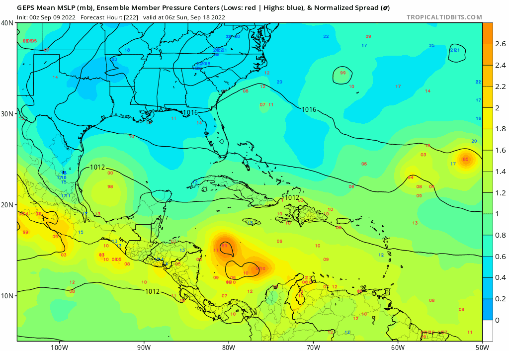
6Z GEFS (GFS Ensemble) showing some activity in the Western Caribbean after 220 hours. It might be the GFS' tendency toward overdoing gyres in this area, or it could be an indicator of a more favorable environment coming up in about 10 days. As always, anything after 120 hours is highly error prone, so use with caution.
0 likes
-
SFLcane

- S2K Supporter
- Posts: 9606
- Age: 46
- Joined: Sat Jun 05, 2010 1:44 pm
- Location: Lake Worth Florida
Re: 2022 Global Model Runs Discussion (Out thru day 16)
Emmett_Brown wrote:6Z GEFS (GFS Ensemble) showing some activity in the Western Caribbean after 220 hours. It might be the GFS' tendency toward overdoing gyres in this area, or it could be an indicator of a more favorable environment coming up in about 10 days. As always, anything after 120 hours is highly error prone, so use with caution.
Indeed!


0 likes
-
AutoPenalti
- Category 5
- Posts: 3949
- Age: 27
- Joined: Mon Aug 17, 2015 4:16 pm
- Location: Ft. Lauderdale, Florida
Re: 2022 Global Model Runs Discussion (Out thru day 16)
SFLcane wrote:Emmett_Brown wrote:6Z GEFS (GFS Ensemble) showing some activity in the Western Caribbean after 220 hours. It might be the GFS' tendency toward overdoing gyres in this area, or it could be an indicator of a more favorable environment coming up in about 10 days. As always, anything after 120 hours is highly error prone, so use with caution.
Indeed!
https://i.postimg.cc/W1BymsDL/gefs.gif
lol at that one member weaving around the shredder.
1 likes
The posts in this forum are NOT official forecasts and should not be used as such. They are just the opinion of the poster and may or may not be backed by sound meteorological data. They are NOT endorsed by any professional institution or STORM2K. For official information, please refer to products from the NHC and NWS.
Model Runs Cheat Sheet:
GFS (5:30 AM/PM, 11:30 AM/PM)
HWRF, GFDL, UKMET, NAVGEM (6:30-8:00 AM/PM, 12:30-2:00 AM/PM)
ECMWF (1:45 AM/PM)
TCVN is a weighted averaged
-
crownweather

- S2K Supporter
- Posts: 575
- Age: 49
- Joined: Sat Aug 12, 2006 9:21 am
- Location: Sturbridge, Massachusetts
- Contact:
Re: 2022 Global Model Runs Discussion (Out thru day 16)
And the GEPS also shows some signs of possible tropical mischief towards the end of the month. EPS, on the other, is quiet.
0 likes
Rob Lightbown
Crown Weather Services
https://crownweather.com
Crown Weather Services
https://crownweather.com
-
cheezyWXguy

- Category 5
- Posts: 5528
- Joined: Mon Feb 13, 2006 12:29 am
- Location: Dallas, TX
Re: 2022 Global Model Runs Discussion (Out thru day 16)
Not a moment too soon, guess what’s now showing up on the 12z gfs…
0 likes


-
skyline385
- Category 5
- Posts: 2444
- Age: 33
- Joined: Wed Aug 26, 2020 11:15 pm
- Location: Palm Beach County FL
Re: 2022 Global Model Runs Discussion (Out thru day 16)
This face on today's Euro perfectly summaries the global models for the 2022 season 

5 likes
Re: 2022 Global Model Runs Discussion (Out thru day 16)
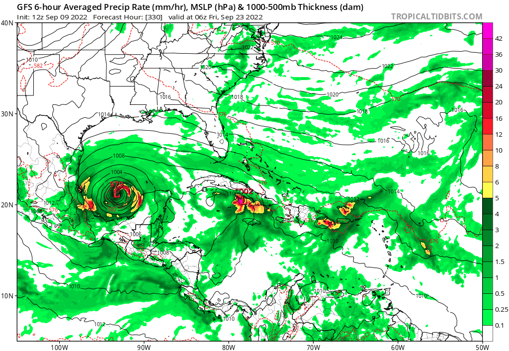
18z GFS showing this in the eastern Gulf in about 12-14 days. Forms from the phantom storm generator off Columbia/South America. A few earlier runs hinted at something there too, but this is the first time it has shown a hurricane.

0 likes
Who is online
Users browsing this forum: No registered users and 35 guests