GFS bringing back the good old weenie runs... switch is just about to flip
2022 Global Model Runs Discussion (Out thru day 16)
Moderator: S2k Moderators
Forum rules

The posts in this forum are NOT official forecasts and should not be used as such. They are just the opinion of the poster and may or may not be backed by sound meteorological data. They are NOT endorsed by any professional institution or STORM2K. For official information, please refer to products from the National Hurricane Center and National Weather Service.
-
NotSparta

- Professional-Met

- Posts: 1649
- Age: 22
- Joined: Fri Aug 18, 2017 8:24 am
- Location: Naples, FL
- Contact:
Re: 2022 Global Model Runs Discussion (Out thru day 16)
GFS bringing back the good old weenie runs... switch is just about to flip
9 likes
This post was probably an opinion of mine, and in no way is official. Please refer to http://www.hurricanes.gov for official tropical analysis and advisories.
My website, with lots of tropical wx graphics, including satellite and recon: http://cyclonicwx.com
My website, with lots of tropical wx graphics, including satellite and recon: http://cyclonicwx.com
-
Kingarabian

- S2K Supporter

- Posts: 15437
- Joined: Sat Aug 08, 2009 3:06 am
- Location: Honolulu, Hawaii
Re: 2022 Global Model Runs Discussion (Out thru day 16)
00z GFS basically Harveys SLA. Massive flooding if that solution materializes.
1 likes
RIP Kobe Bryant
-
AxaltaRacing24
- Category 5

- Posts: 1709
- Age: 23
- Joined: Wed Jul 27, 2016 11:14 am
- Location: Jupiter, FL
Re: 2022 Global Model Runs Discussion (Out thru day 16)
NotSparta wrote:
GFS bringing back the good old weenie runs... switch is just about to flip
and there was lots of 2013 talk as recently as 48 hours ago
6 likes
Re: 2022 Global Model Runs Discussion (Out thru day 16)
AxaltaRacing24 wrote:NotSparta wrote:
GFS bringing back the good old weenie runs... switch is just about to flip
and there was lots of 2013 talk as recently as 48 hours ago
The 1998 hurricane season had only one tropical storm up until this date then it turned into one of the most disasterous hyperactive seasons on record at the time. It is never over until it's over.
4 likes
-
skyline385

- Category 5
- Posts: 2444
- Age: 33
- Joined: Wed Aug 26, 2020 11:15 pm
- Location: Palm Beach County FL
Re: 2022 Global Model Runs Discussion (Out thru day 16)
lol at the size of the chonker the GFS manages to form with two other hurricanes besides it.

Sent from my iPhone using Tapatalk
Sent from my iPhone using Tapatalk
3 likes
-
skyline385
- Category 5
- Posts: 2444
- Age: 33
- Joined: Wed Aug 26, 2020 11:15 pm
- Location: Palm Beach County FL
2022 Global Model Runs Discussion (Out thru day 16)
Kingarabian wrote::uarrow:
00z GFS basically Harveys SLA. Massive flooding if that solution materializes.
Interestingly enough, Texas is getting its own Harvey from what looks like the BoC system.

Sent from my iPhone using Tapatalk
0 likes
-
jlauderdal
- S2K Supporter
- Posts: 6772
- Joined: Wed May 19, 2004 5:46 am
- Location: NE Fort Lauderdale
- Contact:
Re: 2022 Global Model Runs Discussion (Out thru day 16)
GFS won't be denied an active season, whether it's close to reality remains to be seen, but we can always count on the GFS to provide plenty of ammo for this board. Happy Hurricane Hunting
0 likes

Re: 2022 Global Model Runs Discussion (Out thru day 16)
06z GFS operational with 3 TCs before September starts and this isn't even counting the possible short-term system near Central America which is looking pretty good on radar right now.
1) The main MDR wave we're seeing in the models, starts forming on August 19. Slowly meanders across the MDR and starts rapidly intensifying around August 26. Peaks as a 952 mbar MH and directly hits Bermuda.
2) WCar/GOM system, forms August 23. Moves between Yucatan and Cuba and then rapidly intensifies into a ~cat 2 hurricane (971 mbar) before an Alabama landfall on August 28.
3) MDR wave behind #1. Starts forming on August 25. Remains a moderate TS for most of its MDR run, further intensifies on August 31. Still intensifying and at 976 mbar at the end of the run.
4) Small system in the northern Atlantic which randomly pops up on September 1. Not sure if it's fully tropical, but if so it would technically count as a NS.
1 likes
-
SFLcane

- S2K Supporter
- Posts: 9607
- Age: 46
- Joined: Sat Jun 05, 2010 1:44 pm
- Location: Lake Worth Florida
Re: 2022 Global Model Runs Discussion (Out thru day 16)

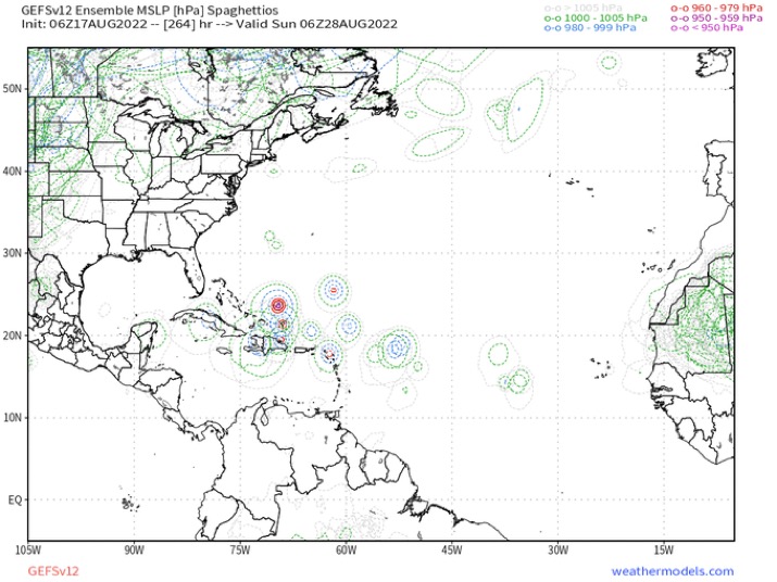
image removed
Last edited by tolakram on Wed Aug 17, 2022 7:44 am, edited 1 time in total.
Reason: removed personal use only image
Reason: removed personal use only image
0 likes

Re: 2022 Global Model Runs Discussion (Out thru day 16)
We will see how GFS does. ICON got 98L. As all the posts above show, GFS shows a burst of 3 or 4 systems in the next 2 weeks. I’m assuming it’s MJO related. 4 would take us to the G storm a weak or so before the peak.
1 likes
-
Blown Away

- S2K Supporter
- Posts: 9863
- Joined: Wed May 26, 2004 6:17 am
Re: 2022 Global Model Runs Discussion (Out thru day 16)
Image removed
06z GEFS... Very active
06z GEFS... Very active
Last edited by tolakram on Wed Aug 17, 2022 7:41 am, edited 1 time in total.
Reason: removed no share image
Reason: removed no share image
0 likes
Hurricane Eye Experience: David 79, Irene 99, Frances 04, Jeanne 04, Wilma 05...
Hurricane Brush Experience: Andrew 92, Erin 95, Floyd 99, Matthew 16, Irma 17, Ian 22, Nicole 22…
Hurricane Brush Experience: Andrew 92, Erin 95, Floyd 99, Matthew 16, Irma 17, Ian 22, Nicole 22…
-
tolakram
- Admin

- Posts: 19165
- Age: 60
- Joined: Sun Aug 27, 2006 8:23 pm
- Location: Florence, KY (name is Mark)
Re: 2022 Global Model Runs Discussion (Out thru day 16)
Please do not post images that are marked as personal use only. Weathermodels is very explicit about GIFS, a little more vague about non animated images. If the image has PERSONAL USE ONLY on the image then do not post it here. Thanks.
1 likes
M a r k
- - - - -
Join us in chat: Storm2K Chatroom Invite. Android and IOS apps also available.
The posts in this forum are NOT official forecasts and should not be used as such. Posts are NOT endorsed by any professional institution or STORM2K.org. For official information and forecasts, please refer to NHC and NWS products.
-
Iceresistance

- Category 5
- Posts: 8915
- Age: 20
- Joined: Sat Oct 10, 2020 9:45 am
- Location: Tecumseh, OK/Norman, OK
Re: 2022 Global Model Runs Discussion (Out thru day 16)
6z GEFS has a much stronger member consistency compared to the past several runs.

https://s4.gifyu.com/images/gfs-ememb_lowlocs_atl_fh48-384.gif
https://s4.gifyu.com/images/gfs-ememb_lowlocs_atl_fh48-384.gif
0 likes
Bill 2015 & Beta 2020
Winter 2020-2021
All observations are in Tecumseh, OK unless otherwise noted.
Winter posts are focused mainly for Oklahoma & Texas.
Take any of my forecasts with a grain of salt, refer to the NWS, SPC, and NHC for official information
Never say Never with weather! Because ANYTHING is possible!
Winter 2020-2021
All observations are in Tecumseh, OK unless otherwise noted.
Winter posts are focused mainly for Oklahoma & Texas.
Take any of my forecasts with a grain of salt, refer to the NWS, SPC, and NHC for official information
Never say Never with weather! Because ANYTHING is possible!
-
wxman57

- Moderator-Pro Met

- Posts: 22482
- Age: 66
- Joined: Sat Jun 21, 2003 8:06 pm
- Location: Houston, TX (southwest)
Re: 2022 Global Model Runs Discussion (Out thru day 16)
skyline385 wrote:Interestingly enough, Texas is getting its own Harvey from what looks like the BoC system.
https://uploads.tapatalk-cdn.com/20220817/824a81b6a5e05575fcfa843a29c029c0.jpg
That rain appears to be front-related. All rain from the disturbance goes into Mexico.
1 likes
-
SFLcane
- S2K Supporter
- Posts: 9607
- Age: 46
- Joined: Sat Jun 05, 2010 1:44 pm
- Location: Lake Worth Florida
Re: 2022 Global Model Runs Discussion (Out thru day 16)
Wxman57 any thoughts on the GEFS and wave of Africa?
0 likes
-
wxman57
- Moderator-Pro Met
- Posts: 22482
- Age: 66
- Joined: Sat Jun 21, 2003 8:06 pm
- Location: Houston, TX (southwest)
Re: 2022 Global Model Runs Discussion (Out thru day 16)
I know that some of you are quite excited about hurricane development, but I would urge you to use caution when believing the long-range GFS. It has a habit of predicting many modelcanes in the long range. That said, the disturbance in the NW Caribbean looks more impressive, to me, than the models are indicating. GFS, EC, and ICON have it over Nicaragua at 12Z today, but it appears to be farther north over the NW Caribbean. Big difference as far as development potential.
4 likes
-
toad strangler

- S2K Supporter
- Posts: 4162
- Joined: Sun Jul 28, 2013 3:09 pm
- Location: Earth
- Contact:
Re: 2022 Global Model Runs Discussion (Out thru day 16)
wxman57 wrote:I know that some of you are quite excited about hurricane development, but I would urge you to use caution when believing the long-range GFS. It has a habit of predicting many modelcanes in the long range.
True, but NOAA has had the MDR highlighted in it's global tropical hazard product for a while now. Very good chance a storm's a brewing. The where is it going to go is the huge question and 300 hours out is Alice In Wonderland range for sure.
3 likes
-
wxman57
- Moderator-Pro Met
- Posts: 22482
- Age: 66
- Joined: Sat Jun 21, 2003 8:06 pm
- Location: Houston, TX (southwest)
Re: 2022 Global Model Runs Discussion (Out thru day 16)
toad strangler wrote:wxman57 wrote:I know that some of you are quite excited about hurricane development, but I would urge you to use caution when believing the long-range GFS. It has a habit of predicting many modelcanes in the long range.
True, but NOAA has had the MDR highlighted in it's global tropical hazard product for a while now. Very good chance a storm's a brewing. The where is it going to go is the huge question and 300 hours out is Alice In Wonderland range for sure.
What??? We should keep an eye on the MDR in late August? That's insane!
I notice that the GFS & Euro are predicting strong northerly wind shear across the NW Gulf as the disturbance approaches on Saturday. That should keep it south of TX.
2 likes
-
skyline385
- Category 5
- Posts: 2444
- Age: 33
- Joined: Wed Aug 26, 2020 11:15 pm
- Location: Palm Beach County FL
2022 Global Model Runs Discussion (Out thru day 16)
wxman57 wrote:skyline385 wrote:Interestingly enough, Texas is getting its own Harvey from what looks like the BoC system.
https://uploads.tapatalk-cdn.com/20220817/824a81b6a5e05575fcfa843a29c029c0.jpg
That rain appears to be front-related. All rain from the disturbance goes into Mexico.
It is front related but on the vorticity plot there seems to be some sort of Fujiwhara interaction with the BoC system.

Sent from my iPhone using Tapatalk
0 likes
-
skyline385
- Category 5
- Posts: 2444
- Age: 33
- Joined: Wed Aug 26, 2020 11:15 pm
- Location: Palm Beach County FL
Re: 2022 Global Model Runs Discussion (Out thru day 16)
Wow, GEFS took my FL shield joke personally

Sent from my iPhone using Tapatalk
Sent from my iPhone using Tapatalk
9 likes
Who is online
Users browsing this forum: ColbyP06, Hypercane_Kyle and 166 guests