2022 Global Model Runs Discussion (Out thru day 16)
Moderator: S2k Moderators
Forum rules

The posts in this forum are NOT official forecasts and should not be used as such. They are just the opinion of the poster and may or may not be backed by sound meteorological data. They are NOT endorsed by any professional institution or STORM2K. For official information, please refer to products from the National Hurricane Center and National Weather Service.
-
crownweather

- S2K Supporter

- Posts: 576
- Age: 49
- Joined: Sat Aug 12, 2006 9:21 am
- Location: Sturbridge, Massachusetts
- Contact:
Re: 2022 Global Model Runs Discussion (Out thru day 16)
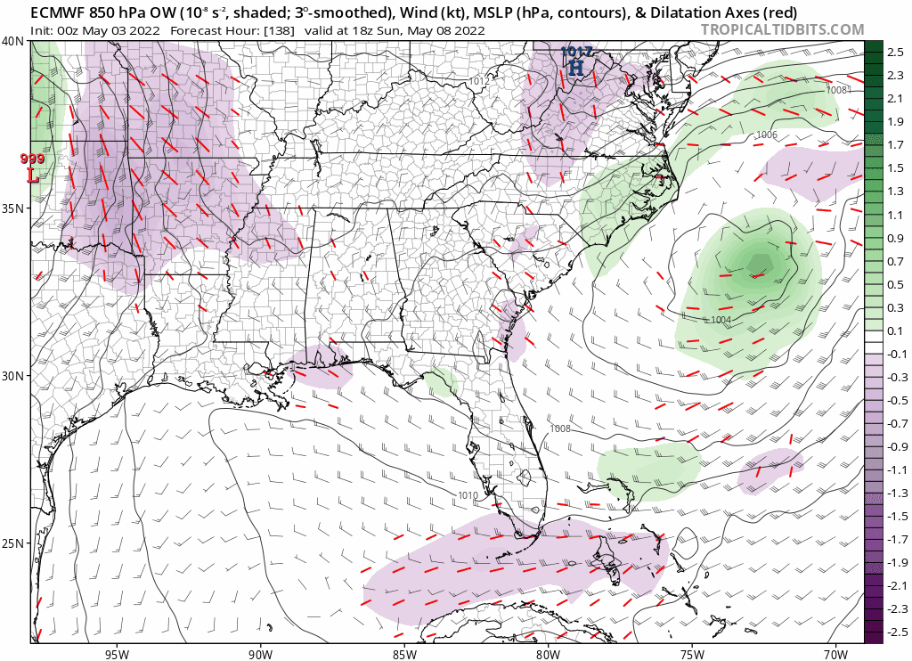
Starting to think the area just off of the SE Coast and Mid-Atlantic coast may be a spot to watch for sub-tropical development next week. Non-tropical low forecast by all models to sit and spin off East Coast by early next week. In fact, Euro and Canadian model forecasts this low to sink as far south as the northern Bahamas by Wednesday and Thursday of next week. Could be a player where we see Alex named before 1 June.
8 likes
Rob Lightbown
Crown Weather Services
https://crownweather.com
Crown Weather Services
https://crownweather.com
-
AJC3

- Admin

- Posts: 3873
- Age: 60
- Joined: Tue Aug 31, 2004 7:04 pm
- Location: West Melbourne, Florida
- Contact:
Re: 2022 Global Model Runs Discussion (Out thru day 16)
00Z op-ECM showed much more retrogression of the stacked low SW-ward offshore the SE seaboard and across FL, compared to the op-GFS. Then the 06Z GFS came along and trended strongly toward the ECM, bringing the low into Florida in about 9 days. The solutions look quite similar at the moment. Regardless of whether the low remains an XTC or turns into some sort of hybrid/STC, this looks like it could have a significant impact along the mid Atlantic and SE US coast. Pressure gradient along the western semicircle of the low looks to bring (near) gale conditions (strong winds, high seas and surf, beach erosion, coastal flooding, etc.) to the coast, and possibly a full blown gale over the adjacent Atlantic. Stay tuned...
7 likes

-
tropicwatch

- Category 5

- Posts: 3205
- Age: 60
- Joined: Sat Jun 02, 2007 10:01 am
- Location: Panama City Florida
- Contact:
Re: 2022 Global Model Runs Discussion (Out thru day 16)
That would be interesting 
0 likes
Tropicwatch
Agnes 72', Eloise 75, Elena 85', Kate 85', Charley 86', Florence 88', Beryl 94', Dean 95', Erin 95', Opal 95', Earl 98', Georges 98', Ivan 2004', Arlene 2005', Dennis 2005', Ida 2009' Debby 2012' Irma 2017' Michael 2018'
Agnes 72', Eloise 75, Elena 85', Kate 85', Charley 86', Florence 88', Beryl 94', Dean 95', Erin 95', Opal 95', Earl 98', Georges 98', Ivan 2004', Arlene 2005', Dennis 2005', Ida 2009' Debby 2012' Irma 2017' Michael 2018'
-
CyclonicFury

- Category 5
- Posts: 1975
- Age: 25
- Joined: Sun Jul 02, 2017 12:32 pm
- Location: NC
- Contact:
Re: 2022 Global Model Runs Discussion (Out thru day 16)
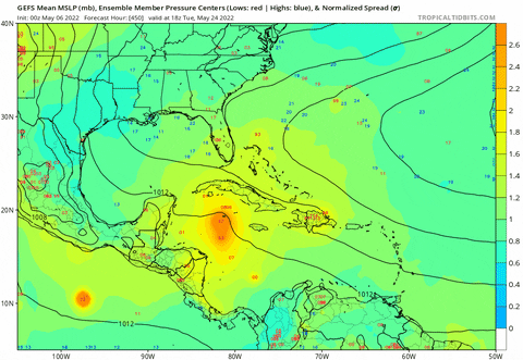
In addition to the possible system off the US east coast, a signal is increasing on the GEFS and EPS for possible EPAC development in about 12-14 days. It is not uncommon for -ENSO EPAC seasons to start relatively early.


6 likes
NCSU B.S. in Meteorology Class of 2021. Tropical weather blogger at http://www.cyclonicfury.com. My forecasts and thoughts are NOT official, for official forecasts please consult the National Hurricane Center.
-
weeniepatrol

- Category 3

- Posts: 857
- Joined: Sat Aug 22, 2020 5:30 pm
- Location: WA State
Re: 2022 Global Model Runs Discussion (Out thru day 16)
Could be legit…
Nvm saw the timeframe
0 likes
-
Category5Kaiju

- Category 5
- Posts: 3357
- Age: 22
- Joined: Thu Dec 24, 2020 12:45 pm
- Location: Seattle
Re: 2022 Global Model Runs Discussion (Out thru day 16)

CMC likes that potential cutoff SE CONUS system by late next week
0 likes
Unless explicitly stated, all information covered in my posts is based on my opinions and observations. Please refer to a professional meteorologist or an accredited weather research agency otherwise, especially if serious decisions must be made in the event of a potentially life-threatening tropical storm or hurricane.
-
AlphaToOmega
- Category 5
- Posts: 1448
- Joined: Sat Jun 26, 2021 10:51 am
- Location: Somewhere in Massachusetts
Re: 2022 Global Model Runs Discussion (Out thru day 16)
Category5Kaiju wrote:https://i.imgur.com/OwHpyQf.png
CMC likes that potential cutoff SE CONUS system by late next week
It seems as if the models seem to be backing off of this system.
0 likes
-
tropicwatch
- Category 5
- Posts: 3205
- Age: 60
- Joined: Sat Jun 02, 2007 10:01 am
- Location: Panama City Florida
- Contact:
Re: 2022 Global Model Runs Discussion (Out thru day 16)
Both GFS and Euro have low pressure off the U.S. southeast coast around the 12th of May. Not as deep as previous runs.
0 likes
Tropicwatch
Agnes 72', Eloise 75, Elena 85', Kate 85', Charley 86', Florence 88', Beryl 94', Dean 95', Erin 95', Opal 95', Earl 98', Georges 98', Ivan 2004', Arlene 2005', Dennis 2005', Ida 2009' Debby 2012' Irma 2017' Michael 2018'
Agnes 72', Eloise 75, Elena 85', Kate 85', Charley 86', Florence 88', Beryl 94', Dean 95', Erin 95', Opal 95', Earl 98', Georges 98', Ivan 2004', Arlene 2005', Dennis 2005', Ida 2009' Debby 2012' Irma 2017' Michael 2018'
-
DorkyMcDorkface

- Category 2

- Posts: 698
- Age: 26
- Joined: Mon Sep 30, 2019 1:32 pm
- Location: Mid-Atlantic
Re: 2022 Global Model Runs Discussion (Out thru day 16)
MJO should arrive in the Western Atlantic/EPAC by mid-late month, wondering if we could see a CAG setup by then.

1 likes
Floyd 1999 | Isabel 2003 | Hanna 2008 | Irene 2011 | Sandy 2012 | Isaias 2020
-
cycloneye

- Admin
- Posts: 139083
- Age: 67
- Joined: Thu Oct 10, 2002 10:54 am
- Location: San Juan, Puerto Rico
Re: 2022 Global Model Runs Discussion (Out thru day 16)
DorkyMcDorkface wrote:MJO should arrive in the Western Atlantic/EPAC by mid-late month, wondering if we could see a CAG setup by then.
https://i.ibb.co/j8GTLZH/eps-chi200-anomaly-globe-2022050500-MEAN-360.png
Or dual areas in EPAC and West or SW Caribbean.
0 likes
Visit the Caribbean-Central America Weather Thread where you can find at first post web cams,radars
and observations from Caribbean basin members Click Here
and observations from Caribbean basin members Click Here
-
DorkyMcDorkface
- Category 2
- Posts: 698
- Age: 26
- Joined: Mon Sep 30, 2019 1:32 pm
- Location: Mid-Atlantic
Re: 2022 Global Model Runs Discussion (Out thru day 16)
AlphaToOmega wrote:Category5Kaiju wrote:https://i.imgur.com/OwHpyQf.png
CMC likes that potential cutoff SE CONUS system by late next week
It seems as if the models seem to be backing off of this system.
Looks like it came back to an extent on the latest GFS run:

0 likes
Floyd 1999 | Isabel 2003 | Hanna 2008 | Irene 2011 | Sandy 2012 | Isaias 2020
-
Category5Kaiju
- Category 5
- Posts: 3357
- Age: 22
- Joined: Thu Dec 24, 2020 12:45 pm
- Location: Seattle
Re: 2022 Global Model Runs Discussion (Out thru day 16)
DorkyMcDorkface wrote:AlphaToOmega wrote:Category5Kaiju wrote:https://i.imgur.com/OwHpyQf.png
CMC likes that potential cutoff SE CONUS system by late next week
It seems as if the models seem to be backing off of this system.
Looks like it came back to an extent on the latest GFS run:
https://cdn.discordapp.com/attachments/733552978572869632/971906677827842088/gfs_z850_vort_watl_fh150-210_1.gif
Quite reminiscent of Danny from last year or Bertha 2020
0 likes
Unless explicitly stated, all information covered in my posts is based on my opinions and observations. Please refer to a professional meteorologist or an accredited weather research agency otherwise, especially if serious decisions must be made in the event of a potentially life-threatening tropical storm or hurricane.
-
cycloneye
- Admin
- Posts: 139083
- Age: 67
- Joined: Thu Oct 10, 2002 10:54 am
- Location: San Juan, Puerto Rico
Re: 2022 Global Model Runs Discussion (Out thru day 16)
IMO, has a good chance to be STS Alex. Gulfstream does magic things many times.

4 likes
Visit the Caribbean-Central America Weather Thread where you can find at first post web cams,radars
and observations from Caribbean basin members Click Here
and observations from Caribbean basin members Click Here
-
jaxfladude
- Category 5
- Posts: 1246
- Joined: Wed Aug 24, 2005 9:36 pm
- Location: Jacksonville, Fla
Re: RE: Re: 2022 Global Model Runs Discussion (Out thru day 16)
Oh yes the almost yearly Northeast Florida to the border of Georgia/South Carolina model tracker of a tropical system.cycloneye wrote:IMO, has a good chance to be STS Alex. Gulfstream does magic things many times.

0 likes
Stay safe y'all
-
Astromanía
- Category 2
- Posts: 737
- Age: 25
- Joined: Sat Aug 25, 2018 10:34 pm
- Location: Monterrey, N.L, México
Re: 2022 Global Model Runs Discussion (Out thru day 16)
I really need this season to start as soon as posible, half of Mexico is in a severe drought, especially north Mexico. Seriously you don't want to know what feels not to have water to consume, tropical cyclones are considered as natural disasters but they are actually really benefical in many ways
7 likes
-
DorkyMcDorkface
- Category 2
- Posts: 698
- Age: 26
- Joined: Mon Sep 30, 2019 1:32 pm
- Location: Mid-Atlantic
Re: 2022 Global Model Runs Discussion (Out thru day 16)
cycloneye wrote:IMO, has a good chance to be STS Alex. Gulfstream does magic things many times.
https://i.imgur.com/xElwDis.gif
https://twitter.com/andyhazelton/status/1522644245315833859
1 likes
Floyd 1999 | Isabel 2003 | Hanna 2008 | Irene 2011 | Sandy 2012 | Isaias 2020
-
Category5Kaiju
- Category 5
- Posts: 3357
- Age: 22
- Joined: Thu Dec 24, 2020 12:45 pm
- Location: Seattle
Re: 2022 Global Model Runs Discussion (Out thru day 16)
18z GFS still really likes the Eastern Seaboard system next week; makes landfall in Georgia as what looks to be a weak TS
0 likes
Unless explicitly stated, all information covered in my posts is based on my opinions and observations. Please refer to a professional meteorologist or an accredited weather research agency otherwise, especially if serious decisions must be made in the event of a potentially life-threatening tropical storm or hurricane.

Re: 2022 Global Model Runs Discussion (Out thru day 16)
What I am excited about the cold core low the GFS shows or showed briefly getting subtropical characteristics is that it will cool us down here in central FL with highs only in the low to mid 80s during the upcoming week after highs in the mid 90s the last few days
3 likes
-
skyline385

- Category 5
- Posts: 2444
- Age: 33
- Joined: Wed Aug 26, 2020 11:15 pm
- Location: Palm Beach County FL
Re: 2022 Global Model Runs Discussion (Out thru day 16)
DorkyMcDorkface wrote:MJO should arrive in the Western Atlantic/EPAC by mid-late month, wondering if we could see a CAG setup by then.
https://i.ibb.co/j8GTLZH/eps-chi200-anomaly-globe-2022050500-MEAN-360.png
The GEFS has been hinting at a CAG setup in the long runs but it could just end up being a typical GFS phantom.
1 likes
Who is online
Users browsing this forum: gib, lilbump3000, zzzh and 243 guests