Tropical Weather Outlook
NWS National Hurricane Center Miami FL
800 PM EDT Sun May 29 2022
For the North Atlantic...Caribbean Sea and the Gulf of Mexico:
Near the Yucatan Peninsula:
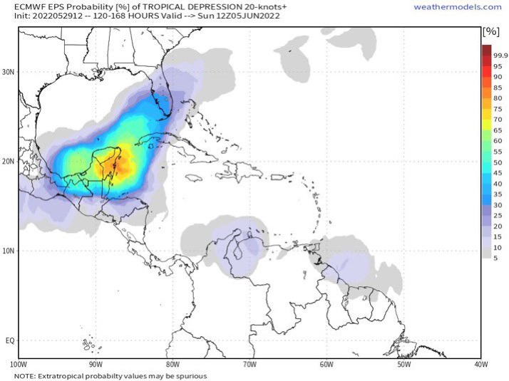
A large and complex area of low pressure is expected to develop
across Central America, the Yucatan Peninsula, and the southwest
Gulf of Mexico in a few days, partially related to the remnants of
Hurricane Agatha from the eastern Pacific. Some gradual development
is possible within this system in the far southwest Gulf of Mexico
by mid-week or in the northwest Caribbean by the latter part of this
week as the larger low complex drifts eastward or northeastward.
Regardless of development, locally heavy rains will be possible
across southern Mexico, the Yucatan Peninsula, Guatemala, and Belize
through the week.
* Formation chance through 48 hours...low...near 0 percent.
* Formation chance through 5 days...low...30 percent.
$$
Forecaster Papin
NWS National Hurricane Center Miami FL
800 PM EDT Sun May 29 2022
For the North Atlantic...Caribbean Sea and the Gulf of Mexico:
Near the Yucatan Peninsula:
A large and complex area of low pressure is expected to develop
across Central America, the Yucatan Peninsula, and the southwest
Gulf of Mexico in a few days, partially related to the remnants of
Hurricane Agatha from the eastern Pacific. Some gradual development
is possible within this system in the far southwest Gulf of Mexico
by mid-week or in the northwest Caribbean by the latter part of this
week as the larger low complex drifts eastward or northeastward.
Regardless of development, locally heavy rains will be possible
across southern Mexico, the Yucatan Peninsula, Guatemala, and Belize
through the week.
* Formation chance through 48 hours...low...near 0 percent.
* Formation chance through 5 days...low...30 percent.
$$
Forecaster Papin