Area of interest in SW Caribbean (Is Invest 93L)

This is the general tropical discussion area. Anyone can take their shot at predicting a storms path.

Moderator: S2k Moderators

Forum rules

The posts in this forum are NOT official forecasts and should not be used as such. They are just the opinion of the poster and may or may not be backed by sound meteorological data. They are NOT endorsed by any professional institution or STORM2K. For official information, please refer to products from the National Hurricane Center and National Weather Service.

Help Support Storm2K
Message
Author
User avatar
cycloneye
Admin
Admin
Posts: 139026
Age: 67
Joined: Thu Oct 10, 2002 10:54 am
Location: San Juan, Puerto Rico

Area of interest in SW Caribbean (Is Invest 93L)

#1 Postby cycloneye » Sun Jun 12, 2022 12:31 pm

Tropical Weather Outlook
NWS National Hurricane Center Miami FL
200 PM EDT Sun Jun 12 2022

For the North Atlantic...Caribbean Sea and the Gulf of Mexico:

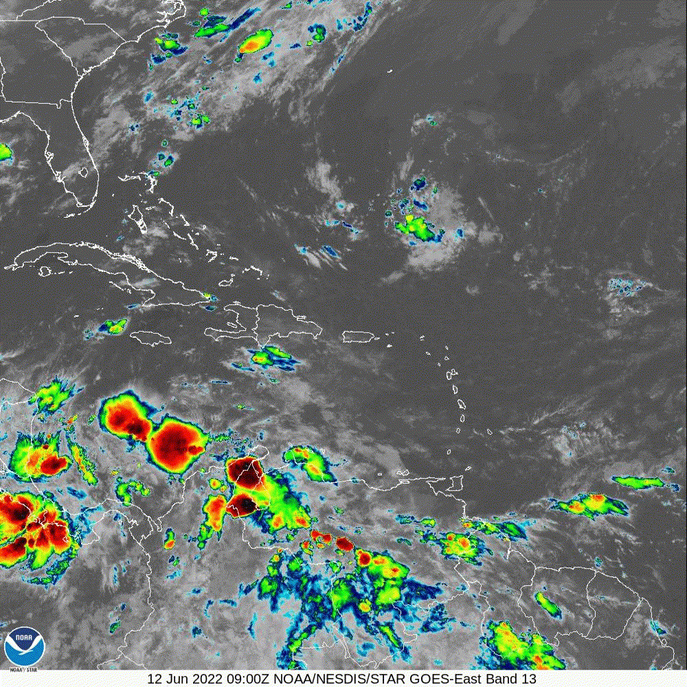
Southwestern Caribbean Sea:
An area of low pressure is expected to develop by the middle part
of this week over the southwestern Caribbean Sea. Some slow
development of this system is possible while it drifts generally
northwestward off the coasts of Nicaragua and Honduras.
* Formation chance through 48 hours...near 0 percent.
* Formation chance through 5 days...20 percent.

$$
Forecaster Roberts


Image
2 likes   
Visit the Caribbean-Central America Weather Thread where you can find at first post web cams,radars
and observations from Caribbean basin members Click Here

User avatar
Category5Kaiju
Category 5
Category 5
Posts: 3351
Age: 22
Joined: Thu Dec 24, 2020 12:45 pm
Location: Seattle

Re: Area of interest in SW Caribbean

#2 Postby Category5Kaiju » Sun Jun 12, 2022 12:40 pm

This is going to be an interesting thread, I can tell :D
2 likes   
Unless explicitly stated, all information covered in my posts is based on my opinions and observations. Please refer to a professional meteorologist or an accredited weather research agency otherwise, especially if serious decisions must be made in the event of a potentially life-threatening tropical storm or hurricane.

User avatar
captainbarbossa19
Category 5
Category 5
Posts: 1039
Joined: Wed Aug 21, 2019 11:09 pm
Location: Starkville, MS

Re: Area of interest in SW Caribbean

#3 Postby captainbarbossa19 » Sun Jun 12, 2022 12:54 pm

Nothing may come of this, but I also will not be surprised if we get Bonnie before it's over.
0 likes   

User avatar
cycloneye
Admin
Admin
Posts: 139026
Age: 67
Joined: Thu Oct 10, 2002 10:54 am
Location: San Juan, Puerto Rico

Re: Area of interest in SW Caribbean

#4 Postby cycloneye » Sun Jun 12, 2022 1:03 pm

captainbarbossa19 wrote:Nothing may come of this, but I also will not be surprised if we get Bonnie before it's over.


Before what is over?
0 likes   
Visit the Caribbean-Central America Weather Thread where you can find at first post web cams,radars
and observations from Caribbean basin members Click Here

Sciencerocks
Category 5
Category 5
Posts: 7282
Age: 38
Joined: Thu Jul 06, 2017 1:51 am

Re: Area of interest in SW Caribbean

#5 Postby Sciencerocks » Sun Jun 12, 2022 1:08 pm

Image
1 likes   

zzh
Category 1
Category 1
Posts: 375
Joined: Fri Aug 27, 2021 2:18 pm

Re: Area of interest in SW Caribbean

#6 Postby zzh » Sun Jun 12, 2022 1:16 pm

Image
1 likes   

User avatar
SFLcane
S2K Supporter
S2K Supporter
Posts: 9606
Age: 46
Joined: Sat Jun 05, 2010 1:44 pm
Location: Lake Worth Florida

Re: Area of interest in SW Caribbean

#7 Postby SFLcane » Sun Jun 12, 2022 1:18 pm

But But but thought it was a model cane. Hate to say it but the gfs has been on the money a good chunk of the time so far this season.
4 likes   

User avatar
Kingarabian
S2K Supporter
S2K Supporter
Posts: 15432
Joined: Sat Aug 08, 2009 3:06 am
Location: Honolulu, Hawaii

Re: Area of interest in SW Caribbean

#8 Postby Kingarabian » Sun Jun 12, 2022 1:24 pm

SFLcane wrote:But But but thought it was a model cane. Hate to say it but the gfs has been on the money a good chunk of the time so far this season.

Let's not conveniently forget that this model makes every storm a landfalling major hurricane. The model can sniff out storms earlier than others, no one is denying that, the issue is its final solutions.
9 likes   
RIP Kobe Bryant

User avatar
skyline385
Category 5
Category 5
Posts: 2444
Age: 33
Joined: Wed Aug 26, 2020 11:15 pm
Location: Palm Beach County FL

Re: Area of interest in SW Caribbean

#9 Postby skyline385 » Sun Jun 12, 2022 1:32 pm

Ridge still strong on Euro but it does seem to be slightly weaker compared to previous runs

Image
Last edited by skyline385 on Sun Jun 12, 2022 1:52 pm, edited 1 time in total.
0 likes   

User avatar
skyline385
Category 5
Category 5
Posts: 2444
Age: 33
Joined: Wed Aug 26, 2020 11:15 pm
Location: Palm Beach County FL

Re: Area of interest in SW Caribbean

#10 Postby skyline385 » Sun Jun 12, 2022 1:52 pm

Kingarabian wrote:
SFLcane wrote:But But but thought it was a model cane. Hate to say it but the gfs has been on the money a good chunk of the time so far this season.

Let's not conveniently forget that this model makes every storm a landfalling major hurricane. The model can sniff out storms earlier than others, no one is denying that, the issue is its final solutions.


The issue here imo is that GFS is a global model and people tend to focus a bit too much on its intensity estimates which are 120+ hours out. The purpose of GFS (wrt tropical weather) is to figure out the tracks which it is the best at, for intensity estimates everyone should be looking at the hurricane models.

Never take an intensity estimate from a global model at face value imo, whether its the GFS or EURO or ICON. I personally look at them for general trends, like if the ICON or EURO which are typically very conservative regarding intensities are showing a decent system forming then there is a good chance for it to be a relatively strong system.
2 likes   

User avatar
MHC Tracking
Tropical Storm
Tropical Storm
Posts: 169
Joined: Mon Mar 15, 2021 10:05 am

Re: Area of interest in SW Caribbean

#11 Postby MHC Tracking » Sun Jun 12, 2022 1:55 pm

SFLcane wrote:But But but thought it was a model cane. Hate to say it but the gfs has been on the money a good chunk of the time so far this season.

ah yeah I remember the sub-960 Gulf hurricane in May, 940s mb Agatha, PTC 1 becoming organized and developing into a strong TS before it struck Florida, oh wait.
4 likes   

User avatar
DorkyMcDorkface
Category 2
Category 2
Posts: 692
Age: 26
Joined: Mon Sep 30, 2019 1:32 pm
Location: Mid-Atlantic

Re: Area of interest in SW Caribbean

#12 Postby DorkyMcDorkface » Sun Jun 12, 2022 1:57 pm

SFLcane wrote:But But but thought it was a model cane. Hate to say it but the gfs has been on the money a good chunk of the time so far this season.

I highly doubt this will become as strong as the GFS depicts lol. No other model makes it even remotely that intense.
1 likes   
Floyd 1999 | Isabel 2003 | Hanna 2008 | Irene 2011 | Sandy 2012 | Isaias 2020

User avatar
DorkyMcDorkface
Category 2
Category 2
Posts: 692
Age: 26
Joined: Mon Sep 30, 2019 1:32 pm
Location: Mid-Atlantic

Re: Area of interest in SW Caribbean

#13 Postby DorkyMcDorkface » Sun Jun 12, 2022 1:59 pm

0 likes   
Floyd 1999 | Isabel 2003 | Hanna 2008 | Irene 2011 | Sandy 2012 | Isaias 2020

User avatar
SFLcane
S2K Supporter
S2K Supporter
Posts: 9606
Age: 46
Joined: Sat Jun 05, 2010 1:44 pm
Location: Lake Worth Florida

Re: Area of interest in SW Caribbean

#14 Postby SFLcane » Sun Jun 12, 2022 2:01 pm

MHC Tracking wrote:
SFLcane wrote:But But but thought it was a model cane. Hate to say it but the gfs has been on the money a good chunk of the time so far this season.

ah yeah I remember the sub-960 Gulf hurricane in May, 940s mb Agatha, PTC 1 becoming organized and developing into a strong TS before it struck Florida, oh wait.


Not the point I was making though as most brush the model away when it has no support. It’s clearly done quite well sniffing out development this season. The final result as always should be taken with caution.
6 likes   

User avatar
wxman22
Category 3
Category 3
Posts: 825
Joined: Mon Jan 30, 2006 12:39 am
Location: Houston,Tx
Contact:

Re: Area of interest in SW Caribbean

#15 Postby wxman22 » Sun Jun 12, 2022 2:07 pm

The Canadian has the system now.

Image
Image
Last edited by wxman22 on Sun Jun 12, 2022 2:07 pm, edited 1 time in total.
3 likes   

User avatar
aspen
Category 5
Category 5
Posts: 8056
Joined: Sat Oct 12, 2019 7:10 pm
Location: Connecticut, USA

Re: Area of interest in SW Caribbean

#16 Postby aspen » Sun Jun 12, 2022 2:07 pm

The chances of a Cat 2/3 peak are pretty much zero, but I think a weak Cat 1 at most is possible. Its maximum potential intensity may hinge on what the 50/90 AOI in the EPac does. If it becomes a strong hurricane, then its outflow could create even more shear over the Caribbean. If it stays weak, then maybe shear won’t be too bad.
3 likes   
Irene '11 Sandy '12 Hermine '16 5/15/2018 Derecho Fay '20 Isaias '20 Elsa '21 Henri '21 Ida '21

I am only a meteorology enthusiast who knows a decent amount about tropical cyclones. Look to the professional mets, the NHC, or your local weather office for the best information.

User avatar
skyline385
Category 5
Category 5
Posts: 2444
Age: 33
Joined: Wed Aug 26, 2020 11:15 pm
Location: Palm Beach County FL

Re: Area of interest in SW Caribbean

#17 Postby skyline385 » Sun Jun 12, 2022 2:07 pm

DorkyMcDorkface wrote:EPS should be interesting...
https://twitter.com/AndyHazelton/status/1536052087666225153


Nah not a lot of activity on EPS this run

Image
0 likes   

User avatar
Europa non è lontana
Tropical Depression
Tropical Depression
Posts: 93
Joined: Wed Nov 11, 2020 10:01 pm

Re: Area of interest in SW Caribbean

#18 Postby Europa non è lontana » Sun Jun 12, 2022 2:16 pm

Given that the ARPEGE dropped development in the 12z run, leaving only the GFS and CMA having development by +96, I am still hesitant to lend much credence to the GFS here. We'll see what the 18z and 00z runs hold.
0 likes   

jconsor
Professional-Met
Professional-Met
Posts: 533
Joined: Mon Jun 30, 2008 9:31 pm
Location: Jerusalem, Israel
Contact:

Re: Area of interest in SW Caribbean

#19 Postby jconsor » Sun Jun 12, 2022 2:38 pm

Last edited by jconsor on Mon Jun 13, 2022 1:54 am, edited 1 time in total.
1 likes   

User avatar
skyline385
Category 5
Category 5
Posts: 2444
Age: 33
Joined: Wed Aug 26, 2020 11:15 pm
Location: Palm Beach County FL

Re: Area of interest in SW Caribbean

#20 Postby skyline385 » Sun Jun 12, 2022 3:04 pm

12Z EPS - not a lot of members but more than before

Also that one member which makes a weird 270 degrees turn to head towards NOLA :lol: :lol:

Image
3 likes   


Return to “Talkin' Tropics”

Who is online

Users browsing this forum: cycloneye, Google Adsense [Bot], Homie J, USTropics and 129 guests