Central Atlantic Tropical Wave (Is Invest 96L)

This is the general tropical discussion area. Anyone can take their shot at predicting a storms path.

Moderator: S2k Moderators

Forum rules

The posts in this forum are NOT official forecasts and should not be used as such. They are just the opinion of the poster and may or may not be backed by sound meteorological data. They are NOT endorsed by any professional institution or STORM2K. For official information, please refer to products from the National Hurricane Center and National Weather Service.

Help Support Storm2K
Message
Author
User avatar
cycloneye
Admin
Admin
Posts: 139027
Age: 67
Joined: Thu Oct 10, 2002 10:54 am
Location: San Juan, Puerto Rico

Central Atlantic Tropical Wave (Is Invest 96L)

#1 Postby cycloneye » Tue Sep 06, 2022 6:54 am

African Coast:
A tropical wave currently located over western Africa is forecast to
emerge offshore into the eastern Atlantic in a day or two.
Environmental conditions appear generally conducive for some slow
development thereafter as the system moves west-northwestward
over the eastern tropical Atlantic.
* Formation chance through 48 hours...low...near 0 percent.
* Formation chance through 5 days...low...20 percent.


Image
0 likes   
Visit the Caribbean-Central America Weather Thread where you can find at first post web cams,radars
and observations from Caribbean basin members Click Here

User avatar
SFLcane
S2K Supporter
S2K Supporter
Posts: 9606
Age: 46
Joined: Sat Jun 05, 2010 1:44 pm
Location: Lake Worth Florida

Re: Tropical Wave inside West Africa

#2 Postby SFLcane » Tue Sep 06, 2022 6:59 am

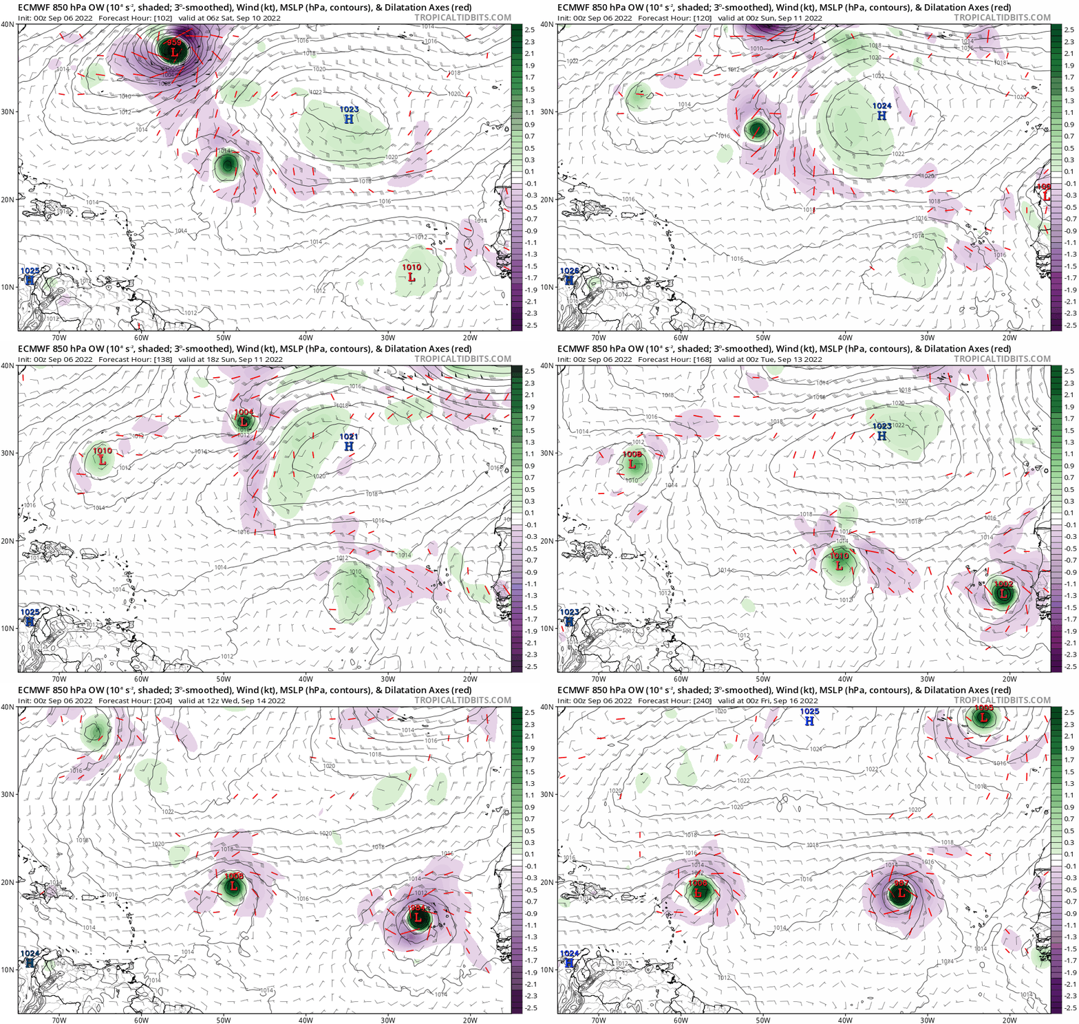
Euro dives this wave wsw at the end of the run.

Image
0 likes   

User avatar
aspen
Category 5
Category 5
Posts: 8056
Joined: Sat Oct 12, 2019 7:10 pm
Location: Connecticut, USA

Re: Tropical Wave inside West Africa

#3 Postby aspen » Tue Sep 06, 2022 7:19 am

SFLcane wrote:Euro dives this wave wsw at the end of the run.

https://i.postimg.cc/pX8GGTpL/A6-BD4-A6-B-9-DB6-4-D23-9-BBD-785-F0-AE789-A1.gif

About half of the 06z GEFS members have a WSW dive too, but it’s all fish this run. The previous GEFS run had multiple members reach MH intensity and directly impact the Caribbean, Bahamas, or Florida.

Also good call pointing out this wave before the models started picking it up.
3 likes   
Irene '11 Sandy '12 Hermine '16 5/15/2018 Derecho Fay '20 Isaias '20 Elsa '21 Henri '21 Ida '21

I am only a meteorology enthusiast who knows a decent amount about tropical cyclones. Look to the professional mets, the NHC, or your local weather office for the best information.

User avatar
cycloneye
Admin
Admin
Posts: 139027
Age: 67
Joined: Thu Oct 10, 2002 10:54 am
Location: San Juan, Puerto Rico

Re: Tropical Wave inside West Africa

#4 Postby cycloneye » Tue Sep 06, 2022 8:01 am

Image
0 likes   
Visit the Caribbean-Central America Weather Thread where you can find at first post web cams,radars
and observations from Caribbean basin members Click Here

User avatar
SFLcane
S2K Supporter
S2K Supporter
Posts: 9606
Age: 46
Joined: Sat Jun 05, 2010 1:44 pm
Location: Lake Worth Florida

Re: Tropical Wave inside West Africa

#5 Postby SFLcane » Tue Sep 06, 2022 8:41 am

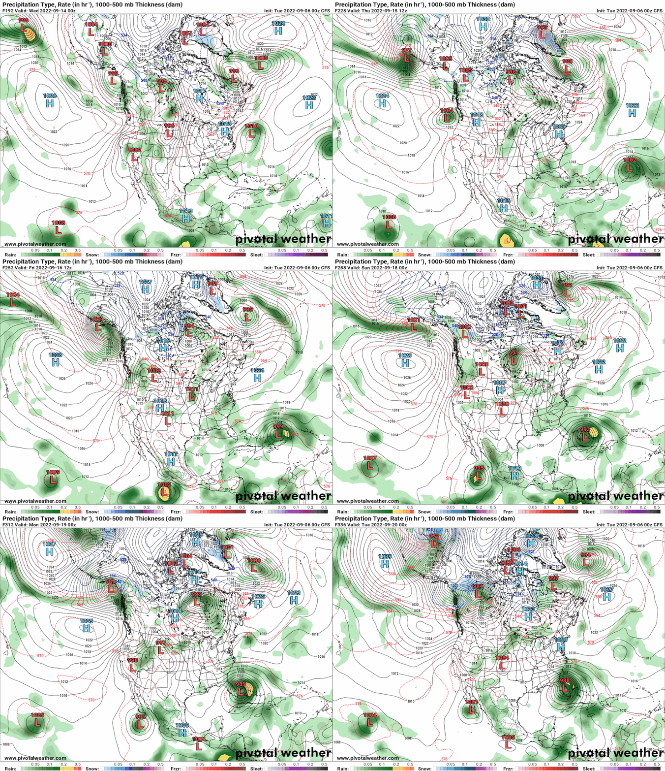
CFS takes new lemon as a strengthening hurricane into SFL. It also has that wsw dive. :double:

** Use with Caution**

Image
1 likes   

LarryWx
Category 5
Category 5
Posts: 5699
Joined: Sun Sep 07, 2003 2:04 pm
Location: GA

Re: Tropical Wave inside West Africa

#6 Postby LarryWx » Tue Sep 06, 2022 11:41 am

The 12Z UKMET is the 5th run in a row to have a TC from this. The Sun 9/4 12Z run UKMET was the first major op model to have this as an actual TC and was soon followed up by others. Will the UKMET end up with kudos? Or will it fail (phantom)? We'll see later:

NEW TROPICAL CYCLONE FORECAST TO DEVELOP AFTER 90 HOURS
FORECAST POSITION AT T+ 90 : 10.5N 30.8W

LEAD CENTRAL MAXIMUM WIND
VERIFYING TIME TIME POSITION PRESSURE (MB) SPEED (KNOTS)
-------------- ---- -------- ------------- -------------
1200UTC 10.09.2022 96 10.9N 31.7W 1010 26
0000UTC 11.09.2022 108 11.8N 35.2W 1010 28
1200UTC 11.09.2022 120 12.4N 38.2W 1009 30
0000UTC 12.09.2022 132 14.1N 40.8W 1007 35
1200UTC 12.09.2022 144 15.5N 43.8W 1006 36

---------------------------------------------------------------
For comparison, here was that first UKMET run picking it up, the Sun 9/4 12Z run:

NEW TROPICAL CYCLONE FORECAST TO DEVELOP AFTER 120 HOURS
FORECAST POSITION AT T+120 : 9.8N 26.4W

LEAD CENTRAL MAXIMUM WIND
VERIFYING TIME TIME POSITION PRESSURE (MB) SPEED (KNOTS)
-------------- ---- -------- ------------- -------------
1200UTC 09.09.2022 120 9.8N 26.4W 1009 26
0000UTC 10.09.2022 132 10.6N 30.4W 1009 29
1200UTC 10.09.2022 144 11.4N 34.2W 1008 33
0 likes   
Personal Forecast Disclaimer:
The posts in this forum are NOT official forecasts and should not be used as such. They are just the opinion of the poster and may or may not be backed by sound meteorological data. They are NOT endorsed by any professional institution or storm2k.org. For official information, please refer to the NHC and NWS products.

User avatar
galaxy401
Category 5
Category 5
Posts: 2298
Age: 28
Joined: Sat Aug 25, 2012 9:04 pm
Location: Casa Grande, Arizona

Re: Tropical Wave inside West Africa

#7 Postby galaxy401 » Tue Sep 06, 2022 12:00 pm

This is the wave the models appear to be more keen on. Could be a long-tracker if it stays south enough early on.
0 likes   
Got my eyes on moving right into Hurricane Alley: Florida.

User avatar
cycloneye
Admin
Admin
Posts: 139027
Age: 67
Joined: Thu Oct 10, 2002 10:54 am
Location: San Juan, Puerto Rico

Re: Tropical Wave inside West Africa

#8 Postby cycloneye » Tue Sep 06, 2022 1:00 pm

African Coast:
A tropical wave currently located over western Africa is forecast to
emerge offshore into the eastern Atlantic in a day or two.
Environmental conditions appear generally conducive for some slow
development thereafter as the system moves west-northwestward over
the eastern tropical Atlantic.
* Formation chance through 48 hours...low...near 0 percent.
* Formation chance through 5 days...low...20 percent
0 likes   
Visit the Caribbean-Central America Weather Thread where you can find at first post web cams,radars
and observations from Caribbean basin members Click Here

User avatar
SFLcane
S2K Supporter
S2K Supporter
Posts: 9606
Age: 46
Joined: Sat Jun 05, 2010 1:44 pm
Location: Lake Worth Florida

Re: Tropical Wave inside West Africa

#9 Postby SFLcane » Tue Sep 06, 2022 2:01 pm

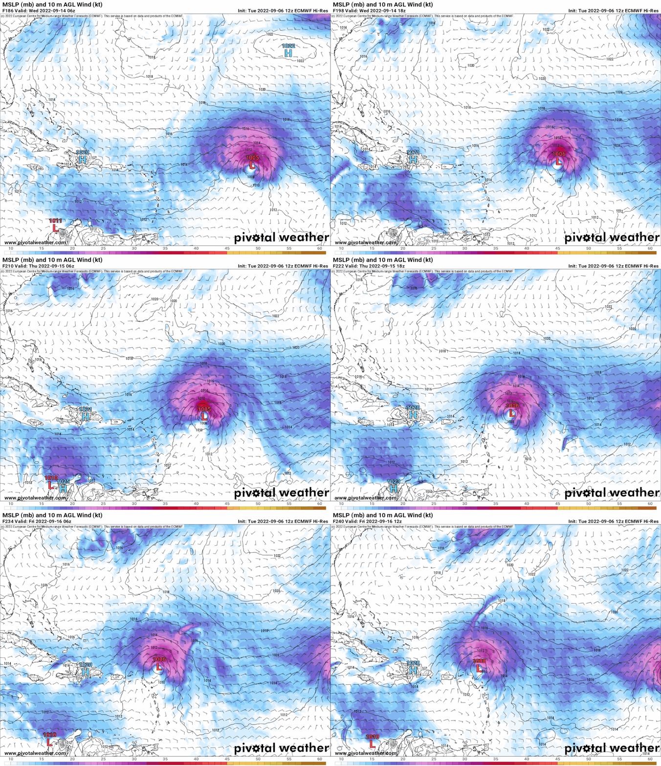
One to watch...

Image
3 likes   

LarryWx
Category 5
Category 5
Posts: 5699
Joined: Sun Sep 07, 2003 2:04 pm
Location: GA

Re: Tropical Wave inside West Africa

#10 Postby LarryWx » Tue Sep 06, 2022 2:14 pm

SFLcane wrote:One to watch...

https://i.postimg.cc/FshCf9jw/ecm.gif


The 12Z GFS and CMC at 240 are in the same general vicinity as the 12Z Euro though with only weak surface reflections. Indeed, something to watch for possibly the E Caribbean in ~10 days and potentially other areas later.
0 likes   
Personal Forecast Disclaimer:
The posts in this forum are NOT official forecasts and should not be used as such. They are just the opinion of the poster and may or may not be backed by sound meteorological data. They are NOT endorsed by any professional institution or storm2k.org. For official information, please refer to the NHC and NWS products.

User avatar
gatorcane
S2K Supporter
S2K Supporter
Posts: 23499
Age: 46
Joined: Sun Mar 13, 2005 3:54 pm
Location: Boca Raton, FL

Re: Tropical Wave inside West Africa

#11 Postby gatorcane » Tue Sep 06, 2022 2:15 pm

The GFS and the CMC are not particularly enthusiastic. In fact since the 00Z GFS, the last two runs basically drop this system. That said, the wave looks good and is exiting more south so bears watching.
0 likes   

User avatar
PTrackerLA
Category 5
Category 5
Posts: 5248
Age: 40
Joined: Thu Oct 10, 2002 8:40 pm
Location: Lafayette, LA

Re: Tropical Wave inside West Africa

#12 Postby PTrackerLA » Tue Sep 06, 2022 2:16 pm

That's 2 runs of the Euro with a dangerous look for days 7-10. 12z Canadian also has a very similar look to the Euro at day 10.

Image
0 likes   

User avatar
SFLcane
S2K Supporter
S2K Supporter
Posts: 9606
Age: 46
Joined: Sat Jun 05, 2010 1:44 pm
Location: Lake Worth Florida

Re: Tropical Wave inside West Africa

#13 Postby SFLcane » Tue Sep 06, 2022 3:18 pm

Image
2 likes   

LarryWx
Category 5
Category 5
Posts: 5699
Joined: Sun Sep 07, 2003 2:04 pm
Location: GA

Re: Tropical Wave inside West Africa

#14 Postby LarryWx » Tue Sep 06, 2022 3:20 pm


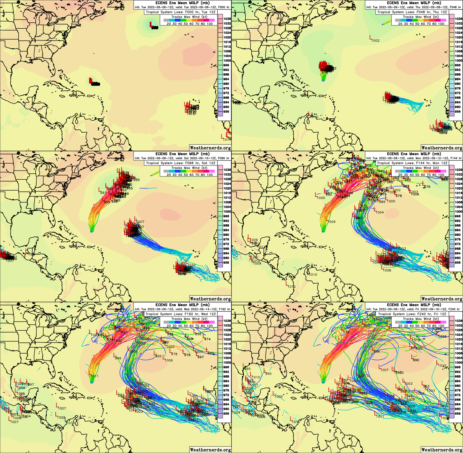
What's worrisome is not only that it is very active with this AEW, but that a good number of members after moving WNW change headings to W near 45W (similar to the operational) ~9/13 and then head W with the accompanying steering high to the north from there through 9/16 to 55-60W in a potentially dangerous position as your animation suggests.
3 likes   
Personal Forecast Disclaimer:
The posts in this forum are NOT official forecasts and should not be used as such. They are just the opinion of the poster and may or may not be backed by sound meteorological data. They are NOT endorsed by any professional institution or storm2k.org. For official information, please refer to the NHC and NWS products.

AutoPenalti
Category 5
Category 5
Posts: 3949
Age: 27
Joined: Mon Aug 17, 2015 4:16 pm
Location: Ft. Lauderdale, Florida

Re: Tropical Wave inside West Africa

#15 Postby AutoPenalti » Tue Sep 06, 2022 3:26 pm

PTrackerLA wrote:12z EPS Control: :eek:

https://imgur.com/0UBKJMJ


Image

It looks to want to stall. Maybe a curve away here. Too close to call this far out but something to watch again.
3 likes   
The posts in this forum are NOT official forecasts and should not be used as such. They are just the opinion of the poster and may or may not be backed by sound meteorological data. They are NOT endorsed by any professional institution or STORM2K. For official information, please refer to products from the NHC and NWS.


Model Runs Cheat Sheet:
GFS (5:30 AM/PM, 11:30 AM/PM)
HWRF, GFDL, UKMET, NAVGEM (6:30-8:00 AM/PM, 12:30-2:00 AM/PM)
ECMWF (1:45 AM/PM)

TCVN
is a weighted averaged

User avatar
SFLcane
S2K Supporter
S2K Supporter
Posts: 9606
Age: 46
Joined: Sat Jun 05, 2010 1:44 pm
Location: Lake Worth Florida

Re: Tropical Wave inside West Africa

#16 Postby SFLcane » Tue Sep 06, 2022 3:47 pm

LarryWx wrote:


What's worrisome is not only that it is very active with this AEW, but that a good number of members after moving WNW change headings to W near 45W (similar to the operational) ~9/13 and then head W with the accompanying steering high to the north from there through 9/16 to 55-60W in a potentially dangerous position as your animation suggests.


Most recurve sharply towards bermuda. Curious to see if/how fast it develops first
3 likes   

User avatar
Teban54
Category 5
Category 5
Posts: 1953
Joined: Sat May 19, 2018 1:19 pm

Re: Tropical Wave inside West Africa

#17 Postby Teban54 » Tue Sep 06, 2022 6:38 pm

AutoPenalti wrote:
PTrackerLA wrote:12z EPS Control: :eek:

https://imgur.com/0UBKJMJ


https://i.imgur.com/0UBKJMJ.gif

It looks to want to stall. Maybe a curve away here. Too close to call this far out but something to watch again.

So it's pre-Earl all over again? :double:
0 likes   

User avatar
cycloneye
Admin
Admin
Posts: 139027
Age: 67
Joined: Thu Oct 10, 2002 10:54 am
Location: San Juan, Puerto Rico

Re: Tropical Wave inside West Africa

#18 Postby cycloneye » Tue Sep 06, 2022 6:44 pm

2. African Coast:
A tropical wave currently located over western Africa is forecast to
emerge offshore into the eastern Atlantic in a day or two.
Environmental conditions appear generally conducive for some slow
development thereafter as the system moves west-northwestward over
the eastern tropical Atlantic.
* Formation chance through 48 hours...low...near 0 percent.
* Formation chance through 5 days...low...20 percent.
0 likes   
Visit the Caribbean-Central America Weather Thread where you can find at first post web cams,radars
and observations from Caribbean basin members Click Here

User avatar
chaser1
S2K Supporter
S2K Supporter
Posts: 4680
Age: 63
Joined: Sat Oct 15, 2005 5:59 pm
Location: Longwood, Fl

Re: Tropical Wave inside West Africa

#19 Postby chaser1 » Tue Sep 06, 2022 8:42 pm

LarryWx wrote:


What's worrisome is not only that it is very active with this AEW, but that a good number of members after moving WNW change headings to W near 45W (similar to the operational) ~9/13 and then head W with the accompanying steering high to the north from there through 9/16 to 55-60W in a potentially dangerous position as your animation suggests.


Hard for me to buy into a Caribbean or CONUS threat for this wave given this season's penchant for recurve tracks. Then again, 1989 does beg to differ (and Hugo didn't form until Sept. 11).
3 likes   
Personal Forecast Disclaimer:
The posts in this forum are NOT official forecast and should not be used as such. They are just the opinion of the poster and may or may not be backed by sound meteorological data. They are NOT endorsed by any professional institution or storm2k.org. For official information, please refer to the NHC and NWS products.


LarryWx
Category 5
Category 5
Posts: 5699
Joined: Sun Sep 07, 2003 2:04 pm
Location: GA

Re: Tropical Wave inside West Africa

#20 Postby LarryWx » Tue Sep 06, 2022 10:38 pm

chaser1 wrote:
LarryWx wrote:


What's worrisome is not only that it is very active with this AEW, but that a good number of members after moving WNW change headings to W near 45W (similar to the operational) ~9/13 and then head W with the accompanying steering high to the north from there through 9/16 to 55-60W in a potentially dangerous position as your animation suggests.


Hard for me to buy into a Caribbean or CONUS threat for this wave given this season's penchant for recurve tracks. Then again, 1989 does beg to differ (and Hugo didn't form until Sept. 11).


Hopefully you're right!

Meanwhile, it appears that the wave may be coming off as I type this. I see something near 13W and it looks rather impressive. Any opinions?
0 likes   
Personal Forecast Disclaimer:
The posts in this forum are NOT official forecasts and should not be used as such. They are just the opinion of the poster and may or may not be backed by sound meteorological data. They are NOT endorsed by any professional institution or storm2k.org. For official information, please refer to the NHC and NWS products.


Return to “Talkin' Tropics”

Who is online

Users browsing this forum: zzzh and 136 guests