Tropical wave east of the Windward Islands (Is Invest 98L)

This is the general tropical discussion area. Anyone can take their shot at predicting a storms path.

Moderator: S2k Moderators

Forum rules

The posts in this forum are NOT official forecasts and should not be used as such. They are just the opinion of the poster and may or may not be backed by sound meteorological data. They are NOT endorsed by any professional institution or STORM2K. For official information, please refer to products from the National Hurricane Center and National Weather Service.

Help Support Storm2K
Message
Author
User avatar
Spacecoast
Category 2
Category 2
Posts: 687
Joined: Thu Aug 31, 2017 2:03 pm

Re: Tropical wave east of the Windward Islands (10/40)

#401 Postby Spacecoast » Tue Sep 20, 2022 6:42 am

toad strangler wrote:
chris_fit wrote:
jlauderdal wrote:I like that track this far out, the trend is also good, let's hope it continues.


Exactly, my thinking as well - This is where you want to be 8-9-10+ days out.


I'm sure there will be E of FL to Hatteras and beyond runs in the coming days.

Image
Last edited by Spacecoast on Tue Sep 20, 2022 7:00 am, edited 1 time in total.
1 likes   

User avatar
Iceresistance
Category 5
Category 5
Posts: 8911
Age: 20
Joined: Sat Oct 10, 2020 9:45 am
Location: Tecumseh, OK/Norman, OK

Re: Tropical wave east of the Windward Islands (10/50)

#402 Postby Iceresistance » Tue Sep 20, 2022 6:46 am

Now at 10/50%

2. Central Tropical Atlantic:
A tropical wave located several hundred miles east of the Windward
Islands is producing a broad area of disorganized showers and
thunderstorms while moving westward at 15-20 mph. Gradual
development of this system is forecast during the next several days
as the system approaches the Windward Islands, and a tropical
depression could form by the latter part of this week as the system
moves into the eastern and central Caribbean sea.
* Formation chance through 48 hours...low...10 percent.
* Formation chance through 5 days...medium...50 percent.
1 likes   
Bill 2015 & Beta 2020

Winter 2020-2021 :cold:

All observations are in Tecumseh, OK unless otherwise noted.

Winter posts are focused mainly for Oklahoma & Texas.

Take any of my forecasts with a grain of salt, refer to the NWS, SPC, and NHC for official information

Never say Never with weather! Because ANYTHING is possible!

AutoPenalti
Category 5
Category 5
Posts: 3949
Age: 27
Joined: Mon Aug 17, 2015 4:16 pm
Location: Ft. Lauderdale, Florida

Re: Tropical wave east of the Windward Islands (10/50)

#403 Postby AutoPenalti » Tue Sep 20, 2022 7:00 am

Wow GFS
0 likes   
The posts in this forum are NOT official forecasts and should not be used as such. They are just the opinion of the poster and may or may not be backed by sound meteorological data. They are NOT endorsed by any professional institution or STORM2K. For official information, please refer to products from the NHC and NWS.


Model Runs Cheat Sheet:
GFS (5:30 AM/PM, 11:30 AM/PM)
HWRF, GFDL, UKMET, NAVGEM (6:30-8:00 AM/PM, 12:30-2:00 AM/PM)
ECMWF (1:45 AM/PM)

TCVN
is a weighted averaged

User avatar
stormchazer
Category 5
Category 5
Posts: 2458
Joined: Fri Aug 29, 2003 12:00 pm
Location: Lakeland, Florida
Contact:

Re: Tropical wave east of the Windward Islands (10/50)

#404 Postby stormchazer » Tue Sep 20, 2022 7:10 am

caneman wrote:
BobHarlem wrote:Tampa bay run here, VERY bad setup for surge if this happens this way. Check that off the long range GFS hit list. Hoping we get an invest designation on this soon for more models.

https://i.imgur.com/qrNSzam.png

https://i.imgur.com/xoQQhwK.png


Dang that would wipe out my home. I live on the little peninsula known as Pinellas county but as others have said, I'd rather the model be on top of us this far out than a few days from now.


Let’s hope this does not verify. This is one of the worse case scenarios for a land falling hurricane and no, Pinellas County not the place to be. You can take shelter with me in Lakeland. Fortunate this is way out in the forecast.
1 likes   

ChrisH-UK
Category 1
Category 1
Posts: 422
Joined: Sat May 29, 2021 8:22 am

Re: Tropical wave east of the Windward Islands (10/50)

#405 Postby ChrisH-UK » Tue Sep 20, 2022 7:12 am

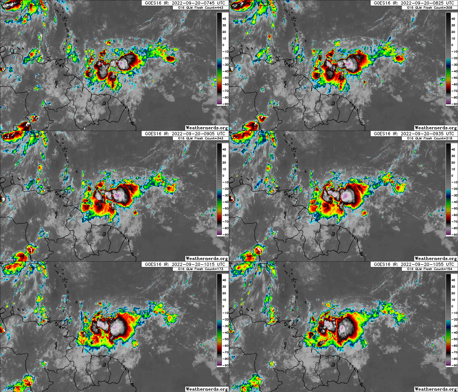
Looks like it has developed well overnight.

2 likes   

User avatar
skyline385
Category 5
Category 5
Posts: 2444
Age: 33
Joined: Wed Aug 26, 2020 11:15 pm
Location: Palm Beach County FL

Re: Tropical wave east of the Windward Islands (10/50)

#406 Postby skyline385 » Tue Sep 20, 2022 7:18 am

GFS really out for Tampa this run huh

Image


Sent from my iPhone using Tapatalk
0 likes   

JPmia
S2K Supporter
S2K Supporter
Posts: 1070
Joined: Thu Jun 03, 2004 11:01 pm
Location: Fort Lauderdale, FL

Re: Tropical wave east of the Windward Islands (10/50)

#407 Postby JPmia » Tue Sep 20, 2022 7:22 am

SFLcane wrote:Gfs similar to its ensembles for now. Just makes sense in my opinion based on climo alone. Long way to go

https://i.postimg.cc/9Q25V0Pn/C9857-F93-EE13-432-B-BE91-8863-A856-C899.png

That looks like WIlma just a few miles west.
0 likes   

Deshaunrob17
Tropical Storm
Tropical Storm
Posts: 180
Joined: Tue Aug 18, 2020 7:49 am

Re: Tropical wave east of the Windward Islands (10/50)

#408 Postby Deshaunrob17 » Tue Sep 20, 2022 7:33 am

Let’s take it step by step.. Firstly, Trinidad and Tobago/ Southern Windwards. I had my doubts yesterday with the GfS but based on satellite presentation this morning , I’m let to wonder!! GfS has shown a strong ts moving over T &T for a while now. This is a country that’s not used to these winds!!! That could be a problem!!! Flooding too!
3 likes   

User avatar
SFLcane
S2K Supporter
S2K Supporter
Posts: 9606
Age: 46
Joined: Sat Jun 05, 2010 1:44 pm
Location: Lake Worth Florida

Re: Tropical wave east of the Windward Islands (10/50)

#409 Postby SFLcane » Tue Sep 20, 2022 7:36 am

If the Gefs ensembles have a say there could be more eastward shifts in time. We’ll see
0 likes   

User avatar
toad strangler
S2K Supporter
S2K Supporter
Posts: 4162
Joined: Sun Jul 28, 2013 3:09 pm
Location: Earth
Contact:

Re: Tropical wave east of the Windward Islands (10/50)

#410 Postby toad strangler » Tue Sep 20, 2022 7:41 am

SFLcane wrote:If the Gefs ensembles have a say there could be more eastward shifts in time. We’ll see


I'm sure there will be. There will be windshield wipers going on until we have an established system. All these solutions are pure entertainment, or horror. For now.
0 likes   

tomatkins
Tropical Storm
Tropical Storm
Posts: 220
Joined: Wed Sep 05, 2018 2:11 pm

Re: Tropical wave east of the Windward Islands (10/50)

#411 Postby tomatkins » Tue Sep 20, 2022 7:43 am

ChrisH-UK wrote:Looks like it has developed well overnight.

https://imgur.com/lHtswob

I guess the only way a storm can develop this year is to be super far south.
1 likes   

User avatar
ronjon
Category 5
Category 5
Posts: 4671
Joined: Fri Aug 19, 2005 5:17 pm
Location: Hernando Beach, FL

Re: Tropical wave east of the Windward Islands (10/50)

#412 Postby ronjon » Tue Sep 20, 2022 7:45 am

SFLcane wrote:If the Gefs ensembles have a say there could be more eastward shifts in time. We’ll see


Wouldn't be surprised with strong east coast troughing basically all summer. Let's hope so. Been down this road before. I won't get nervous until we're in that 5 day forecast window. Even then, look what happened with Charlie and Irma when even short term predictions had each storm running up to Tampa or just offshore the FL west coast and the trough turned them northeast into the peninsula over south FL.
1 likes   

User avatar
SoupBone
Category 5
Category 5
Posts: 3073
Joined: Tue Sep 20, 2005 5:24 pm

Re: Tropical wave east of the Windward Islands (10/40)

#413 Postby SoupBone » Tue Sep 20, 2022 7:50 am

wxman57 wrote:Unfortunately, this disturbance could be trouble for the eastern Gulf (Florida) in 8-9 days. Definitely not Charley, as this could be larger. I'm not so confident where it will really go yet. If it's slower to develop and weaker, it may crash into Central America. That's the best we could hope for. I think it'll most likely become a depression next Sun/Mon as it passes south of Jamaica. Look for NHC probabilities to steadily climb as that development point falls within 5 days and if models don't change. If I lived anywhere in Florida or on the northern Gulf Coast, I'd check my hurricane supplies now before the panic starts.


You consider Houston on the northern gulf coast?
0 likes   
Personal Forecast Disclaimer:
The posts in this forum are NOT official forecast and should not be used as such. They are just the opinion of the poster and may or may not be backed by sound meteorological data. They are NOT endorsed by any professional institution or storm2k.org. For official information, please refer to the NHC and NWS products.

OuterBanker
S2K Supporter
S2K Supporter
Posts: 1704
Joined: Wed Feb 26, 2003 10:53 am
Location: Nags Head, NC
Contact:

Re: Tropical wave east of the Windward Islands (10/50)

#414 Postby OuterBanker » Tue Sep 20, 2022 7:51 am

Is this now 98L?
0 likes   

User avatar
Stormybajan
Category 1
Category 1
Posts: 428
Joined: Thu May 20, 2021 3:21 pm
Location: Windward Islands

Re: Tropical wave east of the Windward Islands (10/50)

#415 Postby Stormybajan » Tue Sep 20, 2022 7:53 am

Deshaunrob17 wrote:Let’s take it step by step.. Firstly, Trinidad and Tobago/ Southern Windwards. I had my doubts yesterday with the GfS but based on satellite presentation this morning , I’m let to wonder!! GfS has shown a strong ts moving over T &T for a while now. This is a country that’s not used to these winds!!! That could be a problem!!! Flooding too!

Yepppp very well said! Looks like its gonna hug that 10N - 11N line and produce some flooding issues for Grenada and T&T. Couldve been worse for the other windward islands if Fiona's outflow wasnt squishing it, as it is right now! I dont really believe it can be named before the islands but I still think a TD or PTC is a possibility. Im very surprised this isnt an invest yet as it will start to affect the islands tomorrow... #wheres98L :roll:
LMAO: Not even 1 minute after posting this apparently our tropical wave is now 98L, just my luck :roll: :roll:
Last edited by Stormybajan on Tue Sep 20, 2022 7:58 am, edited 3 times in total.
0 likes   
Sad West Indies and Manchester United fan ⚽️

User avatar
pgoss11
Category 2
Category 2
Posts: 702
Joined: Tue Sep 02, 2003 3:55 pm

Re: Tropical wave east of the Windward Islands (10/50)

#416 Postby pgoss11 » Tue Sep 20, 2022 7:54 am

OuterBanker wrote:Is this now 98L?

I would think very soon.
0 likes   

User avatar
toad strangler
S2K Supporter
S2K Supporter
Posts: 4162
Joined: Sun Jul 28, 2013 3:09 pm
Location: Earth
Contact:

Re: Tropical wave east of the Windward Islands (10/50)

#417 Postby toad strangler » Tue Sep 20, 2022 7:54 am

OuterBanker wrote:Is this now 98L?


Sure looks like it.
0 likes   

User avatar
CourierPR
Category 5
Category 5
Posts: 1325
Age: 70
Joined: Tue Aug 31, 2004 7:53 pm
Location: Pompano Beach, Florida

Re: Tropical wave east of the Windward Islands (10/50)

#418 Postby CourierPR » Tue Sep 20, 2022 7:54 am

Meteorologist Joe Bastardi is telling residents along the central and eastern Gulf coast, and Florida to be on alert for this one.
0 likes   

User avatar
SFLcane
S2K Supporter
S2K Supporter
Posts: 9606
Age: 46
Joined: Sat Jun 05, 2010 1:44 pm
Location: Lake Worth Florida

Re: Tropical wave east of the Windward Islands (10/50)

#419 Postby SFLcane » Tue Sep 20, 2022 7:56 am

Impressive…

Image
2 likes   

User avatar
skyline385
Category 5
Category 5
Posts: 2444
Age: 33
Joined: Wed Aug 26, 2020 11:15 pm
Location: Palm Beach County FL

Re: Tropical wave east of the Windward Islands (10/50)

#420 Postby skyline385 » Tue Sep 20, 2022 8:00 am

Stormybajan wrote:
Deshaunrob17 wrote:Let’s take it step by step.. Firstly, Trinidad and Tobago/ Southern Windwards. I had my doubts yesterday with the GfS but based on satellite presentation this morning , I’m let to wonder!! GfS has shown a strong ts moving over T &T for a while now. This is a country that’s not used to these winds!!! That could be a problem!!! Flooding too!

Yepppp very well said! Looks like its gonna hug that 10N - 11N line and produce some flooding issues for Grenada and T&T. Couldve been worse for the other windward islands if Fiona's outflow wasnt squishing it, as it is right now! I dont really believe it can be named before the islands but I still think a TD or PTC is a possibility. Im very surprised this isnt an invest yet as it will start to affect the islands tomorrow... #wheres98L :roll:

Lmao:[b]Not even 1 minute after posting this apparently our tropical wave is now 98L[b] :roll: :roll:


Seriously doubt the GFS is going to verify with a TS that quick, all other models show it as an open wave and I am sure T&T can handle some winds. Rain might be a threat but not much you can get from a TW.
Last edited by skyline385 on Tue Sep 20, 2022 8:05 am, edited 1 time in total.
1 likes   


Return to “Talkin' Tropics”

Who is online

Users browsing this forum: No registered users and 104 guests