2023 Indicators (SST, SAL, MSLP, Wind shear, Steering, Instability) and Day 16+ Models
Moderator: S2k Moderators
Forum rules
The posts in this forum are NOT official forecasts and should not be used as such. They are just the opinion of the poster and may or may not be backed by sound meteorological data. They are NOT endorsed by any professional institution or STORM2K. For official information, please refer to products from the National Hurricane Center and National Weather Service.
- Category5Kaiju
- Category 5
- Posts: 3360
- Age: 22
- Joined: Thu Dec 24, 2020 12:45 pm
- Location: Seattle
Re: 2023 Indicators (SST, SAL, MSLP, Wind shear, Steering, Instability) and Day 16+ Models
While we wait for the tropics to heat up again, I'm going to post this in anticipation of the inevitable.
Happy 10-year anniversary.
10 likes
Unless explicitly stated, all information covered in my posts is based on my opinions and observations. Please refer to a professional meteorologist or an accredited weather research agency otherwise, especially if serious decisions must be made in the event of a potentially life-threatening tropical storm or hurricane.
- cycloneye
- Admin
- Posts: 139142
- Age: 67
- Joined: Thu Oct 10, 2002 10:54 am
- Location: San Juan, Puerto Rico
Re: 2023 Indicators (SST, SAL, MSLP, Wind shear, Steering, Instability) and Day 16+ Models
3 likes
Visit the Caribbean-Central America Weather Thread where you can find at first post web cams,radars
and observations from Caribbean basin members Click Here
- toad strangler
- S2K Supporter
- Posts: 4162
- Joined: Sun Jul 28, 2013 3:09 pm
- Location: Earth
- Contact:
- ScottNAtlanta
- Category 5
- Posts: 1999
- Joined: Sat May 25, 2013 3:11 pm
- Location: Atlanta, GA
Re: 2023 Indicators (SST, SAL, MSLP, Wind shear, Steering, Instability) and Day 16+ Models
Don't forget Dennis and Emily were early Majors in 2005. We have more warmth now than we did then
https://twitter.com/catinsight/status/1667875462553518080
0 likes
The posts in this forum are NOT official forecast and should not be used as such. They are just the opinion of the poster and may or may not be backed by sound meteorological data. They are NOT endorsed by any professional institution or storm2k.org. For official information, please refer to the NHC and NWS products.
Re: 2023 Indicators (SST, SAL, MSLP, Wind shear, Steering, Instability) and Day 16+ Models
Here comes the WAM.
7 likes
- Category5Kaiju
- Category 5
- Posts: 3360
- Age: 22
- Joined: Thu Dec 24, 2020 12:45 pm
- Location: Seattle
Re: 2023 Indicators (SST, SAL, MSLP, Wind shear, Steering, Instability) and Day 16+ Models
zzzh wrote:https://i.imgur.com/VzyHS2S.gif
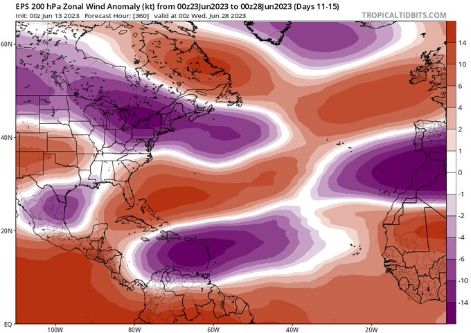
Here comes the WAM.
At this point I wouldn't be surprised if by the end of this month the sst anomaly maps show the MDR blood-red with isolated speckles of black.
3 likes
Unless explicitly stated, all information covered in my posts is based on my opinions and observations. Please refer to a professional meteorologist or an accredited weather research agency otherwise, especially if serious decisions must be made in the event of a potentially life-threatening tropical storm or hurricane.
-
- Category 5
- Posts: 2414
- Joined: Sun Aug 12, 2007 3:45 am
- Location: Florida State University
Re: 2023 Indicators (SST, SAL, MSLP, Wind shear, Steering, Instability) and Day 16+ Models
OuterBanker wrote: I do wonder one thing though. With the MDR at ASO temps will we have an early CV season. Or, are Conditions there still to hostel?
We haven't seen many vigorous African Easterly Waves (AEWs) in addition to their launch point having been too far south (most of the waves have had their axis running into SA). The Africa InterTropical Front (ITF) has been anomalously positioned to the south, but is starting to make its seasonal traverse to the north:
To get a bit more technical, one reason for this is that AEWs along the Sahel-Sahara border intensify in response to radiative forcing, with a maxima between 15N and 25N (which the ITF has been positioned south of). This is in response to a weakened African Easterly Jet (AEJ) and at present absent WAM (as others have posted, long ranges models are showing a shift in the coming weeks). This has also led to a significant decrease in the mixing and dispersion of the Saharan Air Layer (SAL) as well:
In addition, the formation and evolution of AEWs and their associated convection is influenced heavily by the topography of Africa, and more explicitly the Ethiopian Highlands and Darfur Mountains to the east, where the elevated terrain influences the dynamics of the atmospheric flow. One sign of vigorous AEWs is the meridional flow in this region (stronger meridional flow = more upward motion = convective activity in the area AEWs form), and as we can see in current anomaly charts from May 9th - June 9th, the meridional flow has been anomalously weak in this region:
8 likes
Re: 2023 Indicators (SST, SAL, MSLP, Wind shear, Steering, Instability) and Day 16+ Models
Very likely related to the record warm tropical Atlantic for this time of year, San Juan has just had its warmest June 1-11 on record, 86.9 F. Furthermore, it is the warmest by a good margin. The old record warmth was down at 85.3, set in 1988. The record coolest is 77.5, set in 1922, 1913, 1914, and 1939.
https://www.weather.gov/wrh/Climate?wfo=sju
They've had a mere 0.02" of rainfall so far this month, 1% of their normal of 1.87" for June 1-11.
The record warm tropical Atlantic is at least partially being blamed on near record low for this time of year Saharan dust being blown into the Atlantic as Toad Strangler posted.
1 likes
Personal Forecast Disclaimer:
The posts in this forum are NOT official forecasts and should not be used as such. They are just the opinion of the poster and may or may not be backed by sound meteorological data. They are NOT endorsed by any professional institution or storm2k.org. For official information, please refer to the NHC and NWS products.
-
- Tropical Storm
- Posts: 217
- Age: 34
- Joined: Tue Jul 07, 2020 7:29 am
- Location: Isabela, Puerto Rico
Re: 2023 Indicators (SST, SAL, MSLP, Wind shear, Steering, Instability) and Day 16+ Models
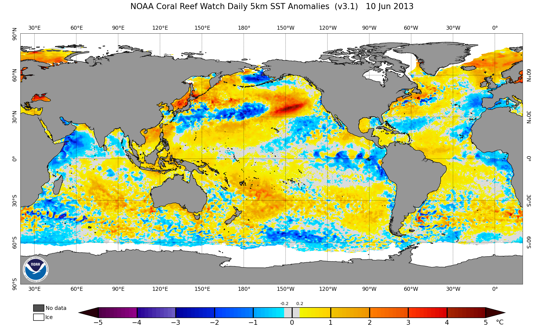
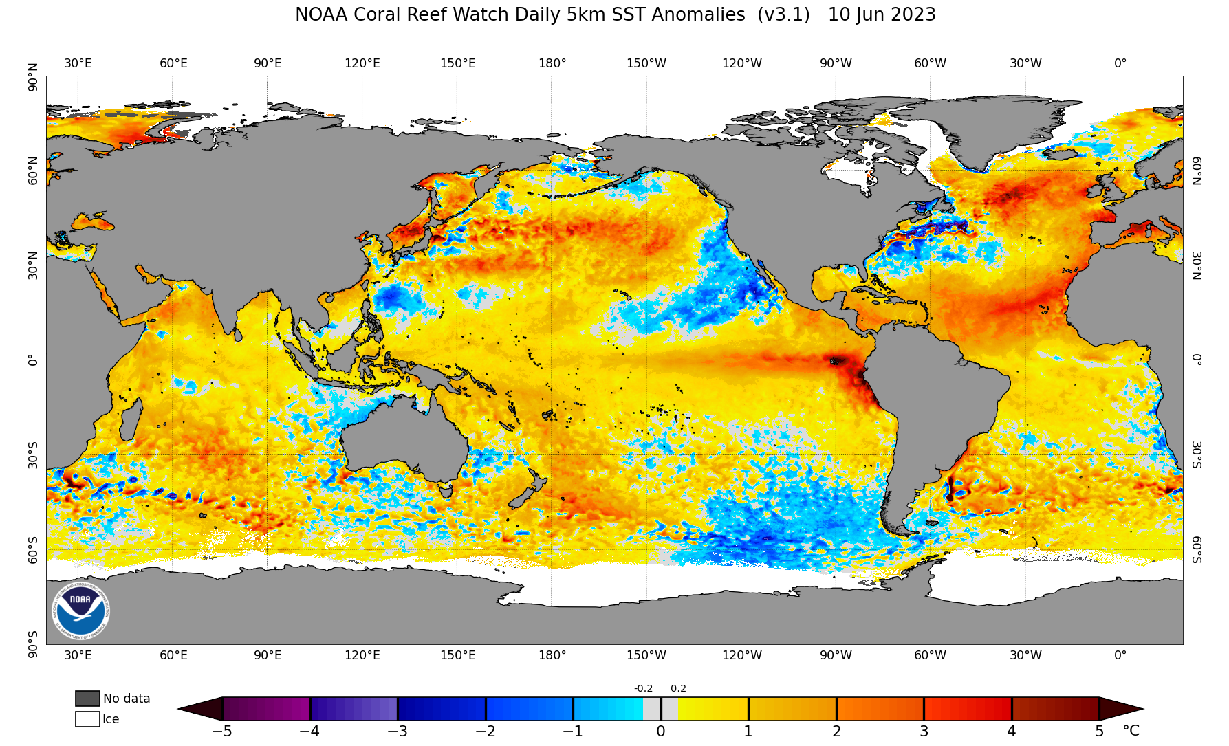
LarryWx wrote:Very likely related to the record warm tropical Atlantic for this time of year, San Juan has just had its warmest June 1-11 on record, 86.9 F. Furthermore, it is the warmest by a good margin. The old record warmth was down at 85.3, set in 1988. The record coolest is 77.5, set in 1922, 1913, 1914, and 1939.
https://www.weather.gov/wrh/Climate?wfo=sju
They've had a mere 0.02" of rainfall so far this month, 1% of their normal of 1.87" for June 1-11.
The record warm tropical Atlantic is at least partially being blamed on near record low for this time of year Saharan dust being blown into the Atlantic as Toad Strangler posted.
Yes, it has been so hot here. There has been an excessive heat warning nearly every day since June 1, I think. Could be an interesting next few months. Today is the first day in like 3 weeks that we have white caps on the ocean.
3 likes
- DorkyMcDorkface
- Category 2
- Posts: 707
- Age: 26
- Joined: Mon Sep 30, 2019 1:32 pm
- Location: Mid-Atlantic
Re: 2023 Indicators (SST, SAL, MSLP, Wind shear, Steering, Instability) and Day 16+ Models
0 likes
Floyd 1999 | Isabel 2003 | Hanna 2008 | Irene 2011 | Sandy 2012 | Isaias 2020
- Category5Kaiju
- Category 5
- Posts: 3360
- Age: 22
- Joined: Thu Dec 24, 2020 12:45 pm
- Location: Seattle
Re: 2023 Indicators (SST, SAL, MSLP, Wind shear, Steering, Instability) and Day 16+ Models
Even if it's just a weak TS, the fact that we're tracking the possibility of a storm forming in the MDR in June in a robust El Nino year is quite alarming. This isn't something you see in every El Nino year, let alone many Atlantic hurricane seasons in general regardless of ENSO state.
10 likes
Unless explicitly stated, all information covered in my posts is based on my opinions and observations. Please refer to a professional meteorologist or an accredited weather research agency otherwise, especially if serious decisions must be made in the event of a potentially life-threatening tropical storm or hurricane.
- SFLcane
- S2K Supporter
- Posts: 9609
- Age: 46
- Joined: Sat Jun 05, 2010 1:44 pm
- Location: Lake Worth Florida
Re: 2023 Indicators (SST, SAL, MSLP, Wind shear, Steering, Instability) and Day 16+ Models
Category5Kaiju wrote:Even if it's just a weak TS, the fact that we're tracking the possibility of a storm forming in the MDR in June in a robust El Nino year is quite alarming. This isn't something you see in every El Nino year, let alone many Atlantic hurricane seasons in general regardless of ENSO state.
It can be a sign that overall conditions are favorable
5 likes
- JetFuel_SE
- Category 1
- Posts: 268
- Age: 24
- Joined: Thu Apr 30, 2020 3:57 pm
- weeniepatrol
- Category 3
- Posts: 858
- Joined: Sat Aug 22, 2020 5:30 pm
- Location: WA State
Re: 2023 Indicators (SST, SAL, MSLP, Wind shear, Steering, Instability) and Day 16+ Models
Yes, something is extremely off about this year if we get June MDR tcs and not Epac tcs during a very-soon-to-be-moderate El Niño
I’ll believe it when I see it, but it would confirm my hunches
3 likes
Re: 2023 Indicators (SST, SAL, MSLP, Wind shear, Steering, Instability) and Day 16+ Models
posting for first time this season, very rare to see this in June. when you have MDR activity this early its definitely a strong indicator for very active season. if i remember correctly june 2020 also had waves rolling this early. this year is an anomaly all together. everything we know or thought we knew about el nino is being tested in full!
1 likes
- JetFuel_SE
- Category 1
- Posts: 268
- Age: 24
- Joined: Thu Apr 30, 2020 3:57 pm
Re: 2023 Indicators (SST, SAL, MSLP, Wind shear, Steering, Instability) and Day 16+ Models
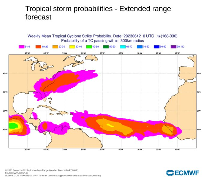
St0rmTh0r wrote:posting for first time this season, very rare to see this in June. when you have MDR activity this early its definitely a strong indicator for very active season. if i remember correctly june 2020 also had waves rolling this early. this year is an anomaly all together. everything we know or thought we knew about el nino is being tested in full!
Actually, 2020 did not see MDR activity in June. But we did see many attempts at early-season MDR storms in recent years:
- 2020: Gonzalo formed in central MDR on July 22. All prior systems were not from AEWs.
- 2021: Elsa formed in western MDR on June 30, and became a hurricane on July 2.
- 2022: Bonnie was expected to form in western MDR in late June with strong model support. However, it took a more southernly track than expected, and therefore could not close off a circulation until July 1 when it reached WCar. It still ended up being an early season storm originated from an AEW.
- 2023: Model support for central MDR in late June. Who knows?
Several forum members have done analyses on early season MDR storms and AEW-based storms in the past 3 years. Both have high correlation with seasonal activity: a July MDR storm is often associated with above-average and even hyperactive seasons. In that sense, 2022 actually underperformed. (2021 to some extent too, compared to other seasons with a July MDR hurricane.)
4 likes
- Category5Kaiju
- Category 5
- Posts: 3360
- Age: 22
- Joined: Thu Dec 24, 2020 12:45 pm
- Location: Seattle
Re: 2023 Indicators (SST, SAL, MSLP, Wind shear, Steering, Instability) and Day 16+ Models
El Nino, meet El Padre.
7 likes
Unless explicitly stated, all information covered in my posts is based on my opinions and observations. Please refer to a professional meteorologist or an accredited weather research agency otherwise, especially if serious decisions must be made in the event of a potentially life-threatening tropical storm or hurricane.
Re: 2023 Indicators (SST, SAL, MSLP, Wind shear, Steering, Instability) and Day 16+ Models
Interesting how the northeast Gulf has been below normal.
0 likes
Who is online
Users browsing this forum: duilaslol, Long John, StPeteMike and 153 guests