2023 Indicators (SST, SAL, MSLP, Wind shear, Steering, Instability) and Day 16+ Models

This is the general tropical discussion area. Anyone can take their shot at predicting a storms path.

Moderator: S2k Moderators

Forum rules

The posts in this forum are NOT official forecasts and should not be used as such. They are just the opinion of the poster and may or may not be backed by sound meteorological data. They are NOT endorsed by any professional institution or STORM2K. For official information, please refer to products from the National Hurricane Center and National Weather Service.

Help Support Storm2K
Message
Author
User avatar
Hurricane2022
Category 4
Category 4
Posts: 911
Joined: Tue Aug 23, 2022 11:38 pm
Location: Araçatuba, Brazil

Re: 2023 Indicators (SST, SAL, MSLP, Wind shear, Steering, Instability) and Day 16+ Models

#521 Postby Hurricane2022 » Thu Jun 08, 2023 9:12 pm

weeniepatrol wrote:


I mean, if wasn't El Nino here i'm 90 - 99% certain that 2023 would be the most active NATL season on record, surpassing 2020/2005 in TC numbers and 1933 in ACE points, not just because that waters are severely warm already in June.

.....We're VERY lucky for not having an Niña today.
2 likes   
Sorry for the bad English sometimes...!
For reliable and detailed information for any meteorological phenomenon, please consult the National Hurricane Center, Joint Typhoon Warning Center , or your local Meteo Center.

--------

Una cvm Christo, pro Christo, et in Christo. Sit nomen Domini benedictvm.

User avatar
Teban54
Category 5
Category 5
Posts: 1952
Joined: Sat May 19, 2018 1:19 pm

Re: 2023 Indicators (SST, SAL, MSLP, Wind shear, Steering, Instability) and Day 16+ Models

#522 Postby Teban54 » Thu Jun 08, 2023 9:49 pm

Hurricane2022 wrote:

I mean, if wasn't El Nino here i'm 90 - 99% certain that 2023 would be the most active NATL season on record, surpassing 2020/2005 in TC numbers and 1933 in ACE points, not just because that waters are severely warm already in June.

.....We're VERY lucky for not having an Niña today.

FWIW, SSTs alone don't dictate seasonal activity. 2010 had the #1 or #2 warmest Atlantic MDR SSTAs on record and had a developing La Nina, yet the season "barely" reached hyperactive ACE threshold, falling well behind 2004 and 2005 in ACE, and behind 2005 and 2020 in storm counts.
8 likes   

zzzh
Category 2
Category 2
Posts: 523
Joined: Thu Sep 02, 2021 1:13 pm

Re: 2023 Indicators (SST, SAL, MSLP, Wind shear, Steering, Instability) and Day 16+ Models

#523 Postby zzzh » Thu Jun 08, 2023 10:52 pm


2023 has a decent meridional SST gradient, unlike years like 2021 where 26C went from 15N to 30N.
Instability will definitely be favored in the deep tropics this year.
3 likes   

User avatar
Blown Away
S2K Supporter
S2K Supporter
Posts: 9861
Joined: Wed May 26, 2004 6:17 am

Re: 2023 Indicators (SST, SAL, MSLP, Wind shear, Steering, Instability) and Day 16+ Models

#524 Postby Blown Away » Fri Jun 09, 2023 7:16 am

Image
CFS
Image
NMME

Conditions near the NE Caribbean, Bahamas, and CONUS dry out moving into September. July & August may be this seasons active months which would be typical for a Nino year. SFL's action during Nino years tends to be in August. JMHO
3 likes   
Hurricane Eye Experience: David 79, Irene 99, Frances 04, Jeanne 04, Wilma 05...
Hurricane Brush Experience: Andrew 92, Erin 95, Floyd 99, Matthew 16, Irma 17, Ian 22, Nicole 22…

User avatar
SFLcane
S2K Supporter
S2K Supporter
Posts: 9606
Age: 46
Joined: Sat Jun 05, 2010 1:44 pm
Location: Lake Worth Florida

Re: 2023 Indicators (SST, SAL, MSLP, Wind shear, Steering, Instability) and Day 16+ Models

#525 Postby SFLcane » Fri Jun 09, 2023 9:47 am

The longer we go without seeing trade winds increase in the Atlantic, the more concerning it becomes for later hurricane season activity. It’s something we’ll be following closely in the months ahead.

https://michaelrlowry.substack.com/p/el ... an-it-tame
2 likes   

User avatar
Stormybajan
Category 1
Category 1
Posts: 428
Joined: Thu May 20, 2021 3:21 pm
Location: Windward Islands

Re: 2023 Indicators (SST, SAL, MSLP, Wind shear, Steering, Instability) and Day 16+ Models

#526 Postby Stormybajan » Fri Jun 09, 2023 11:01 am

A motnh ago, April 28th I said 2023 was trailing 2005 and a distance behind 2010, welp in terms of EAST ATLANTIC Heat 10N-20N from 20W-60W...I think we have to crown a new champion!! There is a 3 DEGREE above average warmpool in the 30W-40W area...INSANE!!! . Idk what this season will bring but if its anything below my 13-6-2 prediction ill be SHOCKED. Even if this season isnt active...all the more fuel for next season when Nino is no more :double: :double: :double:
Image
Image
Image
8 likes   
Sad West Indies and Manchester United fan ⚽️

User avatar
cycloneye
Admin
Admin
Posts: 139025
Age: 67
Joined: Thu Oct 10, 2002 10:54 am
Location: San Juan, Puerto Rico

Re: 2023 Indicators (SST, SAL, MSLP, Wind shear, Steering, Instability) and Day 16+ Models

#527 Postby cycloneye » Fri Jun 09, 2023 11:11 am

0 likes   
Visit the Caribbean-Central America Weather Thread where you can find at first post web cams,radars
and observations from Caribbean basin members Click Here

Monsoonjr99
Tropical Storm
Tropical Storm
Posts: 208
Age: 24
Joined: Fri Sep 21, 2018 11:22 pm
Location: Inland Empire, SoCal

Re: 2023 Indicators (SST, SAL, MSLP, Wind shear, Steering, Instability) and Day 16+ Models

#528 Postby Monsoonjr99 » Fri Jun 09, 2023 1:50 pm

Could the wildfire smoke potentially cause cooling in the subtropics?
0 likes   
The posts in this forum are NOT official forecasts and should not be used as such. They are just the opinion of the poster and may or may not be backed by sound meteorological data. They are NOT endorsed by any professional institution or STORM2K. For official information, please refer to products from the NHC and NWS.

Some Californian who codes things and tracks weather.

Kay '22, Hilary '23

zzzh
Category 2
Category 2
Posts: 523
Joined: Thu Sep 02, 2021 1:13 pm

Re: 2023 Indicators (SST, SAL, MSLP, Wind shear, Steering, Instability) and Day 16+ Models

#529 Postby zzzh » Sat Jun 10, 2023 11:39 am

 https://twitter.com/catinsight/status/1667521998682226690


2010 is now dethroned. In the future we will compare MDR SST with 2023 :lol:
2 likes   

hurricanes1234
Category 5
Category 5
Posts: 2903
Joined: Sat Jul 28, 2012 6:19 pm
Location: Trinidad and Tobago

Re: 2023 Indicators (SST, SAL, MSLP, Wind shear, Steering, Instability) and Day 16+ Models

#530 Postby hurricanes1234 » Sat Jun 10, 2023 12:02 pm

One week apart.

Image
7 likes   
PLEASE NOTE: With the exception of information from weather agencies that I may copy and paste here, my posts will NEVER be official, since I am NOT a meteorologist. They are solely my amateur opinion, and may or may not be accurate. Therefore, please DO NOT use them as official details, particularly when making important decisions. Thank you.


User avatar
Hypercane_Kyle
Category 5
Category 5
Posts: 2899
Joined: Sat Mar 07, 2015 7:58 pm
Location: Cape Canaveral, FL

Re: 2023 Indicators (SST, SAL, MSLP, Wind shear, Steering, Instability) and Day 16+ Models

#532 Postby Hypercane_Kyle » Sat Jun 10, 2023 1:19 pm

El Nino may prevent a 2005-like season, but no doubt if a storm finds itself in a position with favorable upper-level winds, it will turn into a monster.

 https://twitter.com/EliotJacobson/status/1667571728984461312


1 likes   
My posts are my own personal opinion, defer to the National Hurricane Center (NHC) and other NOAA products for decision making during hurricane season.

User avatar
cycloneye
Admin
Admin
Posts: 139025
Age: 67
Joined: Thu Oct 10, 2002 10:54 am
Location: San Juan, Puerto Rico

Re: 2023 Indicators (SST, SAL, MSLP, Wind shear, Steering, Instability) and Day 16+ Models

#533 Postby cycloneye » Sat Jun 10, 2023 2:19 pm

4 likes   
Visit the Caribbean-Central America Weather Thread where you can find at first post web cams,radars
and observations from Caribbean basin members Click Here

User avatar
SFLcane
S2K Supporter
S2K Supporter
Posts: 9606
Age: 46
Joined: Sat Jun 05, 2010 1:44 pm
Location: Lake Worth Florida

Re: 2023 Indicators (SST, SAL, MSLP, Wind shear, Steering, Instability) and Day 16+ Models

#534 Postby SFLcane » Sat Jun 10, 2023 2:44 pm


If this is not an eye opener of what is to come not sure what will do. Look at the precip over the mdr! :eek:
5 likes   

MarioProtVI
Category 2
Category 2
Posts: 669
Age: 22
Joined: Sun Sep 29, 2019 7:33 pm
Location: New Jersey

Re: 2023 Indicators (SST, SAL, MSLP, Wind shear, Steering, Instability) and Day 16+ Models

#535 Postby MarioProtVI » Sat Jun 10, 2023 4:18 pm

Hypercane_Kyle wrote:El Nino may prevent a 2005-like season, but no doubt if a storm finds itself in a position with favorable upper-level winds, it will turn into a monster.

https://twitter.com/EliotJacobson/status/1667571728984461312

1969 had a moderate El Niño IIRC and that season ended up being very active.
1 likes   

User avatar
Category5Kaiju
Category 5
Category 5
Posts: 3351
Age: 22
Joined: Thu Dec 24, 2020 12:45 pm
Location: Seattle

Re: 2023 Indicators (SST, SAL, MSLP, Wind shear, Steering, Instability) and Day 16+ Models

#536 Postby Category5Kaiju » Sat Jun 10, 2023 4:47 pm

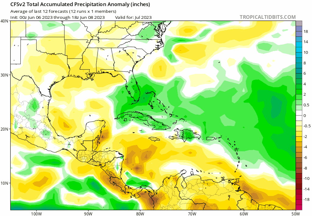
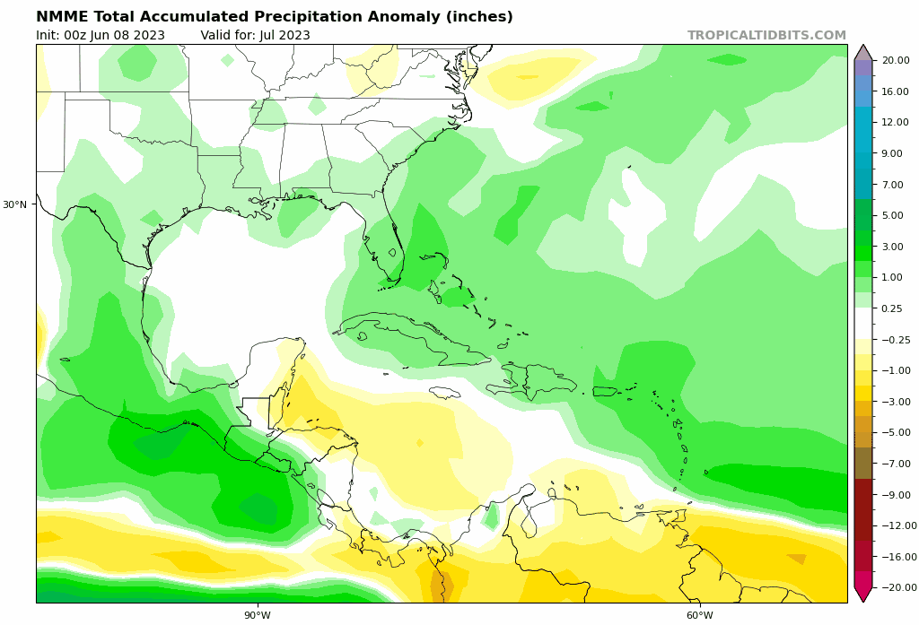
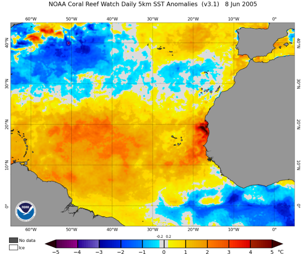
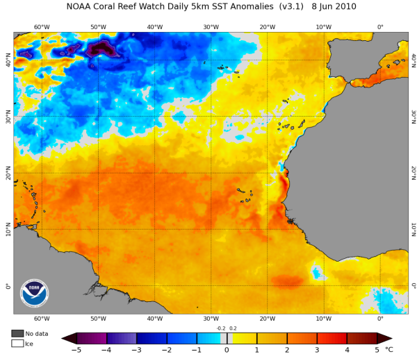
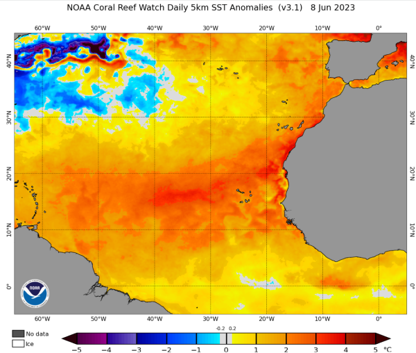
An interesting thing to note about the seasons 1899 and 1951 that are being used as analogs for this year: they both featured a major hurricane before August 20.

In fact, assuming the deep tropics/Canary Current remain warm while the subtropics remain cool, I wouldn't be surprised if this ends up alleviating some of the post-2010 early-season stability issues and allows us to see a major hurricane before bell-ringing day somewhere in the basin. This season has the potential to behave unlike many seasons a lot of us might have tracked in recent times, in other words.
6 likes   
Unless explicitly stated, all information covered in my posts is based on my opinions and observations. Please refer to a professional meteorologist or an accredited weather research agency otherwise, especially if serious decisions must be made in the event of a potentially life-threatening tropical storm or hurricane.

User avatar
SFLcane
S2K Supporter
S2K Supporter
Posts: 9606
Age: 46
Joined: Sat Jun 05, 2010 1:44 pm
Location: Lake Worth Florida

Re: 2023 Indicators (SST, SAL, MSLP, Wind shear, Steering, Instability) and Day 16+ Models

#537 Postby SFLcane » Sat Jun 10, 2023 6:30 pm

Folks look at these shear forecast! Very interesting to say the least with potential tutt even displaced further north and west. :eek: :eek:

 https://twitter.com/andyhazelton/status/1667650300985982982


1 likes   

User avatar
SFLcane
S2K Supporter
S2K Supporter
Posts: 9606
Age: 46
Joined: Sat Jun 05, 2010 1:44 pm
Location: Lake Worth Florida

Re: 2023 Indicators (SST, SAL, MSLP, Wind shear, Steering, Instability) and Day 16+ Models

#538 Postby SFLcane » Sat Jun 10, 2023 6:38 pm

You know what those shear forecast from the Ukmet and Ecmwf deserve….

:crazyeyes: :crazyeyes:
0 likes   

User avatar
cycloneye
Admin
Admin
Posts: 139025
Age: 67
Joined: Thu Oct 10, 2002 10:54 am
Location: San Juan, Puerto Rico

Re: 2023 Indicators (SST, SAL, MSLP, Wind shear, Steering, Instability) and Day 16+ Models

#539 Postby cycloneye » Sat Jun 10, 2023 7:02 pm

0 likes   
Visit the Caribbean-Central America Weather Thread where you can find at first post web cams,radars
and observations from Caribbean basin members Click Here

User avatar
Blown Away
S2K Supporter
S2K Supporter
Posts: 9861
Joined: Wed May 26, 2004 6:17 am

Re: 2023 Indicators (SST, SAL, MSLP, Wind shear, Steering, Instability) and Day 16+ Models

#540 Postby Blown Away » Sat Jun 10, 2023 7:54 pm

:uarrow: Wouldn’t those extreme SST’s in N & E Atl lower pressures in that area and possibly displace HP farther W and possibly steer systems in W Atl farther W??
3 likes   
Hurricane Eye Experience: David 79, Irene 99, Frances 04, Jeanne 04, Wilma 05...
Hurricane Brush Experience: Andrew 92, Erin 95, Floyd 99, Matthew 16, Irma 17, Ian 22, Nicole 22…


Return to “Talkin' Tropics”

Who is online

Users browsing this forum: cainjamin, Cpv17, Hurricane2022, Teban54 and 94 guests