All those cool anomalies north of 30N would argue for high pressure being parked in that area. Unless storms curve out very quickly, they could make their way west, and just north of the MDR shear wont be as bad.
2023 Indicators (SST, SAL, MSLP, Wind shear, Steering, Instability) and Day 16+ Models
Moderator: S2k Moderators
Forum rules

The posts in this forum are NOT official forecasts and should not be used as such. They are just the opinion of the poster and may or may not be backed by sound meteorological data. They are NOT endorsed by any professional institution or STORM2K. For official information, please refer to products from the National Hurricane Center and National Weather Service.
-
ScottNAtlanta

- Category 5

- Posts: 1998
- Joined: Sat May 25, 2013 3:11 pm
- Location: Atlanta, GA
Re: 2023 Indicators (SST, SAL, MSLP, Wind shear, Steering, Instability) and Day 16+ Models
All those cool anomalies north of 30N would argue for high pressure being parked in that area. Unless storms curve out very quickly, they could make their way west, and just north of the MDR shear wont be as bad.
0 likes
The posts in this forum are NOT official forecast and should not be used as such. They are just the opinion of the poster and may or may not be backed by sound meteorological data. They are NOT endorsed by any professional institution or storm2k.org. For official information, please refer to the NHC and NWS products.
-
ScottNAtlanta
- Category 5
- Posts: 1998
- Joined: Sat May 25, 2013 3:11 pm
- Location: Atlanta, GA
Re: 2023 Indicators (SST, SAL, MSLP, Wind shear, Steering, Instability) and Day 16+ Models
Another thing I have been looking at is the cold anomalies off the California coast that jut out to south of Hawaii. That might keep the central Nino region cooler that the eastern most region. What would be the effect of a very eastward centered El Nino?
0 likes
The posts in this forum are NOT official forecast and should not be used as such. They are just the opinion of the poster and may or may not be backed by sound meteorological data. They are NOT endorsed by any professional institution or storm2k.org. For official information, please refer to the NHC and NWS products.

Re: 2023 Indicators (SST, SAL, MSLP, Wind shear, Steering, Instability) and Day 16+ Models
ScottNAtlanta wrote:Another thing I have been looking at is the cold anomalies off the California coast that jut out to south of Hawaii. That might keep the central Nino region cooler that the eastern most region. What would be the effect of a very eastward centered El Nino?
In a nutshell, eastern based El Nino is the classic form that we all think of when we coin the term with its effects. The further west the warming the more 'modoki' configuration which tends to be more favorable for other basins.
There are other nuances that matter but ENSO events can change from season to season even within a singular event.
2 likes
The above post and any post by Ntxw is NOT an official forecast and should not be used as such. It is just the opinion of the poster and may or may not be backed by sound meteorological data. It is NOT endorsed by any professional institution including Storm2k. For official information, please refer to NWS products.
Help support Storm2K!

Re: 2023 Indicators (SST, SAL, MSLP, Wind shear, Steering, Instability) and Day 16+ Models
I'm surprised 1987 is not been looked at as an analog year.
0 likes
-
Category5Kaiju

- Category 5
- Posts: 3351
- Age: 22
- Joined: Thu Dec 24, 2020 12:45 pm
- Location: Seattle
Re: 2023 Indicators (SST, SAL, MSLP, Wind shear, Steering, Instability) and Day 16+ Models
NDG wrote:I'm surprised 1987 is not been looked at as an analog year.
1987 is a bad analog because the year already started off with moderate El Nino conditions (a continuation of the prior year, 1986, when the Nino first developed). The Atlantic was also much colder than it is now, and Africa was much drier.
1 likes
Unless explicitly stated, all information covered in my posts is based on my opinions and observations. Please refer to a professional meteorologist or an accredited weather research agency otherwise, especially if serious decisions must be made in the event of a potentially life-threatening tropical storm or hurricane.
-
JetFuel_SE

- Category 1

- Posts: 262
- Age: 24
- Joined: Thu Apr 30, 2020 3:57 pm
Re: 2023 Indicators (SST, SAL, MSLP, Wind shear, Steering, Instability) and Day 16+ Models
NDG wrote:I'm surprised 1987 is not been looked at as an analog year.
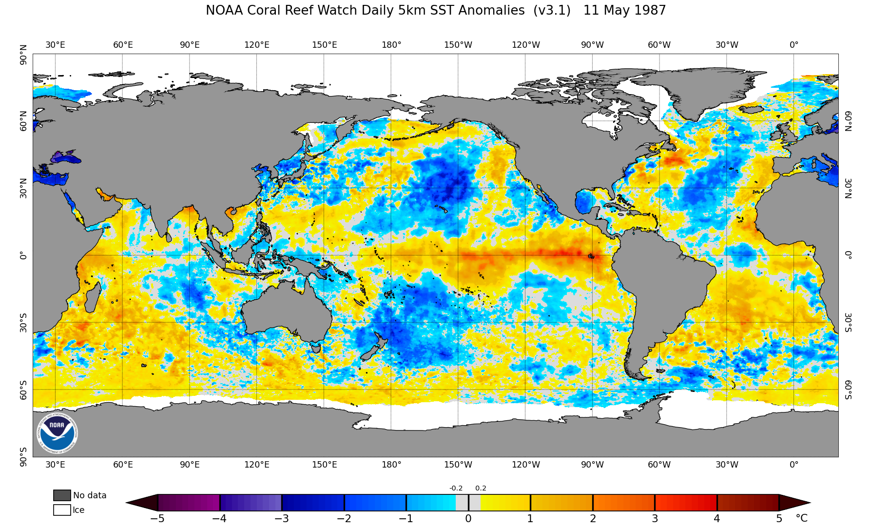

I'm not. That was a 2nd-year El Niño, this year isn't.
2 likes
-
DorkyMcDorkface

- Category 2

- Posts: 692
- Age: 26
- Joined: Mon Sep 30, 2019 1:32 pm
- Location: Mid-Atlantic
Re: 2023 Indicators (SST, SAL, MSLP, Wind shear, Steering, Instability) and Day 16+ Models
https://twitter.com/dmorris9661/status/1656616417687379972
https://twitter.com/dmorris9661/status/1656616419142823938
https://twitter.com/dmorris9661/status/1656616420539596800
https://twitter.com/dmorris9661/status/1656616419142823938
https://twitter.com/dmorris9661/status/1656616420539596800
0 likes
Floyd 1999 | Isabel 2003 | Hanna 2008 | Irene 2011 | Sandy 2012 | Isaias 2020

Re: 2023 Indicators (SST, SAL, MSLP, Wind shear, Steering, Instability) and Day 16+ Models
How did it show a drier tropical EPAC in 2023 than 2020?
0 likes
-
NotSparta

- Professional-Met

- Posts: 1645
- Age: 22
- Joined: Fri Aug 18, 2017 8:24 am
- Location: Naples, FL
- Contact:
Re: 2023 Indicators (SST, SAL, MSLP, Wind shear, Steering, Instability) and Day 16+ Models
Teban54 wrote:
How did it show a drier tropical EPAC in 2023 than 2020?
Big -PMM from the El Nino means the big precip anomalies are focused near the equator rather than further north like in 2020. It looks wetter than 2020 just in a different spot
1 likes
This post was probably an opinion of mine, and in no way is official. Please refer to http://www.hurricanes.gov for official tropical analysis and advisories.
My website, with lots of tropical wx graphics, including satellite and recon: http://cyclonicwx.com
My website, with lots of tropical wx graphics, including satellite and recon: http://cyclonicwx.com
-
cycloneye

- Admin

- Posts: 139027
- Age: 67
- Joined: Thu Oct 10, 2002 10:54 am
- Location: San Juan, Puerto Rico
Re: 2023 Indicators (SST, SAL, MSLP, Wind shear, Steering, Instability) and Day 16+ Models
weeniepatrol wrote:DorkyMcDorkface wrote:
Still think the Niño will ultimately win out in the end but there is a decent chance that the basin could still put up respectable numbers (or at least more respectable than what we typically see during these events). I've said this before but the eastern and central MDR have the potential to be relatively hospitable if TWs can get going early on (especially if aided by well-timed CCKW/MJO passage). 55W and beyond should be where storms will start encountering problems with shear the further W they track, and the Caribbean should be off-limits as is typical with El Niños, but I guess that goes without saying.
Agree completely, if this nino were going super we could probably expect a standing wave over the Epac that just nukes the Atlantic but with a lesser amplitude and this prolific Atlantic warmth, intraseasonal forcing should be able to make its way through providing windows of development. 3-4 majors is definitely possible. NOAA forecast should be soon.
The official date that they will release is going to be on May 25th.
1 likes
Visit the Caribbean-Central America Weather Thread where you can find at first post web cams,radars
and observations from Caribbean basin members Click Here
and observations from Caribbean basin members Click Here
-
SFLcane

- S2K Supporter

- Posts: 9606
- Age: 46
- Joined: Sat Jun 05, 2010 1:44 pm
- Location: Lake Worth Florida
Re: 2023 Indicators (SST, SAL, MSLP, Wind shear, Steering, Instability) and Day 16+ Models
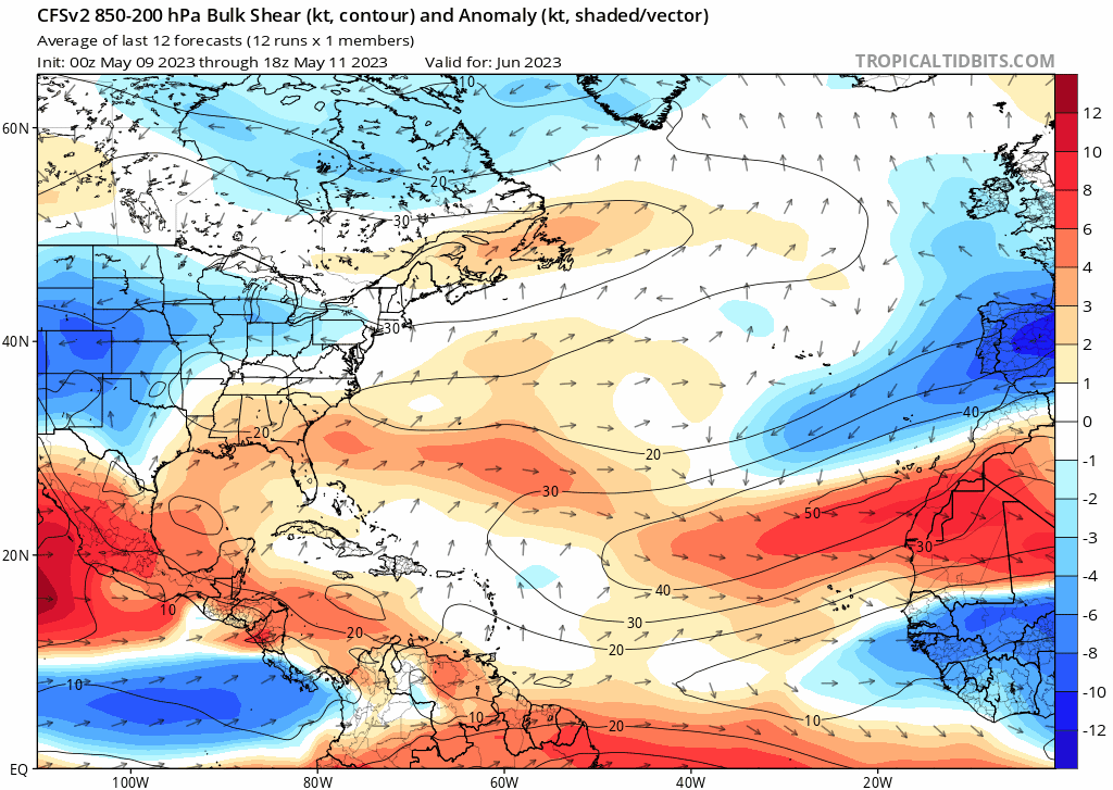
There will be a window for development across the tropical Atlantic come August as shear lowers quite a bit.
3 likes
Re: 2023 Indicators (SST, SAL, MSLP, Wind shear, Steering, Instability) and Day 16+ Models
SFLcane wrote:There will be a window for development across the tropical Atlantic come August as shear lowers quite a bit.
https://i.postimg.cc/yN9CpRVM/cfs.gif
Thanks for posting. Do you or does anyone else know how accurate the CFSv2 is regarding predicting shear anomalies 3 months out? Based on my recall, models in general often have major trouble predicting shear just a few days out, much less 3 months.
0 likes
Personal Forecast Disclaimer:
The posts in this forum are NOT official forecasts and should not be used as such. They are just the opinion of the poster and may or may not be backed by sound meteorological data. They are NOT endorsed by any professional institution or storm2k.org. For official information, please refer to the NHC and NWS products.
The posts in this forum are NOT official forecasts and should not be used as such. They are just the opinion of the poster and may or may not be backed by sound meteorological data. They are NOT endorsed by any professional institution or storm2k.org. For official information, please refer to the NHC and NWS products.
-
SFLcane
- S2K Supporter
- Posts: 9606
- Age: 46
- Joined: Sat Jun 05, 2010 1:44 pm
- Location: Lake Worth Florida
Re: 2023 Indicators (SST, SAL, MSLP, Wind shear, Steering, Instability) and Day 16+ Models
LarryWx wrote:SFLcane wrote:There will be a window for development across the tropical Atlantic come August as shear lowers quite a bit.
https://i.postimg.cc/yN9CpRVM/cfs.gif
Thanks for posting. Do you or does anyone else know how accurate the CFSv2 is regarding predicting shear anomalies 3 months out? Based on my recall, models in general often have major trouble predicting shear just a few days out, much less 3 months.
Not particularly beyond 1-2 months but i found it interesting.
1 likes
Re: 2023 Indicators (SST, SAL, MSLP, Wind shear, Steering, Instability) and Day 16+ Models
Category5Kaiju wrote:NDG wrote:I'm surprised 1987 is not been looked at as an analog year.
1987 is a bad analog because the year already started off with moderate El Nino conditions (a continuation of the prior year, 1986, when the Nino first developed). The Atlantic was also much colder than it is now, and Africa was much drier.
I do see some similarities in that during the beginning of the hurricane season SSTs between Baja MX and Hawaii along and just south of the 20th latitude were below average similar to this year with the EPAC season not really getting started until late July because of that, and the Atlantic MDR was near average to above average with a +AMO.
Despite a moderate El Nino the Atlantic's only MH was in the Caribbean and not in the subtropical Atlantic, which is the point I am trying to make that I do think this season if current Atlantic conditions continue it can easily out perform 1987 which was still during the less active Atlantic period.
5 likes
-
Category5Kaiju
- Category 5
- Posts: 3351
- Age: 22
- Joined: Thu Dec 24, 2020 12:45 pm
- Location: Seattle
Re: 2023 Indicators (SST, SAL, MSLP, Wind shear, Steering, Instability) and Day 16+ Models

So, about those MDR westerlies....

4 likes
Unless explicitly stated, all information covered in my posts is based on my opinions and observations. Please refer to a professional meteorologist or an accredited weather research agency otherwise, especially if serious decisions must be made in the event of a potentially life-threatening tropical storm or hurricane.
-
Iceresistance

- Category 5
- Posts: 8911
- Age: 20
- Joined: Sat Oct 10, 2020 9:45 am
- Location: Tecumseh, OK/Norman, OK
Re: 2023 Indicators (SST, SAL, MSLP, Wind shear, Steering, Instability) and Day 16+ Models
0 likes
Bill 2015 & Beta 2020
Winter 2020-2021
All observations are in Tecumseh, OK unless otherwise noted.
Winter posts are focused mainly for Oklahoma & Texas.
Take any of my forecasts with a grain of salt, refer to the NWS, SPC, and NHC for official information
Never say Never with weather! Because ANYTHING is possible!
Winter 2020-2021
All observations are in Tecumseh, OK unless otherwise noted.
Winter posts are focused mainly for Oklahoma & Texas.
Take any of my forecasts with a grain of salt, refer to the NWS, SPC, and NHC for official information
Never say Never with weather! Because ANYTHING is possible!
-
cycloneye
- Admin
- Posts: 139027
- Age: 67
- Joined: Thu Oct 10, 2002 10:54 am
- Location: San Juan, Puerto Rico
Re: 2023 Indicators (SST, SAL, MSLP, Wind shear, Steering, Instability) and Day 16+ Models
JB with a long thread.The Mexican cooling part is interesting.
https://twitter.com/BigJoeBastardi/status/1658473083295113220
https://twitter.com/BigJoeBastardi/status/1658473903801634818
https://twitter.com/BigJoeBastardi/status/1658474363732234245
https://twitter.com/BigJoeBastardi/status/1658474990277365762
https://twitter.com/BigJoeBastardi/status/1658475360714113025
https://twitter.com/BigJoeBastardi/status/1658475738042089472
1 likes
Visit the Caribbean-Central America Weather Thread where you can find at first post web cams,radars
and observations from Caribbean basin members Click Here
and observations from Caribbean basin members Click Here