2023 Indicators (SST, SAL, MSLP, Wind shear, Steering, Instability) and Day 16+ Models
Moderator: S2k Moderators
Forum rules
The posts in this forum are NOT official forecasts and should not be used as such. They are just the opinion of the poster and may or may not be backed by sound meteorological data. They are NOT endorsed by any professional institution or STORM2K. For official information, please refer to products from the National Hurricane Center and National Weather Service.
- weeniepatrol
- Category 3
- Posts: 857
- Joined: Sat Aug 22, 2020 5:30 pm
- Location: WA State
Re: 2023 Indicators (SST, SAL, MSLP, Wind shear, Steering, Instability) and Day 16+ Models
h/t alex boreham
I know it's not what anyone wants to hear but MDR is about to become the warmest in history.
5 likes
- galaxy401
- Category 5
- Posts: 2299
- Age: 28
- Joined: Sat Aug 25, 2012 9:04 pm
- Location: Casa Grande, Arizona
Re: 2023 Indicators (SST, SAL, MSLP, Wind shear, Steering, Instability) and Day 16+ Models
ScottNAtlanta wrote:Doesn't SAL usually peak in July when the wave train really gets going?
SAL outbreaks tend to peak from June until August. There can be strong outbreaks even in mid August.
1 likes
Got my eyes on moving right into Hurricane Alley: Florida.
- Iceresistance
- Category 5
- Posts: 8911
- Age: 20
- Joined: Sat Oct 10, 2020 9:45 am
- Location: Tecumseh, OK/Norman, OK
Re: 2023 Indicators (SST, SAL, MSLP, Wind shear, Steering, Instability) and Day 16+ Models
weeniepatrol wrote:h/t alex boreham
I know it's not what anyone wants to hear but MDR is about to become the warmest in history.
https://i.imgur.com/cYU0WXA.jpg
https://i.imgur.com/xTGLZgE.jpg
https://i.imgur.com/19idGpB.jpg
The Caribbean is crazy warm too.
0 likes
Bill 2015 & Beta 2020
Winter 2020-2021
All observations are in Tecumseh, OK unless otherwise noted.
Winter posts are focused mainly for Oklahoma & Texas.
Take any of my forecasts with a grain of salt, refer to the NWS, SPC, and NHC for official information
Never say Never with weather! Because ANYTHING is possible!
Winter 2020-2021
All observations are in Tecumseh, OK unless otherwise noted.
Winter posts are focused mainly for Oklahoma & Texas.
Take any of my forecasts with a grain of salt, refer to the NWS, SPC, and NHC for official information
Never say Never with weather! Because ANYTHING is possible!
-
- Tropical Depression
- Posts: 72
- Joined: Sun Nov 21, 2021 8:00 am
Re: 2023 Indicators (SST, SAL, MSLP, Wind shear, Steering, Instability) and Day 16+ Models
weeniepatrol wrote:h/t alex boreham
I know it's not what anyone wants to hear but MDR is about to become the warmest in history.
https://i.imgur.com/cYU0WXA.jpg
https://i.imgur.com/xTGLZgE.jpg
https://i.imgur.com/19idGpB.jpg
we're so much warmer than 2017 it's kinda funny to see. We are also so much warmer in the eastern atlantic than both 2005, 2010 but to give credit, they both had cooler subtropics than this year. Still this is truly insane how much warmer we are.
0 likes
- cycloneye
- Admin
- Posts: 139059
- Age: 67
- Joined: Thu Oct 10, 2002 10:54 am
- Location: San Juan, Puerto Rico
Re: 2023 Indicators (SST, SAL, MSLP, Wind shear, Steering, Instability) and Day 16+ Models
0 likes
Visit the Caribbean-Central America Weather Thread where you can find at first post web cams,radars
and observations from Caribbean basin members Click Here
- cycloneye
- Admin
- Posts: 139059
- Age: 67
- Joined: Thu Oct 10, 2002 10:54 am
- Location: San Juan, Puerto Rico
Re: 2023 Indicators (SST, SAL, MSLP, Wind shear, Steering, Instability) and Day 16+ Models
This is message I made on Twitter in spanish so here is the traduction.
https://twitter.com/CycloforumsPR/status/1666141455704793088
https://twitter.com/CycloforumsPR/status/1666141458003361794
It is impressive how the waters in the Atlantic and Pacific Oceans continue to warm up and everything seems that a situation is going to occur that has not happened much and it is a strong El Niño vs. a very hot Atlantic. Experts have been talking about this and find it intriguing.
It has not been easy for NOAA, CSU, etc. to make forecasts based on what is happening and therefore, they see average activity in the Atlantic that if it were not for those warm waters, they would be below normal with El Niño.
https://twitter.com/CycloforumsPR/status/1666141455704793088
https://twitter.com/CycloforumsPR/status/1666141458003361794
5 likes
Visit the Caribbean-Central America Weather Thread where you can find at first post web cams,radars
and observations from Caribbean basin members Click Here
- cycloneye
- Admin
- Posts: 139059
- Age: 67
- Joined: Thu Oct 10, 2002 10:54 am
- Location: San Juan, Puerto Rico
Re: 2023 Indicators (SST, SAL, MSLP, Wind shear, Steering, Instability) and Day 16+ Models
3 likes
Visit the Caribbean-Central America Weather Thread where you can find at first post web cams,radars
and observations from Caribbean basin members Click Here
- weeniepatrol
- Category 3
- Posts: 857
- Joined: Sat Aug 22, 2020 5:30 pm
- Location: WA State
Re: 2023 Indicators (SST, SAL, MSLP, Wind shear, Steering, Instability) and Day 16+ Models
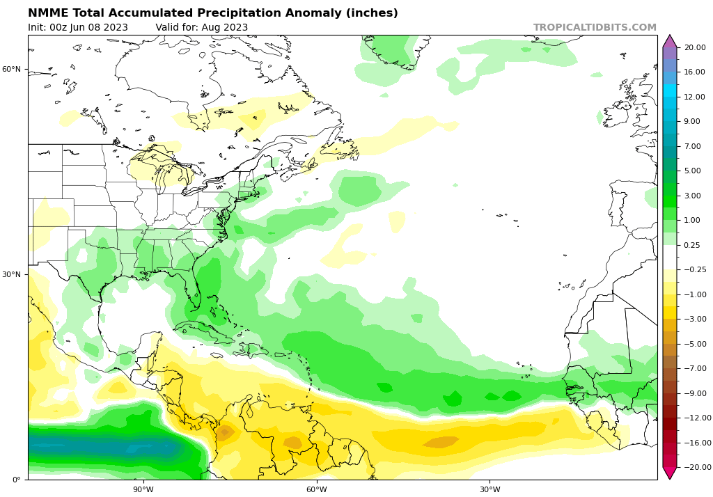
cycloneye wrote:https://twitter.com/TropicalTidbits/status/1666210099868893184
Good. Trades have been generally gentle to moderate for far too long.
2 likes
- toad strangler
- S2K Supporter
- Posts: 4162
- Joined: Sun Jul 28, 2013 3:09 pm
- Location: Earth
- Contact:
- DorkyMcDorkface
- Category 2
- Posts: 697
- Age: 26
- Joined: Mon Sep 30, 2019 1:32 pm
- Location: Mid-Atlantic
Re: 2023 Indicators (SST, SAL, MSLP, Wind shear, Steering, Instability) and Day 16+ Models
May NMME:
3 likes
Floyd 1999 | Isabel 2003 | Hanna 2008 | Irene 2011 | Sandy 2012 | Isaias 2020
- SFLcane
- S2K Supporter
- Posts: 9606
- Age: 46
- Joined: Sat Jun 05, 2010 1:44 pm
- Location: Lake Worth Florida
Re: 2023 Indicators (SST, SAL, MSLP, Wind shear, Steering, Instability) and Day 16+ Models
Watch out SFL... NMME
0 likes
- cycloneye
- Admin
- Posts: 139059
- Age: 67
- Joined: Thu Oct 10, 2002 10:54 am
- Location: San Juan, Puerto Rico
Re: 2023 Indicators (SST, SAL, MSLP, Wind shear, Steering, Instability) and Day 16+ Models
And also the NE Caribbean islands.
1 likes
Visit the Caribbean-Central America Weather Thread where you can find at first post web cams,radars
and observations from Caribbean basin members Click Here
- SFLcane
- S2K Supporter
- Posts: 9606
- Age: 46
- Joined: Sat Jun 05, 2010 1:44 pm
- Location: Lake Worth Florida
Re: 2023 Indicators (SST, SAL, MSLP, Wind shear, Steering, Instability) and Day 16+ Models
cycloneye wrote:
And also the NE Caribbean islands.
Yes sir!
0 likes
- SFLcane
- S2K Supporter
- Posts: 9606
- Age: 46
- Joined: Sat Jun 05, 2010 1:44 pm
- Location: Lake Worth Florida
Re: 2023 Indicators (SST, SAL, MSLP, Wind shear, Steering, Instability) and Day 16+ Models
Were is wxman57 i would certainly like to here his thoughts?
0 likes
Re: 2023 Indicators (SST, SAL, MSLP, Wind shear, Steering, Instability) and Day 16+ Models
Looked at the tropics for the first time in a LONG time today and GOOD GRIEF
What is peculiar to me is why the CFS, CANSIPS and clearly the NMME as well are all so conservative with the amount of shear and bullish with the precipitation anomalies despite a higher end El Nino. Is the anomalous warmth in the Atlantic enough to almost completely ward off many of the negative effects El Nino typically pushes onto the Atlantic such as shear? Generally curious if that is even possible?
What I do know is that these are uncharted waters for me (haha) and I really don't know what to think at this point.
1 likes
- DorkyMcDorkface
- Category 2
- Posts: 697
- Age: 26
- Joined: Mon Sep 30, 2019 1:32 pm
- Location: Mid-Atlantic
Re: 2023 Indicators (SST, SAL, MSLP, Wind shear, Steering, Instability) and Day 16+ Models
Apologies for the 100000th SST map post this week but I think we may have just eclipsed 2010. Like...
9 likes
Floyd 1999 | Isabel 2003 | Hanna 2008 | Irene 2011 | Sandy 2012 | Isaias 2020
- weeniepatrol
- Category 3
- Posts: 857
- Joined: Sat Aug 22, 2020 5:30 pm
- Location: WA State
-
- S2K Supporter
- Posts: 1704
- Joined: Wed Feb 26, 2003 10:53 am
- Location: Nags Head, NC
- Contact:
Re: 2023 Indicators (SST, SAL, MSLP, Wind shear, Steering, Instability) and Day 16+ Models
weeniepatrol wrote:https://i.imgur.com/2s7xInv.gif
Wow, that chart indicates that we are now at ASO sst temps.
0 likes
Re: 2023 Indicators (SST, SAL, MSLP, Wind shear, Steering, Instability) and Day 16+ Models
I'd be careful using that chart.
2 likes
- ScottNAtlanta
- Category 5
- Posts: 1998
- Joined: Sat May 25, 2013 3:11 pm
- Location: Atlanta, GA
Re: 2023 Indicators (SST, SAL, MSLP, Wind shear, Steering, Instability) and Day 16+ Models
zzzh wrote:ScottNAtlanta wrote:Doesn't SAL usually peak in July when the wave train really gets going?
SAL peaks in mid June.
From NOAA
Saharan Air Layer outbreaks usually occupy a 2 to 2.5-mile-thick layer of the atmosphere with the base starting about 1 mile above the surface. Saharan Air Layer activity usually ramps up in mid-June, peaks from late June to mid-August, and begins to rapidly subside after mid-August.
The middle point would be July, but it can peak during any of the above quoted dates.
0 likes
The posts in this forum are NOT official forecast and should not be used as such. They are just the opinion of the poster and may or may not be backed by sound meteorological data. They are NOT endorsed by any professional institution or storm2k.org. For official information, please refer to the NHC and NWS products.
Who is online
Users browsing this forum: cycloneye, duilaslol, Google Adsense [Bot], Hurricanehink, MGC, TheAustinMan, zal0phus and 120 guests