https://twitter.com/TropicalTidbits/status/1666572559259955201
2023 Indicators (SST, SAL, MSLP, Wind shear, Steering, Instability) and Day 16+ Models
Moderator: S2k Moderators
Forum rules

The posts in this forum are NOT official forecasts and should not be used as such. They are just the opinion of the poster and may or may not be backed by sound meteorological data. They are NOT endorsed by any professional institution or STORM2K. For official information, please refer to products from the National Hurricane Center and National Weather Service.
-
cycloneye

- Admin

- Posts: 139067
- Age: 67
- Joined: Thu Oct 10, 2002 10:54 am
- Location: San Juan, Puerto Rico
Re: 2023 Indicators (SST, SAL, MSLP, Wind shear, Steering, Instability) and Day 16+ Models
1 likes
Visit the Caribbean-Central America Weather Thread where you can find at first post web cams,radars
and observations from Caribbean basin members Click Here
and observations from Caribbean basin members Click Here
-
Category5Kaiju

- Category 5

- Posts: 3357
- Age: 22
- Joined: Thu Dec 24, 2020 12:45 pm
- Location: Seattle
Re: 2023 Indicators (SST, SAL, MSLP, Wind shear, Steering, Instability) and Day 16+ Models
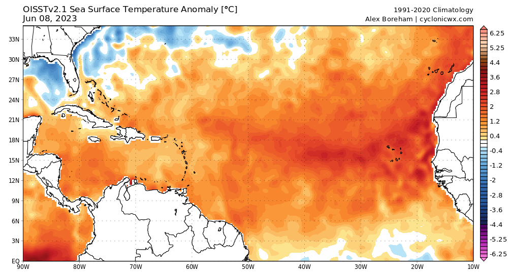
There's a pretty good chance we end up seeing the most anomalously warm tropical Atlantic at this point in time (like ever, in recorded history). Hard to believe this is happening in an El Nino year. 
1 likes
Unless explicitly stated, all information covered in my posts is based on my opinions and observations. Please refer to a professional meteorologist or an accredited weather research agency otherwise, especially if serious decisions must be made in the event of a potentially life-threatening tropical storm or hurricane.
-
wxman57

- Moderator-Pro Met

- Posts: 22480
- Age: 66
- Joined: Sat Jun 21, 2003 8:06 pm
- Location: Houston, TX (southwest)
Re: 2023 Indicators (SST, SAL, MSLP, Wind shear, Steering, Instability) and Day 16+ Models
SFLcane wrote:Were is wxman57 i would certainly like to here his thoughts?
That NMME precipitation forecast looks very close to what I'm thinking for the season. Much of the Caribbean may be dry, but I think there's an elevated risk of storms clipping the NE Caribbean on their way to the Bahamas and south Florida to the Carolinas. Also, bumped my numbers up to 17/8/3, including "One" and "Arlene".
11 likes

Re: 2023 Indicators (SST, SAL, MSLP, Wind shear, Steering, Instability) and Day 16+ Models
What I look for are the trends, surely the multi model consensus is not backing down. If anything they are making their case stronger as we get closer in time.

6 likes
-
SFLcane

- S2K Supporter

- Posts: 9606
- Age: 46
- Joined: Sat Jun 05, 2010 1:44 pm
- Location: Lake Worth Florida
Re: 2023 Indicators (SST, SAL, MSLP, Wind shear, Steering, Instability) and Day 16+ Models
wxman57 wrote:SFLcane wrote:Were is wxman57 i would certainly like to here his thoughts?
That NMME precipitation forecast looks very close to what I'm thinking for the season. Much of the Caribbean may be dry, but I think there's an elevated risk of storms clipping the NE Caribbean on their way to the Bahamas and south Florida to the Carolinas.

0 likes
-
cycloneye
- Admin
- Posts: 139067
- Age: 67
- Joined: Thu Oct 10, 2002 10:54 am
- Location: San Juan, Puerto Rico
Re: 2023 Indicators (SST, SAL, MSLP, Wind shear, Steering, Instability) and Day 16+ Models
wxman57 wrote:SFLcane wrote:Were is wxman57 i would certainly like to here his thoughts?
That NMME precipitation forecast looks very close to what I'm thinking for the season. Much of the Caribbean may be dry, but I think there's an elevated risk of storms clipping the NE Caribbean on their way to the Bahamas and south Florida to the Carolinas.
Dont like those words "clipping the NE Caribbean"
2 likes
Visit the Caribbean-Central America Weather Thread where you can find at first post web cams,radars
and observations from Caribbean basin members Click Here
and observations from Caribbean basin members Click Here
Re: 2023 Indicators (SST, SAL, MSLP, Wind shear, Steering, Instability) and Day 16+ Models
The last 7 days, nothing close to the usual eastern Caribbean TUTT, and the forecast over the next couple of weeks.


2 likes
Re: 2023 Indicators (SST, SAL, MSLP, Wind shear, Steering, Instability) and Day 16+ Models
Regarding recorded 6/11-30 W Car/Gulf TC/STC geneses since 1851, 43% (23) of the 54 storms formed during the 53 El Nino years. That's notable considering that only 31% of the 172 seasons (53 of them) since 1851 were associated with El Niño.
Here are the 23 mid to late June recorded TC/STC geneses during El Nino years in either the W Caribbean or Gulf:
1865, 1880, 1887, 1888*, 1899, 1902 (2), 1904, 1913, 1923, 1929, 1939, 1957, 1958, 1965*, 1968 (2), 1972*, 1982*, 1986, 1994, 2006, 2015*
* notes super El Niño years. A whopping 5 of the 7 (71%) super El Niño years had one of these storms! I'm mentioning this because there's a chance that 2023 will reach super status.
This leaves 31 storms that formed during the same period in the same region during 119 non-El Nino seasons or only 26% of them.
In summary, there were 23 mid to late June W Car/Gulf storms during 53 El Nino seasons for a ratio of 43%, This compares to 31 from 119 non-El Nino seasons or a ratio of only 26%. That tells me that whereas we still should take the 12 GFS runs in a row with a W Car/Gulf TCG in week 2 with a grain based on its bias toward that, we should also keep in mind that this year being El Niño means it has a significantly higher chance of occurring vs if it weren't El Niño.
Last edited by LarryWx on Thu Jun 08, 2023 8:58 am, edited 2 times in total.
6 likes
Personal Forecast Disclaimer:
The posts in this forum are NOT official forecasts and should not be used as such. They are just the opinion of the poster and may or may not be backed by sound meteorological data. They are NOT endorsed by any professional institution or storm2k.org. For official information, please refer to the NHC and NWS products.
The posts in this forum are NOT official forecasts and should not be used as such. They are just the opinion of the poster and may or may not be backed by sound meteorological data. They are NOT endorsed by any professional institution or storm2k.org. For official information, please refer to the NHC and NWS products.
-
wxman57
- Moderator-Pro Met
- Posts: 22480
- Age: 66
- Joined: Sat Jun 21, 2003 8:06 pm
- Location: Houston, TX (southwest)
Re: 2023 Indicators (SST, SAL, MSLP, Wind shear, Steering, Instability) and Day 16+ Models
cycloneye wrote:wxman57 wrote:SFLcane wrote:Were is wxman57 i would certainly like to here his thoughts?
That NMME precipitation forecast looks very close to what I'm thinking for the season. Much of the Caribbean may be dry, but I think there's an elevated risk of storms clipping the NE Caribbean on their way to the Bahamas and south Florida to the Carolinas.
Dont like those words "clipping the NE Caribbean"
Yeah, you're in the clipped part, Luis.
1 likes
-
Category5Kaiju
- Category 5
- Posts: 3357
- Age: 22
- Joined: Thu Dec 24, 2020 12:45 pm
- Location: Seattle
Re: 2023 Indicators (SST, SAL, MSLP, Wind shear, Steering, Instability) and Day 16+ Models
LarryWx wrote:Regarding recorded 6/11-30 W Car/Gulf TC geneses since 1851, 43% (23) of the 54 storms formed during the 53 El Nino years. That's notable considering that only 31% of the 172 seasons (53 of them) since 1851 were associated with El Niño.
Here are the 23 mid to late June recorded TC geneses during El Nino years in either the W Caribbean or Gulf:
1865, 1880, 1887, 1888*, 1899, 1902 (2), 1904, 1913, 1923, 1929, 1939, 1957, 1958, 1965*, 1968 (2), 1972*, 1982*, 1986, 1994, 2006, 2015*
* notes super El Niño years. A whopping 5 of the 7 (71%) super El Niño years had one of these storms! I'm mentioning this because there's a chance that 2023 will reach super status.
This leaves 31 storms that formed during the same period in the same region during 119 non-El Nino seasons or only 26% of them.
In summary, there were 23 mid to late June W Car/Gulf storms during 53 El Nino seasons for a ratio of 43%, This compared to 31 from 119 non-El Nino seasons or a ratio of only 26%. That tells me that whereas we still should take the 12 GFS runs in a row with a W Car/Gulf TCG in week 2 with a grain based on its bias toward that, we should also keep in mind that this year being El Niño means it has a significantly higher chance of occurring vs if it weren't El Niño.
1957 should be bolded; that was an El Nino year with a June Category 3 (near Category 4) hurricane
1 likes
Unless explicitly stated, all information covered in my posts is based on my opinions and observations. Please refer to a professional meteorologist or an accredited weather research agency otherwise, especially if serious decisions must be made in the event of a potentially life-threatening tropical storm or hurricane.
-
crownweather

- S2K Supporter
- Posts: 576
- Age: 49
- Joined: Sat Aug 12, 2006 9:21 am
- Location: Sturbridge, Massachusetts
- Contact:
Re: 2023 Indicators (SST, SAL, MSLP, Wind shear, Steering, Instability) and Day 16+ Models
LarryWx wrote:Regarding recorded 6/11-30 W Car/Gulf TC geneses since 1851, 43% (23) of the 54 storms formed during the 53 El Nino years. That's notable considering that only 31% of the 172 seasons (53 of them) since 1851 were associated with El Niño.
Here are the 23 mid to late June recorded TC geneses during El Nino years in either the W Caribbean or Gulf:
1865, 1880, 1887, 1888*, 1899, 1902 (2), 1904, 1913, 1923, 1929, 1939, 1957, 1958, 1965*, 1968 (2), 1972*, 1982*, 1986, 1994, 2006, 2015*
* notes super El Niño years. A whopping 5 of the 7 (71%) super El Niño years had one of these storms! I'm mentioning this because there's a chance that 2023 will reach super status.
This leaves 31 storms that formed during the same period in the same region during 119 non-El Nino seasons or only 26% of them.
In summary, there were 23 mid to late June W Car/Gulf storms during 53 El Nino seasons for a ratio of 43%, This compared to 31 from 119 non-El Nino seasons or a ratio of only 26%. That tells me that whereas we still should take the 12 GFS runs in a row with a W Car/Gulf TCG in week 2 with a grain based on its bias toward that, we should also keep in mind that this year being El Niño means it has a significantly higher chance of occurring vs if it weren't El Niño.
In my seasonal forecast I posted back in late March, I went with the following analog years (which still seem very valid, based on the latest data) - 1899, 1918, 1951, 1957, 1965, 1972, 1976, 1997 & 2009. Based on the statistic of late June TC genesis in the western Caribbean/Gulf, 4 out of the 9 analog years had a late June TC, which comes out to about to a ratio of about 44%.
Also, CSU's June 1 seasonal forecast had the following analog years - 1951, 1957, 1969, 2004 and 2006. Based on the same statistics, 2 out of the 5 analog years had a late June TC, which is a 40% ratio.
Just thought it was interesting.
4 likes
Rob Lightbown
Crown Weather Services
https://crownweather.com
Crown Weather Services
https://crownweather.com
Re: 2023 Indicators (SST, SAL, MSLP, Wind shear, Steering, Instability) and Day 16+ Models
Category5Kaiju wrote:LarryWx wrote:Regarding recorded 6/11-30 W Car/Gulf TC geneses since 1851, 43% (23) of the 54 storms formed during the 53 El Nino years. That's notable considering that only 31% of the 172 seasons (53 of them) since 1851 were associated with El Niño.
Here are the 23 mid to late June recorded TC geneses during El Nino years in either the W Caribbean or Gulf:
1865, 1880, 1887, 1888*, 1899, 1902 (2), 1904, 1913, 1923, 1929, 1939, 1957, 1958, 1965*, 1968 (2), 1972*, 1982*, 1986, 1994, 2006, 2015*
* notes super El Niño years. A whopping 5 of the 7 (71%) super El Niño years had one of these storms! I'm mentioning this because there's a chance that 2023 will reach super status.
This leaves 31 storms that formed during the same period in the same region during 119 non-El Nino seasons or only 26% of them.
In summary, there were 23 mid to late June W Car/Gulf storms during 53 El Nino seasons for a ratio of 43%, This compared to 31 from 119 non-El Nino seasons or a ratio of only 26%. That tells me that whereas we still should take the 12 GFS runs in a row with a W Car/Gulf TCG in week 2 with a grain based on its bias toward that, we should also keep in mind that this year being El Niño means it has a significantly higher chance of occurring vs if it weren't El Niño.
1957 should be bolded; that was an El Nino year with a June Category 3 (near Category 4) hurricane
Duly noted about Audrey. Also, in terms of very high impact storms, there are at least two others in the list:
- Agnes of 1972: record breaking flooding in US mid Atlantic states
- Alberto of 1994: record breaking flooding in SE US
0 likes
Personal Forecast Disclaimer:
The posts in this forum are NOT official forecasts and should not be used as such. They are just the opinion of the poster and may or may not be backed by sound meteorological data. They are NOT endorsed by any professional institution or storm2k.org. For official information, please refer to the NHC and NWS products.
The posts in this forum are NOT official forecasts and should not be used as such. They are just the opinion of the poster and may or may not be backed by sound meteorological data. They are NOT endorsed by any professional institution or storm2k.org. For official information, please refer to the NHC and NWS products.
Re: 2023 Indicators (SST, SAL, MSLP, Wind shear, Steering, Instability) and Day 16+ Models
NDG wrote:What I look for are the trends, surely the multi model consensus is not backing down. If anything they are making their case stronger as we get closer in time.
https://i.imgur.com/GphGvqO.gif
I checked at Miami the 6 wettest El Niño Julys, Augusts, and Septembers on record to see how much rain was from a nearby TC:
July:
1929: 9"/no nearby TC
1939: 14" (3rd wettest on record)/no nearby TC
1941: 15" (wettest on record)/no nearby TC
1957: 10"/no nearby TC
2002: 13" (5th wettest on record)/no nearby TC
2014: 10"/no heavy from nearby TS Arthur
August:
1905: 13"/no nearby TC
1939: 11"/no heavy from nearby H #2
1957: 17" (3rd wettest on record)/no nearby TC
1994: 17" (2nd wettest on record)/no nearby TC
2004: 10"/no heavy from nearby H Charley
2006: 13"/no heavy from nearby Chris remnants or TS Ernesto
September:
1929: 17"/very heavy from MH #2
1940: 18"/no nearby TC
1953: 13"/no nearby TC
1979: 13"/~4.5" from David/Frederic
1994: 14"/no nearby TC
2006: 17"/no nearby TC
------------------
Summary for these 18 very wet El Niño year Julys, Augusts, and Septembers:
- Only 2 of the 18 (Septs of 1929 and 1979) actually had heavy rain from a nearby TC interestingly enough
- Only 1 of the 6 Julys had nearby TC (Arthur)
- But 3 of the 6 Augusts had nearby TC, including 2 in 2006
- But 2 of the 6 Augusts had nearby hurricane
- But 2 of the 6 Septembers had 1-2 nearby hurricanes
1 likes
Personal Forecast Disclaimer:
The posts in this forum are NOT official forecasts and should not be used as such. They are just the opinion of the poster and may or may not be backed by sound meteorological data. They are NOT endorsed by any professional institution or storm2k.org. For official information, please refer to the NHC and NWS products.
The posts in this forum are NOT official forecasts and should not be used as such. They are just the opinion of the poster and may or may not be backed by sound meteorological data. They are NOT endorsed by any professional institution or storm2k.org. For official information, please refer to the NHC and NWS products.
-
InfernoFlameCat

- Category 5
- Posts: 1966
- Age: 21
- Joined: Mon Dec 14, 2020 10:52 am
- Location: Buford, GA
Re: 2023 Indicators (SST, SAL, MSLP, Wind shear, Steering, Instability) and Day 16+ Models
Does El Niño enhance winters for the southeast? What implications does it have on winter weather?
0 likes
I am by no means a professional. DO NOT look at my forecasts for official information or make decisions based on what I post.
Goal: to become a registered expert over tropical and subtropical cyclones.
Goal: to become a registered expert over tropical and subtropical cyclones.
-
SFLcane
- S2K Supporter
- Posts: 9606
- Age: 46
- Joined: Sat Jun 05, 2010 1:44 pm
- Location: Lake Worth Florida
Re: 2023 Indicators (SST, SAL, MSLP, Wind shear, Steering, Instability) and Day 16+ Models
InfernoFlameCat wrote:Does El Niño enhance winters for the southeast? What implications does it have on winter weather?
Sure, it has a magnitude of implications for the wx across the Southeast.
https://www.weather.gov/tae/enso
1 likes
-
cycloneye
- Admin
- Posts: 139067
- Age: 67
- Joined: Thu Oct 10, 2002 10:54 am
- Location: San Juan, Puerto Rico
Re: 2023 Indicators (SST, SAL, MSLP, Wind shear, Steering, Instability) and Day 16+ Models
5 likes
Visit the Caribbean-Central America Weather Thread where you can find at first post web cams,radars
and observations from Caribbean basin members Click Here
and observations from Caribbean basin members Click Here

-
cycloneye
- Admin
- Posts: 139067
- Age: 67
- Joined: Thu Oct 10, 2002 10:54 am
- Location: San Juan, Puerto Rico
Re: 2023 Indicators (SST, SAL, MSLP, Wind shear, Steering, Instability) and Day 16+ Models
0 likes
Visit the Caribbean-Central America Weather Thread where you can find at first post web cams,radars
and observations from Caribbean basin members Click Here
and observations from Caribbean basin members Click Here
-
weeniepatrol

- Category 3

- Posts: 857
- Joined: Sat Aug 22, 2020 5:30 pm
- Location: WA State
-
weeniepatrol
- Category 3
- Posts: 857
- Joined: Sat Aug 22, 2020 5:30 pm
- Location: WA State
Who is online
Users browsing this forum: chaser1, Old-TimeCane and 194 guests