2023 Global Model Runs Discussion (Out thru day 16)
Moderator: S2k Moderators
Forum rules

The posts in this forum are NOT official forecasts and should not be used as such. They are just the opinion of the poster and may or may not be backed by sound meteorological data. They are NOT endorsed by any professional institution or STORM2K. For official information, please refer to products from the National Hurricane Center and National Weather Service.
-
SFLcane

- S2K Supporter

- Posts: 9616
- Age: 46
- Joined: Sat Jun 05, 2010 1:44 pm
- Location: Lake Worth Florida
Re: 2023 Global Model Runs Discussion (Out thru day 16)
Gefs/Gfs still quite active… is it bias/phantom who knows but we will find out soon.
0 likes
-
SFLcane
- S2K Supporter
- Posts: 9616
- Age: 46
- Joined: Sat Jun 05, 2010 1:44 pm
- Location: Lake Worth Florida
Re: 2023 Global Model Runs Discussion (Out thru day 16)
SFLcane wrote:Gefs/Gfs still quite active… is it bias/phantom who knows but we will find out soon.
https://i.postimg.cc/fRtZprHP/IMG-7785.gif
It’s certainly not alone.
0 likes
-
Category5Kaiju

- Category 5

- Posts: 3379
- Age: 22
- Joined: Thu Dec 24, 2020 12:45 pm
- Location: Seattle
Re: 2023 Global Model Runs Discussion (Out thru day 16)
SFLcane wrote:Gefs/Gfs still quite active… is it bias/phantom who knows but we will find out soon.
https://i.postimg.cc/fRtZprHP/IMG-7785.gif
Still too early to tell at this point, but what I can say is that this system seems to develop in the ECAR as a silent wave rather than the typical WCAR spurious vorticity. At least that is a known method of TG, especially late in the year.
0 likes
Unless explicitly stated, all information covered in my posts is based on my opinions and observations. Please refer to a professional meteorologist or an accredited weather research agency otherwise, especially if serious decisions must be made in the event of a potentially life-threatening tropical storm or hurricane.
-
Blown Away

- S2K Supporter
- Posts: 9864
- Joined: Wed May 26, 2004 6:17 am
Re: 2023 Global Model Runs Discussion (Out thru day 16)
 best free image hosting
GFS continues to show something stirring up in the Caribbean. 06z run a good test for your weather station SFLcane!
0 likes
Hurricane Eye Experience: David 79, Irene 99, Frances 04, Jeanne 04, Wilma 05...
Hurricane Brush Experience: Andrew 92, Erin 95, Floyd 99, Matthew 16, Irma 17, Ian 22, Nicole 22…
Hurricane Brush Experience: Andrew 92, Erin 95, Floyd 99, Matthew 16, Irma 17, Ian 22, Nicole 22…
-
SFLcane
- S2K Supporter
- Posts: 9616
- Age: 46
- Joined: Sat Jun 05, 2010 1:44 pm
- Location: Lake Worth Florida
Re: 2023 Global Model Runs Discussion (Out thru day 16)
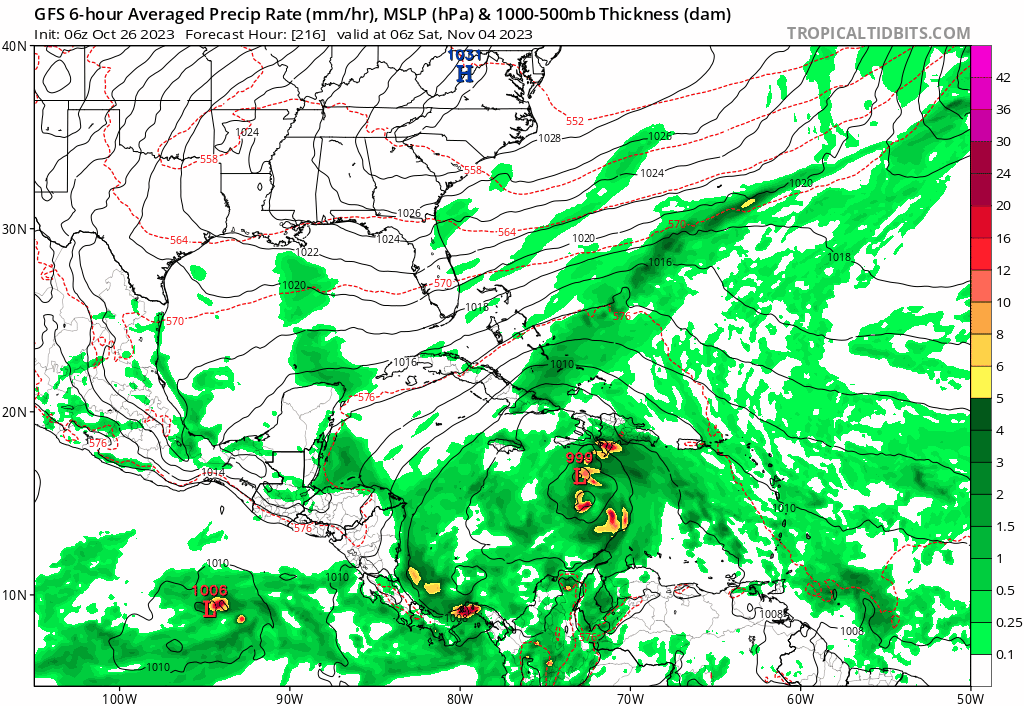
Blown Away wrote:[url]https://i.postimg.cc/X70dwkw8/gfs-mslp-pcpn-watl-fh198-384.gif [/url]best free image hosting
GFS continues to show something stirring up in the Caribbean. 06z run a good test for your weather station SFLcane!
Bring it!
0 likes
-
cycloneye

- Admin

- Posts: 139214
- Age: 67
- Joined: Thu Oct 10, 2002 10:54 am
- Location: San Juan, Puerto Rico
Re: 2023 Global Model Runs Discussion (Out thru day 16)
As long the European does not have anything, GFS is an outlier. CMC has a crossover of 92E / Pilar to SW Caribbean and develops.
0 likes
Visit the Caribbean-Central America Weather Thread where you can find at first post web cams,radars
and observations from Caribbean basin members Click Here
and observations from Caribbean basin members Click Here

Re: 2023 Global Model Runs Discussion (Out thru day 16)
Its hard to tell what will develop but certainly the shear forecasts continue to be quite favorable for the next 30 days. I would imagine something is going to form.

1 likes
The following post is NOT an official forecast and should not be used as such. It is just the opinion of the poster and may or may not be backed by sound meteorological data. It is NOT endorsed by any professional institution including storm2k.org For Official Information please refer to the NHC and NWS products.
-
chris_fit

- Category 5
- Posts: 3078
- Joined: Wed Sep 10, 2003 11:58 pm
- Location: Tampa Bay Area, FL
- Contact:
Re: 2023 Global Model Runs Discussion (Out thru day 16)
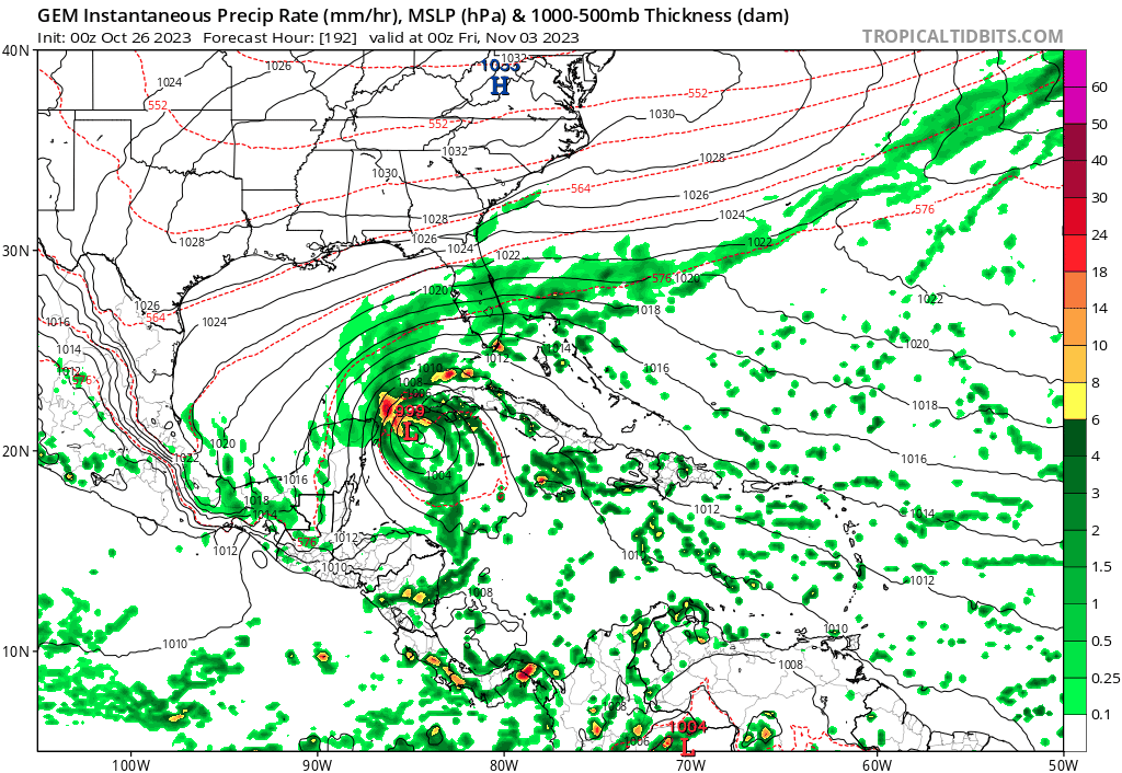
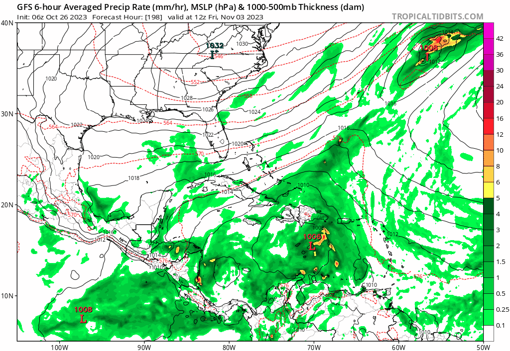
EURO, GFS, and CMC ensembles for Sat Nov 4th (Not this, but next Saturday)
TLDR; Something is gonna try to brew down there.


TLDR; Something is gonna try to brew down there.
0 likes
-
Weathertracker96
- Tropical Low

- Posts: 23
- Joined: Mon Oct 16, 2023 3:41 pm
Re: 2023 Global Model Runs Discussion (Out thru day 16)
chris_fit wrote:EURO, GFS, and CMC ensembles for Sat Nov 4th (Not this, but next Saturday)
TLDR; Something is gonna try to brew down there.
https://i.imgur.com/3yXOUhr.png
https://i.imgur.com/xBEVrd4.png
https://i.imgur.com/eWNrcGP.png
Do you think we might a code yellow sometime soon for that area or would the NHC wait to see if signals still show in a couple of days?
Unrelated to my question, it seems ensemble wise, major models are trying to show something.
0 likes
-
chris_fit
- Category 5
- Posts: 3078
- Joined: Wed Sep 10, 2003 11:58 pm
- Location: Tampa Bay Area, FL
- Contact:
Re: 2023 Global Model Runs Discussion (Out thru day 16)
Weathertracker96 wrote:chris_fit wrote:EURO, GFS, and CMC ensembles for Sat Nov 4th (Not this, but next Saturday)
TLDR; Something is gonna try to brew down there.
https://i.imgur.com/3yXOUhr.png
https://i.imgur.com/xBEVrd4.png
https://i.imgur.com/eWNrcGP.png
Do you think we might a code yellow sometime soon for that area or would the NHC wait to see if signals still show in a couple of days?
Unrelated to my question, it seems ensemble wise, major models are trying to show something.
No lemon for another couple more days most likely.
1 likes
-
DunedinDave
- Tropical Low
- Posts: 11
- Joined: Fri Aug 25, 2023 10:31 am
Re: 2023 Global Model Runs Discussion (Out thru day 16)
There’s been no consistency with this. Seems like GFS gets these happy hour runs where it bombs it to a cat 5 and then the next run it’s nothing.
I think something likely to form down there, but strength and direction are a complete unknown right now. We should know more Monday. Like someone said, we need to at least see the Euro jump on board.
I think something likely to form down there, but strength and direction are a complete unknown right now. We should know more Monday. Like someone said, we need to at least see the Euro jump on board.
0 likes
-
ThunderForce

- Tropical Storm

- Posts: 158
- Age: 25
- Joined: Tue Sep 27, 2022 6:20 pm
- Location: Florida Panhandle
Re: 2023 Global Model Runs Discussion (Out thru day 16)
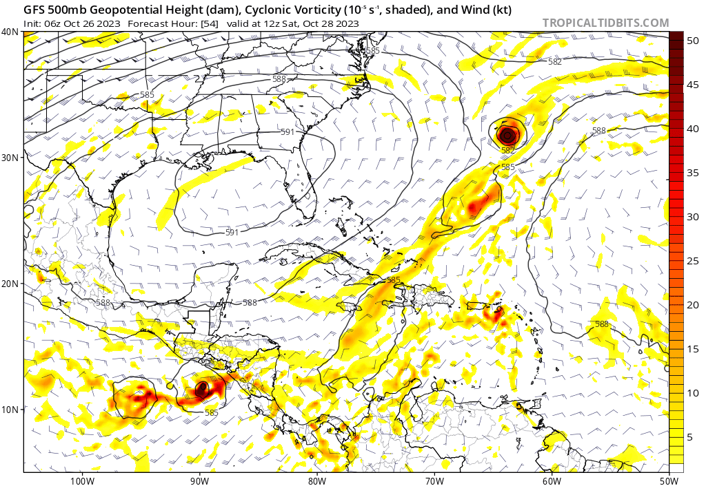
Looking at the 06 GFS run's vorticity, it seems possible that the cyclogenesis starts from some sort of vorticity in the Caribbean mixing with what may be some remnant vorticity from Tammy and/or the front that Tammy's entangled with. You can see the remnant vorticity getting pushed south at about forecast hour 174 and starting to form at the end:
0 likes
Please refer to the NWS, NHC, SPC or a professional meteorologist for information and decision making during storms.
-
SFLcane
- S2K Supporter
- Posts: 9616
- Age: 46
- Joined: Sat Jun 05, 2010 1:44 pm
- Location: Lake Worth Florida
Re: 2023 Global Model Runs Discussion (Out thru day 16)
ThunderForce wrote:Looking at the 06 GFS run's vorticity, it seems possible that the cyclogenesis starts from some sort of vorticity in the Caribbean mixing with what may be some remnant vorticity from Tammy and/or the front that Tammy's entangled with. You can see the remnant vorticity getting pushed south at about forecast hour 174 and starting to form at the end:
https://i.postimg.cc/447Fx1Vd/gfs-z500-vort-watl-fh54-222.gif
Not sure if it's Tammy or just the E Caribbean wave/slop. Either way, doesn't look all that realistic
0 likes
-
REDHurricane

- Tropical Storm
- Posts: 207
- Age: 26
- Joined: Sun Jul 03, 2022 2:36 pm
- Location: Northeast Pacific Ocean
Re: 2023 Global Model Runs Discussion (Out thru day 16)
I have an ominous feeling about this one... there is so much anomalously hot water still left in the Caribbean that logic would dictate "needs" to get transported poleward somehow, and the atmosphere looks quite conducive to TC development for this time of year as well. Obviously it's way too early to be legitimately concerned or worried about anything specific, but I really think we could be in for one more major hurricane/"big one" before this season is said and done. Plus, if we're going along with the "recent hurricane seasons have been running about 2 weeks behind climatology" theory, this would line up with the typical mid-to-late October bump in development before the season begins to wind down during November/December.

Last edited by REDHurricane on Thu Oct 26, 2023 10:29 am, edited 2 times in total.
1 likes
-
SFLcane
- S2K Supporter
- Posts: 9616
- Age: 46
- Joined: Sat Jun 05, 2010 1:44 pm
- Location: Lake Worth Florida
Re: 2023 Global Model Runs Discussion (Out thru day 16)
REDHurricane wrote:I have an ominous feeling about this one... there is so much anomalously hot water still left in the Caribbean that logic would dictate "needs" to get transported poleward somehow, and the atmosphere looks quite conducive to TC development for this time of year as well. Obviously it's way too early to be legitimately concerned or worried about anything specific, but I really think we could be in for one more major hurricane/"big one" before this season is said and done. Plus, if we're going along with the "recent hurricane seasons have been running about 2 weeks behind climatology" theory, this would line up with the common mid-to-late October bump in development before the season typically begins to wind down.
https://www.tropicaltidbits.com/analysis/ocean/cdas-sflux_sst_watl_1.png
They're always warm though...GFS produces about 100 out of every 1 TCs that happen there.
0 likes
-
AutoPenalti
- Category 5
- Posts: 3949
- Age: 27
- Joined: Mon Aug 17, 2015 4:16 pm
- Location: Ft. Lauderdale, Florida
Re: 2023 Global Model Runs Discussion (Out thru day 16)
Looks Phantom. No other model other than the CMC and GFS develops this, and seems to originate from an area known to produce vorticies up the wazoo.
Last edited by AutoPenalti on Thu Oct 26, 2023 10:49 am, edited 1 time in total.
1 likes
The posts in this forum are NOT official forecasts and should not be used as such. They are just the opinion of the poster and may or may not be backed by sound meteorological data. They are NOT endorsed by any professional institution or STORM2K. For official information, please refer to products from the NHC and NWS.
Model Runs Cheat Sheet:
GFS (5:30 AM/PM, 11:30 AM/PM)
HWRF, GFDL, UKMET, NAVGEM (6:30-8:00 AM/PM, 12:30-2:00 AM/PM)
ECMWF (1:45 AM/PM)
TCVN is a weighted averaged
-
SFLcane
- S2K Supporter
- Posts: 9616
- Age: 46
- Joined: Sat Jun 05, 2010 1:44 pm
- Location: Lake Worth Florida
Re: 2023 Global Model Runs Discussion (Out thru day 16)
AutoPenalti wrote:Looks Phantom. No other model other than the CMC and GFS develops this.
Well i think low pressure could surely develope but not a full blown cat 3 tc as the gfs has.
1 likes
-
REDHurricane
- Tropical Storm
- Posts: 207
- Age: 26
- Joined: Sun Jul 03, 2022 2:36 pm
- Location: Northeast Pacific Ocean
Re: 2023 Global Model Runs Discussion (Out thru day 16)
SFLcane wrote:REDHurricane wrote:I have an ominous feeling about this one... there is so much anomalously hot water still left in the Caribbean that logic would dictate "needs" to get transported poleward somehow, and the atmosphere looks quite conducive to TC development for this time of year as well. Obviously it's way too early to be legitimately concerned or worried about anything specific, but I really think we could be in for one more major hurricane/"big one" before this season is said and done. Plus, if we're going along with the "recent hurricane seasons have been running about 2 weeks behind climatology" theory, this would line up with the common mid-to-late October bump in development before the season typically begins to wind down.
https://www.tropicaltidbits.com/analysis/ocean/cdas-sflux_sst_watl_1.png
They're always warm though...GFS produces about 100 out of every 1 TCs that happen there.
But we're already seeing strong GFS/Canadian ensemble support in the southern Caribbean less than 10 days out, and even the EPS is showing 40-50% odds for TC development in the same spot over the next ~12 days. Like I said, nothing concrete to worry about yet, but if I lived anywhere near the Caribbean I know I would be keeping a very close eye on this potential system, as it certainly wouldn't be unprecedented for a strong Caribbean hurricane to form in late October/early November.

3 likes
-
SFLcane
- S2K Supporter
- Posts: 9616
- Age: 46
- Joined: Sat Jun 05, 2010 1:44 pm
- Location: Lake Worth Florida
Re: 2023 Global Model Runs Discussion (Out thru day 16)
REDHurricane wrote:SFLcane wrote:REDHurricane wrote:I have an ominous feeling about this one... there is so much anomalously hot water still left in the Caribbean that logic would dictate "needs" to get transported poleward somehow, and the atmosphere looks quite conducive to TC development for this time of year as well. Obviously it's way too early to be legitimately concerned or worried about anything specific, but I really think we could be in for one more major hurricane/"big one" before this season is said and done. Plus, if we're going along with the "recent hurricane seasons have been running about 2 weeks behind climatology" theory, this would line up with the common mid-to-late October bump in development before the season typically begins to wind down.
https://www.tropicaltidbits.com/analysis/ocean/cdas-sflux_sst_watl_1.png
They're always warm though...GFS produces about 100 out of every 1 TCs that happen there.
But we're already seeing strong GFS/Canadian ensemble support in the southern Caribbean less than 10 days out, and even the EPS is showing 40-50% odds for TC development in the same spot over the next ~12 days. Like I said, nothing concrete to worry about yet, but if I lived anywhere near the Caribbean I know I would be keeping a very close eye on this potential system, as it certainly wouldn't be unprecedented for a strong Caribbean hurricane to form in late October/early November.
https://charts.ecmwf.int/streaming/20231025-2020/e9/ps2png-worker-commands-74964888f5-hgff2-6fe5cac1a363ec1525f54343b6cc9fd8-QUBJAJ.png
That's over a day old at this point and honestly weeklies aren't all that useful for this one. We have the 2-week EPS
0 likes
Re: 2023 Global Model Runs Discussion (Out thru day 16)
cycloneye wrote:As long the European does not have anything, GFS is an outlier. CMC has a crossover of 92E / Pilar to SW Caribbean and develops.
agreed! but after what just happened with otis in the epac, i would keep at least one eye open........
0 likes