I think looking only at operational models may not be the best option. It is visible that EPS has been trending somewhat stronger with this possible system in the last 3 - 4 runs (waiting for the next one), while Euro barely shows any vortex in its Op. run. That's why I prefer to wait a few more days before making a direct statement about something that started to be noticed by models only 2-3 days ago. Just because models were bad at forecasting several storms this year doesn't mean they will be bad at all future storms. Even a stopped clock can still be correct twice a day (even if that stopped clock is not a good analogue for models in bad times
2023 Global Model Runs Discussion (Out thru day 16)
Moderator: S2k Moderators
Forum rules

The posts in this forum are NOT official forecasts and should not be used as such. They are just the opinion of the poster and may or may not be backed by sound meteorological data. They are NOT endorsed by any professional institution or STORM2K. For official information, please refer to products from the National Hurricane Center and National Weather Service.
-
Hurricane2022

- Category 4

- Posts: 939
- Joined: Tue Aug 23, 2022 11:38 pm
- Location: Araçatuba, Brazil
Re: 2023 Global Model Runs Discussion (Out thru day 16)
I think looking only at operational models may not be the best option. It is visible that EPS has been trending somewhat stronger with this possible system in the last 3 - 4 runs (waiting for the next one), while Euro barely shows any vortex in its Op. run. That's why I prefer to wait a few more days before making a direct statement about something that started to be noticed by models only 2-3 days ago. Just because models were bad at forecasting several storms this year doesn't mean they will be bad at all future storms. Even a stopped clock can still be correct twice a day (even if that stopped clock is not a good analogue for models in bad times
1 likes
Sorry for the bad English sometimes...!
For reliable and detailed information for any meteorological phenomenon, please consult the National Hurricane Center, Joint Typhoon Warning Center , or your local Meteo Center.
--------
Una cvm Christo, pro Christo, et in Christo. Sit nomen Domini benedictvm.
For reliable and detailed information for any meteorological phenomenon, please consult the National Hurricane Center, Joint Typhoon Warning Center , or your local Meteo Center.
--------
Una cvm Christo, pro Christo, et in Christo. Sit nomen Domini benedictvm.
-
ThunderForce

- Tropical Storm

- Posts: 158
- Age: 25
- Joined: Tue Sep 27, 2022 6:20 pm
- Location: Florida Panhandle
Re: 2023 Global Model Runs Discussion (Out thru day 16)
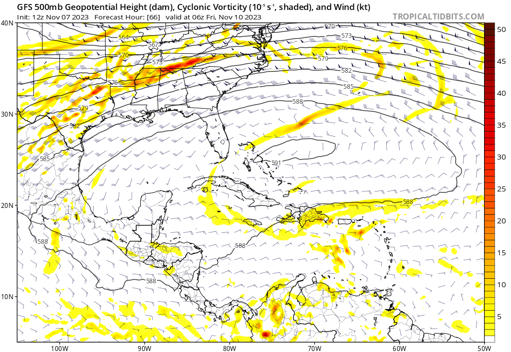
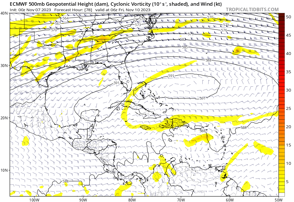
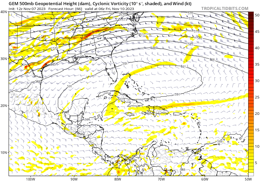
Comparing the vorticity, it seems GFS is generally developing it much faster than both Euro and CMC. Euro and CMC appear to be showing development (if any) later during their periods at the moment, with the current 12z CMC showing something trying to develop around the 16th/17th.
GFS:
Euro:
CMC/GEM:
GFS:
Euro:
CMC/GEM:
1 likes
Please refer to the NWS, NHC, SPC or a professional meteorologist for information and decision making during storms.
-
Weathertracker96
- Tropical Low

- Posts: 23
- Joined: Mon Oct 16, 2023 3:41 pm
Re: 2023 Global Model Runs Discussion (Out thru day 16)
It seems the Euro operational and even the CMC are picking up on a stronger vort down there. Remains to seen if anything will develop at all or if other models are slowly catching on
0 likes
-
jconsor
- Professional-Met

- Posts: 532
- Joined: Mon Jun 30, 2008 9:31 pm
- Location: Jerusalem, Israel
- Contact:
Re: 2023 Global Model Runs Discussion (Out thru day 16)
While climo is heavily in favor of no TC development from here on out, the pattern suggests we still need to keep a wary eye on the Caribbean next week.
https://twitter.com/yconsor/status/1721898482699739458
https://twitter.com/yconsor/status/1721900036462907643
https://twitter.com/yconsor/status/1721901333433999426
https://twitter.com/yconsor/status/1721898482699739458
https://twitter.com/yconsor/status/1721900036462907643
https://twitter.com/yconsor/status/1721901333433999426
Last edited by jconsor on Wed Nov 08, 2023 2:48 pm, edited 1 time in total.
6 likes
-
wxman57

- Moderator-Pro Met

- Posts: 22483
- Age: 66
- Joined: Sat Jun 21, 2003 8:06 pm
- Location: Houston, TX (southwest)
Re: 2023 Global Model Runs Discussion (Out thru day 16)
Euro definitely has no "hole in the ridge" to allow for any northward movement. Just more rain for Nicaragua and Honduras.
https://www.tropicaltidbits.com/analysis/models/ecmwf/2023110712/ecmwf_shear_watl_65.png
https://www.tropicaltidbits.com/analysis/models/ecmwf/2023110712/ecmwf_shear_watl_65.png
2 likes
-
Hurricane2022
- Category 4
- Posts: 939
- Joined: Tue Aug 23, 2022 11:38 pm
- Location: Araçatuba, Brazil
Re: 2023 Global Model Runs Discussion (Out thru day 16)
Hurricane2022 wrote:https://imageshack.com/i/po2d90S1p
https://imageshack.com/i/pnVk89sSp
https://imageshack.com/i/poAl7uPKp
I think looking only at operational models may not be the best option. It is visible that EPS has been trending somewhat stronger with this possible system in the last 3 - 4 runs (waiting for the next one), while Euro barely shows any vortex in its Op. run. That's why I prefer to wait a few more days before making a direct statement about something that started to be noticed by models only 2-3 days ago. Just because models were bad at forecasting several storms this year doesn't mean they will be bad at all future storms. Even a stopped clock can still be correct twice a day (even if that stopped clock is not a good analogue for models in bad times).
1 likes
Sorry for the bad English sometimes...!
For reliable and detailed information for any meteorological phenomenon, please consult the National Hurricane Center, Joint Typhoon Warning Center , or your local Meteo Center.
--------
Una cvm Christo, pro Christo, et in Christo. Sit nomen Domini benedictvm.
For reliable and detailed information for any meteorological phenomenon, please consult the National Hurricane Center, Joint Typhoon Warning Center , or your local Meteo Center.
--------
Una cvm Christo, pro Christo, et in Christo. Sit nomen Domini benedictvm.

Re: 2023 Global Model Runs Discussion (Out thru day 16)
wxman57 wrote:Euro definitely has no "hole in the ridge" to allow for any northward movement. Just more rain for Nicaragua and Honduras.
https://www.tropicaltidbits.com/analysis/models/ecmwf/2023110712/ecmwf_shear_watl_65.png
I see the TUTT digging down into the Caribbean. What ridge?
3 likes


Re: 2023 Global Model Runs Discussion (Out thru day 16)
Is this the part where people stop posting GFS runs even just for entertainment?
Anyway, the last frame of 0z Euro shows a broad area of vorticity that's getting better defined. Doesn't seem to show a ridge either, as the vorticity is moving E.
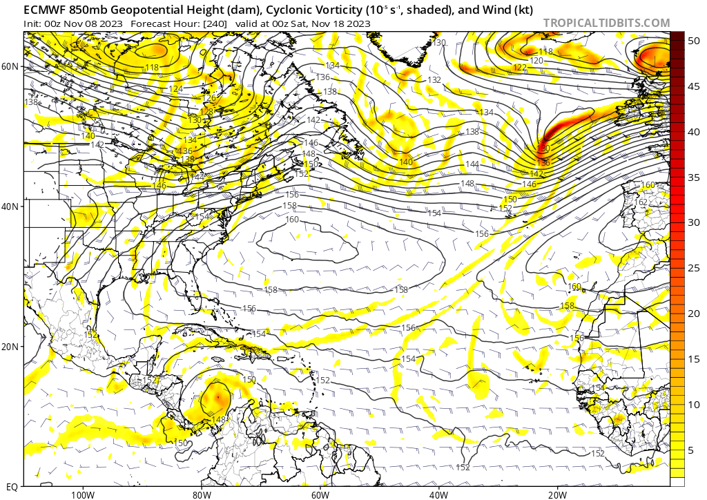
0z EPS is also getting a lot more active than last run at 240:
Anyway, the last frame of 0z Euro shows a broad area of vorticity that's getting better defined. Doesn't seem to show a ridge either, as the vorticity is moving E.
0z EPS is also getting a lot more active than last run at 240:
1 likes
-
wxman57
- Moderator-Pro Met
- Posts: 22483
- Age: 66
- Joined: Sat Jun 21, 2003 8:06 pm
- Location: Houston, TX (southwest)
Re: 2023 Global Model Runs Discussion (Out thru day 16)
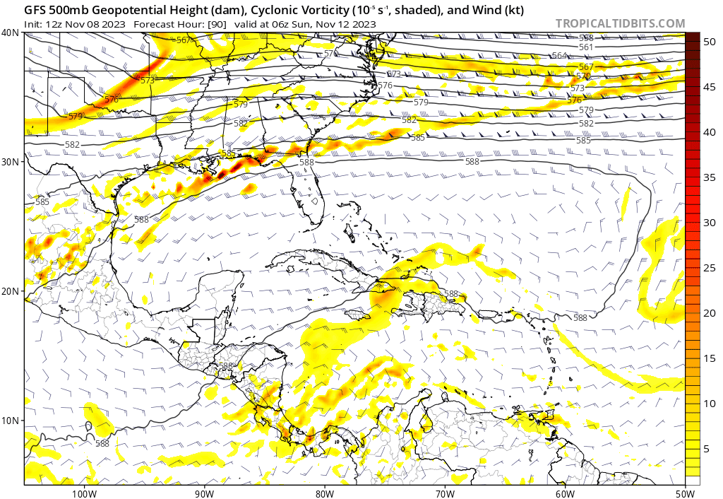
I would discard all recent GFS runs outright. While it may have a clue that a weak low will develop in the SW Caribbean, a hurricane seems VERY unlikely, given all the wind shear. EC and CMC are more believable, showing a sheared, weak low tracking eastward. Gulf is completely off limits due to strong upper-level winds that extend down to the NW Caribbean. The GFS has been doing this in every basin since it's last "upgrade". In every basin, the weakest of lows is predicted to become a major cyclone.
3 likes
-
REDHurricane

- Tropical Storm
- Posts: 207
- Age: 26
- Joined: Sun Jul 03, 2022 2:36 pm
- Location: Northeast Pacific Ocean
Re: 2023 Global Model Runs Discussion (Out thru day 16)
wxman57 wrote:I would discard all recent GFS runs outright. While it may have a clue that a weak low will develop in the SW Caribbean, a hurricane seems VERY unlikely, given all the wind shear. EC and CMC are more believable, showing a sheared, weak low tracking eastward. Gulf is completely off limits due to strong upper-level winds that extend down to the NW Caribbean. The GFS has been doing this in every basin since it's last "upgrade". In every basin, the weakest of lows is predicted to become a major cyclone.
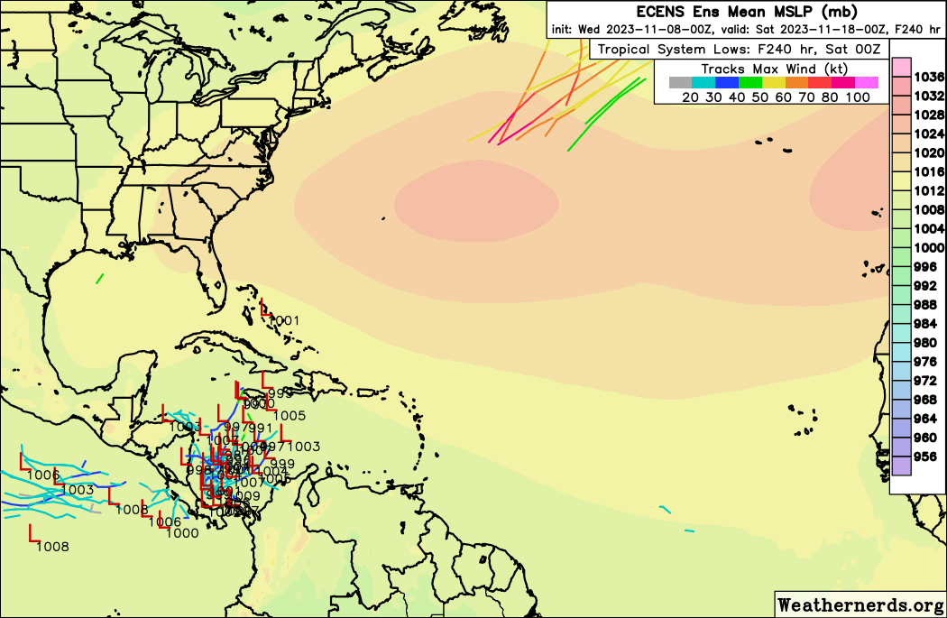
I don't know if I would completely dismiss the possibility of a hurricane just yet; both Euro and CMC ensembles have some members in in the low 990s/high 980s mb range, so based on that it wouldn't be too surprising to see a cat 1, and obviously the uncertainty remains high given that we're still 7-10 days out from anything trying to develop.
Also, wouldn't it be possible for the trough interaction to actually aid intensification if the storm happens to be located in the right spot? Again, unlikely at this point, but if a disturbance can find a sweet spot and take advantage of the 30ºC SSTs still down there in mid-November, we know very well that it's never a bad idea to expect the unexpected.


5 likes
-
ThunderForce
- Tropical Storm
- Posts: 158
- Age: 25
- Joined: Tue Sep 27, 2022 6:20 pm
- Location: Florida Panhandle
Re: 2023 Global Model Runs Discussion (Out thru day 16)
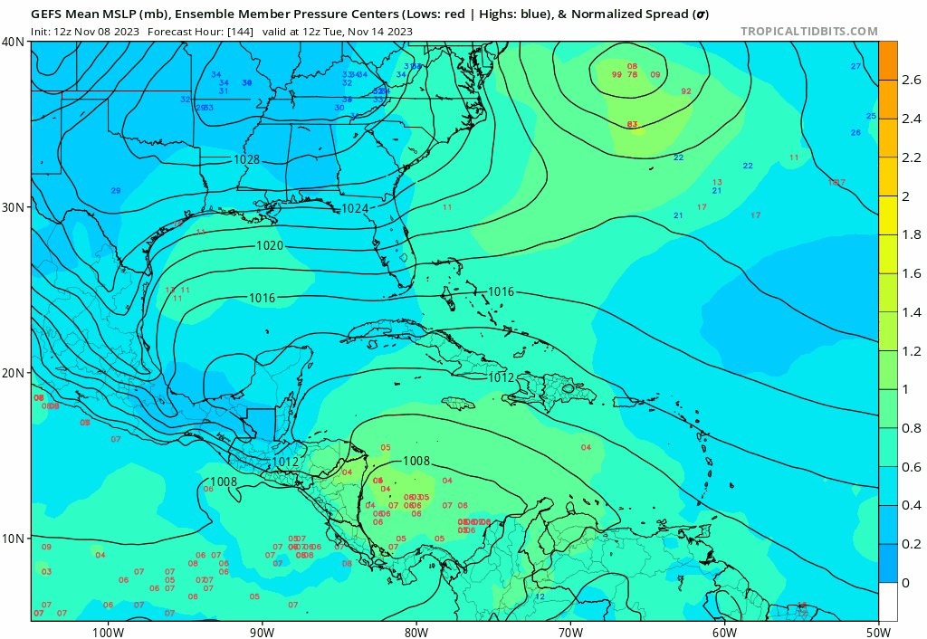
Comparing the three major models (GFS, Euro, CMC/GEM) as well as ICON, GFS appears to be strengthening the low much, much quicker than the others. 06z GFS features a 988 mb storm as soon as hour 168, with the 00z run featuring a storm with the same pressure at hour 174. 00z Euro, 00z CMC and 00z ICON on the other hand all seem to feature broad vorticity and/or weak low pressure throughout their operational runs out to hour 240.
You can even see this with the ensembles, with the GEFS lighting up like a Christmas tree at forecast hour 150 with tons of activity, while both the EPS and GEPS are showing most of the stronger and more powerful signals after hour 180.
You can even see this with the ensembles, with the GEFS lighting up like a Christmas tree at forecast hour 150 with tons of activity, while both the EPS and GEPS are showing most of the stronger and more powerful signals after hour 180.
3 likes
Please refer to the NWS, NHC, SPC or a professional meteorologist for information and decision making during storms.
-
cycloneye

- Admin

- Posts: 139234
- Age: 67
- Joined: Thu Oct 10, 2002 10:54 am
- Location: San Juan, Puerto Rico
Re: 2023 Global Model Runs Discussion (Out thru day 16)
0 likes
Visit the Caribbean-Central America Weather Thread where you can find at first post web cams,radars
and observations from Caribbean basin members Click Here
and observations from Caribbean basin members Click Here
-
floridasun
- Tropical Storm
- Posts: 107
- Joined: Tue Sep 14, 2021 3:59 pm
Re: 2023 Global Model Runs Discussion (Out thru day 16)
Don't see any thing happening any time soon their no storms in sw carribbean area yet or any storm area moving off south America into South carribbean area yet so gfs is happy hour now
0 likes
Re: 2023 Global Model Runs Discussion (Out thru day 16)
12Z UKMET: What’s this TD in the GOM?
MET OFFICE TROPICAL CYCLONE GUIDANCE FOR NORTH-EAST PACIFIC AND ATLANTIC
GLOBAL MODEL DATA TIME 1200UTC 08.11.2023
NEW TROPICAL CYCLONE FORECAST TO DEVELOP AFTER 150 HOURS
FORECAST POSITION AT T+150 : 27.9N 92.4W
LEAD CENTRAL MAXIMUM WIND
VERIFYING TIME TIME POSITION PRESSURE (MB) SPEED (KNOTS)
-------------- ---- -------- ------------- -------------
0000UTC 15.11.2023 156 28.3N 91.7W 1012 30
1200UTC 15.11.2023 168 31.1N 90.7W 1013 32
0 likes
Personal Forecast Disclaimer:
The posts in this forum are NOT official forecasts and should not be used as such. They are just the opinion of the poster and may or may not be backed by sound meteorological data. They are NOT endorsed by any professional institution or storm2k.org. For official information, please refer to the NHC and NWS products.
The posts in this forum are NOT official forecasts and should not be used as such. They are just the opinion of the poster and may or may not be backed by sound meteorological data. They are NOT endorsed by any professional institution or storm2k.org. For official information, please refer to the NHC and NWS products.
-
wxman57
- Moderator-Pro Met
- Posts: 22483
- Age: 66
- Joined: Sat Jun 21, 2003 8:06 pm
- Location: Houston, TX (southwest)
Re: 2023 Global Model Runs Discussion (Out thru day 16)
LarryWx wrote:12Z UKMET: What’s this TD in the GOM?
MET OFFICE TROPICAL CYCLONE GUIDANCE FOR NORTH-EAST PACIFIC AND ATLANTIC
GLOBAL MODEL DATA TIME 1200UTC 08.11.2023
NEW TROPICAL CYCLONE FORECAST TO DEVELOP AFTER 150 HOURS
FORECAST POSITION AT T+150 : 27.9N 92.4W
LEAD CENTRAL MAXIMUM WIND
VERIFYING TIME TIME POSITION PRESSURE (MB) SPEED (KNOTS)
-------------- ---- -------- ------------- -------------
0000UTC 15.11.2023 156 28.3N 91.7W 1012 30
1200UTC 15.11.2023 168 31.1N 90.7W 1013 32
Just a frontal wave.
1 likes
-
ThunderForce
- Tropical Storm
- Posts: 158
- Age: 25
- Joined: Tue Sep 27, 2022 6:20 pm
- Location: Florida Panhandle
Re: 2023 Global Model Runs Discussion (Out thru day 16)
Once again, the 12z GFS develops the vorticity in the south Caribbean into a hurricane.
Also, here's the 12z GEFS. Extremely active as usual.
Also, here's the 12z GEFS. Extremely active as usual.
1 likes
Please refer to the NWS, NHC, SPC or a professional meteorologist for information and decision making during storms.

Re: 2023 Global Model Runs Discussion (Out thru day 16)
I have some friends doing an Atlantic crossing from Lisbon to New York this week. Looks like they be in for a wild ride.
0 likes
-
ThunderForce
- Tropical Storm
- Posts: 158
- Age: 25
- Joined: Tue Sep 27, 2022 6:20 pm
- Location: Florida Panhandle
Re: 2023 Global Model Runs Discussion (Out thru day 16)
0 likes
Please refer to the NWS, NHC, SPC or a professional meteorologist for information and decision making during storms.
-
jconsor
- Professional-Met
- Posts: 532
- Joined: Mon Jun 30, 2008 9:31 pm
- Location: Jerusalem, Israel
- Contact:
Re: 2023 Global Model Runs Discussion (Out thru day 16)
Signal for tropical cyclone formation in the W. Caribbean by late next week (and northward movement thereafter) has grown.
https://twitter.com/yconsor/status/1722334714344661186
https://twitter.com/yconsor/status/1722342729559011650
https://twitter.com/yconsor/status/1722334714344661186
https://twitter.com/yconsor/status/1722342729559011650
2 likes
-
jlauderdal
- S2K Supporter

- Posts: 6776
- Joined: Wed May 19, 2004 5:46 am
- Location: NE Fort Lauderdale
- Contact:
Re: 2023 Global Model Runs Discussion (Out thru day 16)
Another last chance systemjconsor wrote:Signal for tropical cyclone formation in the W. Caribbean by late next week (and northward movement thereafter) has grown.
https://twitter.com/yconsor/status/1722334714344661186
https://twitter.com/yconsor/status/1722342729559011650
0 likes
Who is online
Users browsing this forum: Beef Stew, JetFuel_SE, Jr0d, skyline385, zzzh and 116 guests