2023 Global Model Runs Discussion (Out thru day 16)

This is the general tropical discussion area. Anyone can take their shot at predicting a storms path.

Moderator: S2k Moderators

Forum rules

The posts in this forum are NOT official forecasts and should not be used as such. They are just the opinion of the poster and may or may not be backed by sound meteorological data. They are NOT endorsed by any professional institution or STORM2K. For official information, please refer to products from the National Hurricane Center and National Weather Service.

Help Support Storm2K
Message
Author
User avatar
DorkyMcDorkface
Category 2
Category 2
Posts: 709
Age: 26
Joined: Mon Sep 30, 2019 1:32 pm
Location: Mid-Atlantic

Re: 2023 Global Model Runs Discussion (Out thru day 16)

#221 Postby DorkyMcDorkface » Sat Jun 10, 2023 1:05 pm

USTropics wrote:
DorkyMcDorkface wrote:This is a bit of a ways out but I am honestly more interested in this MDR signal the GEFS is latching on to; it's been there the past few runs. A tropical wave is obviously a much more realistic pathway to cyclogenesis than the spurious Venezuelan vorticity the GFS is always obsessed with this time of year. For that reason, I feel more confidence in other models possibly sniffing this out in the near future. With the current SSTs I'd say an early season MDR TD/TS is within the realm of possibility. We'll see.
https://i.ibb.co/SK0q8Yc/90668154-2.gif


The GFS actually isn't developing this from a spurious vorticity associated with the CAG, it's origins are related to a TW that is expected to depart the coast of Africa here shortly. You can follow this in the 700mb vort signature from the latest GFS run below (roughly highlighted the wave axis in pink in the animation below):

https://i.ibb.co/wd8WNhc/gifmaker-me.gif

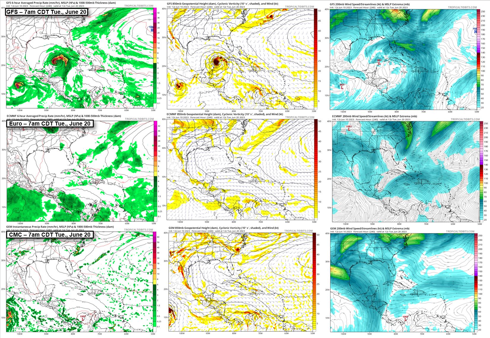
The difference in the models is the upper-level features and steering pattern. The GFS has a sharp trough that extends all the way down towards the Yucatan peninsula (highlighted in pink below). This has multiple impacts: (1) displaces the subtropical high towards the northeast (highlighted in orange), (2) erodes the western periphery of the high pressure area, (3) reduces zonal flow in the Caribbean, and (4) provides the necessary "lift" for this tropical wave to exit the Caribbean towards the GOM.

https://i.imgur.com/OdkCd1I.png

Compare this to last night's 00z ECMWF run at the same time frame, and you can see the high pressure is oriented more E to W and extends further west, there is only a weak signature of a trough over CONUS that doesnt extend nearly as far south, and the zonal flow in the Caribbean carries the wave vort signature through Central America and into the EPAC.
https://i.imgur.com/KzJfZYL.png

I stand corrected, thanks for the clarification. I suppose it is just years of false alarms from the GFS that have me skeptical. I still remain so however because it continues to be the only model showing this scenario.
1 likes   
Floyd 1999 | Isabel 2003 | Hanna 2008 | Irene 2011 | Sandy 2012 | Isaias 2020

User avatar
Europa non è lontana
Tropical Depression
Tropical Depression
Posts: 93
Joined: Wed Nov 11, 2020 10:01 pm

Re: 2023 Global Model Runs Discussion (Out thru day 16)

#222 Postby Europa non è lontana » Sat Jun 10, 2023 1:08 pm

I don't think it's unreasonable for people to be skeptical of the GFS given its history of false alarms in this exact region and that no other model as of the 12z runs has this wave developing into an Atlantic TC, as far as I know.
0 likes   

User avatar
wxman57
Moderator-Pro Met
Moderator-Pro Met
Posts: 22482
Age: 66
Joined: Sat Jun 21, 2003 8:06 pm
Location: Houston, TX (southwest)

Re: 2023 Global Model Runs Discussion (Out thru day 16)

#223 Postby wxman57 » Sat Jun 10, 2023 2:00 pm

JetFuel_SE wrote:
BobHarlem wrote:
MetroMike wrote:No one is paying attention to the Last GFS?


With the Euro and CMC both showing nada (except maybe in the EPAC), not really.

The CMC is a joke, and the Euro only has a TC forming when it's already been named for a solid 24 hours.
Let's just wait and see.


Look at the upper-level patterns in each model, not the surface. The upper-air patterns in the Euro and CMC are nothing like the GFS, which is why the GFS is developing a Caribbean storm and they are not. Euro is indicating East Pac development, which is probably right.
0 likes   

USTropics
Category 5
Category 5
Posts: 2414
Joined: Sun Aug 12, 2007 3:45 am
Location: Florida State University

Re: 2023 Global Model Runs Discussion (Out thru day 16)

#224 Postby USTropics » Sat Jun 10, 2023 3:08 pm

Europa non è lontana wrote:I don't think it's unreasonable for people to be skeptical of the GFS given its history of false alarms in this exact region and that no other model as of the 12z runs has this wave developing into an Atlantic TC, as far as I know.


Models are just tools at the end of the day, it's up to the forecaster to understand and use them properly. Past ~7 days, ensembles can given us a better understanding/picture of what type of pattern we see evolving (and where we should give more credence). One reason to remain skeptical is the run to run consistency from the ECMWF ensembles in the evolving pattern. Typically when the ECMWF ensembles are this consistent it lends to more credibility.

ECMWF ensemble trend:
Image

Meanwhile, the GFS ensembles have been a bit more fluid with its depiction and orientation of the trough from run to run:
Image

The CMC ensembles in the past few runs have also trended towards more ridging in the NW Caribbean/GOM, which lends more credence to the ECMWF ensemble solutions:
Image

The type of pattern the ECMWF and CMC ensembles show (with more ridging and a less pronounced trough) would indicate to me development would be more concentrated in the EPAC. As someone said earlier, this doesn't preclude development occurring in both basins, but it's likely the GFS is overdoing the trough in its long range forecast.
2 likes   

User avatar
cycloneye
Admin
Admin
Posts: 139151
Age: 67
Joined: Thu Oct 10, 2002 10:54 am
Location: San Juan, Puerto Rico

Re: 2023 Global Model Runs Discussion (Out thru day 16)

#225 Postby cycloneye » Sat Jun 10, 2023 3:11 pm

3 likes   
Visit the Caribbean-Central America Weather Thread where you can find at first post web cams,radars
and observations from Caribbean basin members Click Here

User avatar
wxman57
Moderator-Pro Met
Moderator-Pro Met
Posts: 22482
Age: 66
Joined: Sat Jun 21, 2003 8:06 pm
Location: Houston, TX (southwest)

Re: 2023 Global Model Runs Discussion (Out thru day 16)

#226 Postby wxman57 » Sat Jun 10, 2023 3:31 pm

GFS still has a completely different surface and upper level pattern at day 10. Euro an Canadian have a similar 850mb and 200mb pattern.

Image
2 likes   

User avatar
cycloneye
Admin
Admin
Posts: 139151
Age: 67
Joined: Thu Oct 10, 2002 10:54 am
Location: San Juan, Puerto Rico

Re: 2023 Global Model Runs Discussion (Out thru day 16)

#227 Postby cycloneye » Sat Jun 10, 2023 4:45 pm

Euro ensembles have a MDR signal.

Image
9 likes   
Visit the Caribbean-Central America Weather Thread where you can find at first post web cams,radars
and observations from Caribbean basin members Click Here

OuterBanker
S2K Supporter
S2K Supporter
Posts: 1704
Joined: Wed Feb 26, 2003 10:53 am
Location: Nags Head, NC
Contact:

Re: 2023 Global Model Runs Discussion (Out thru day 16)

#228 Postby OuterBanker » Sat Jun 10, 2023 7:35 pm

:double: :eek: :roll:

Just goes to show you that if you wait long enough the GFS will target you.

https://www.dropbox.com/s/8la2iflpz84pz ... 0.png?dl=0

Let's see, started in the Bahamas, Naples, NOLA, TX, Mx, this morning Cancun 18z today cat 3 on the OBX.

But, I have to admit that without the GFS it would be God awful boring.
4 likes   

User avatar
tiger_deF
Category 1
Category 1
Posts: 437
Age: 23
Joined: Tue Sep 27, 2016 11:47 am

Re: 2023 Global Model Runs Discussion (Out thru day 16)

#229 Postby tiger_deF » Sat Jun 10, 2023 7:41 pm

I'm still fairly sure that the storm is a phantom, but unlike most typical phantoms the timeline hasn't been pushed too far back since the storm popped up a week ago. Plus, there is some GEFS support now as well.
1 likes   

User avatar
Kingarabian
S2K Supporter
S2K Supporter
Posts: 15439
Joined: Sat Aug 08, 2009 3:06 am
Location: Honolulu, Hawaii

Re: 2023 Global Model Runs Discussion (Out thru day 16)

#230 Postby Kingarabian » Sat Jun 10, 2023 8:34 pm

Imo this early on, only way the GFS solution makes sense is IF it did not show EPAC development. So unless it drops the EPAC system, it's hard to believe.
0 likes   
RIP Kobe Bryant

User avatar
MetroMike
Category 3
Category 3
Posts: 827
Joined: Sun Aug 29, 2004 8:13 pm
Location: Tampa Bay
Contact:

Re: 2023 Global Model Runs Discussion (Out thru day 16)

#231 Postby MetroMike » Sat Jun 10, 2023 8:38 pm

Kingarabian wrote:Imo this early on, only way the GFS solution makes sense is IF it did not show EPAC development. So unless it drops the EPAC system, it's hard to believe.


The EPAC system was very weak or non exsistent on the 18Z run ICYMI.
0 likes   

User avatar
Teban54
Category 5
Category 5
Posts: 1960
Joined: Sat May 19, 2018 1:19 pm

Re: 2023 Global Model Runs Discussion (Out thru day 16)

#232 Postby Teban54 » Sun Jun 11, 2023 12:05 am

Unless I'm mistaken (which I jolly well might), the 0z GFS seems to bury the first Caribbean system into Yucatan and briefly BoC, then develop a second system, blow it up and send it towards FL.

Could be a sign towards "correcting" the trajectory of the system and more ridging.
1 likes   

LarryWx
Category 5
Category 5
Posts: 5708
Joined: Sun Sep 07, 2003 2:04 pm
Location: GA

Re: 2023 Global Model Runs Discussion (Out thru day 16)

#233 Postby LarryWx » Sun Jun 11, 2023 1:43 am

Teban54 wrote:Unless I'm mistaken (which I jolly well might), the 0z GFS seems to bury the first Caribbean system into Yucatan and briefly BoC, then develop a second system, blow it up and send it towards FL.

Could be a sign towards "correcting" the trajectory of the system and more ridging.


Although this is by my count the 23rd straight GFS run (going back to the 12Z run on June 5th) with a TC in the W Caribbean from this, it appears to me to be the first of those 23 without it getting to TS+ strength in the W Caribbean as this appears to only be a TD per soundings before moving into Belize.
3 likes   
Personal Forecast Disclaimer:
The posts in this forum are NOT official forecasts and should not be used as such. They are just the opinion of the poster and may or may not be backed by sound meteorological data. They are NOT endorsed by any professional institution or storm2k.org. For official information, please refer to the NHC and NWS products.

User avatar
AtlanticWind
S2K Supporter
S2K Supporter
Posts: 1805
Age: 65
Joined: Sun Aug 08, 2004 9:57 pm
Location: Plantation,Fla

Re: 2023 Global Model Runs Discussion (Out thru day 16)

#234 Postby AtlanticWind » Sun Jun 11, 2023 4:10 am

EURO has a disturbance heading for the Islands in latest run.
4 likes   

User avatar
Category5Kaiju
Category 5
Category 5
Posts: 3361
Age: 22
Joined: Thu Dec 24, 2020 12:45 pm
Location: Seattle

2023 Indicators (SST, SAL, MSLP, Wind shear, Steering, Instability) and Day 16+ Models

#235 Postby Category5Kaiju » Sun Jun 11, 2023 8:52 am

Guys let's stop focusing on the major Gulf hurricane that the GFS keeps blowing up; there's a new sheriff in town with support from multiple models :lol:

 https://twitter.com/OSUWXGUY/status/1667855014050627584


6 likes   
Unless explicitly stated, all information covered in my posts is based on my opinions and observations. Please refer to a professional meteorologist or an accredited weather research agency otherwise, especially if serious decisions must be made in the event of a potentially life-threatening tropical storm or hurricane.

User avatar
wxman57
Moderator-Pro Met
Moderator-Pro Met
Posts: 22482
Age: 66
Joined: Sat Jun 21, 2003 8:06 pm
Location: Houston, TX (southwest)

Re: 2023 Global Model Runs Discussion (Out thru day 16)

#236 Postby wxman57 » Sun Jun 11, 2023 8:56 am

AtlanticWind wrote:EURO has a disturbance heading for the Islands in latest run.


Tracking the 850mb vorticity backwards, it has a feature moving off the coast of Africa tomorrow. It's a bit early for development east of the islands. Shear is too high. Something like that would have to be monitored more closely as it moves to the western Caribbean in about 13 days. It would probably cross Central America and go into the East Pac.
0 likes   

LarryWx
Category 5
Category 5
Posts: 5708
Joined: Sun Sep 07, 2003 2:04 pm
Location: GA

Re: 2023 Global Model Runs Discussion (Out thru day 16)

#237 Postby LarryWx » Sun Jun 11, 2023 12:52 pm

Like the 6Z GFS, the 12Z GFS has a strong TS developing in the W Caribbean before going inland into the Yucatan. It is the 3rd one in a row moving W into the Yucatan. This now makes 25 GFS runs in a row with a W Caribbean TC that forms within a day of 6/18. Is this W Car TC for real or not? The longest streak of GFS runs in a row that I can recall that turned out to be fake was 30 something.

El Niño seasons with +1.3+ in ASO since the late 1800s have had TCs form in mid to late June in the W Caribbean or Gulf more often than not fwiw. Of course, even if that occurs this season, too, it doesn't have to be from the one the GFS has been developing. It could be from something as late as 12 days later.
1 likes   
Personal Forecast Disclaimer:
The posts in this forum are NOT official forecasts and should not be used as such. They are just the opinion of the poster and may or may not be backed by sound meteorological data. They are NOT endorsed by any professional institution or storm2k.org. For official information, please refer to the NHC and NWS products.

User avatar
Hypercane_Kyle
Category 5
Category 5
Posts: 2900
Joined: Sat Mar 07, 2015 7:58 pm
Location: Cape Canaveral, FL

Re: 2023 Global Model Runs Discussion (Out thru day 16)

#238 Postby Hypercane_Kyle » Sun Jun 11, 2023 1:06 pm

GFS ensemble support remains quite strong.
2 likes   
My posts are my own personal opinion, defer to the National Hurricane Center (NHC) and other NOAA products for decision making during hurricane season.

User avatar
wxman57
Moderator-Pro Met
Moderator-Pro Met
Posts: 22482
Age: 66
Joined: Sat Jun 21, 2003 8:06 pm
Location: Houston, TX (southwest)

Re: 2023 Global Model Runs Discussion (Out thru day 16)

#239 Postby wxman57 » Sun Jun 11, 2023 3:01 pm

Perhaps the GFS can set a new record for the most consecutive runs showing a phantom storm? I saw mentioned a few pages back that the GFS has done well in the West Pacific. Uh, no, it hasn't. We forecast cyclones worldwide and watch the model runs very closely. It is constantly developing phantom storms in every basin. If it's alone in its prediction, it is best to ignore the GFS. I think that the GFS is having trouble with the upper-air pattern beyond 5-7 days. As a result, it is generating this phantom Caribbean/Gulf storm.
1 likes   

User avatar
wxman57
Moderator-Pro Met
Moderator-Pro Met
Posts: 22482
Age: 66
Joined: Sat Jun 21, 2003 8:06 pm
Location: Houston, TX (southwest)

Re: 2023 Global Model Runs Discussion (Out thru day 16)

#240 Postby wxman57 » Sun Jun 11, 2023 7:07 pm

The GFS is like a slot machine. Each run has a different solution, but that solution is not matched by other models.
2 likes   


Return to “Talkin' Tropics”

Who is online

Users browsing this forum: AnnularCane, Blown Away, duilaslol, skyline385 and 178 guests