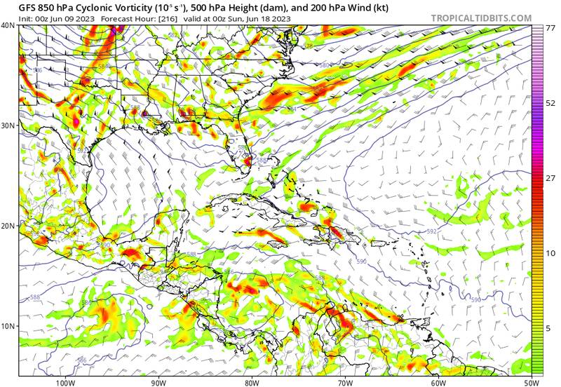
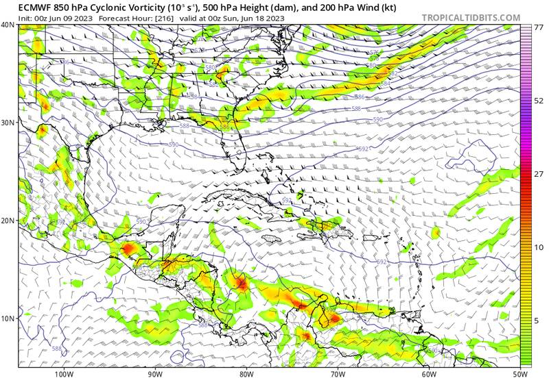
2023 Global Model Runs Discussion (Out thru day 16)

This is the general tropical discussion area. Anyone can take their shot at predicting a storms path.

Moderator: S2k Moderators

Forum rules

The posts in this forum are NOT official forecasts and should not be used as such. They are just the opinion of the poster and may or may not be backed by sound meteorological data. They are NOT endorsed by any professional institution or STORM2K. For official information, please refer to products from the National Hurricane Center and National Weather Service.

Help Support Storm2K
Message
Author
User avatar
SFLcane
S2K Supporter
S2K Supporter
Posts: 9606
Age: 46
Joined: Sat Jun 05, 2010 1:44 pm
Location: Lake Worth Florida

Re: 2023 Global Model Runs Discussion (Out thru day 16)

#181 Postby SFLcane » Thu Jun 08, 2023 11:51 am

LarryWx wrote:
cycloneye wrote:The timeframe is approaching 7 days and we will find out if NHC is interested or not.


With the 12Z today, it is up to 13 GFS runs in a row with a strong W Caribbean/GOM TC in week 2.


Only to drop it after 25 runs. You''ll see.

Crazy stubborn model
5 likes   

User avatar
cainjamin
Tropical Storm
Tropical Storm
Posts: 158
Age: 32
Joined: Mon Apr 17, 2017 1:38 pm
Location: Nova Scotia, Canada

Re: 2023 Global Model Runs Discussion (Out thru day 16)

#182 Postby cainjamin » Thu Jun 08, 2023 11:59 am

I'm not buying the GFS. It does this every single year around this time; same location, same storm, same dates. If the EC or CMC jumps on the bandwagon over the next few days I'll be a little more intrigued, but for now it feels very phantomy.
2 likes   
Noel '07, Kyle '08, Earl '10, Arthur '14, Dorian '19, Teddy '20

User avatar
MGC
S2K Supporter
S2K Supporter
Posts: 5792
Joined: Sun Mar 23, 2003 9:05 pm
Location: Pass Christian MS, or what is left.

Re: 2023 Global Model Runs Discussion (Out thru day 16)

#183 Postby MGC » Thu Jun 08, 2023 12:51 pm

May of 2022 had a similar GFS solution. I'll believe the GFS when other models get onboard......MGC
1 likes   

User avatar
NDG
S2K Supporter
S2K Supporter
Posts: 14933
Joined: Sun Jul 09, 2006 10:14 pm
Location: Orlando, FL

Re: 2023 Global Model Runs Discussion (Out thru day 16)

#184 Postby NDG » Thu Jun 08, 2023 1:11 pm

Once it gets within the 5-7 day range either the GFS will drop it or other models will join in.
It never fails.
6 likes   

User avatar
AnnularCane
S2K Supporter
S2K Supporter
Posts: 2634
Joined: Thu Jun 08, 2006 9:18 am
Location: Wytheville, VA

Re: 2023 Global Model Runs Discussion (Out thru day 16)

#185 Postby AnnularCane » Thu Jun 08, 2023 1:27 pm

Are there any current waves around that this might come from? An already existing "seed?"
0 likes   
"But it never rained rain. It never snowed snow. And it never blew just wind. It rained things like soup and juice. It snowed mashed potatoes and green peas. And sometimes the wind blew in storms of hamburgers." -- Judi Barrett, Cloudy with a Chance of Meatballs

User avatar
wxman57
Moderator-Pro Met
Moderator-Pro Met
Posts: 22480
Age: 66
Joined: Sat Jun 21, 2003 8:06 pm
Location: Houston, TX (southwest)

Re: 2023 Global Model Runs Discussion (Out thru day 16)

#186 Postby wxman57 » Thu Jun 08, 2023 1:52 pm

GFS upper air pattern does not match the 12Z Canadian at all. Let's see what the EC has at 12Z. I think this is a phantom storm, but I still think that the GFS sees something in the SW Caribbean that it incorrectly steers north into the Gulf vs. west into the East Pac due to the very deep/sharp trof it has across the central Gulf. If that upper air pattern is wrong, then the GFS surface solution is wrong.
0 likes   

IcyTundra
Category 3
Category 3
Posts: 885
Joined: Mon Jun 07, 2021 9:32 pm
Location: Dickinson, Texas

Re: 2023 Global Model Runs Discussion (Out thru day 16)

#187 Postby IcyTundra » Thu Jun 08, 2023 2:10 pm

It looks like the CMC has a weak low in the EPAC maybe it is the same system that the GFS has been showing. It would make much more sense for the CMC to be right.
0 likes   

User avatar
tiger_deF
Category 1
Category 1
Posts: 436
Age: 23
Joined: Tue Sep 27, 2016 11:47 am

Re: 2023 Global Model Runs Discussion (Out thru day 16)

#188 Postby tiger_deF » Thu Jun 08, 2023 6:46 pm

GFS is now showing TCG at around hour 228-234. Still in phantom range, and a definitive outlier from other models in the same range, but the consistency for the past week certainly raises some eyebrows.
0 likes   

BobHarlem
Category 5
Category 5
Posts: 1665
Joined: Thu Oct 20, 2005 6:11 pm

Re: 2023 Global Model Runs Discussion (Out thru day 16)

#189 Postby BobHarlem » Fri Jun 09, 2023 12:20 am

0z gfs still showing development in the west Carib (but pushing back the timeframe some), however the Canadian looks like it's trying to get something in the East Pacific out of it now. Starting to get more confident that GFS is just doing it's usual phantom June thing.
1 likes   

ChrisH-UK
Category 1
Category 1
Posts: 422
Joined: Sat May 29, 2021 8:22 am

Re: 2023 Global Model Runs Discussion (Out thru day 16)

#190 Postby ChrisH-UK » Fri Jun 09, 2023 3:36 am

Systems that form in the models that originate from area of Columbia to Nicaragua they tend to move west over time and in to the Pacific which I think what is going to happen. The GFS model has 2 system appearing one in the Caribbean and one in the Pacific I guess at this time it's edging it's bets. However do far it has been consistent so far and now the ECMWF is now showing signs of the same thing in it's latest run at the 216h mark. Still it is way to early to panic about a hurricane hitting from Corpus Christi to Pensacola. Also the latest runs are now showing activity in the coast of Africa and the MDR.

GFS
Image

ECMWF
Image
3 likes   

User avatar
wxman57
Moderator-Pro Met
Moderator-Pro Met
Posts: 22480
Age: 66
Joined: Sat Jun 21, 2003 8:06 pm
Location: Houston, TX (southwest)

Re: 2023 Global Model Runs Discussion (Out thru day 16)

#191 Postby wxman57 » Fri Jun 09, 2023 5:53 am

240 hr EC does show 850mb vorticity now - it's moving west across Central America. Euro has a stronger ridge to the north than the GFS, thus the movement into the East Pacific.
4 likes   

LarryWx
Category 5
Category 5
Posts: 5698
Joined: Sun Sep 07, 2003 2:04 pm
Location: GA

Re: 2023 Global Model Runs Discussion (Out thru day 16)

#192 Postby LarryWx » Fri Jun 09, 2023 7:40 am

The 6Z GFS 6/9 run makes it 16 runs in a row.
1 likes   
Personal Forecast Disclaimer:
The posts in this forum are NOT official forecasts and should not be used as such. They are just the opinion of the poster and may or may not be backed by sound meteorological data. They are NOT endorsed by any professional institution or storm2k.org. For official information, please refer to the NHC and NWS products.

Wampadawg
Tropical Storm
Tropical Storm
Posts: 194
Joined: Wed Oct 14, 2020 10:28 am
Location: South Texas

Re: 2023 Global Model Runs Discussion (Out thru day 16)

#193 Postby Wampadawg » Fri Jun 09, 2023 7:46 am

LarryWx wrote:The 6Z GFS 6/9 run makes it 16 runs in a row


Hero or Zero we shall see!.
0 likes   
Harvey,Hanna,Beta,Texas Winter storm2021,Nicholas

User avatar
MetroMike
Category 3
Category 3
Posts: 826
Joined: Sun Aug 29, 2004 8:13 pm
Location: Tampa Bay
Contact:

Re: 2023 Global Model Runs Discussion (Out thru day 16)

#194 Postby MetroMike » Fri Jun 09, 2023 2:01 pm

No one is paying attention to the Last GFS?
0 likes   

User avatar
boca
Category 5
Category 5
Posts: 6306
Age: 59
Joined: Mon Dec 15, 2003 8:49 am
Location: Boca Raton,FL

Re: 2023 Global Model Runs Discussion (Out thru day 16)

#195 Postby boca » Fri Jun 09, 2023 2:50 pm

MetroMike wrote:No one is paying attention to the Last GFS?


I just saw it right thru South Florida so now we are under a phantom alert until the GFS 18z comes out and it goes back to Texas.
2 likes   

BobHarlem
Category 5
Category 5
Posts: 1665
Joined: Thu Oct 20, 2005 6:11 pm

Re: 2023 Global Model Runs Discussion (Out thru day 16)

#196 Postby BobHarlem » Fri Jun 09, 2023 3:19 pm

MetroMike wrote:No one is paying attention to the Last GFS?


With the Euro and CMC both showing nada (except maybe in the EPAC), not really.
0 likes   

Wampadawg
Tropical Storm
Tropical Storm
Posts: 194
Joined: Wed Oct 14, 2020 10:28 am
Location: South Texas

Re: 2023 Global Model Runs Discussion (Out thru day 16)

#197 Postby Wampadawg » Fri Jun 09, 2023 3:31 pm

boca wrote:
MetroMike wrote:No one is paying attention to the Last GFS?[/quote

I just saw it right thru South Florida so now we are under a phantom alert until the GFS 18z comes out and it goes back to Texas.


Spin the fantasy wheel, every gulf state gets a turn!
0 likes   
Harvey,Hanna,Beta,Texas Winter storm2021,Nicholas

User avatar
wxman57
Moderator-Pro Met
Moderator-Pro Met
Posts: 22480
Age: 66
Joined: Sat Jun 21, 2003 8:06 pm
Location: Houston, TX (southwest)

Re: 2023 Global Model Runs Discussion (Out thru day 16)

#198 Postby wxman57 » Fri Jun 09, 2023 3:39 pm

Both the Canadian & European models have a strong ridge to the north at day 10, shoving the vorticity into the East Pac. GFS remains the outlier, but its trof across the central Gulf is weakening with each run, trending more like the EC and CMC. I'm still thinking this may become the first East Pac storm of the season.
4 likes   

User avatar
DorkyMcDorkface
Category 2
Category 2
Posts: 692
Age: 26
Joined: Mon Sep 30, 2019 1:32 pm
Location: Mid-Atlantic

Re: 2023 Global Model Runs Discussion (Out thru day 16)

#199 Postby DorkyMcDorkface » Fri Jun 09, 2023 3:51 pm

It's typically not a good sign for development in that region this time of year when the GFS is on its own. I know there is still time but we've seen this same song and dance too many times before to get burned yet again. I would agree with wxman57 in that the most likely scenario right now would be EPAC development.
4 likes   
Floyd 1999 | Isabel 2003 | Hanna 2008 | Irene 2011 | Sandy 2012 | Isaias 2020

User avatar
Yellow Evan
Professional-Met
Professional-Met
Posts: 15951
Age: 25
Joined: Fri Jul 15, 2011 12:48 pm
Location: Henderson, Nevada/Honolulu, HI
Contact:

Re: 2023 Global Model Runs Discussion (Out thru day 16)

#200 Postby Yellow Evan » Fri Jun 09, 2023 4:22 pm

MetroMike wrote:No one is paying attention to the Last GFS?


Because the 850hpa vorticity that the disturbance comes from is overly amplified by the GFS overestimating convection over Lake Maraciabo.
3 likes   


Return to “Talkin' Tropics”

Who is online

Users browsing this forum: afswo, CyclonicFury, KirbyDude25, Orlando_wx, zzzh and 104 guests