https://twitter.com/OSUWXGUY/status/1722467462375940539
2023 Global Model Runs Discussion (Out thru day 16)
Moderator: S2k Moderators
Forum rules

The posts in this forum are NOT official forecasts and should not be used as such. They are just the opinion of the poster and may or may not be backed by sound meteorological data. They are NOT endorsed by any professional institution or STORM2K. For official information, please refer to products from the National Hurricane Center and National Weather Service.
-
Hurricane2022

- Category 4

- Posts: 921
- Joined: Tue Aug 23, 2022 11:38 pm
- Location: Araçatuba, Brazil
Re: 2023 Global Model Runs Discussion (Out thru day 16)
1 likes
Sorry for the bad English sometimes...!
For reliable and detailed information for any meteorological phenomenon, please consult the National Hurricane Center, Joint Typhoon Warning Center , or your local Meteo Center.
--------
Una cvm Christo, pro Christo, et in Christo. Sit nomen Domini benedictvm.
For reliable and detailed information for any meteorological phenomenon, please consult the National Hurricane Center, Joint Typhoon Warning Center , or your local Meteo Center.
--------
Una cvm Christo, pro Christo, et in Christo. Sit nomen Domini benedictvm.
-
SouthFLTropics

- Category 5

- Posts: 4156
- Age: 48
- Joined: Thu Aug 14, 2003 8:04 am
- Location: Port St. Lucie, Florida
Re: 2023 Global Model Runs Discussion (Out thru day 16)
Awfully quiet in here considering the continued model activity in the Caribbean. Maybe we’re all so used to the GFS crying wolf that we are starting to ignore it. However, it has support from the CMC, Euro, and icon. Biggest difference is the GFS is much more aggressive with strength and quicker with timing. I’m watching very carefully because I’m supposed to be cruising the Bahamas end of next week. Looks like I’ll be glad I bought the drink package! 
Sent from my iPhone using Tapatalk
Sent from my iPhone using Tapatalk
7 likes
Fourth Generation Floridian...With lots of storm knowledge passed down from my elders...
Personal Storm History: David 79, Andrew 92, Erin 95, Floyd 99, Irene 99, Frances 04, Jeanne 04, Wilma 05, Matthew 16, Irma 17
Personal Storm History: David 79, Andrew 92, Erin 95, Floyd 99, Irene 99, Frances 04, Jeanne 04, Wilma 05, Matthew 16, Irma 17
Re: 2023 Global Model Runs Discussion (Out thru day 16)
SouthFLTropics wrote:Awfully quiet in here considering the continued model activity in the Caribbean. Maybe we’re all so used to the GFS crying wolf that we are starting to ignore it. However, it has support from the CMC, Euro, and icon. Biggest difference is the GFS is much more aggressive with strength and quicker with timing. I’m watching very carefully because I’m supposed to be cruising the Bahamas end of next week. Looks like I’ll be glad I bought the drink package!
Sent from my iPhone using Tapatalk
I am also traveling to the Bahamas on a cruise ship so watching closely
2 likes
-
SouthFLTropics
- Category 5
- Posts: 4156
- Age: 48
- Joined: Thu Aug 14, 2003 8:04 am
- Location: Port St. Lucie, Florida
Re: 2023 Global Model Runs Discussion (Out thru day 16)
Mkmaj wrote:SouthFLTropics wrote:Awfully quiet in here considering the continued model activity in the Caribbean. Maybe we’re all so used to the GFS crying wolf that we are starting to ignore it. However, it has support from the CMC, Euro, and icon. Biggest difference is the GFS is much more aggressive with strength and quicker with timing. I’m watching very carefully because I’m supposed to be cruising the Bahamas end of next week. Looks like I’ll be glad I bought the drink package!
Sent from my iPhone using Tapatalk
I am also traveling to the Bahamas on a cruise ship so watching closely
Which ship will you be on? We’re going to be on Freedom of the Seas.
Sent from my iPhone using Tapatalk
1 likes
Fourth Generation Floridian...With lots of storm knowledge passed down from my elders...
Personal Storm History: David 79, Andrew 92, Erin 95, Floyd 99, Irene 99, Frances 04, Jeanne 04, Wilma 05, Matthew 16, Irma 17
Personal Storm History: David 79, Andrew 92, Erin 95, Floyd 99, Irene 99, Frances 04, Jeanne 04, Wilma 05, Matthew 16, Irma 17
-
tolakram
- Admin

- Posts: 19165
- Age: 60
- Joined: Sun Aug 27, 2006 8:23 pm
- Location: Florence, KY (name is Mark)
Re: 2023 Global Model Runs Discussion (Out thru day 16)
Euro has a signal for a sloppy low near the end of the 12Z run. The lesser  models have it too, timing is different.

0 likes
M a r k
- - - - -
Join us in chat: Storm2K Chatroom Invite. Android and IOS apps also available.
The posts in this forum are NOT official forecasts and should not be used as such. Posts are NOT endorsed by any professional institution or STORM2K.org. For official information and forecasts, please refer to NHC and NWS products.
Re: 2023 Global Model Runs Discussion (Out thru day 16)
SouthFLTropics wrote:Mkmaj wrote:SouthFLTropics wrote:Awfully quiet in here considering the continued model activity in the Caribbean. Maybe we’re all so used to the GFS crying wolf that we are starting to ignore it. However, it has support from the CMC, Euro, and icon. Biggest difference is the GFS is much more aggressive with strength and quicker with timing. I’m watching very carefully because I’m supposed to be cruising the Bahamas end of next week. Looks like I’ll be glad I bought the drink package!
Sent from my iPhone using Tapatalk
I am also traveling to the Bahamas on a cruise ship so watching closely
Which ship will you be on? We’re going to be on Freedom of the Seas.
Sent from my iPhone using Tapatalk
We're on Anthem of the Seas to/from Cape Liberty. So that perfect storm like set up that GFS threw out on the last run is very interesting. Luckily, I also invested in that beverage package and I think I'll definitely get my money's worth.
0 likes
-
REDHurricane

- Tropical Storm

- Posts: 206
- Age: 26
- Joined: Sun Jul 03, 2022 2:36 pm
- Location: Northeast Pacific Ocean
Re: 2023 Global Model Runs Discussion (Out thru day 16)
Euro ensemble continuing to show a moderately strong signal for development just 8 days out as it appears to be gradually shifting towards the GFS solution. Assuming this trend persists, I would expect to see a lemon probably around tomorrow night/Saturday morning.

1 likes
-
DorkyMcDorkface

- Category 2

- Posts: 698
- Age: 26
- Joined: Mon Sep 30, 2019 1:32 pm
- Location: Mid-Atlantic
Re: 2023 Global Model Runs Discussion (Out thru day 16)
0 likes
Floyd 1999 | Isabel 2003 | Hanna 2008 | Irene 2011 | Sandy 2012 | Isaias 2020
-
jlauderdal
- S2K Supporter

- Posts: 6771
- Joined: Wed May 19, 2004 5:46 am
- Location: NE Fort Lauderdale
- Contact:
Re: 2023 Global Model Runs Discussion (Out thru day 16)
The lesser modelstolakram wrote:Euro has a signal for a sloppy low near the end of the 12Z run. The lessermodels have it too, timing is different.
https://i.imgur.com/30WZeOr.png
0 likes
-
AJC3

- Admin
- Posts: 3873
- Age: 60
- Joined: Tue Aug 31, 2004 7:04 pm
- Location: West Melbourne, Florida
- Contact:
Re: 2023 Global Model Runs Discussion (Out thru day 16)
Reminder: Please post any model guidance about the area of disturbed weather forecast to develop in the W-SW Caribbean in this thread.
https://www.storm2k.org/phpbb2/viewtopi ... 1&t=123857
https://www.storm2k.org/phpbb2/viewtopi ... 1&t=123857
0 likes
Re: 2023 Global Model Runs Discussion (Out thru day 16)
12Z UKMET has Gulf TS form Monday:
MET OFFICE TROPICAL CYCLONE GUIDANCE FOR NORTH-EAST PACIFIC AND ATLANTIC
GLOBAL MODEL DATA TIME 1200UTC 10.11.2023
NEW TROPICAL CYCLONE FORECAST TO DEVELOP AFTER 72 HOURS
FORECAST POSITION AT T+ 72 : 24.4N 96.0W
LEAD CENTRAL MAXIMUM WIND
VERIFYING TIME TIME POSITION PRESSURE (MB) SPEED (KNOTS)
-------------- ---- -------- ------------- -------------
1200UTC 13.11.2023 72 24.4N 96.0W 1011 36
0000UTC 14.11.2023 84 25.1N 94.9W 1009 38
1200UTC 14.11.2023 96 25.3N 93.0W 1010 36
0000UTC 15.11.2023 108 27.2N 91.2W 1006 35
1200UTC 15.11.2023 120 27.2N 90.3W 1006 35
0000UTC 16.11.2023 132 26.7N 89.3W 1008 35
1200UTC 16.11.2023 144 26.1N 89.3W 1009 33
0000UTC 17.11.2023 156 24.9N 89.8W 1010 29
1200UTC 17.11.2023 168 CEASED TRACKING
0 likes
Personal Forecast Disclaimer:
The posts in this forum are NOT official forecasts and should not be used as such. They are just the opinion of the poster and may or may not be backed by sound meteorological data. They are NOT endorsed by any professional institution or storm2k.org. For official information, please refer to the NHC and NWS products.
The posts in this forum are NOT official forecasts and should not be used as such. They are just the opinion of the poster and may or may not be backed by sound meteorological data. They are NOT endorsed by any professional institution or storm2k.org. For official information, please refer to the NHC and NWS products.
-
AJC3
- Admin
- Posts: 3873
- Age: 60
- Joined: Tue Aug 31, 2004 7:04 pm
- Location: West Melbourne, Florida
- Contact:
Re: 2023 Global Model Runs Discussion (Out thru day 16)
LarryWx wrote:12Z UKMET has Gulf TS form Monday:
MET OFFICE TROPICAL CYCLONE GUIDANCE FOR NORTH-EAST PACIFIC AND ATLANTIC
GLOBAL MODEL DATA TIME 1200UTC 10.11.2023
NEW TROPICAL CYCLONE FORECAST TO DEVELOP AFTER 72 HOURS
FORECAST POSITION AT T+ 72 : 24.4N 96.0W
LEAD CENTRAL MAXIMUM WIND
VERIFYING TIME TIME POSITION PRESSURE (MB) SPEED (KNOTS)
-------------- ---- -------- ------------- -------------
1200UTC 13.11.2023 72 24.4N 96.0W 1011 36
0000UTC 14.11.2023 84 25.1N 94.9W 1009 38
1200UTC 14.11.2023 96 25.3N 93.0W 1010 36
0000UTC 15.11.2023 108 27.2N 91.2W 1006 35
1200UTC 15.11.2023 120 27.2N 90.3W 1006 35
0000UTC 16.11.2023 132 26.7N 89.3W 1008 35
1200UTC 16.11.2023 144 26.1N 89.3W 1009 33
0000UTC 17.11.2023 156 24.9N 89.8W 1010 29
1200UTC 17.11.2023 168 CEASED TRACKING
The UKMET vortex tracker may be calling this a "New Tropical Cyclone", but make no mistake, it's a frontal wave/cyclone that it (and all the other global models) is developing due to increasing forced ascent over a strengthening deep layer baroclinic zone over the W-NW GOMEX
From WPC...
Extended Forecast Discussion
NWS Weather Prediction Center College Park MD
232 PM EST Fri Nov 10 2023
Valid 12Z Mon Nov 13 2023 - 12Z Fri Nov 17 2023
...Heavy rainfall potential for the west-central Gulf Coast Monday
and Tuesday...
...Overview...
It overall remains relevant that recent guidance has been showing
an upper pattern transitioning from fairly low amplitude mean flow
with progressive shortwaves toward a more amplified regime
consisting of a deep eastern Pacific trough, a broad ridge aligned
over the central U.S., and a trough reaching the western Atlantic.
This evolution will favor dry weather over a majority of the lower
48 and a trend to well above normal temperatures over the northern
two-thirds of the central U.S. into Midwest. The most likely areas
of precipitation focus during the period will be along the West
Coast, with gradually increasing coverage and intensity ahead of
the amplifying Pacific trough that may eventually direct an
atmospheric river into California in particular, and across the
southern tier/Gulf Coast states where moisture should overrun a
slow-moving front over the Gulf of Mexico. A southern stream
shortwave/upper low ejecting from northwestern Mexico after Sunday
should contribute to this activity, with models continuing to
trend wetter in this region. Along the Eastern Seaboard, one or
more shortwaves pushing through the northern tier of the country
early next week and forming the midweek Atlantic trough will lead
to cooler than average temperatures before a moderating trend as
the week progresses.
2 likes

Re: 2023 Global Model Runs Discussion (Out thru day 16)
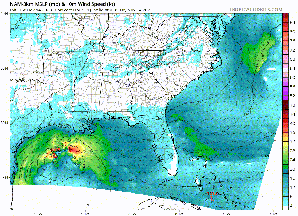
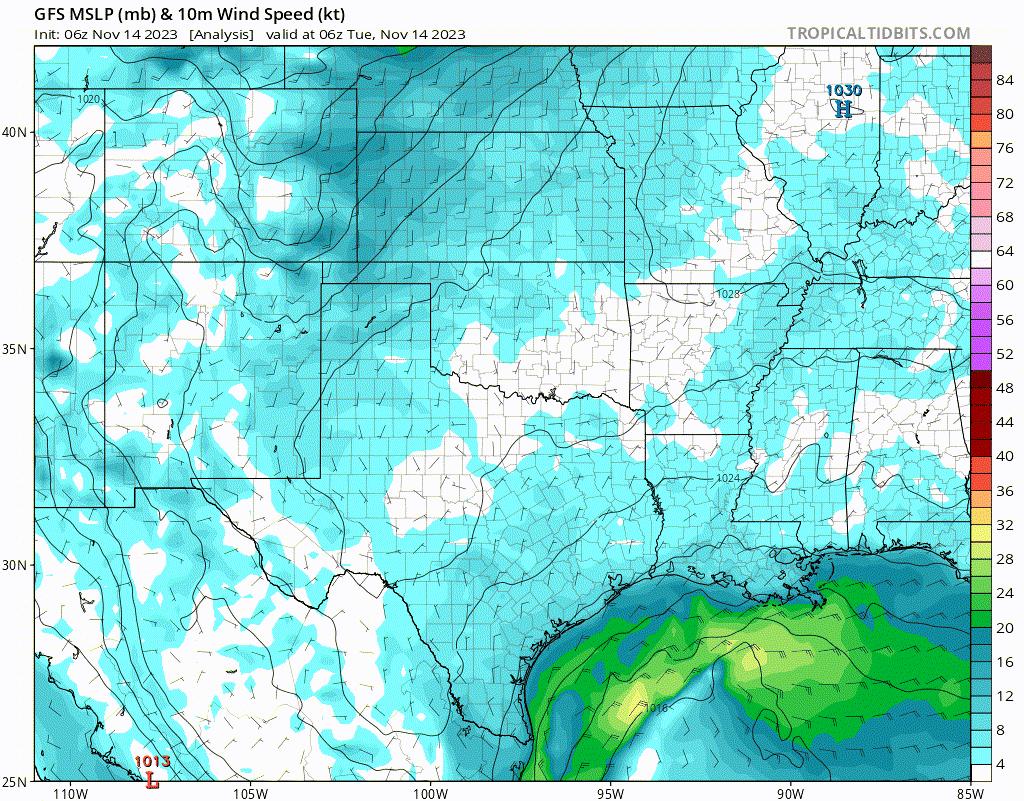
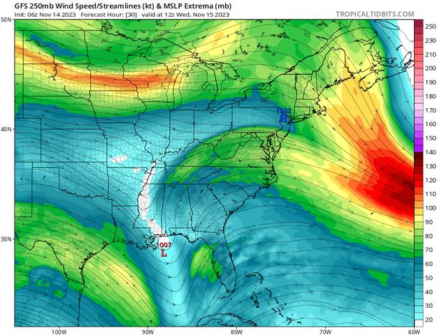
I was looking at the NAM model for a up coming rocket launch and I noticed it had a possible storm in the gulf, ok it's the NAM. I have been keeping a eye on the area for a while as the models have been showing a low sweeping through with strong winds for a while, some of the runs have had the winds nearly wrapping around it. But the winds will shear it, that was what I thought until I looked at the 200mb winds, just so happens the winds let up at the same time in fact there's a bit of a trough that could help.
Now it is the NAM model that picks it up the strongest not a global model so that is something to take in to account. The large global models often don't pick up the smaller quick forming storms due to resolution. Will it happen as bad as the NAM unlikely but it is worth keeping a eye on it over the next few days, if anything it's going to be windy and wet in the gulf.
NAM 10m Winds
GFS 10m winds
GFS 200mb winds
0 likes
-
Blown Away

- S2K Supporter
- Posts: 9861
- Joined: Wed May 26, 2004 6:17 am
Re: 2023 Global Model Runs Discussion (Out thru day 16)
12z GFS... Continues to develop the GOM low and possibly TS conditions over SFL then into a hurricane in the Atlantic... The SW Caribbean low is more of a messy rain event for the GA's...
0 likes
Hurricane Eye Experience: David 79, Irene 99, Frances 04, Jeanne 04, Wilma 05...
Hurricane Brush Experience: Andrew 92, Erin 95, Floyd 99, Matthew 16, Irma 17, Ian 22, Nicole 22…
Hurricane Brush Experience: Andrew 92, Erin 95, Floyd 99, Matthew 16, Irma 17, Ian 22, Nicole 22…
-
jlauderdal
- S2K Supporter
- Posts: 6771
- Joined: Wed May 19, 2004 5:46 am
- Location: NE Fort Lauderdale
- Contact:
Re: 2023 Global Model Runs Discussion (Out thru day 16)
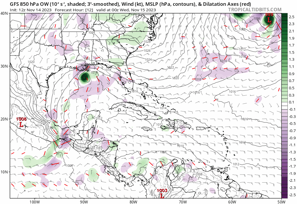
Blown Away wrote:[url]https://i.postimg.cc/9fgtW4JQ/gfs-ow850-watl-fh12-198.gif [/url]
12z GFS... Continues to develop the GOM low and possibly TS conditions over SFL then into a hurricane in the Atlantic... The SW Caribbean low is more of a messy rain event for the GA's...
One more cycle of this and the shutters are going up
0 likes
-
SouthFLTropics
- Category 5
- Posts: 4156
- Age: 48
- Joined: Thu Aug 14, 2003 8:04 am
- Location: Port St. Lucie, Florida
Re: 2023 Global Model Runs Discussion (Out thru day 16)
jlauderdal wrote:Blown Away wrote:[url]https://i.postimg.cc/9fgtW4JQ/gfs-ow850-watl-fh12-198.gif [/url]
12z GFS... Continues to develop the GOM low and possibly TS conditions over SFL then into a hurricane in the Atlantic... The SW Caribbean low is more of a messy rain event for the GA's...
One more cycle of this and the shutters are going up

At least you didn’t say you’d be firing up the generator… I may get a little concerned then. All kidding aside, this thing needs to scoot on out of here. I’m scheduled to sail out of Miami Friday evening on Freedom of the Seas. Think we’re going to be in for a rough ride. Drink up!!!
Sent from my iPhone using Tapatalk
0 likes
Fourth Generation Floridian...With lots of storm knowledge passed down from my elders...
Personal Storm History: David 79, Andrew 92, Erin 95, Floyd 99, Irene 99, Frances 04, Jeanne 04, Wilma 05, Matthew 16, Irma 17
Personal Storm History: David 79, Andrew 92, Erin 95, Floyd 99, Irene 99, Frances 04, Jeanne 04, Wilma 05, Matthew 16, Irma 17
-
Blown Away
- S2K Supporter
- Posts: 9861
- Joined: Wed May 26, 2004 6:17 am
Re: 2023 Global Model Runs Discussion (Out thru day 16)
SouthFLTropics wrote:jlauderdal wrote:Blown Away wrote:[url]https://i.postimg.cc/9fgtW4JQ/gfs-ow850-watl-fh12-198.gif [/url]
12z GFS... Continues to develop the GOM low and possibly TS conditions over SFL then into a hurricane in the Atlantic... The SW Caribbean low is more of a messy rain event for the GA's...
One more cycle of this and the shutters are going up
https://media2.giphy.com/media/lszAB3TzFtRaU/giphy.gif
At least you didn’t say you’d be firing up the generator… I may get a little concerned then. All kidding aside, this thing needs to scoot on out of here. I’m scheduled to sail out of Miami Friday evening on Freedom of the Seas. Think we’re going to be in for a rough ride. Drink up!!!
Sent from my iPhone using Tapatalk
It's gonna be a rough ride per the 12z Euro, nothing an open bar can't cure!
0 likes
Hurricane Eye Experience: David 79, Irene 99, Frances 04, Jeanne 04, Wilma 05...
Hurricane Brush Experience: Andrew 92, Erin 95, Floyd 99, Matthew 16, Irma 17, Ian 22, Nicole 22…
Hurricane Brush Experience: Andrew 92, Erin 95, Floyd 99, Matthew 16, Irma 17, Ian 22, Nicole 22…
-
jlauderdal
- S2K Supporter
- Posts: 6771
- Joined: Wed May 19, 2004 5:46 am
- Location: NE Fort Lauderdale
- Contact:
Re: 2023 Global Model Runs Discussion (Out thru day 16)
SouthFLTropics wrote:jlauderdal wrote:Blown Away wrote:[url]https://i.postimg.cc/9fgtW4JQ/gfs-ow850-watl-fh12-198.gif [/url]
12z GFS... Continues to develop the GOM low and possibly TS conditions over SFL then into a hurricane in the Atlantic... The SW Caribbean low is more of a messy rain event for the GA's...
One more cycle of this and the shutters are going up
https://media2.giphy.com/media/lszAB3TzFtRaU/giphy.gif
At least you didn’t say you’d be firing up the generator… I may get a little concerned then. All kidding aside, this thing needs to scoot on out of here. I’m scheduled to sail out of Miami Friday evening on Freedom of the Seas. Think we’re going to be in for a rough ride. Drink up!!!
Sent from my iPhone using Tapatalk
Have a good cruise, all systems go for the recovery efforts and cruise departure on Friday.
FRIDAY
MOSTLY SUNNY. HIGHS IN THE LOWER 80S.
FRIDAY NIGHT
MOSTLY CLEAR. LOWS AROUND 70.
SATURDAY
MOSTLY SUNNY. HIGHS IN THE LOWER 80S.
SATURDAY NIGHT THROUGH MONDAY
MOSTLY CLEAR. LOWS IN THE UPPER
60S. HIGHS IN THE LOWER 80S.
0 likes
-
Weathertracker96
- Tropical Low

- Posts: 23
- Joined: Mon Oct 16, 2023 3:41 pm
Re: 2023 Global Model Runs Discussion (Out thru day 16)
Blown Away wrote:SouthFLTropics wrote:jlauderdal wrote:One more cycle of this and the shutters are going up
https://media2.giphy.com/media/lszAB3TzFtRaU/giphy.gif
At least you didn’t say you’d be firing up the generator… I may get a little concerned then. All kidding aside, this thing needs to scoot on out of here. I’m scheduled to sail out of Miami Friday evening on Freedom of the Seas. Think we’re going to be in for a rough ride. Drink up!!!
Sent from my iPhone using Tapatalk
[url]https://i.postimg.cc/rws5f11F/fc05feb1-ebef-44db-b96b-069b8b8f1c1d.gif [/url]
It's gonna be a rough ride per the 12z Euro, nothing an open bar can't cure!
Looks like nasty weather setting up for east florida?
Is this the frontal system or could some form
& remain weak before crossing over the state?
0 likes
-
jlauderdal
- S2K Supporter
- Posts: 6771
- Joined: Wed May 19, 2004 5:46 am
- Location: NE Fort Lauderdale
- Contact:
Re: 2023 Global Model Runs Discussion (Out thru day 16)
Weathertracker96 wrote:Blown Away wrote:SouthFLTropics wrote:https://media2.giphy.com/media/lszAB3TzFtRaU/giphy.gif
At least you didn’t say you’d be firing up the generator… I may get a little concerned then. All kidding aside, this thing needs to scoot on out of here. I’m scheduled to sail out of Miami Friday evening on Freedom of the Seas. Think we’re going to be in for a rough ride. Drink up!!!
Sent from my iPhone using Tapatalk
[url]https://i.postimg.cc/rws5f11F/fc05feb1-ebef-44db-b96b-069b8b8f1c1d.gif [/url]
It's gonna be a rough ride per the 12z Euro, nothing an open bar can't cure!
Looks like nasty weather setting up for east florida?
Is this the frontal system or could some form
& remain weak before crossing over the state?
There is plenty going on here: Stalled front to the south, wave coming from the west with moisture coming from the east..the only thing we need is an arctic blast from the north and turn this to SN+
1 likes