This is getting more serious now.
2023 Global Model Runs Discussion (Out thru day 16)
Moderator: S2k Moderators
Forum rules

The posts in this forum are NOT official forecasts and should not be used as such. They are just the opinion of the poster and may or may not be backed by sound meteorological data. They are NOT endorsed by any professional institution or STORM2K. For official information, please refer to products from the National Hurricane Center and National Weather Service.
-
cycloneye

- Admin

- Posts: 139011
- Age: 67
- Joined: Thu Oct 10, 2002 10:54 am
- Location: San Juan, Puerto Rico
Re: 2023 Global Model Runs Discussion (Out thru day 16)
This is getting more serious now.
1 likes
Visit the Caribbean-Central America Weather Thread where you can find at first post web cams,radars
and observations from Caribbean basin members Click Here
and observations from Caribbean basin members Click Here
-
Category5Kaiju

- Category 5

- Posts: 3346
- Age: 22
- Joined: Thu Dec 24, 2020 12:45 pm
- Location: Seattle
Re: 2023 Global Model Runs Discussion (Out thru day 16)
cycloneye wrote:
This is getting more serious now.
We have yet to experience the 2023 Atlantic hurricane season, and at this point exactly how active it will be, what storms it will bring, and so forth remain a mystery. But one thing's pretty clear: this season does not seem to be afraid to produce pre-season storms.
1 likes
Unless explicitly stated, all information covered in my posts is based on my opinions and observations. Please refer to a professional meteorologist or an accredited weather research agency otherwise, especially if serious decisions must be made in the event of a potentially life-threatening tropical storm or hurricane.
-
wxman57

- Moderator-Pro Met

- Posts: 22480
- Age: 66
- Joined: Sat Jun 21, 2003 8:06 pm
- Location: Houston, TX (southwest)
Re: 2023 Global Model Runs Discussion (Out thru day 16)
Looks like a frontal low. Models have problems with this type of setup. Not concerned yet.
0 likes
-
cycloneye
- Admin
- Posts: 139011
- Age: 67
- Joined: Thu Oct 10, 2002 10:54 am
- Location: San Juan, Puerto Rico
Re: 2023 Global Model Runs Discussion (Out thru day 16)
The happy hour GFS 18Z has nothing. 
1 likes
Visit the Caribbean-Central America Weather Thread where you can find at first post web cams,radars
and observations from Caribbean basin members Click Here
and observations from Caribbean basin members Click Here
-
ThunderForce

- Tropical Storm

- Posts: 158
- Age: 25
- Joined: Tue Sep 27, 2022 6:20 pm
- Location: Florida Panhandle
Re: 2023 Global Model Runs Discussion (Out thru day 16)
The 00z GFS run also appears to have backed off somewhat with development for now.
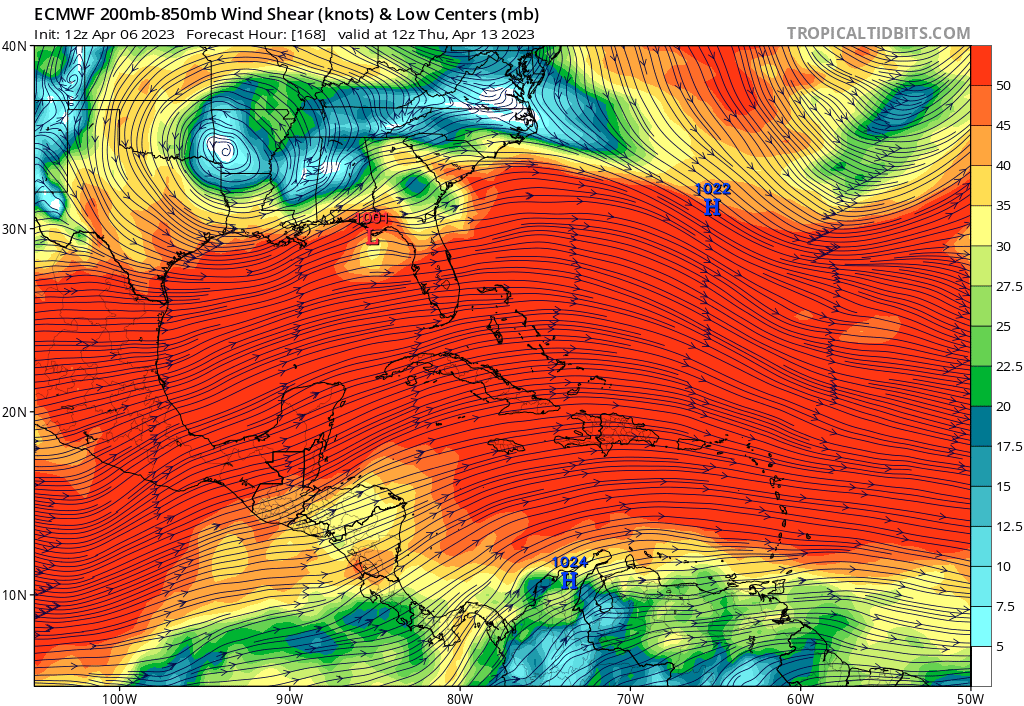
Although, I am pretty curious. I'm aware SSTs are rather favorable for this time of year right now, but doesn't wind shear tend to hinder development? Each GFS run seems to be showing a projected wind shear between 45 to 50+ kts in the majority of the Gulf and east of the Florida Peninsula during the period this seems to form, which is rather high.
00z and 18z seem to show the wind shear being strong enough that it appears to prevent the low from strengthening. Yet... GFS's previous runs such as 12z and 06z show a sudden small break in the wind shear in the area the low forms, and it seems to be just enough to allow it to start organizing.
EDIT: Now it seems that the current 06z run has went back to some development of the low. This time it seems it tries to develop near Louisiana and Mississippi before moving onto land.
0 likes
Please refer to the NWS, NHC, SPC or a professional meteorologist for information and decision making during storms.
Re: 2023 Global Model Runs Discussion (Out thru day 16)
cycloneye wrote:
This is getting more serious now.
Our locals in Orlando are talking about a "Could Be" possibility for this one.
0 likes
-
wxman57
- Moderator-Pro Met
- Posts: 22480
- Age: 66
- Joined: Sat Jun 21, 2003 8:06 pm
- Location: Houston, TX (southwest)
Re: 2023 Global Model Runs Discussion (Out thru day 16)
Note that the GFS & EC both have solid wind shear 50-70 kts over the Gulf and off the SE U.S. Coast. Looks like a frontal wave/low. Definitely not a tropical system.
1 likes
-
SFLcane

- S2K Supporter

- Posts: 9606
- Age: 46
- Joined: Sat Jun 05, 2010 1:44 pm
- Location: Lake Worth Florida
Re: 2023 Global Model Runs Discussion (Out thru day 16)
wxman57 wrote:Note that the GFS & EC both have solid wind shear 50-70 kts over the Gulf and off the SE U.S. Coast. Looks like a frontal wave/low. Definitely not a tropical system.

0 likes
-
wxman57
- Moderator-Pro Met
- Posts: 22480
- Age: 66
- Joined: Sat Jun 21, 2003 8:06 pm
- Location: Houston, TX (southwest)
Re: 2023 Global Model Runs Discussion (Out thru day 16)
WSW jet stream of 80-110 kts over the NE Gulf next week. Looks like a non-tropical west Gulf low. Not uncommon in winter and early spring.
Tremendous shear:
Tremendous shear:
2 likes

Re: 2023 Global Model Runs Discussion (Out thru day 16)
So some of the models projected this back on Wednesday and there is is cloud rotation on Thursday.
Looks dry and Shear might keep precip totals down but in Florida we have lawns.
Looks dry and Shear might keep precip totals down but in Florida we have lawns.
0 likes
-
ThunderForce
- Tropical Storm
- Posts: 158
- Age: 25
- Joined: Tue Sep 27, 2022 6:20 pm
- Location: Florida Panhandle
Re: 2023 Global Model Runs Discussion (Out thru day 16)
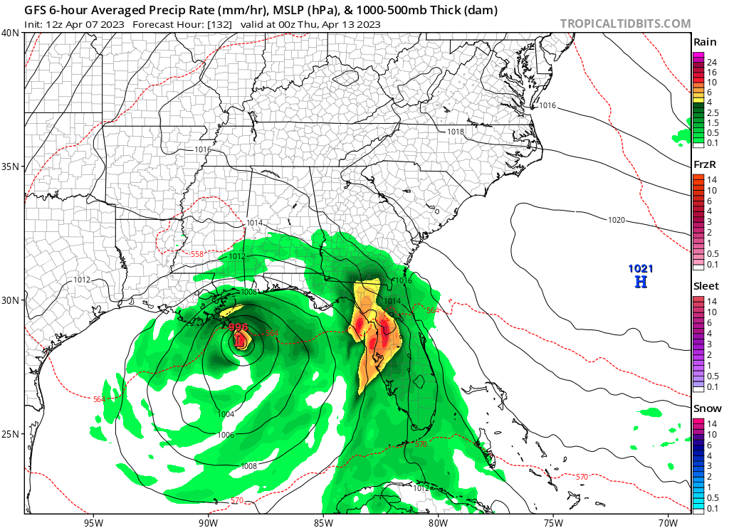
The current 00z GFS run seems to have this develop into what looks like a 994 mb tropical storm or possibly high-end tropical depression before making landfall in Louisiana, despite the very high wind shear in the Gulf.

0 likes
Please refer to the NWS, NHC, SPC or a professional meteorologist for information and decision making during storms.
-
wxman57
- Moderator-Pro Met
- Posts: 22480
- Age: 66
- Joined: Sat Jun 21, 2003 8:06 pm
- Location: Houston, TX (southwest)
Re: 2023 Global Model Runs Discussion (Out thru day 16)
I do think that a low pressure center will develop south of Louisiana next Tue-Wed, but it will not be remotely tropical. Winds may reach 35kts along the SE LA coast by Wednesday. We see these type of low centers often during the winter months. Wouldn't put it past the NHC calling it STS Arlene. Winds may peak at 35-40 kts, with little chance of becoming stronger, given the extremely high wind shear over it. High pressure to its north will produce the gradient north of the low center.
2 likes
-
cycloneye
- Admin
- Posts: 139011
- Age: 67
- Joined: Thu Oct 10, 2002 10:54 am
- Location: San Juan, Puerto Rico
Re: 2023 Global Model Runs Discussion (Out thru day 16)
Euro ensembles.

0 likes
Visit the Caribbean-Central America Weather Thread where you can find at first post web cams,radars
and observations from Caribbean basin members Click Here
and observations from Caribbean basin members Click Here
-
cycloneye
- Admin
- Posts: 139011
- Age: 67
- Joined: Thu Oct 10, 2002 10:54 am
- Location: San Juan, Puerto Rico
Re: 2023 Global Model Runs Discussion (Out thru day 16)
Already Accuweather is taking notice.
https://twitter.com/breakingweather/status/1644371545056321539
https://twitter.com/breakingweather/status/1644371545056321539
0 likes
Visit the Caribbean-Central America Weather Thread where you can find at first post web cams,radars
and observations from Caribbean basin members Click Here
and observations from Caribbean basin members Click Here
-
JetFuel_SE

- Category 1

- Posts: 262
- Age: 24
- Joined: Thu Apr 30, 2020 3:57 pm
Re: 2023 Global Model Runs Discussion (Out thru day 16)
wxman57 wrote:I do think that a low pressure center will develop south of Louisiana next Tue-Wed, but it will not be remotely tropical. Winds may reach 35kts along the SE LA coast by Wednesday. We see these type of low centers often during the winter months. Wouldn't put it past the NHC calling it STS Arlene. Winds may peak at 35-40 kts, with little chance of becoming stronger, given the extremely high wind shear over it. High pressure to its north will produce the gradient north of the low center.
Oh cmon Grandpa, let the kids enjoy the funny model runs.
3 likes
-
wxman57
- Moderator-Pro Met
- Posts: 22480
- Age: 66
- Joined: Sat Jun 21, 2003 8:06 pm
- Location: Houston, TX (southwest)
Re: 2023 Global Model Runs Discussion (Out thru day 16)
I think that the 12Z Euro looks pretty good. Winds 30-35 kts north of the low center along the coast Tue night. Completely non-tropical, though. Likely weakening by Wednesday PM. Winds of 30-35 kts will not make it inland. I suppose there may be a 30% chance NHC calls the low a STD or STS. Regardless, impacts will be the same. Rough weather along the coast and offshore north of the low. Don't trust anything the GFS puts out.
1 likes
-
AJC3

- Admin
- Posts: 3868
- Age: 60
- Joined: Tue Aug 31, 2004 7:04 pm
- Location: West Melbourne, Florida
- Contact:
Re: 2023 Global Model Runs Discussion (Out thru day 16)
wxman57 wrote:I think that the 12Z Euro looks pretty good. Winds 30-35 kts north of the low center along the coast Tue night. Completely non-tropical, though. Likely weakening by Wednesday PM. Winds of 30-35 kts will not make it inland. I suppose there may be a 30% chance NHC calls the low a STD or STS. Regardless, impacts will be the same. Rough weather along the coast and offshore north of the low. Don't trust anything the GFS puts out.
They'd really have to do some serious mental gymnastics not to analyze fronts attached to whatever develops. As you mentioned, the environment is decidedly baroclinic all the way down to the surface.
2 likes
-
AJC3
- Admin
- Posts: 3868
- Age: 60
- Joined: Tue Aug 31, 2004 7:04 pm
- Location: West Melbourne, Florida
- Contact:
Re: 2023 Global Model Runs Discussion (Out thru day 16)
cycloneye wrote:Already Accuweather is taking notice.
https://twitter.com/breakingweather/status/1644371545056321539
Are they not looking at the actual structure of this system? Sure, they can throw around terms like tropical and subtropical if only looking at the SLP fields, but it's ridiculously easy to infer an XTC with fronts from the temperature and moisture fields. Not surprisingly, the strongest solution (GFS) has, by far the greatest discontinuity in the temperature fields. (i.e. it shows the fronts most readily). This is clearly a gale/near-gale in the making.
0 likes
-
wxman57
- Moderator-Pro Met
- Posts: 22480
- Age: 66
- Joined: Sat Jun 21, 2003 8:06 pm
- Location: Houston, TX (southwest)
Re: 2023 Global Model Runs Discussion (Out thru day 16)
AJC3 wrote:wxman57 wrote:I think that the 12Z Euro looks pretty good. Winds 30-35 kts north of the low center along the coast Tue night. Completely non-tropical, though. Likely weakening by Wednesday PM. Winds of 30-35 kts will not make it inland. I suppose there may be a 30% chance NHC calls the low a STD or STS. Regardless, impacts will be the same. Rough weather along the coast and offshore north of the low. Don't trust anything the GFS puts out.
They'd really have to do some serious mental gymnastics not to analyze fronts attached to whatever develops. As you mentioned, the environment is decidedly baroclinic all the way down to the surface.
If the NHC starts seeing obs from offshore platforms at 30-35 kts, they tend to be a bit "lenient" with classification in the Gulf.
0 likes
Who is online
Users browsing this forum: Beef Stew and 65 guests