Tropical wave in the Eastern Atlantic (Is Invest 92L)

This is the general tropical discussion area. Anyone can take their shot at predicting a storms path.

Moderator: S2k Moderators

Forum rules

The posts in this forum are NOT official forecasts and should not be used as such. They are just the opinion of the poster and may or may not be backed by sound meteorological data. They are NOT endorsed by any professional institution or STORM2K. For official information, please refer to products from the National Hurricane Center and National Weather Service.

Help Support Storm2K
Message
Author
User avatar
TheAustinMan
Category 4
Category 4
Posts: 997
Age: 24
Joined: Mon Jul 08, 2013 4:26 pm
Location: United States
Contact:

Tropical wave in the Eastern Atlantic (Is Invest 92L)

#1 Postby TheAustinMan » Thu Jun 15, 2023 8:42 am

With sea surface temperatures over the tropical Atlantic and some model support for tropical cyclogenesis over the MDR, in addition to its appearance on the NHC Tropical Weather Outlook this morning, I figured it'd be a good time to kick off this thread.

Summary
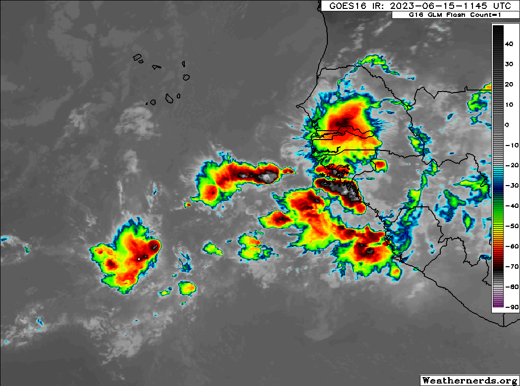
  • Where it is now: The tropical wave is over the tropical coast of western Africa, in the vicinity of Guinea-Bissau, Guinea, The Gambia, and Senegal. It has not yet been marked by the Tropical Analysis & Forecast Branch (TAFB), but likely will be soon once it moves offshore. The tropical wave currently exhibits modest convective activity and is located within a bubble of locally higher total precipitable water values that extends southwestward offshore along a monsoon trough.
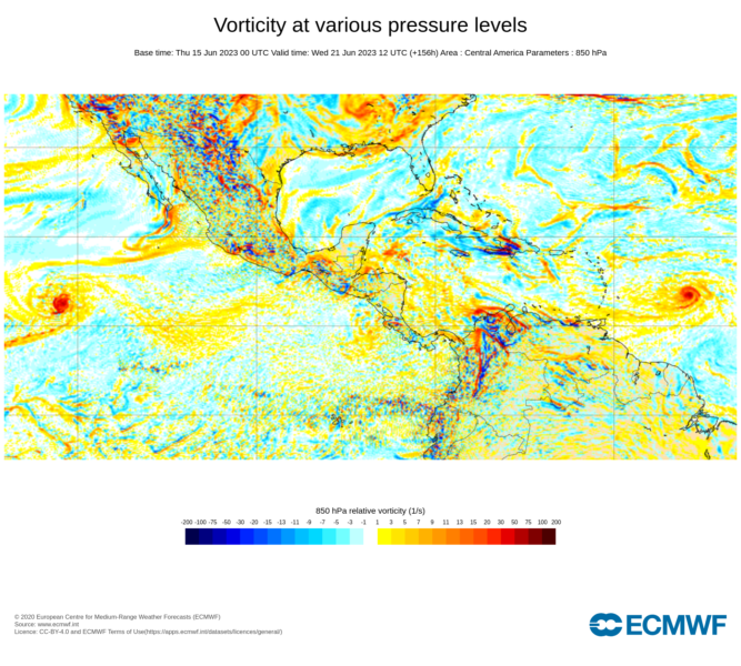
  • Where it will be: The wave is expected to move off the West African coast later today and should be completely offshore by West African sunrise tomorrow. The disturbance will likely remain entangled within a monsoon trough during at least its first few days offshore, and will take some time to consolidate (if it does at all) as it tracks west. During this time, the wave is expected to sweep in vorticity from the surrounding monsoon trough; you can see one particular vorticity maximum at bottom-left in the image below that will likely be absorbed in some form by the tropical wave. The precise position of any resulting system will depend on where the wave consolidates, and models notoriously have a difficult time accurately depicting the evolution of tropical waves that have not left the African coast. That said, the vorticity maximum associated with the wave is expected to remain around 10–13°N over the next few days, reaching roughly 40°W sometime on Monday. Models are in decent agreement in a mid-level trough / frontal zone dipping down to around 30N over the central Atlantic towards the end of the week (EPS, GEFS), but whether this has significant implications on the storm's future track depends largely on the storm's intensity, assuming it develops at all. The disturbance may reach 60°W (roughly the longitude of the Leeward Islands) sometime between Thursday and next week.
  • Model support: Not all of the deterministic guidance shows tropical cyclogenesis, though both the GFS and ECMWF show a tropical cyclone developing before the wave reaches the Lesser Antilles. Many of the EPS ensemble members depict the development of a low-pressure area tracking towards the Lesser Antilles, with a varying range of intensities ranging from disturbance to tropical depression to even low-end hurricane. The GEFS members also depict a generally weak disturbance taking similar, slightly north-of-west trajectories potentially towards the Lesser Antilles.
  • What to watch for: While it is enticing to look at specific model depictions of the tropical wave developing into a fully-fledged tropical cyclone or even hurricane, as with any new tropical wave the main thing to watch is how convection develops around the wave, whether or not it can consolidate vorticity, and whether or not it can detach from the monsoon trough / ITCZ. Answers to those questions will become more apparent over the coming days.

Composite of total precipitable water overlaid on visible satellite imagery with surface observations valid ~12/13 UTC June 15. Source: SSEC RealEarth
Image

And, per the latest NHC Tropical Weather Outlook:
Forecaster Bucci at the National Hurricane Center (800 AM EDT Thu Jun 15 2023) wrote:1. Eastern Tropical Atlantic:
A tropical wave is forecast to move off the west coast of Africa later today and early Friday. Environmental conditions are expected to be conducive for gradual development of this system while it moves generally westward to west-northwestward at 15 to 20 mph across the eastern and central tropical Atlantic during the early to middle part of next week.
* Formation chance through 48 hours...low...near 0 percent.
* Formation chance through 7 days...low...20 percent.

15 likes   
ImageImageImage
Treat my opinions with a grain of salt. For official information see your local weather service.

User avatar
SFLcane
S2K Supporter
S2K Supporter
Posts: 9606
Age: 46
Joined: Sat Jun 05, 2010 1:44 pm
Location: Lake Worth Florida

Re: Tropical wave over West Africa (NHC: 0/20)

#2 Postby SFLcane » Thu Jun 15, 2023 8:51 am

06z euro ensembles really like this wave.

Image
2 likes   

User avatar
toad strangler
S2K Supporter
S2K Supporter
Posts: 4162
Joined: Sun Jul 28, 2013 3:09 pm
Location: Earth
Contact:

Re: Tropical wave over West Africa (NHC: 0/20)

#3 Postby toad strangler » Thu Jun 15, 2023 8:52 am

Image
4 likes   

User avatar
SFLcane
S2K Supporter
S2K Supporter
Posts: 9606
Age: 46
Joined: Sat Jun 05, 2010 1:44 pm
Location: Lake Worth Florida

Re: Tropical wave over West Africa (NHC: 0/20)

#4 Postby SFLcane » Thu Jun 15, 2023 9:08 am

1 likes   

User avatar
SFLcane
S2K Supporter
S2K Supporter
Posts: 9606
Age: 46
Joined: Sat Jun 05, 2010 1:44 pm
Location: Lake Worth Florida

Re: Tropical wave over West Africa [NHC: 0%/20%]

#5 Postby SFLcane » Thu Jun 15, 2023 10:13 am

Image
1 likes   

User avatar
SFLcane
S2K Supporter
S2K Supporter
Posts: 9606
Age: 46
Joined: Sat Jun 05, 2010 1:44 pm
Location: Lake Worth Florida

Re: Tropical wave over West Africa (NHC: 0/20)

#6 Postby SFLcane » Thu Jun 15, 2023 11:57 am

Gfs model be like.....

Image
2 likes   

User avatar
tiger_deF
Category 1
Category 1
Posts: 437
Age: 23
Joined: Tue Sep 27, 2016 11:47 am

Re: Tropical wave over West Africa (NHC: 0/20)

#7 Postby tiger_deF » Thu Jun 15, 2023 12:03 pm

If the GFS is to be believed, in 4 days we will have two developing cyclones in the Atlantic, one in the deep MDR and one right in the Western Caribbean. While the GFS has known issues, having two simultaneous cyclones in mid to late June (which would be our third and fourth of the year!) might be a portent to an active season.
0 likes   

IcyTundra
Category 3
Category 3
Posts: 885
Joined: Mon Jun 07, 2021 9:32 pm
Location: Dickinson, Texas

Re: Tropical wave over West Africa (NHC: 0/20)

#8 Postby IcyTundra » Thu Jun 15, 2023 12:12 pm

GFS isn't that bad every model has issues.
4 likes   

User avatar
wxman57
Moderator-Pro Met
Moderator-Pro Met
Posts: 22482
Age: 66
Joined: Sat Jun 21, 2003 8:06 pm
Location: Houston, TX (southwest)

Re: Tropical wave over West Africa (NHC: 0/20)

#9 Postby wxman57 » Thu Jun 15, 2023 12:25 pm

IcyTundra wrote:GFS isn't that bad every model has issues.


Each model has its own special characteristics. Since the last GFS "upgrade" it has been developing spurious cyclones worldwide. You absolutely cannot trust it if it is the only model indicating genesis. It's worse than the Canadian model used to be.
6 likes   

ChrisH-UK
Category 1
Category 1
Posts: 423
Joined: Sat May 29, 2021 8:22 am

Re: Tropical wave over West Africa (NHC: 0/20)

#10 Postby ChrisH-UK » Thu Jun 15, 2023 12:32 pm

So GFS has 2 storms in a week, well here is the ECMWF Tropical Cyclone probability for the same period of time one in the MDR and one in the Caribbean.

GFS

Image

ECMWF

Image

Source - https://charts.ecmwf.int/permalinks/tro ... ng-genesis)-77993
3 likes   

User avatar
DorkyMcDorkface
Category 2
Category 2
Posts: 698
Age: 26
Joined: Mon Sep 30, 2019 1:32 pm
Location: Mid-Atlantic

Re: Tropical wave over West Africa (NHC: 0/20)

#11 Postby DorkyMcDorkface » Thu Jun 15, 2023 12:32 pm

6 likes   
Floyd 1999 | Isabel 2003 | Hanna 2008 | Irene 2011 | Sandy 2012 | Isaias 2020

ChrisH-UK
Category 1
Category 1
Posts: 423
Joined: Sat May 29, 2021 8:22 am

Re: Tropical wave over West Africa (NHC: 0/20)

#12 Postby ChrisH-UK » Thu Jun 15, 2023 12:59 pm

Just looked at the ECMWF hi res vorticity at 850mb and It shows a area of energy that came from Honduras and now over the Caribbean in the same place as GFS

Image
0 likes   

zzzh
Category 2
Category 2
Posts: 529
Joined: Thu Sep 02, 2021 1:13 pm

Re: Tropical wave over West Africa (NHC: 0/20)

#13 Postby zzzh » Thu Jun 15, 2023 1:28 pm

 https://twitter.com/AndyHazelton/status/1669410251723124737


Agreed with Andy here. 20% seems too low.
1 likes   

User avatar
toad strangler
S2K Supporter
S2K Supporter
Posts: 4162
Joined: Sun Jul 28, 2013 3:09 pm
Location: Earth
Contact:

Re: Tropical wave over West Africa (NHC: 0/20)

#14 Postby toad strangler » Thu Jun 15, 2023 1:32 pm

zzzh wrote:https://twitter.com/AndyHazelton/status/1669410251723124737
Agreed with Andy here. 20% seems too low.


If it weren't for the calendar I'm sure this would be a better tasting fruit than lemon.
1 likes   

User avatar
wxman57
Moderator-Pro Met
Moderator-Pro Met
Posts: 22482
Age: 66
Joined: Sat Jun 21, 2003 8:06 pm
Location: Houston, TX (southwest)

Re: Tropical wave over West Africa (NHC: 0/20)

#15 Postby wxman57 » Thu Jun 15, 2023 1:43 pm

12Z EC is stronger with the wave moving offshore Africa today. It has a TS approaching the NE Caribbean next Thursday night. Similar position with the 12Z GFS. Canadian is a little slower and much weaker. I'm still thinking this is the system which will likely become Bret, not anything in the western Caribbean.
5 likes   

User avatar
Nimbus
Category 5
Category 5
Posts: 4928
Joined: Mon Jul 19, 2004 10:54 am

Re: Tropical wave over West Africa (NHC: 0/20)

#16 Postby Nimbus » Thu Jun 15, 2023 3:35 pm

Tropical mid Atlantic is currently pretty dry and this time of year the seasonally drier environment usually doesn't leave much room for development until the waves reach the western Caribbean.
1 likes   

User avatar
Spacecoast
Category 2
Category 2
Posts: 687
Joined: Thu Aug 31, 2017 2:03 pm

Re: Tropical wave over West Africa (NHC: 0/20)

#17 Postby Spacecoast » Thu Jun 15, 2023 4:18 pm

Nimbus wrote:Tropical mid Atlantic is currently pretty dry and this time of year the seasonally drier environment usually doesn't leave much room for development until the waves reach the western Caribbean.

Image
0 likes   

User avatar
wxman57
Moderator-Pro Met
Moderator-Pro Met
Posts: 22482
Age: 66
Joined: Sat Jun 21, 2003 8:06 pm
Location: Houston, TX (southwest)

Re: Tropical wave over West Africa (NHC: 0/20)

#18 Postby wxman57 » Thu Jun 15, 2023 4:26 pm

Nimbus wrote:Tropical mid Atlantic is currently pretty dry and this time of year the seasonally drier environment usually doesn't leave much room for development until the waves reach the western Caribbean.


Yeah, it's best shot at being a TS may be next Wed/Thu before reaching the NE Caribbean. GFS and Euro weaken it as it reaches the islands. Environment there may not be as favorable.
2 likes   

User avatar
Hurricane2022
Category 4
Category 4
Posts: 921
Joined: Tue Aug 23, 2022 11:38 pm
Location: Araçatuba, Brazil

Re: Tropical wave over West Africa (NHC: 0/20)

#19 Postby Hurricane2022 » Thu Jun 15, 2023 5:39 pm

Image
Cycloneye needs to get his account back ASAP!!!
0 likes   
Sorry for the bad English sometimes...!
For reliable and detailed information for any meteorological phenomenon, please consult the National Hurricane Center, Joint Typhoon Warning Center , or your local Meteo Center.

--------

Una cvm Christo, pro Christo, et in Christo. Sit nomen Domini benedictvm.

zzzh
Category 2
Category 2
Posts: 529
Joined: Thu Sep 02, 2021 1:13 pm

Re: Tropical wave over West Africa (NHC: 0/20)

#20 Postby zzzh » Thu Jun 15, 2023 5:47 pm

Classic happy hour GFS. :lol:
3 likes   


Return to “Talkin' Tropics”

Who is online

Users browsing this forum: Cat5James, hcane27 and 241 guests