
2023 TCR's
Moderator: S2k Moderators
Forum rules

The posts in this forum are NOT official forecasts and should not be used as such. They are just the opinion of the poster and may or may not be backed by sound meteorological data. They are NOT endorsed by any professional institution or STORM2K. For official information, please refer to products from the National Hurricane Center and National Weather Service.
Re: 2023 TCR's: Hurricane Otis is up / Peak was 140kt
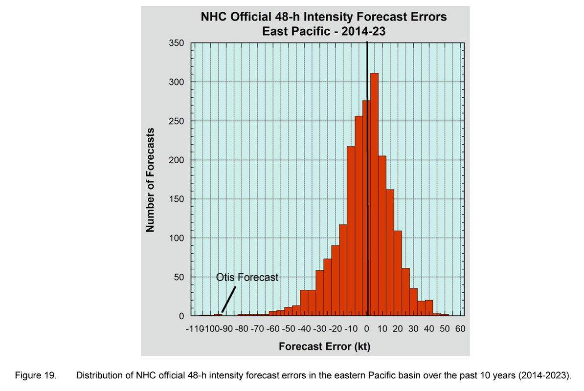
To highlight how anomalous Otis's intensity forecast error is, even at 48h:
1 likes
Re: 2023 TCR's: Hurricane Otis is up / Peak was 140kt
Also, why does the thread title say 140 kt peak when the TCR has 145 kt peak for 25/0300z and 25/0600z?
0 likes
-
cycloneye

- Admin

- Posts: 139080
- Age: 67
- Joined: Thu Oct 10, 2002 10:54 am
- Location: San Juan, Puerto Rico
Re: 2023 TCR's: Hurricane Otis is up / Peak was 140kt
Teban54 wrote:Also, why does the thread title say 140 kt peak when the TCR has 145 kt peak for 25/0300z and 25/0600z?
Fixed it.
0 likes
Visit the Caribbean-Central America Weather Thread where you can find at first post web cams,radars
and observations from Caribbean basin members Click Here
and observations from Caribbean basin members Click Here
-
cheezyWXguy

- Category 5

- Posts: 5532
- Joined: Mon Feb 13, 2006 12:29 am
- Location: Dallas, TX
Re: 2023 TCR's: Hurricane Otis is up / Peak was 140kt
Teban54 wrote:Also, why does the thread title say 140 kt peak when the TCR has 145 kt peak for 25/0300z and 25/0600z?
Guessing he meant landfall intensity, which was 140kt
0 likes
-
Yellow Evan

- Professional-Met

- Posts: 15952
- Age: 25
- Joined: Fri Jul 15, 2011 12:48 pm
- Location: Henderson, Nevada/Honolulu, HI
- Contact:
Re: 2023 TCR's: Hurricane Otis is up / Peak was 145kt
Not a fan of raw ADT being used to justify peak.
0 likes
-
CrazyC83
- Professional-Met
- Posts: 33393
- Joined: Tue Mar 07, 2006 11:57 pm
- Location: Deep South, for the first time!
Re: 2023 TCR's: Hurricane Otis is up / Peak was 145kt
Yellow Evan wrote:Not a fan of raw ADT being used to justify peak.
There was justification here since at 1800Z, when Recon was in the storm, standard Dvorak supported cat 1, raw ADT supported cat 3 and Recon found winds of 100 kt (and 115 kt at 2100Z when it departed).
0 likes
-
cycloneye
- Admin
- Posts: 139080
- Age: 67
- Joined: Thu Oct 10, 2002 10:54 am
- Location: San Juan, Puerto Rico
Re: 2023 TCR's: Hurricane Otis is up / Peak was 145kt
0 likes
Visit the Caribbean-Central America Weather Thread where you can find at first post web cams,radars
and observations from Caribbean basin members Click Here
and observations from Caribbean basin members Click Here
-
TheAustinMan

- Category 4

- Posts: 997
- Age: 24
- Joined: Mon Jul 08, 2013 4:26 pm
- Location: United States
- Contact:
Re: 2023 TCR's: Hurricane Otis is up / Peak was 145kt
It was sobering to see the damage images in the TCR today, and it's a reminder that Acapulco is still heavily damaged even months after. Big kudos to Miriam and Valente of the Servicio Mareográfico Nacional UNAM for recovering the meteorological data from Acapulco that astonishingly recorded a 178 kt wind gust.
Shortly after Hurricane Otis rapidly intensified and impacted Acapulco, I was curious as to why Otis, which looked nothing like a storm that was primed to rapidly intensify the previous day, was able to strengthen so quickly and reach Category 5 intensity with virtually no model support for that outcome. Looking at the satellite imagery and model data, I think there's a possible mechanism that explains how such a disorganized-looking system was able to acquire a hurricane-like low-level structure and how this rapidly grew into a major hurricane.
In short, a few days before Otis, Hurricane Norma was a major hurricane that ultimately struck Baja California (albeit as a weaker storm). While Norma was around, outflow from the storm forced a ridge that was over the Gulf of Mexico southward. This brought a lot of dry and stable air that was associated with the ridge into the eastern Pacific. Much of this dry air entered the eastern Pacific, where it initially prevented Otis from growing vertically. That explains why half of Otis was just low clouds on October 23 while shear kept most of the deep convection to the west. With Otis blocked from growing vertically, its circulation reeled in abundant moisture that stayed concentrated in the lower troposphere, and all that latent heat release from the low-level clouds was dedicated to building that low-level vortex, sneakily intensifying the circulation while avoiding the stronger wind shear aloft.
Subtlety, there was actually a slight westerly wind in those dry mid-levels. With all the deep convection focused to the west of the storm, this wind may have blown cloud droplets from that strong convection east right over the circulation, and crucially, exactly where the dry and stable air was. When those droplets reached the dry layer, they evaporated, moistening the air and cooling it. This was a gradual process but it may have had a profound effect: the dry and stable air allowed moisture to "stockpile" in the low levels and organize an exceptionally well-organized circulation, but the evaporation cooling destabilized the layer aloft, eventually setting the stage for the convection to go boom on the night of October 23-24. This delay was well timed: it happened essentially right when Otis crossed into waters with high (>50 kJ/cm2) oceanic heat content and when the deep-layer wind shear decreased, giving Otis an virtually perfect environment to rapidly strengthen with a well-organized low-level circulation already acquired and a full head of steam.

https://twitter.com/ATXHarrisonTran/status/1765904163362263162
Shortly after Hurricane Otis rapidly intensified and impacted Acapulco, I was curious as to why Otis, which looked nothing like a storm that was primed to rapidly intensify the previous day, was able to strengthen so quickly and reach Category 5 intensity with virtually no model support for that outcome. Looking at the satellite imagery and model data, I think there's a possible mechanism that explains how such a disorganized-looking system was able to acquire a hurricane-like low-level structure and how this rapidly grew into a major hurricane.
In short, a few days before Otis, Hurricane Norma was a major hurricane that ultimately struck Baja California (albeit as a weaker storm). While Norma was around, outflow from the storm forced a ridge that was over the Gulf of Mexico southward. This brought a lot of dry and stable air that was associated with the ridge into the eastern Pacific. Much of this dry air entered the eastern Pacific, where it initially prevented Otis from growing vertically. That explains why half of Otis was just low clouds on October 23 while shear kept most of the deep convection to the west. With Otis blocked from growing vertically, its circulation reeled in abundant moisture that stayed concentrated in the lower troposphere, and all that latent heat release from the low-level clouds was dedicated to building that low-level vortex, sneakily intensifying the circulation while avoiding the stronger wind shear aloft.
Subtlety, there was actually a slight westerly wind in those dry mid-levels. With all the deep convection focused to the west of the storm, this wind may have blown cloud droplets from that strong convection east right over the circulation, and crucially, exactly where the dry and stable air was. When those droplets reached the dry layer, they evaporated, moistening the air and cooling it. This was a gradual process but it may have had a profound effect: the dry and stable air allowed moisture to "stockpile" in the low levels and organize an exceptionally well-organized circulation, but the evaporation cooling destabilized the layer aloft, eventually setting the stage for the convection to go boom on the night of October 23-24. This delay was well timed: it happened essentially right when Otis crossed into waters with high (>50 kJ/cm2) oceanic heat content and when the deep-layer wind shear decreased, giving Otis an virtually perfect environment to rapidly strengthen with a well-organized low-level circulation already acquired and a full head of steam.
https://twitter.com/ATXHarrisonTran/status/1765904163362263162
8 likes


Treat my opinions with a grain of salt. For official information see your local weather service.
-
CrazyC83
- Professional-Met
- Posts: 33393
- Joined: Tue Mar 07, 2006 11:57 pm
- Location: Deep South, for the first time!
Re: 2023 TCR's: Hurricane Otis is up / Peak was 145kt
The landfall intensity was challenging because of the lack of reliable sustained winds, but the 178 kt gust clearly supports a very powerful hurricane. I know in most NHC advisories, 175 kt gusts are used with 145 kt sustained winds, but there could have been funneling or elevation issues. I'd have probably gone 150 kt for the peak intensity leaning closer to the ADT knowing satellite severely underestimated earlier with Recon, but there is definitely inherent uncertainty when all we have is satellite.
0 likes

Re: 2023 TCR's: Hurricane Otis is up / Peak was 145kt
Tammy and Pilar are up.
https://www.nhc.noaa.gov/data/tcr/AL202023_Tammy.pdf
https://www.nhc.noaa.gov/data/tcr/EP192023_Pilar.pdf
Tammy's peak increased to 95 kts, I don't remember Pilar well enough to notice any changes.
https://www.nhc.noaa.gov/data/tcr/AL202023_Tammy.pdf
https://www.nhc.noaa.gov/data/tcr/EP192023_Pilar.pdf
Tammy's peak increased to 95 kts, I don't remember Pilar well enough to notice any changes.
2 likes

Re: 2023 TCR's: Hurricane Otis is up / Peak was 145kt
ljmac75 wrote:I don't remember Pilar well enough to notice any changes.
brutal
0 likes
blonde stacey (xe/xem/xir)
Re: 2023 TCR's: Hurricane Otis is up / Peak was 145kt
all that's left
atlantic: franklin/lee/philippe
pacific: lidia/norma
can anyone guess the order of release?
atlantic: franklin/lee/philippe
pacific: lidia/norma
can anyone guess the order of release?
0 likes
blonde stacey (xe/xem/xir)
Re: 2023 TCR's
This might be kind of a nitpick but one thing I noticed in the Otis TCR is that it mentions how Otis surpassed Wilma as the costliest tropical cyclone in Mexico but doesn't provide any number on the cost of Wilma in Mexico. The 2005 report for Wilma, which is linked in that section of the Otis report, also does not give any number.
0 likes
-
MarioProtVI
- Category 2

- Posts: 670
- Age: 22
- Joined: Sun Sep 29, 2019 7:33 pm
- Location: New Jersey
Re: 2023 TCR's
Not really a fan of how they didn’t mention the SAR pass with Tammy which, even counting for the fact it’s in its infancy, a 126 kt reading likely supports 100 kt though. Better then no upgrade though I guess. The ET part also got removed and it was in fact still a TC (debatable given the fronts nearby which probably at least made it become a SS for a day IMO).
0 likes

Re: 2023 TCR's: Hurricane Otis is up / Peak was 145kt
ljmac75 wrote:Tammy and Pilar are up.
https://www.nhc.noaa.gov/data/tcr/AL202023_Tammy.pdf
https://www.nhc.noaa.gov/data/tcr/EP192023_Pilar.pdf
Tammy's peak increased to 95 kts, I don't remember Pilar well enough to notice any changes.
Tammy is still likely underestimated but hey, at least they actually bumped up an intensity estimate.
I haven’t been thrilled with the TCR results this year. Many storms that I thought should’ve had intensity updates, either up (Calvin, Jova, Jose) or down (Idalia) were kept at this operational intensities. But many of those were unfortunately limited by only having ADT estimates (which sucked last year) and a few satellite passes available for post-season analysis, so I guess I understand why the NHC kept them the way they were. I’m just hoping ADT isn’t as frustrating this year.
0 likes
Irene '11 Sandy '12 Hermine '16 5/15/2018 Derecho Fay '20 Isaias '20 Elsa '21 Henri '21 Ida '21
I am only a meteorology enthusiast who knows a decent amount about tropical cyclones. Look to the professional mets, the NHC, or your local weather office for the best information.
I am only a meteorology enthusiast who knows a decent amount about tropical cyclones. Look to the professional mets, the NHC, or your local weather office for the best information.
-
CrazyC83
- Professional-Met
- Posts: 33393
- Joined: Tue Mar 07, 2006 11:57 pm
- Location: Deep South, for the first time!
Re: 2023 TCR's: Hurricane Otis is up / Peak was 145kt
aspen wrote:ljmac75 wrote:Tammy and Pilar are up.
https://www.nhc.noaa.gov/data/tcr/AL202023_Tammy.pdf
https://www.nhc.noaa.gov/data/tcr/EP192023_Pilar.pdf
Tammy's peak increased to 95 kts, I don't remember Pilar well enough to notice any changes.
Tammy is still likely underestimated but hey, at least they actually bumped up an intensity estimate.
I haven’t been thrilled with the TCR results this year. Many storms that I thought should’ve had intensity updates, either up (Calvin, Jova, Jose) or down (Idalia) were kept at this operational intensities. But many of those were unfortunately limited by only having ADT estimates (which sucked last year) and a few satellite passes available for post-season analysis, so I guess I understand why the NHC kept them the way they were. I’m just hoping ADT isn’t as frustrating this year.
In the case of Tammy, the ADT was in line with the 95 kt estimated. Other Dvorak estimates were T5.0. Only SATCON, which is not commonly used on its own, supported major hurricane intensity.
There were a lot of frustrating storms in 2023 that had no Recon at their peak, or questionable data. Jova was likely at least 150 kt at its peak.
1 likes
Re: 2023 TCR's: Hurricane Otis is up / Peak was 145kt
CrazyC83 wrote:aspen wrote:ljmac75 wrote:Tammy and Pilar are up.
https://www.nhc.noaa.gov/data/tcr/AL202023_Tammy.pdf
https://www.nhc.noaa.gov/data/tcr/EP192023_Pilar.pdf
Tammy's peak increased to 95 kts, I don't remember Pilar well enough to notice any changes.
Tammy is still likely underestimated but hey, at least they actually bumped up an intensity estimate.
I haven’t been thrilled with the TCR results this year. Many storms that I thought should’ve had intensity updates, either up (Calvin, Jova, Jose) or down (Idalia) were kept at this operational intensities. But many of those were unfortunately limited by only having ADT estimates (which sucked last year) and a few satellite passes available for post-season analysis, so I guess I understand why the NHC kept them the way they were. I’m just hoping ADT isn’t as frustrating this year.
In the case of Tammy, the ADT was in line with the 95 kt estimated. Other Dvorak estimates were T5.0. Only SATCON, which is not commonly used on its own, supported major hurricane intensity.
There were a lot of frustrating storms in 2023 that had no Recon at their peak, or questionable data. Jova was likely at least 150 kt at its peak.
What are your thoughts on Jova's report
0 likes
blonde stacey (xe/xem/xir)
Re: 2023 TCR's
Lidia is up: https://www.nhc.noaa.gov/data/tcr/EP152023_Lidia.pdf
Peak and landfall intensity kept the same.
Peak and landfall intensity kept the same.
0 likes
Re: 2023 TCR's
ljmac75 wrote:Lidia is up: https://www.nhc.noaa.gov/data/tcr/EP152023_Lidia.pdf
Peak and landfall intensity kept the same.
Yawn, next
0 likes
blonde stacey (xe/xem/xir)
Re: 2023 TCR's
...And here's Norma on the same day as Lidia. I think that's a wrap for the EPAC. https://www.nhc.noaa.gov/data/tcr/EP172023_Norma.pdf
1 likes
Who is online
Users browsing this forum: JaviT and 224 guests