

Low Pressure / Tropical Wave WSW of Cabo Verde (is Invest 95L)
Moderator: S2k Moderators
Forum rules

The posts in this forum are NOT official forecasts and should not be used as such. They are just the opinion of the poster and may or may not be backed by sound meteorological data. They are NOT endorsed by any professional institution or STORM2K. For official information, please refer to products from the National Hurricane Center and National Weather Service.

Re: Tropical Wave south of Cabo Verde
0z GEFS a bit more active than the last few runs, but still not as much as Euro ensembles. None of them are strong, and most dissipate before entering the Caribbean.
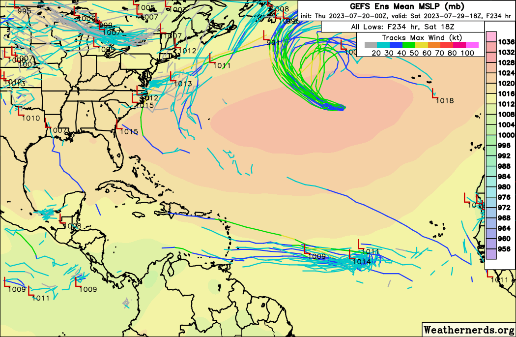
Compared to 18z:
Edit: 0z Euro's vort signature is a lot more pronounced than before:
Edit 2: 0z EPS, about the same for MDR as 12z, but significantly weaker once it enters the Caribbean as virtually no members cross north of the GA.
Compared to 18z:
Edit: 0z Euro's vort signature is a lot more pronounced than before:
Edit 2: 0z EPS, about the same for MDR as 12z, but significantly weaker once it enters the Caribbean as virtually no members cross north of the GA.
1 likes
-
cycloneye

- Admin

- Posts: 139090
- Age: 67
- Joined: Thu Oct 10, 2002 10:54 am
- Location: San Juan, Puerto Rico
Re: Tropical Wave SW of Cabo Verde
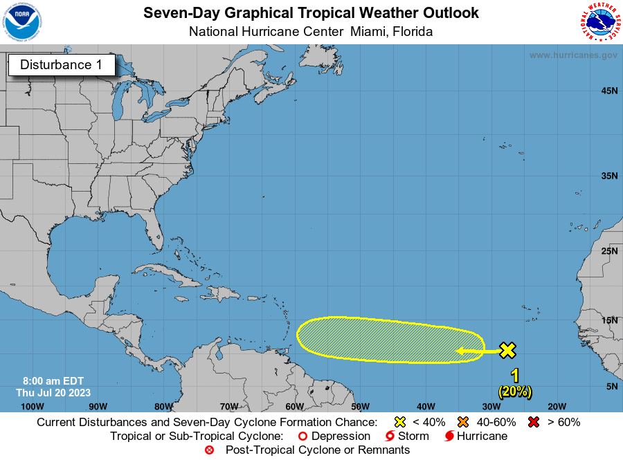
Tropical Weather Outlook
NWS National Hurricane Center Miami FL
800 AM EDT Thu Jul 20 2023
For the North Atlantic...Caribbean Sea and the Gulf of Mexico:
Active Systems:
The National Hurricane Center is issuing advisories on Tropical
Storm Don, located over the central Atlantic.
1. Eastern Tropical Atlantic:
A tropical wave located a few hundred miles southwest of the Cabo
Verde Islands is currently interacting with the Intertropical
Convergence Zone. The combination of these features is producing an
elongated area of showers and thunderstorms over the eastern
and central tropical Atlantic. While dry air to the north may
prevent significant organization during the next couple of days,
environmental conditions could become more conducive for some
development this weekend as the system moves westward across
the central tropical Atlantic.
* Formation chance through 48 hours...low...near 0 percent.
* Formation chance through 7 days...low...20 percent.
Forecaster Brown
1 likes
Visit the Caribbean-Central America Weather Thread where you can find at first post web cams,radars
and observations from Caribbean basin members Click Here
and observations from Caribbean basin members Click Here


Re: Tropical Wave SW of Cabo Verde
https://twitter.com/NDGMETCHEF/status/1682020466549043202
A more southerly track as the models now show means better chances of development away from the SAL to its north, as is usual the case this time of the year.
With really no surface shear to deal with. But a more southerly track would mean a track towards the Caribbean's fast easterly surface trades and fate like Bret faced.
0 likes
-
cycloneye
- Admin
- Posts: 139090
- Age: 67
- Joined: Thu Oct 10, 2002 10:54 am
- Location: San Juan, Puerto Rico
Re: Tropical Wave SW of Cabo Verde
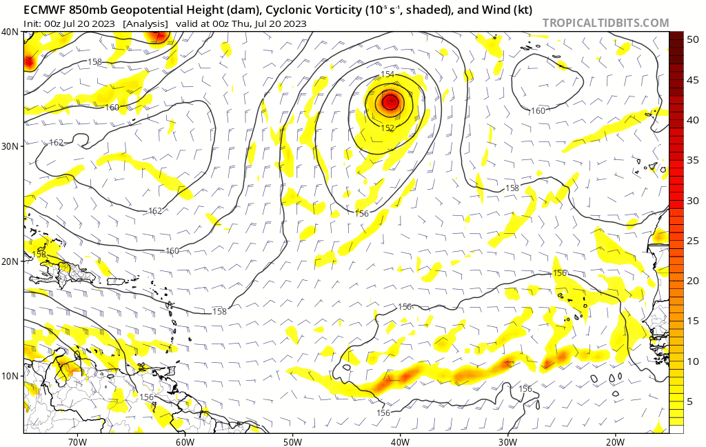
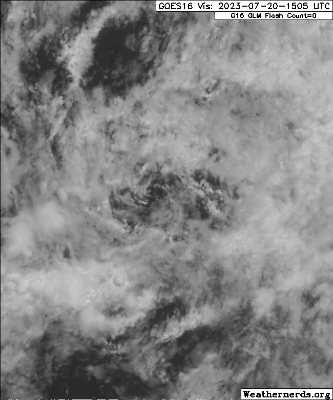
11N-38W looks interesting.

Zoom.

Zoom.
7 likes
Visit the Caribbean-Central America Weather Thread where you can find at first post web cams,radars
and observations from Caribbean basin members Click Here
and observations from Caribbean basin members Click Here
-
Blown Away

- S2K Supporter

- Posts: 9863
- Joined: Wed May 26, 2004 6:17 am
Re: Tropical Wave SW of Cabo Verde
cycloneye wrote:11N-38W looks interesting.
https://i.imgur.com/bLi877E.gif
Zoom.
https://i.imgur.com/mlFtt3z.gif
Nice find Luis! This spot is where the models see the low tightening up and then struggle with the low bouncing N and S which results in inconsistent solutions down the road. If this LLC can establish itself now I think the models will begin to show consistent solutions down the road. JMHO
1 likes
Hurricane Eye Experience: David 79, Irene 99, Frances 04, Jeanne 04, Wilma 05...
Hurricane Brush Experience: Andrew 92, Erin 95, Floyd 99, Matthew 16, Irma 17, Ian 22, Nicole 22…
Hurricane Brush Experience: Andrew 92, Erin 95, Floyd 99, Matthew 16, Irma 17, Ian 22, Nicole 22…

Re: Tropical Wave SW of Cabo Verde
cycloneye wrote:11N-38W looks interesting.
https://i.imgur.com/bLi877E.gif
Zoom.
https://i.imgur.com/mlFtt3z.gif

Definitely interesting. ASCAT shows a closed circulation with wind 25kt!
6 likes
-
cycloneye
- Admin
- Posts: 139090
- Age: 67
- Joined: Thu Oct 10, 2002 10:54 am
- Location: San Juan, Puerto Rico
Re: Tropical Wave SW of Cabo Verde
zzzh wrote:cycloneye wrote:11N-38W looks interesting.
https://i.imgur.com/bLi877E.gif
Zoom.
https://i.imgur.com/mlFtt3z.gif
https://i.imgur.com/y5w5cVl.png
Definitely interesting. ASCAT shows a closed circulation with wind 25kt!
Bingo!
2 likes
Visit the Caribbean-Central America Weather Thread where you can find at first post web cams,radars
and observations from Caribbean basin members Click Here
and observations from Caribbean basin members Click Here


Re: Tropical Wave SW of Cabo Verde
For the past several runs, the GFS has insisted on keeping the current weak low pressure that we've flagged in the same general area for 48+ hours. How feasible is this in reality? It definitely seems like there is a minor component of forward motion with the current disturbance.
0 likes
-
Hurricane2022

- Category 4

- Posts: 921
- Joined: Tue Aug 23, 2022 11:38 pm
- Location: Araçatuba, Brazil
Re: Tropical Wave SW of Cabo Verde
zzzh wrote:cycloneye wrote:11N-38W looks interesting.
https://i.imgur.com/bLi877E.gif
Zoom.
https://i.imgur.com/mlFtt3z.gif
https://i.imgur.com/y5w5cVl.png
Definitely interesting. ASCAT shows a closed circulation with wind 25kt!
Tropical Depression!!! Season is not cancelled!!
1 likes
Sorry for the bad English sometimes...!
For reliable and detailed information for any meteorological phenomenon, please consult the National Hurricane Center, Joint Typhoon Warning Center , or your local Meteo Center.
--------
Una cvm Christo, pro Christo, et in Christo. Sit nomen Domini benedictvm.
For reliable and detailed information for any meteorological phenomenon, please consult the National Hurricane Center, Joint Typhoon Warning Center , or your local Meteo Center.
--------
Una cvm Christo, pro Christo, et in Christo. Sit nomen Domini benedictvm.
Re: Tropical Wave SW of Cabo Verde
cycloneye wrote:zzzh wrote:cycloneye wrote:11N-38W looks interesting.
https://i.imgur.com/bLi877E.gif
Zoom.
https://i.imgur.com/mlFtt3z.gif
https://i.imgur.com/y5w5cVl.png
Definitely interesting. ASCAT shows a closed circulation with wind 25kt!
Bingo!
I imagine both the 2-day and 7-day probabilities for cyclogenesis will be increased a bit in the next TWO. (Perhaps 10% and 30% respectively.)
1 likes
-
cycloneye
- Admin
- Posts: 139090
- Age: 67
- Joined: Thu Oct 10, 2002 10:54 am
- Location: San Juan, Puerto Rico
Re: Tropical Wave SW of Cabo Verde
The circulation is moving eastward as the models are showing along the Monsoon trough for a while but then,it begins to move west.

8 likes
Visit the Caribbean-Central America Weather Thread where you can find at first post web cams,radars
and observations from Caribbean basin members Click Here
and observations from Caribbean basin members Click Here
Re: Tropical Wave SW of Cabo Verde
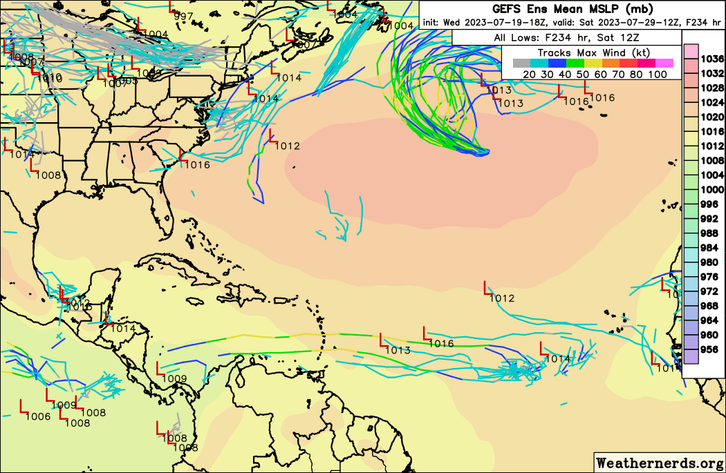
The 12Z GEFS is by a good margin the most active GEFS with this in the last two days of runs with ~3 H.
1 likes
Personal Forecast Disclaimer:
The posts in this forum are NOT official forecasts and should not be used as such. They are just the opinion of the poster and may or may not be backed by sound meteorological data. They are NOT endorsed by any professional institution or storm2k.org. For official information, please refer to the NHC and NWS products.
The posts in this forum are NOT official forecasts and should not be used as such. They are just the opinion of the poster and may or may not be backed by sound meteorological data. They are NOT endorsed by any professional institution or storm2k.org. For official information, please refer to the NHC and NWS products.
-
cycloneye
- Admin
- Posts: 139090
- Age: 67
- Joined: Thu Oct 10, 2002 10:54 am
- Location: San Juan, Puerto Rico
Re: Tropical Wave SW of Cabo Verde
Tropical Weather Outlook
NWS National Hurricane Center Miami FL
200 PM EDT Thu Jul 20 2023
For the North Atlantic...Caribbean Sea and the Gulf of Mexico:
Active Systems:
The National Hurricane Center is issuing advisories on Tropical
Storm Don, located over the central Atlantic.
Eastern Tropical Atlantic:
A tropical wave located a few hundred miles southwest of the Cabo
Verde Islands is currently interacting with the Intertropical
Convergence Zone. The combination of these features is producing an
elongated area of showers and thunderstorms over the eastern
and central tropical Atlantic. While dry air to the north may
prevent significant organization during the day or two,
environmental conditions could become more conducive for some
development later this weekend as the system moves westward across
the central tropical Atlantic.
* Formation chance through 48 hours...low...near 0 percent.
* Formation chance through 7 days...low...20 percent.
$$
Forecaster Brown

2 likes
Visit the Caribbean-Central America Weather Thread where you can find at first post web cams,radars
and observations from Caribbean basin members Click Here
and observations from Caribbean basin members Click Here
Re: Tropical Wave SW of Cabo Verde
zzzh wrote:cycloneye wrote:11N-38W looks interesting.
https://i.imgur.com/bLi877E.gif
Zoom.
https://i.imgur.com/mlFtt3z.gif
https://i.imgur.com/y5w5cVl.png
Definitely interesting. ASCAT shows a closed circulation with wind 25kt!
Luis and zzzh are focusing on what looks to me like a clearcut circulation based on satellite loops and ASCAT, which is near 11N, 38-39W. However, the NHC has (as shown by the TWO posted just above this) the yellow "X" near 11N, 30W (right or wrong, NHC is not focusing on the same specific area):
https://www.nhc.noaa.gov/gtwo.php?basin=atlc&fdays=2
2 likes
Personal Forecast Disclaimer:
The posts in this forum are NOT official forecasts and should not be used as such. They are just the opinion of the poster and may or may not be backed by sound meteorological data. They are NOT endorsed by any professional institution or storm2k.org. For official information, please refer to the NHC and NWS products.
The posts in this forum are NOT official forecasts and should not be used as such. They are just the opinion of the poster and may or may not be backed by sound meteorological data. They are NOT endorsed by any professional institution or storm2k.org. For official information, please refer to the NHC and NWS products.
Re: Tropical Wave SW of Cabo Verde
LarryWx wrote:zzzh wrote:cycloneye wrote:11N-38W looks interesting.
https://i.imgur.com/bLi877E.gif
Zoom.
https://i.imgur.com/mlFtt3z.gif
https://i.imgur.com/y5w5cVl.png
Definitely interesting. ASCAT shows a closed circulation with wind 25kt!
Luis and zzzh are focusing on what looks to me like a clearcut circulation based on satellite loops and ASCAT, which is near 11N, 38-39W. However, the NHC has (as shown by the TWO posted just above this) the yellow "X" near 11N, 30W (right or wrong, NHC is not focusing on the same specific area):
https://www.nhc.noaa.gov/gtwo.php?basin=atlc&fdays=2
All the models that do develop this show the circulation at 38W consolidating as well.
Meanwhile, the circ is now covered by a tiny bit of convection:
4 likes
Re: Tropical Wave SW of Cabo Verde
Teban54 wrote:LarryWx wrote:zzzh wrote:https://i.imgur.com/y5w5cVl.png
Definitely interesting. ASCAT shows a closed circulation with wind 25kt!
Luis and zzzh are focusing on what looks to me like a clearcut circulation based on satellite loops and ASCAT, which is near 11N, 38-39W. However, the NHC has (as shown by the TWO posted just above this) the yellow "X" near 11N, 30W (right or wrong, NHC is not focusing on the same specific area):
https://www.nhc.noaa.gov/gtwo.php?basin=atlc&fdays=2
All the models that do develop this show the circulation at 38W consolidating as well.
Meanwhile, the circ is now covered by a tiny bit of convection:
https://i.postimg.cc/zG2stLhV/90088070.gif
The models are kind of unusual with how they develop this. As Luis said and you seem to be implying, the LLC now near 38W retrogrades a little E over the next 24 hours while energy from a AEW now near 30W moves W and reaches the LLC tomorrow. They sort of collide. That must be why the yellow "X" in the TWO is at 30W. It is on the AEW rather than on the LLC. Then some models develop the LLC more.
The AEW now near 30W is mentioned in the latest TWD:
...TROPICAL WAVES...
A far eastern Atlantic tropical wave is west of the Cabo Verde Islands with its axis stretching from near 19N28W to 05N31W. It is moving westward around 10 kt. Scattered moderate convection is within 60 nm east of the wave from 07N to 10N.
3 likes
Personal Forecast Disclaimer:
The posts in this forum are NOT official forecasts and should not be used as such. They are just the opinion of the poster and may or may not be backed by sound meteorological data. They are NOT endorsed by any professional institution or storm2k.org. For official information, please refer to the NHC and NWS products.
The posts in this forum are NOT official forecasts and should not be used as such. They are just the opinion of the poster and may or may not be backed by sound meteorological data. They are NOT endorsed by any professional institution or storm2k.org. For official information, please refer to the NHC and NWS products.
-
Monsoonjr99
- Tropical Storm

- Posts: 208
- Age: 24
- Joined: Fri Sep 21, 2018 11:22 pm
- Location: Inland Empire, SoCal
Re: Tropical Wave south of Cabo Verde
Category5Kaiju wrote:tiger_deF wrote:While I am expecting this system or the moisture associated with it to go south of the greater Antilles, the modelled environment in the open Atlantic north of the islands is quite problematic. If the wave develops early and sneaks up there, it will have a fantastic upper-air environment and anomalously warm waters + OHC. The GFS runs that moved a developed system North of the islands bombed it out into an intense (and quite large) hurricane. As long as this scenario is avoided, I think that it will be shredded by the graveyard as modelled.
While extremely unlikely in this case, we saw this scenario happen in real time back in 2019, when a certain storm did that and became a very destructive Category 5 hurricane.
Thankfully this time around it is July rather than August, thus such a scenario being so unlikely.
0 likes
The posts in this forum are NOT official forecasts and should not be used as such. They are just the opinion of the poster and may or may not be backed by sound meteorological data. They are NOT endorsed by any professional institution or STORM2K. For official information, please refer to products from the NHC and NWS.
Some Californian who codes things and tracks weather.
Kay '22, Hilary '23
Re: Tropical Wave SW of Cabo Verde
Well, the 12 Euro ensembles has a nasty member with a cat4 heading right for Dade County after going over Haiti and bombs out over the hot waters in the Bahamas.
https://www.weathernerds.org/models/ece ... latlon=Off
https://www.weathernerds.org/models/ece ... latlon=Off
0 likes
Who is online
Users browsing this forum: Google [Bot], Ian2401, Kat5, LarryWx, pavelbure224 and 207 guests