Tropical Wave over the Central Atlantic (Is Invest 96L)
Moderator: S2k Moderators
Forum rules

The posts in this forum are NOT official forecasts and should not be used as such. They are just the opinion of the poster and may or may not be backed by sound meteorological data. They are NOT endorsed by any professional institution or STORM2K. For official information, please refer to products from the National Hurricane Center and National Weather Service.
-
wxman57

- Moderator-Pro Met

- Posts: 22482
- Age: 66
- Joined: Sat Jun 21, 2003 8:06 pm
- Location: Houston, TX (southwest)
Re: Tropical Wave SW of the Cabo Verde Islands
All models indicate a deep 500mb trof off the east coast next week. Such a pattern is NOT favorable for any U.S. impact from this wave. It's heading north and out to sea, most likely as a wave or weak low. Don't believe the GFS...
4 likes
-
Iceresistance

- Category 5

- Posts: 8915
- Age: 20
- Joined: Sat Oct 10, 2020 9:45 am
- Location: Tecumseh, OK/Norman, OK
Re: Tropical Wave SW of the Cabo Verde Islands
wxman57 wrote:All models indicate a deep 500mb trof off the east coast next week. Such a pattern is NOT favorable for any U.S. impact from this wave. It's heading north and out to sea, most likely as a wave or weak low. Don't believe the GFS...
There could be US impact from Storm Surge flooding if the GFS verifies even if there is no direct impact.
0 likes
Bill 2015 & Beta 2020
Winter 2020-2021
All observations are in Tecumseh, OK unless otherwise noted.
Winter posts are focused mainly for Oklahoma & Texas.
Take any of my forecasts with a grain of salt, refer to the NWS, SPC, and NHC for official information
Never say Never with weather! Because ANYTHING is possible!
Winter 2020-2021
All observations are in Tecumseh, OK unless otherwise noted.
Winter posts are focused mainly for Oklahoma & Texas.
Take any of my forecasts with a grain of salt, refer to the NWS, SPC, and NHC for official information
Never say Never with weather! Because ANYTHING is possible!
-
jconsor
- Professional-Met

- Posts: 532
- Joined: Mon Jun 30, 2008 9:31 pm
- Location: Jerusalem, Israel
- Contact:
Re: Tropical Wave SW of the Cabo Verde Islands
I think the E. Atlantic system has a decent chance for development (I would say 50-60% within 7 days). Don't be fooled by recency bias just because 95L encounted hostile conditions and didn't develop. The atmospheric state has changed substantially in a way that favors development more for this wave than it did for 95L.
https://twitter.com/yconsor/status/1684209439560065024
https://twitter.com/yconsor/status/1684214808713854978
https://twitter.com/yconsor/status/1684216357624111106
https://twitter.com/yconsor/status/1684222588279480322
https://twitter.com/yconsor/status/1684224928583761920
https://twitter.com/yconsor/status/1684209439560065024
https://twitter.com/yconsor/status/1684214808713854978
https://twitter.com/yconsor/status/1684216357624111106
https://twitter.com/yconsor/status/1684222588279480322
https://twitter.com/yconsor/status/1684224928583761920
6 likes

Re: Tropical Wave SW of the Cabo Verde Islands
The 12Z CMC is by far its strongest run yet with an H to the E of Bermuda. This would make 2 storms for July, which would make it above average for all seasons and the 2nd most active July for any El Niño season since 1982.
3 likes
Personal Forecast Disclaimer:
The posts in this forum are NOT official forecasts and should not be used as such. They are just the opinion of the poster and may or may not be backed by sound meteorological data. They are NOT endorsed by any professional institution or storm2k.org. For official information, please refer to the NHC and NWS products.
The posts in this forum are NOT official forecasts and should not be used as such. They are just the opinion of the poster and may or may not be backed by sound meteorological data. They are NOT endorsed by any professional institution or storm2k.org. For official information, please refer to the NHC and NWS products.
-
gatorcane

- S2K Supporter

- Posts: 23499
- Age: 46
- Joined: Sun Mar 13, 2005 3:54 pm
- Location: Boca Raton, FL
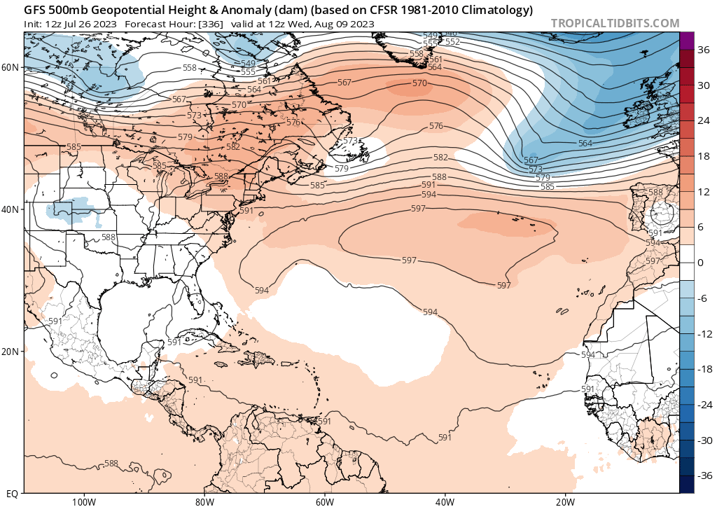
Re: Tropical Wave SW of the Cabo Verde Islands
wxman57 wrote:All models indicate a deep 500mb trof off the east coast next week. Such a pattern is NOT favorable for any U.S. impact from this wave. It's heading north and out to sea, most likely as a wave or weak low. Don't believe the GFS...
Yep even if it stays weak, the strong trough would turn it out to sea. Maybe a Bermuda threat. GFS 500MB below

2 likes
-
SFLcane

- S2K Supporter
- Posts: 9606
- Age: 46
- Joined: Sat Jun 05, 2010 1:44 pm
- Location: Lake Worth Florida
Re: Tropical Wave SW of the Cabo Verde Islands
gatorcane wrote:wxman57 wrote:All models indicate a deep 500mb trof off the east coast next week. Such a pattern is NOT favorable for any U.S. impact from this wave. It's heading north and out to sea, most likely as a wave or weak low. Don't believe the GFS...
Yep even if it stays weak, the strong trough would turn it out to sea. Maybe a Bermuda threat. GFS 500MB below
https://i.postimg.cc/9QHvFbM1/gfs-z500a-Norm-atl-24.png
Huge December like trof..

0 likes
-
Kingarabian

- S2K Supporter
- Posts: 15435
- Joined: Sat Aug 08, 2009 3:06 am
- Location: Honolulu, Hawaii
Re: Tropical Wave SW of the Cabo Verde Islands
wxman57 wrote:All models indicate a deep 500mb trof off the east coast next week. Such a pattern is NOT favorable for any U.S. impact from this wave. It's heading north and out to sea, most likely as a wave or weak low. Don't believe the GFS...
CMC now develops it.
1 likes
RIP Kobe Bryant
Re: Tropical Wave SW of the Cabo Verde Islands
Kingarabian wrote:wxman57 wrote:All models indicate a deep 500mb trof off the east coast next week. Such a pattern is NOT favorable for any U.S. impact from this wave. It's heading north and out to sea, most likely as a wave or weak low. Don't believe the GFS...
CMC now develops it.
I expect a TWO later today and possibly as early as the one soon to be released to be upgraded from lemon to orange for the 7 day.
Based on the GFS/CMC, this would be a July TCG and would make two NS this month. I just checked El Niño seasons even further back than 1982. If this month reaches two storms, it would tie it with 1979, 1887, and 1864 for the 2nd highest # of July storms during the 54 El Niño seasons since 1851 either then present or coming later that season. Only 1997 would be more active with its three storms that formed in July.
2 likes
Personal Forecast Disclaimer:
The posts in this forum are NOT official forecasts and should not be used as such. They are just the opinion of the poster and may or may not be backed by sound meteorological data. They are NOT endorsed by any professional institution or storm2k.org. For official information, please refer to the NHC and NWS products.
The posts in this forum are NOT official forecasts and should not be used as such. They are just the opinion of the poster and may or may not be backed by sound meteorological data. They are NOT endorsed by any professional institution or storm2k.org. For official information, please refer to the NHC and NWS products.
-
Spacecoast

- Category 2

- Posts: 687
- Joined: Thu Aug 31, 2017 2:03 pm
Re: Tropical Wave SW of the Cabo Verde Islands
gatorcane wrote:wxman57 wrote:All models indicate a deep 500mb trof off the east coast next week. Such a pattern is NOT favorable for any U.S. impact from this wave. It's heading north and out to sea, most likely as a wave or weak low. Don't believe the GFS...
Yep even if it stays weak, the strong trough would turn it out to sea. Maybe a Bermuda threat. GFS 500MB below
https://i.postimg.cc/9QHvFbM1/gfs-z500a-Norm-atl-24.png
12z GEFS trough prob....

2 likes
-
cycloneye

- Admin

- Posts: 139089
- Age: 67
- Joined: Thu Oct 10, 2002 10:54 am
- Location: San Juan, Puerto Rico
Re: Tropical Wave SW of the Cabo Verde Islands
2 PM TWO:
Tropical Weather Outlook
NWS National Hurricane Center Miami FL
200 PM EDT Wed Jul 26 2023
For the North Atlantic...Caribbean Sea and the Gulf of Mexico:
Eastern Atlantic:
A tropical wave is located a couple of hundred miles to the
southwest of the Cabo Verde Islands. Conditions are expected to be
favorable for gradual development of this system later this week and
into the weekend while it moves westward to west-northwestward over
the tropical Atlantic.
* Formation chance through 48 hours...low...near 0 percent.
* Formation chance through 7 days...low...30 percent.
$$
Forecaster Pasch
1 likes
Visit the Caribbean-Central America Weather Thread where you can find at first post web cams,radars
and observations from Caribbean basin members Click Here
and observations from Caribbean basin members Click Here
-
Kingarabian
- S2K Supporter
- Posts: 15435
- Joined: Sat Aug 08, 2009 3:06 am
- Location: Honolulu, Hawaii
Re: Tropical Wave SW of the Cabo Verde Islands
Spacecoast wrote:gatorcane wrote:wxman57 wrote:All models indicate a deep 500mb trof off the east coast next week. Such a pattern is NOT favorable for any U.S. impact from this wave. It's heading north and out to sea, most likely as a wave or weak low. Don't believe the GFS...
Yep even if it stays weak, the strong trough would turn it out to sea. Maybe a Bermuda threat. GFS 500MB below
https://i.postimg.cc/9QHvFbM1/gfs-z500a-Norm-atl-24.png
12z GEFS trough prob....
https://i.ibb.co/ZW1VPVF/ed28.jpg
Nice plot. Essentially a 50% chance of a trough.
0 likes
RIP Kobe Bryant
-
cycloneye
- Admin
- Posts: 139089
- Age: 67
- Joined: Thu Oct 10, 2002 10:54 am
- Location: San Juan, Puerto Rico
Re: Tropical Wave SW of the Cabo Verde Islands
1 likes
Visit the Caribbean-Central America Weather Thread where you can find at first post web cams,radars
and observations from Caribbean basin members Click Here
and observations from Caribbean basin members Click Here
Re: Tropical Wave SW of the Cabo Verde Islands
The 12Z Euro is by a good margin (a TD it appears) the strongest with this of any of its runs to date. It is also E of Bermuda.
0 likes
Personal Forecast Disclaimer:
The posts in this forum are NOT official forecasts and should not be used as such. They are just the opinion of the poster and may or may not be backed by sound meteorological data. They are NOT endorsed by any professional institution or storm2k.org. For official information, please refer to the NHC and NWS products.
The posts in this forum are NOT official forecasts and should not be used as such. They are just the opinion of the poster and may or may not be backed by sound meteorological data. They are NOT endorsed by any professional institution or storm2k.org. For official information, please refer to the NHC and NWS products.
-
jlauderdal
- S2K Supporter
- Posts: 6771
- Joined: Wed May 19, 2004 5:46 am
- Location: NE Fort Lauderdale
- Contact:
Re: Tropical Wave SW of the Cabo Verde Islands
LarryWx wrote:The 12Z Euro is by a good margin (a TD it appears) the strongest with this of any of its runs to date. It is also E of Bermuda.
Good News on the troughing, its been dominant this season so far. The ridge is building back in the next few days in Florida which has been rare this rainy season.
2 likes
-
SFLcane
- S2K Supporter
- Posts: 9606
- Age: 46
- Joined: Sat Jun 05, 2010 1:44 pm
- Location: Lake Worth Florida
Re: Tropical Wave SW of the Cabo Verde Islands
jlauderdal wrote:LarryWx wrote:The 12Z Euro is by a good margin (a TD it appears) the strongest with this of any of its runs to date. It is also E of Bermuda.
Good News on the troughing, its been dominant this season so far. The ridge is building back in the next few days in Florida which has been rare this rainy season.
Better not be any hurricanes around if not we are going to have some problems.

1 likes


-
Kingarabian
- S2K Supporter
- Posts: 15435
- Joined: Sat Aug 08, 2009 3:06 am
- Location: Honolulu, Hawaii
Re: Tropical Wave SW of the Cabo Verde Islands
I would say development chances are above 50%.
2 likes
RIP Kobe Bryant

Re: Tropical Wave SW of the Cabo Verde Islands
Kingarabian wrote:Spacecoast wrote:gatorcane wrote:
Yep even if it stays weak, the strong trough would turn it out to sea. Maybe a Bermuda threat. GFS 500MB below
https://i.postimg.cc/9QHvFbM1/gfs-z500a-Norm-atl-24.png
12z GEFS trough prob....
https://i.ibb.co/ZW1VPVF/ed28.jpg
Nice plot. Essentially a 50% chance of a trough.
50% as far south as North Carolina.
Unless there is a hurricane north of the Bahamas in which case any short wave might dig.
And since as you noted the chance of development is only about 50%..
Will be an interesting week since there is more moisture projected to be in place along the track.
0 likes
-
Blown Away

- S2K Supporter
- Posts: 9863
- Joined: Wed May 26, 2004 6:17 am
Re: Tropical Wave SW of the Cabo Verde Islands
18z GFS, turns NE @25N/60W. Pretty aggressive turn to NE at that low latitude.
0 likes
Hurricane Eye Experience: David 79, Irene 99, Frances 04, Jeanne 04, Wilma 05...
Hurricane Brush Experience: Andrew 92, Erin 95, Floyd 99, Matthew 16, Irma 17, Ian 22, Nicole 22…
Hurricane Brush Experience: Andrew 92, Erin 95, Floyd 99, Matthew 16, Irma 17, Ian 22, Nicole 22…