Weak Low Inland Over SE Georgia (Is Invest 97L)
Moderator: S2k Moderators
Forum rules

The posts in this forum are NOT official forecasts and should not be used as such. They are just the opinion of the poster and may or may not be backed by sound meteorological data. They are NOT endorsed by any professional institution or STORM2K. For official information, please refer to products from the National Hurricane Center and National Weather Service.
-
hurricanedude

- Military Member

- Posts: 1856
- Joined: Tue Oct 08, 2002 9:54 am
- Location: Virginia Beach, Virginia
- Contact:
Weak Low Inland Over SE Georgia (Is Invest 97L)
JB on his twitter is concerned about the area of convection near the Bahamas. He mentions regardless of model support it has a shot of becoming something. Thoughts?
1 likes
-
wxman57

- Moderator-Pro Met

- Posts: 22482
- Age: 66
- Joined: Sat Jun 21, 2003 8:06 pm
- Location: Houston, TX (southwest)
Re: Weak Surface Trough Over the Bahamas
hurricanedude wrote:JB on his twitter is concerned about the area of convection near the Bahamas. He mentions regardless of model support it has a shot of becoming something. Thoughts?
It's not significant. A little rain for north Florida and southern Georgia Fri/Sat, but that's it.
0 likes

Re: Weak Surface Trough Over the Bahamas
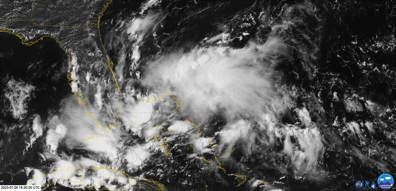
Looks to be disorganised but that a lot of convection that's due to head across Florida into the gulf.
1 likes
Re: Weak Surface Trough Over the Bahamas
ChrisH-UK wrote:Looks to be disorganised but that a lot of convection that's due to head across Florida into the gulf.
[url]https://imagizer.imageshack.com/img924/5024/QluHod.gif [/url]
Part of this convection near S FL/Keys lead to a large increase in rainfall and decrease in sunshine (finally) that lead to those buoys with upper 90s to 101F highs just two days ago to plunge to only the 80s for daytime highs today!
2 likes
Personal Forecast Disclaimer:
The posts in this forum are NOT official forecasts and should not be used as such. They are just the opinion of the poster and may or may not be backed by sound meteorological data. They are NOT endorsed by any professional institution or storm2k.org. For official information, please refer to the NHC and NWS products.
The posts in this forum are NOT official forecasts and should not be used as such. They are just the opinion of the poster and may or may not be backed by sound meteorological data. They are NOT endorsed by any professional institution or storm2k.org. For official information, please refer to the NHC and NWS products.
-
toad strangler

- S2K Supporter

- Posts: 4162
- Joined: Sun Jul 28, 2013 3:09 pm
- Location: Earth
- Contact:
Re: Weak Surface Trough Over the Bahamas
The Space and Treasure Coasts are in line for some heavy showers today and this evening thanks to this weak tropical wave as are other areas on the peninsula I'm sure.
From the morning forecast disco out of NWS MLB ...
Today-Tonight...The tropical wave will continue to traverse the
south-central FL peninsula as PWATs surge to 2.10-2.40 inches over
most of ECFL. Some locally heavy rainfall will be possible today,
especially Space/Treasure coasts, with locally heavy rainfall also
possible later today into Okeechobee/Osceola counties. Some
fairly high amounts for areas that receive multiple rounds of
showery precip and localized 1-3" amounts are not out of the
question, with a location or two up to 4 inches.
Last edited by toad strangler on Thu Jul 27, 2023 7:11 am, edited 1 time in total.
0 likes

Re: Weak Surface Trough Over the Bahamas
Been watching this area for the past few days, a weak surface vortex is now evident on radar, sat & surface observations east of Melbourne/Vero Beach area but should move inland later today or tonight before organizing much further, which is a good thing because it is in an area of low windshear in between two ULLs.
3 likes
-
MGC

- S2K Supporter
- Posts: 5792
- Joined: Sun Mar 23, 2003 9:05 pm
- Location: Pass Christian MS, or what is left.
Re: Weak Surface Trough Over the Bahamas
Looks like a sharp trough to me. Will be inland soon. Maybe something could spin-up in the Gulf later. We could use some rain here on the Miss Coast......MGC
1 likes
Re: Weak Surface Trough Over the Bahamas
It is interesting how much cooling of the previously extremely warm shallow water SSTs just south of the FL peninsula resulted from just a weak surface trough since Monday. For example: Johnson Key buoy, which hit 98.2F for Monday's high, was down to only 79.3F for this morning's low SST! See it here for yourself:
https://www.ndbc.noaa.gov/show_plot.php ... &meas=wtmp
https://www.ndbc.noaa.gov/show_plot.php ... &meas=wtmp
1 likes
Personal Forecast Disclaimer:
The posts in this forum are NOT official forecasts and should not be used as such. They are just the opinion of the poster and may or may not be backed by sound meteorological data. They are NOT endorsed by any professional institution or storm2k.org. For official information, please refer to the NHC and NWS products.
The posts in this forum are NOT official forecasts and should not be used as such. They are just the opinion of the poster and may or may not be backed by sound meteorological data. They are NOT endorsed by any professional institution or storm2k.org. For official information, please refer to the NHC and NWS products.

Re: Weak Surface Trough Over the Bahamas
LarryWx wrote:It is interesting how much cooling of the previously extremely warm shallow water SSTs just south of the FL peninsula resulted from just a weak surface trough since Monday. For example: Johnson Key buoy, which hit 98.2F for Monday's high, was down to only 79.3F for this morning's low SST! See it here for yourself:
https://www.ndbc.noaa.gov/show_plot.php ... &meas=wtmp
This is a great relief. Hopefully we get more of these troughs/waves to cool of the water.
This is a shallow water spot. Unfortunately the water near Key West is still around 90°
1 likes
-
tropicwatch

- Category 5

- Posts: 3205
- Age: 60
- Joined: Sat Jun 02, 2007 10:01 am
- Location: Panama City Florida
- Contact:
Re: Weak Surface Trough Over the Bahamas
Not much at the surface, the 925mb and 850mb vorticity not showing much at all.
0 likes
Tropicwatch
Agnes 72', Eloise 75, Elena 85', Kate 85', Charley 86', Florence 88', Beryl 94', Dean 95', Erin 95', Opal 95', Earl 98', Georges 98', Ivan 2004', Arlene 2005', Dennis 2005', Ida 2009' Debby 2012' Irma 2017' Michael 2018'
Agnes 72', Eloise 75, Elena 85', Kate 85', Charley 86', Florence 88', Beryl 94', Dean 95', Erin 95', Opal 95', Earl 98', Georges 98', Ivan 2004', Arlene 2005', Dennis 2005', Ida 2009' Debby 2012' Irma 2017' Michael 2018'
Re: Weak Surface Trough Over the Bahamas
Almost looks like a depression on radar, however the pressure is too high and the winds are nowhere close to supporting this as a system. The highest wind gust I saw was 29 knots, 21 knots sustained at the 20 mile buoy off Cape Canaveral (41009) a few hours ago.
This brings welcome relief to the hot summer for the east coast of Florida but likely will cause another scrub for the Falcon 9 Heavy that is scheduled to launch around 11pm tonight.
This brings welcome relief to the hot summer for the east coast of Florida but likely will cause another scrub for the Falcon 9 Heavy that is scheduled to launch around 11pm tonight.
1 likes
-
jconsor
- Professional-Met

- Posts: 532
- Joined: Mon Jun 30, 2008 9:31 pm
- Location: Jerusalem, Israel
- Contact:
Re: Weak Surface Trough Over the Bahamas
Agreed that pressures are high and this will need some time to "cook" before developing, but it going just inland is not a guarantee against a TD or weak TS developing. We have seen such systems develop even with little model support a few times in the recent past.
There is another brief window for development early next week as it heads back offshore and passes near the Gulf Stream:
https://twitter.com/OSUWXGUY/status/1684657687206694913
https://twitter.com/OSUWXGUY/status/1684674411616456704
https://twitter.com/yconsor/status/1684677308148256769
https://twitter.com/yconsor/status/1684683453424435200
2 likes


Re: Weak Surface Trough Over the Bahamas
Landy wrote:Interesting appearance early this AM.
https://media.discordapp.net/attachments/877402829797621770/1134424923293622272/41793196.gif
There is a tight little circulation center (easily seen on radar) just offshore from Amelia Island where SSTs are ~85F moving NNW toward the lower GA coast, but it is more mid level than low level from what I've read. One NWS discussion mentioned that this is in association with the TUTT (see below). Surface pressures are still pretty high (1017 mb+) and surface winds are light. The highest wind I could find in gusts is 16 knots and that is at an offshore buoy.
From Jacksonville NWS office earlier this morning:
AT THE SURFACE, AN INVERTED TROUGH ACROSS NORTH CENTRAL FL
WILL LIFT NORTH-NORTHWESTWARD UP THE NE FL COAST AND INTO THE
ALTAMAHA RIVER BASIN BY THIS EVENING. MEANWHILE, A TROPICAL UPPER
TROPOSPHERIC TROUGH (TUTT) AND ASSOCIATED VORTICITY MAX WILL
ROTATE ACROSS THE AREA.
From Melbourne just minutes ago:
ISSUED AT 924 AM EDT FRI JUL 28 2023
IN THE WAKE OF THE DISTURBANCE THAT MOVED OVERHEAD YESTERDAY, DEEP
S/SE FLOW IS IN PLACE ACROSS MUCH OF THE FL PENINSULA THIS MORNING.
IN FACT, THAT FEATURE HAS ACTUALLY CLOSED OFF INTO A WEAK
SURFACE LOW NEAR JACKSONVILLE.
0 likes
Personal Forecast Disclaimer:
The posts in this forum are NOT official forecasts and should not be used as such. They are just the opinion of the poster and may or may not be backed by sound meteorological data. They are NOT endorsed by any professional institution or storm2k.org. For official information, please refer to the NHC and NWS products.
The posts in this forum are NOT official forecasts and should not be used as such. They are just the opinion of the poster and may or may not be backed by sound meteorological data. They are NOT endorsed by any professional institution or storm2k.org. For official information, please refer to the NHC and NWS products.
-
tolakram
- Admin

- Posts: 19165
- Age: 60
- Joined: Sun Aug 27, 2006 8:23 pm
- Location: Florence, KY (name is Mark)
Re: Weak Surface Trough Over the Bahamas
4 likes
M a r k
- - - - -
Join us in chat: Storm2K Chatroom Invite. Android and IOS apps also available.
The posts in this forum are NOT official forecasts and should not be used as such. Posts are NOT endorsed by any professional institution or STORM2K.org. For official information and forecasts, please refer to NHC and NWS products.
-
Hurricane2022

- Category 4

- Posts: 923
- Joined: Tue Aug 23, 2022 11:38 pm
- Location: Araçatuba, Brazil
Re: Weak Surface Trough Over the Bahamas
3 likes
Sorry for the bad English sometimes...!
For reliable and detailed information for any meteorological phenomenon, please consult the National Hurricane Center, Joint Typhoon Warning Center , or your local Meteo Center.
--------
Una cvm Christo, pro Christo, et in Christo. Sit nomen Domini benedictvm.
For reliable and detailed information for any meteorological phenomenon, please consult the National Hurricane Center, Joint Typhoon Warning Center , or your local Meteo Center.
--------
Una cvm Christo, pro Christo, et in Christo. Sit nomen Domini benedictvm.
-
wxman57
- Moderator-Pro Met
- Posts: 22482
- Age: 66
- Joined: Sat Jun 21, 2003 8:06 pm
- Location: Houston, TX (southwest)
Re: Weak Low Moving Inland into SE Georgia
Just a weak swirl moving inland into SE Georgia now. Winds 10-15 kts.
1 likes
Weak Low Inland Over SE Georgia
If they're going to be close to me, I want them cute and weak! It is a very tropical looking sky here with lots of beautiful towering clouds along with stratiform clouds, occasional showers (no thunder), and high humidity. Without looking at a map, one would know that there's something unusual today. It is acting like a TC is nearby but with hardly any wind. Kind of cool to experience this without the danger that I don't want any part of.
2 likes
Personal Forecast Disclaimer:
The posts in this forum are NOT official forecasts and should not be used as such. They are just the opinion of the poster and may or may not be backed by sound meteorological data. They are NOT endorsed by any professional institution or storm2k.org. For official information, please refer to the NHC and NWS products.
The posts in this forum are NOT official forecasts and should not be used as such. They are just the opinion of the poster and may or may not be backed by sound meteorological data. They are NOT endorsed by any professional institution or storm2k.org. For official information, please refer to the NHC and NWS products.
-
tolakram
- Admin
- Posts: 19165
- Age: 60
- Joined: Sun Aug 27, 2006 8:23 pm
- Location: Florence, KY (name is Mark)
Re: Weak Low Inland Over SE Georgia
Still going.

GFS says it will go back over water tonight.

GFS says it will go back over water tonight.
1 likes
M a r k
- - - - -
Join us in chat: Storm2K Chatroom Invite. Android and IOS apps also available.
The posts in this forum are NOT official forecasts and should not be used as such. Posts are NOT endorsed by any professional institution or STORM2K.org. For official information and forecasts, please refer to NHC and NWS products.
- - - - -
Join us in chat: Storm2K Chatroom Invite. Android and IOS apps also available.
The posts in this forum are NOT official forecasts and should not be used as such. Posts are NOT endorsed by any professional institution or STORM2K.org. For official information and forecasts, please refer to NHC and NWS products.

Re: Weak Low Inland Over SE Georgia
Some model runs do develop this, most notably 0z Euro:
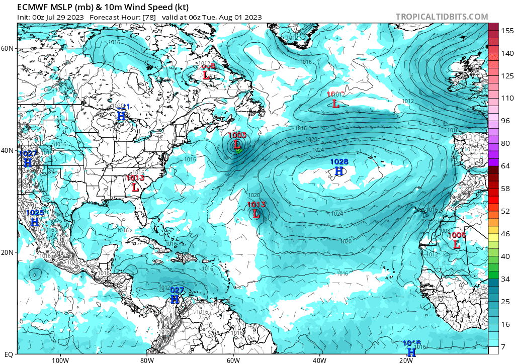
Even runs with no development seem to show the vorticity competing with 96L and thus limiting the latter's development.
Even runs with no development seem to show the vorticity competing with 96L and thus limiting the latter's development.
0 likes