
Low Pressure in the Northwest Caribbean Sea (Is Invest 93L)
Moderator: S2k Moderators
Forum rules

The posts in this forum are NOT official forecasts and should not be used as such. They are just the opinion of the poster and may or may not be backed by sound meteorological data. They are NOT endorsed by any professional institution or STORM2K. For official information, please refer to products from the National Hurricane Center and National Weather Service.
-
cycloneye

- Admin

- Posts: 139137
- Age: 67
- Joined: Thu Oct 10, 2002 10:54 am
- Location: San Juan, Puerto Rico
Low Pressure in the Northwest Caribbean Sea (Is Invest 93L)
2 likes
Visit the Caribbean-Central America Weather Thread where you can find at first post web cams,radars
and observations from Caribbean basin members Click Here
and observations from Caribbean basin members Click Here

Re: Possible Development in the Western Caribbean
cycloneye wrote:https://i.imgur.com/Pj5RZbA.gif
It looks like the area of energy models are picking up on is still in the Pacific and will be crossing over tomorrow afternoon into Friday morning. I think things will become a little clearer once it actually enters the Gulf
1 likes

Re: Possible Development in the Western Caribbean
cycloneye wrote:https://i.imgur.com/Pj5RZbA.gif
Clear spin there. Wonder if this will combine with energy from the Pacific and one big gyre from it. Seems it might form a bit more east though.
1 likes


Re: Possible Development in the Western Caribbean
I think the area the models are latching onto is just below El Salvador and Guatemala. On MIMIC you can see a good spin down there. I don't post a lot and hope I shared the image right.
5 likes
Re: Possible Development in the Western Caribbean
ICON 18z same as prior runs. It's the shorter 18z though but same general area as before. Weak TS end of run. 00z probably into SWFL again.
0 likes

Re: Possible Development in the Western Caribbean
Andy doesn't learn, still questioning the Euro despite how well it performed on forecasting Franklin to develop before the GFS.
In the short to medium range the Euro is King, I am sure the GFS will eventually trend towards the rest of the models.
https://twitter.com/AndyHazelton/status/1694467906447241613
In the short to medium range the Euro is King, I am sure the GFS will eventually trend towards the rest of the models.
https://twitter.com/AndyHazelton/status/1694467906447241613
1 likes
Re: Possible Development in the Western Caribbean
NDG wrote:Andy doesn't learn, still questioning the Euro despite how well it performed on forecasting Franklin to develop before the GFS.
In the short to medium range the Euro is King, I am sure the GFS will eventually trend towards the rest of the models.
https://twitter.com/AndyHazelton/status/1694467906447241613
18z gfs still shows it next wed, just sheared out once again
0 likes
Re: Possible Development in the Western Caribbean
Unfortunately if anything forms in the western Caribbean the protective stacked ridge will not be there next week to protect the SE US/FL.

2 likes
Re: Possible Development in the Western Caribbean
18z GFS shows even less vorticity than 12z on it. It'll be a toss up if the NHC puts it on the outlook.
1 likes
-
gatorcane

- S2K Supporter

- Posts: 23499
- Age: 46
- Joined: Sun Mar 13, 2005 3:54 pm
- Location: Boca Raton, FL
Re: Possible Development in the Western Caribbean
18Z GFS looks less defined than the 12Z as it moves through Western Cuba and the FL Straits. I can barely make out any vorticity. Note it starts in the EPAC and then crosses over:
Last edited by gatorcane on Wed Aug 23, 2023 5:25 pm, edited 1 time in total.
0 likes

Re: Possible Development in the Western Caribbean
Looks like the GFS does not buy into the crossover. Vorticity completely dies out once it hits the coast. Euro keeps the energy and survives. I would imagine there is going to be some vorticity cross over. Whether it develops is another story. We are going to find out pretty soon in the next 48hrs.
18z GFS

12Z Euro

12 CMC

18z GFS
12Z Euro
12 CMC
0 likes
The following post is NOT an official forecast and should not be used as such. It is just the opinion of the poster and may or may not be backed by sound meteorological data. It is NOT endorsed by any professional institution including storm2k.org For Official Information please refer to the NHC and NWS products.
-
weeniepatrol

- Category 3

- Posts: 857
- Joined: Sat Aug 22, 2020 5:30 pm
- Location: WA State
Re: Possible Development in the Western Caribbean
I would caution against taking genesis at face value from the models. They are struggling this year
0 likes
-
Spacecoast

- Category 2

- Posts: 687
- Joined: Thu Aug 31, 2017 2:03 pm
Re: Possible Development in the Western Caribbean
How often does EPAC - ATL crossovers occur? It seems rare. The only example I found was Unnamed 1902 which was further north over to Bay of Compeche.
0 likes
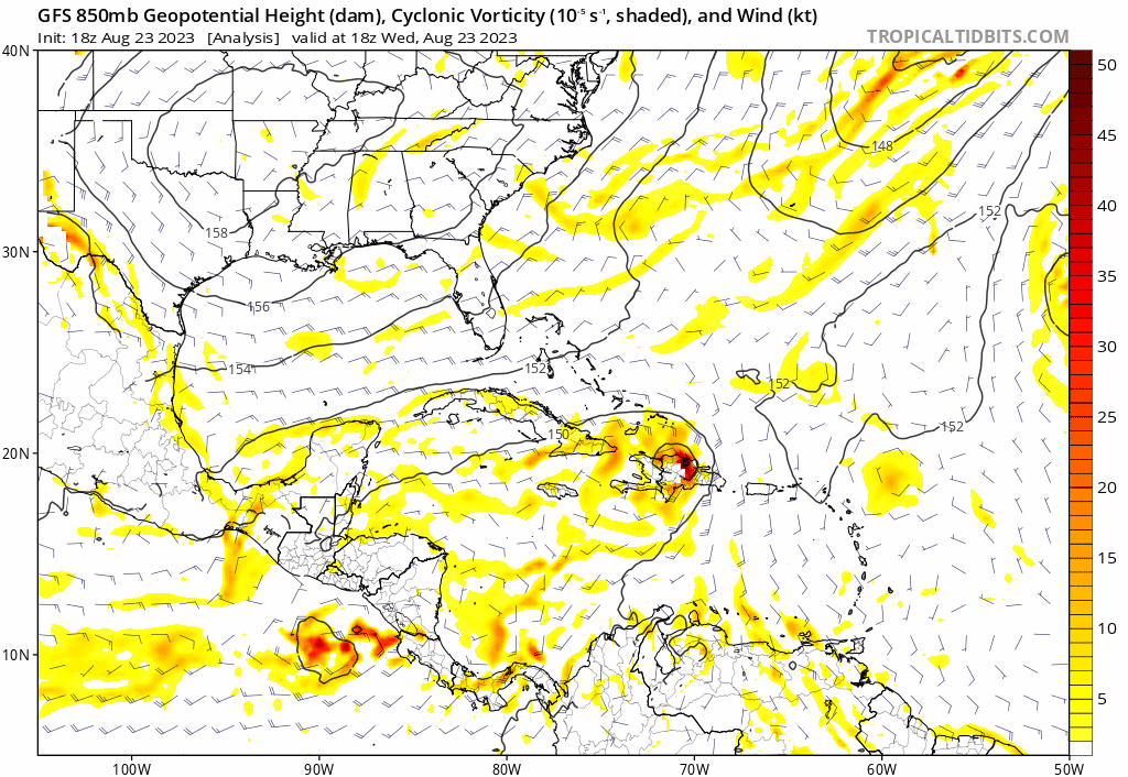
Re: Possible Development in the Western Caribbean
850mb Vorticity is pretty strong right now in that area.

4 likes
The following post is NOT an official forecast and should not be used as such. It is just the opinion of the poster and may or may not be backed by sound meteorological data. It is NOT endorsed by any professional institution including storm2k.org For Official Information please refer to the NHC and NWS products.
Re: Possible Development in the Western Caribbean
I think I figured out why the difference between the GFS and Euro.
The GFS builds in a narrow ridge below Franklin on the Caribbean Sea which pushes west faster pushing the vorticity coming out of the EPAC inland into Guatemala. At the same time it erodes the ridge along the Gulf Coast and the SE US and a messy system lifts north towards FL.
On the other hand the Euro keeps a narrow ridge in place along the gulf coast through this weekend, it also shows a narrow ridge below Franklin but does not to push it west that much thus the vorticity staying closer to Western Caribbean Sea for a longer time until the narrow ridge breaks down early next week.
2 likes
Re: Possible Development in the Western Caribbean
Spacecoast wrote:How often does EPAC - ATL crossovers occur? It seems rare. The only example I found was Unnamed 1902 which was further north over to Bay of Compeche.
It usually happens early in the season every so often years or late in the season as a messy sheared system, kind of unusual for this time of the year.
1 likes
-
chris_fit

- Category 5

- Posts: 3078
- Joined: Wed Sep 10, 2003 11:58 pm
- Location: Tampa Bay Area, FL
- Contact:
Re: Possible Development in the Western Caribbean
12Z EPS seem very active, maybe the most active run yet.
0 likes
Re: Possible Development in the Western Caribbean
Spacecoast wrote:How often does EPAC - ATL crossovers occur? It seems rare. The only example I found was Unnamed 1902 which was further north over to Bay of Compeche.
4 times as far as I know it's a really rare event.

1 likes
-
tolakram
- Admin
- Posts: 19165
- Age: 60
- Joined: Sun Aug 27, 2006 8:23 pm
- Location: Florence, KY (name is Mark)
Re: Possible Development in the Western Caribbean
This isn't a crossover though IMO, just an area of vorticity that may or may not spark a storm. This is almost a model storm, though there does seem to be a disturbance in the general area already. 7 days is 168 hours, will be interesting to see if the NHC bites at 8PM.
EURO 168

CMC 132

ICON 120

EURO 168
CMC 132
ICON 120
1 likes
M a r k
- - - - -
Join us in chat: Storm2K Chatroom Invite. Android and IOS apps also available.
The posts in this forum are NOT official forecasts and should not be used as such. Posts are NOT endorsed by any professional institution or STORM2K.org. For official information and forecasts, please refer to NHC and NWS products.
Re: Possible Development in the Western Caribbean
Amanda--Cristobal 2020 should be added to the list. Crossed over and made it all the way to the Midwest. The system had impressive endurance.
1 likes
Solar Aquarian
Lunar Cancerian
 Sagittarian
Lunar Cancerian
Who is online
Users browsing this forum: ouragans and 187 guests