

Low Pressure in the Northwest Caribbean Sea (Is Invest 93L)
Moderator: S2k Moderators
Forum rules

The posts in this forum are NOT official forecasts and should not be used as such. They are just the opinion of the poster and may or may not be backed by sound meteorological data. They are NOT endorsed by any professional institution or STORM2K. For official information, please refer to products from the National Hurricane Center and National Weather Service.
Re: Low Pressure in the Northwest Caribbean Sea
Very evident surface vorticity on vis sat this morning, but fairly broad at this time.
5 likes
-
Kingarabian

- S2K Supporter

- Posts: 15437
- Joined: Sat Aug 08, 2009 3:06 am
- Location: Honolulu, Hawaii
Re: Low Pressure in the Northwest Caribbean Sea
NDG wrote:06z Euro through 90 hrs, almost identical to its earlier 0z run.
https://i.imgur.com/AtOxpWl.gif
Looked a little slower vs the 12z.
1 likes
RIP Kobe Bryant
-
toad strangler

- S2K Supporter
- Posts: 4162
- Joined: Sun Jul 28, 2013 3:09 pm
- Location: Earth
- Contact:
Re: Low Pressure in the Northwest Caribbean Sea
Florida on Alert for Increasing Tropical Threat Next Week
Tropical system expected to form over Gulf waters and head toward Florida for early next week
MICHAEL LOWRY
AUG 25
A broad area of spin and storminess pivoting across Central America into the northwestern Caribbean today is forecast to slowly come together by this weekend near the Yucatán Channel and emerge over the eastern Gulf of Mexico early next week. The National Hurricane Center expects a tropical depression or storm to form in the coming days and move toward Florida from next Tuesday to Thursday.
While for now models don’t show a strong system approaching Florida, the unique setup in late August is one that could allow the system to overachieve and quickly strengthen more than currently advertised. Given the forecast potential, Floridians are encouraged to check back throughout the weekend for the latest information.
What to expect this weekend
The biggest short-term factor with the low-pressure area is how much entanglement with land disrupts early development. If the fledgling circulation tries to take shape over land – specifically Mexico’s Yucatán Peninsula – it will be a speed bump to formation this weekend. Models have been vacillating on exactly where the spin may try to consolidate, so our focus this weekend will be where and how quickly the system organizes. The current model consensus is for slower development over the weekend due to proximity to land.
Where it’s headed next week
Forecast models are in good agreement on the steering pattern for next week. A dip in the jet stream ushering in a cold front to the southeastern U.S. will pick up the system and steer it northeastward beginning on Monday and slingshotting it toward Florida’s Gulf coast by Tuesday through Wednesday. Of course, for a state like Florida with a slanted coastline, the fine details matter and as we’ve seen in recent years a slight deviation in approach angle can translate into a big difference in where a storm system comes ashore.
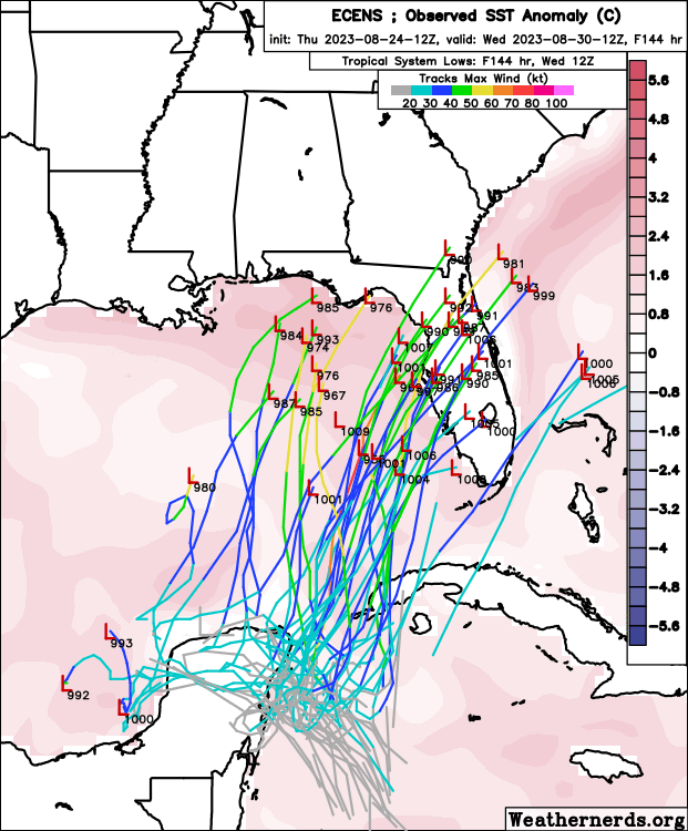
Low-pressure tracks from the overnight run of the European ensemble forecast system. A greater number of weak low-pressure tracks (shown in blue) are farther south, with stronger scenarios farther north. Credit: Weathernerds.org
Given the orientation of upper-level winds, a broader, weaker system would favor an approach farther south over the Florida peninsula. A more organized storm would lean farther north toward Florida’s Big Bend or eastern panhandle. In either case, the surge of tropical air and storminess will tilt largely east of the low pressure circulation, which means much of Florida will be affected by wet and unsettled weather through mid-week.
How strong will it get?
As we discussed in Thursday’s newsletter, an upper-level low sliding west of the system on Monday into Tuesday will orient upper-level winds in a manner that could promote strengthening – perhaps quickly – as the system accelerates northeastward, but it depends on the exact strength and positioning of the upper-level low, which remains in question. For now, guidance suggests a tropical depression or tropical storm threat to Florida next week, but those on Florida’s west coast should be aware of the potential for strengthening on approach.
The bottom line
Areas of west-central Florida could use the rainfall, so a weaker system wouldn’t be entirely unwelcome news. However, given the time of year and upper-level setup, those from southwest Florida to the panhandle should monitor the forecasts this weekend as the potential exists for a strengthening storm system on approach next week. Even low-grade tropical storms can create coastal flooding issues along Florida’s west coast. South Florida can expect a stormy, unsettled pattern through mid-week regardless of development.
© 2023 Michael Lowry
3401 West Hallandale Beach Boulevard, Pembroke Park, Florida 33023
Tropical system expected to form over Gulf waters and head toward Florida for early next week
MICHAEL LOWRY
AUG 25
A broad area of spin and storminess pivoting across Central America into the northwestern Caribbean today is forecast to slowly come together by this weekend near the Yucatán Channel and emerge over the eastern Gulf of Mexico early next week. The National Hurricane Center expects a tropical depression or storm to form in the coming days and move toward Florida from next Tuesday to Thursday.
While for now models don’t show a strong system approaching Florida, the unique setup in late August is one that could allow the system to overachieve and quickly strengthen more than currently advertised. Given the forecast potential, Floridians are encouraged to check back throughout the weekend for the latest information.
What to expect this weekend
The biggest short-term factor with the low-pressure area is how much entanglement with land disrupts early development. If the fledgling circulation tries to take shape over land – specifically Mexico’s Yucatán Peninsula – it will be a speed bump to formation this weekend. Models have been vacillating on exactly where the spin may try to consolidate, so our focus this weekend will be where and how quickly the system organizes. The current model consensus is for slower development over the weekend due to proximity to land.
Where it’s headed next week
Forecast models are in good agreement on the steering pattern for next week. A dip in the jet stream ushering in a cold front to the southeastern U.S. will pick up the system and steer it northeastward beginning on Monday and slingshotting it toward Florida’s Gulf coast by Tuesday through Wednesday. Of course, for a state like Florida with a slanted coastline, the fine details matter and as we’ve seen in recent years a slight deviation in approach angle can translate into a big difference in where a storm system comes ashore.
Low-pressure tracks from the overnight run of the European ensemble forecast system. A greater number of weak low-pressure tracks (shown in blue) are farther south, with stronger scenarios farther north. Credit: Weathernerds.org
Given the orientation of upper-level winds, a broader, weaker system would favor an approach farther south over the Florida peninsula. A more organized storm would lean farther north toward Florida’s Big Bend or eastern panhandle. In either case, the surge of tropical air and storminess will tilt largely east of the low pressure circulation, which means much of Florida will be affected by wet and unsettled weather through mid-week.
How strong will it get?
As we discussed in Thursday’s newsletter, an upper-level low sliding west of the system on Monday into Tuesday will orient upper-level winds in a manner that could promote strengthening – perhaps quickly – as the system accelerates northeastward, but it depends on the exact strength and positioning of the upper-level low, which remains in question. For now, guidance suggests a tropical depression or tropical storm threat to Florida next week, but those on Florida’s west coast should be aware of the potential for strengthening on approach.
The bottom line
Areas of west-central Florida could use the rainfall, so a weaker system wouldn’t be entirely unwelcome news. However, given the time of year and upper-level setup, those from southwest Florida to the panhandle should monitor the forecasts this weekend as the potential exists for a strengthening storm system on approach next week. Even low-grade tropical storms can create coastal flooding issues along Florida’s west coast. South Florida can expect a stormy, unsettled pattern through mid-week regardless of development.
© 2023 Michael Lowry
3401 West Hallandale Beach Boulevard, Pembroke Park, Florida 33023
3 likes
-
Stormcenter
- S2K Supporter
- Posts: 6617
- Joined: Wed Sep 03, 2003 11:27 am
- Location: Houston, TX
Re: Low Pressure in the Northwest Caribbean Sea
Nothing much there now, maybe the GFS
has been right all along in reference to this not amounting
to much overall. We shall see.
has been right all along in reference to this not amounting
to much overall. We shall see.
0 likes
-
chris_fit

- Category 5

- Posts: 3078
- Joined: Wed Sep 10, 2003 11:58 pm
- Location: Tampa Bay Area, FL
- Contact:
Re: Low Pressure in the Northwest Caribbean Sea
Stormcenter wrote:Nothing much there now, maybe the GFS
has been right all along in reference to this not amounting
to much overall. We shall see.
The GFS is now developing this. All models are onboard.
4 likes

Re: Low Pressure in the Northwest Caribbean Sea
NDG wrote:Very evident surface vorticity on vis sat this morning, but fairly broad at this time.
https://i.imgur.com/1U3AsCU.gif
Also further north and to the east than many of the models. Might speed things up faster for earlier impact and further south too.
1 likes
-
SFLcane

- S2K Supporter
- Posts: 9606
- Age: 46
- Joined: Sat Jun 05, 2010 1:44 pm
- Location: Lake Worth Florida
Re: Low Pressure in the Northwest Caribbean Sea
NDG wrote:Very evident surface vorticity on vis sat this morning, but fairly broad at this time.
https://i.imgur.com/1U3AsCU.gif
Lonnng way from being classified thats for sure.
0 likes
-
wxman57

- Moderator-Pro Met

- Posts: 22482
- Age: 66
- Joined: Sat Jun 21, 2003 8:06 pm
- Location: Houston, TX (southwest)
Re: Low Pressure in the Northwest Caribbean Sea
No TD until maybe Monday. North of Tampa sunrise Wed. 55kts.
2 likes

Re: Low Pressure in the Northwest Caribbean Sea
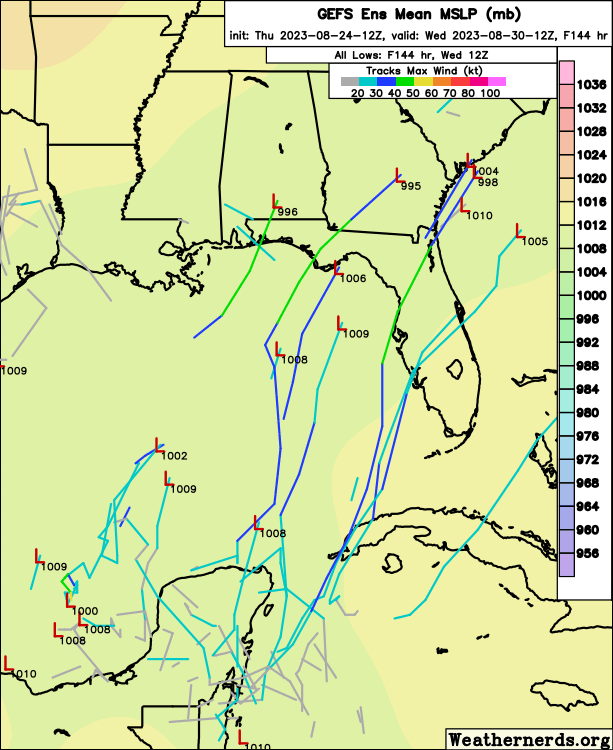
GFS 06Z appearing to finally lean into a deeper low then prior runs showing only a stretched-out trough crossing Florida. This not only appears in line with nearly all global models (even the hapless NOGAPS), but even as depicted by regional RGEM mesoscale. With potential Panama City to Tampa landfall projected no earlier than 0Z Wed., I'd guess that NHC would not see a reason for considering PTS advisories any earlier then Sunday evening. At the same time, NHC will likely increase the drumbeat by later today to increase awareness given how most people tend to detach from the news a bit over the weekend. I'd guess we'll see chances of development of 30/90 by this evening along with stronger language for Florida W. Coast and E. Panhandle for coastal interests as well as heavy rainfall/localized flooding risk that may threaten by mid-week. Reality is, nothing is going to develop super-fast and i'd guess that a high-end TS will impact around Cedar Key around late Wednesday.
3 likes
Personal Forecast Disclaimer:
The posts in this forum are NOT official forecast and should not be used as such. They are just the opinion of the poster and may or may not be backed by sound meteorological data. They are NOT endorsed by any professional institution or storm2k.org. For official information, please refer to the NHC and NWS products.
The posts in this forum are NOT official forecast and should not be used as such. They are just the opinion of the poster and may or may not be backed by sound meteorological data. They are NOT endorsed by any professional institution or storm2k.org. For official information, please refer to the NHC and NWS products.

Re: Low Pressure in the Northwest Caribbean Sea
SFLcane wrote:NDG wrote:Very evident surface vorticity on vis sat this morning, but fairly broad at this time.
https://i.imgur.com/1U3AsCU.gif
Lonnng way from being classified thats for sure.
depends on your definition of lonnnng....NHC odds imply they think it will within 5 days
0 likes
Just like Jon Snow..."I know nothing" except what I know, and most of what I know is gathered by the fine people of the NHC
Re: Low Pressure in the Northwest Caribbean Sea
We're at the time of the year where the climo tailwind kicks in. 50kt slop storm ts to cedar key remains my non professional guess. West Central FL needs the rain desperately so this would put them in a good spot for needed rains.
0 likes
-
SFLcane
- S2K Supporter
- Posts: 9606
- Age: 46
- Joined: Sat Jun 05, 2010 1:44 pm
- Location: Lake Worth Florida
Re: Low Pressure in the Northwest Caribbean Sea
wxman57 wrote:No TD until maybe Monday. North of Tampa sunrise Wed. 55kts.
2023 the year of the tropical storms.
1 likes
-
USTropics
- Category 5
- Posts: 2414
- Joined: Sun Aug 12, 2007 3:45 am
- Location: Florida State University
Re: Low Pressure in the Northwest Caribbean Sea
4 run trend of the ECMWF ensembles:
GFS ensembles:
GFS ensembles:
1 likes
-
Spacecoast

- Category 2

- Posts: 687
- Joined: Thu Aug 31, 2017 2:03 pm
Re: Possible Development in the Northwestern Caribbean
wxman57 wrote:No TD until maybe Monday. North of Tampa sunrise Wed. 55kts.
Is this 55kts, @ 10m? Weathernerds (above) shows ~35-45knts.
0 likes

Re: Low Pressure in the Northwest Caribbean Sea
I know people are naturally more concerned about the FL landfall, but depending on track, the system may achieve its peak intensity in the subtropical Atlantic once it emerges back over water. Euro has been showing this consistently, and there are also some hints on the CMC (though it doesn't always keep the system as a TC). Can add a bit more ACE if this verifies.
Land impacts beyond FL can't be ruled out, either. Euro is currently showing a Fiona-like scenario where the system takes a sudden left turn towards Nova Scotia and Newfoundland. CMC shows it affecting the same regions as an extratropical cyclone.
Land impacts beyond FL can't be ruled out, either. Euro is currently showing a Fiona-like scenario where the system takes a sudden left turn towards Nova Scotia and Newfoundland. CMC shows it affecting the same regions as an extratropical cyclone.
1 likes
-
MississippiWx

- S2K Supporter
- Posts: 1535
- Joined: Sat Aug 14, 2010 1:44 pm
- Location: Hattiesburg, Mississippi
Re: Low Pressure in the Northwest Caribbean Sea
USTropics wrote:4 run trend of the ECMWF ensembles:
https://i.postimg.cc/1zPdgSYq/gifmaker-me-12.gif
GFS ensembles:
https://i.postimg.cc/NF7Dv2BC/gifmaker-me-13.gif
Selfishly (and likely unrealistic), I would love to see the westward shift continue in that Euro Ensemble. I've lost track of our consecutive 100+ degree days here in South MS and we have gone over a month now with no rain. This has never happened in my lifetime. My slim hope is models struggle to figure out where to consolidate the low and it winds up in the Central Gulf.
4 likes
This post is not an official forecast and should not be used as such. It is just the opinion of MississippiWx and may or may not be backed by sound meteorological data. It is not endorsed by any professional institution including storm2k.org. For Official Information please refer to the NHC and NWS products.
-
Hypercane_Kyle

- Category 5
- Posts: 2900
- Joined: Sat Mar 07, 2015 7:58 pm
- Location: Cape Canaveral, FL
Re: Low Pressure in the Northwest Caribbean Sea
You know what? I think I'm going to go bold on this one:
75 knot Cat 1 north of Cedar Key. This storm reminds me a lot of 1998's Hurricane Earl. Likely a one sided storm, highly sheared, but aligned just enough to where that sheer will provide some ventilation.
75 knot Cat 1 north of Cedar Key. This storm reminds me a lot of 1998's Hurricane Earl. Likely a one sided storm, highly sheared, but aligned just enough to where that sheer will provide some ventilation.
1 likes
My posts are my own personal opinion, defer to the National Hurricane Center (NHC) and other NOAA products for decision making during hurricane season.
-
Blown Away

- S2K Supporter
- Posts: 9863
- Joined: Wed May 26, 2004 6:17 am
Re: Low Pressure in the Northwest Caribbean Sea
IMO any delays in Franklin moving N will cause this AOI to move farther W once in the EGOM.
0 likes
Hurricane Eye Experience: David 79, Irene 99, Frances 04, Jeanne 04, Wilma 05...
Hurricane Brush Experience: Andrew 92, Erin 95, Floyd 99, Matthew 16, Irma 17, Ian 22, Nicole 22…
Hurricane Brush Experience: Andrew 92, Erin 95, Floyd 99, Matthew 16, Irma 17, Ian 22, Nicole 22…
-
cycloneye

- Admin

- Posts: 139097
- Age: 67
- Joined: Thu Oct 10, 2002 10:54 am
- Location: San Juan, Puerto Rico
Re: Low Pressure in the Northwest Caribbean Sea
Blown Away wrote:IMO any delays in Franklin moving N will cause this AOI to move farther W once in the EGOM.
Franklin is moving ESE now.
0 likes
Visit the Caribbean-Central America Weather Thread where you can find at first post web cams,radars
and observations from Caribbean basin members Click Here
and observations from Caribbean basin members Click Here
Who is online
Users browsing this forum: JetFuel_SE, NotSparta and 98 guests