Biggest underperformers and overperformers

This is the general tropical discussion area. Anyone can take their shot at predicting a storms path.

Moderator: S2k Moderators

Forum rules

The posts in this forum are NOT official forecasts and should not be used as such. They are just the opinion of the poster and may or may not be backed by sound meteorological data. They are NOT endorsed by any professional institution or STORM2K. For official information, please refer to products from the National Hurricane Center and National Weather Service.

Help Support Storm2K
Message
Author
zhukm29
Tropical Storm
Tropical Storm
Posts: 219
Joined: Tue Aug 28, 2018 2:37 pm

Re: Biggest underperformers and overperformers

#21 Postby zhukm29 » Sun Sep 10, 2023 1:00 pm

FireRat wrote:
galaxy401 wrote:
WalterWhite wrote:Lee is 100% an underperformer---no doubt about it. HAFS models expected it intensify to 170-180 knots, yet it only reached a measly 145 knots.


"Only" 145 kts. I feel you put your expectations way too high. You got a Cat 5 and you're still complaining.


Yeah a feat not even 2020 officially could pull off! But yeah all is relative I guess, with many expecting a Haiyan out of this thing like the models showed once Lee really took off. Definitely not an underperformer, more like performed as expected originally.


Lee is not an underperformer, period. I feel like we've all been spoiled by the past few years that a 145kt explosively intensifying Cat 5 could even be considered an underperformance. :lol:

It wasn't too long ago that we nearly went a decade without a single Category 5 in the Atlantic (officially, Felix 2007 -> Matthew 2016). Category 5 is not a guaranteed occurrence either even in perfect conditions, due to other factors such as ERCs, etc., so IMO any storm that manages to reach Cat 5 is not an underperformer.
5 likes   

User avatar
Hurricaneman
Category 5
Category 5
Posts: 7281
Age: 43
Joined: Tue Aug 31, 2004 3:24 pm
Location: central florida

Re: Biggest underperformers and overperformers

#22 Postby Hurricaneman » Sun Sep 10, 2023 1:54 pm

Dorian in 2019 was only expected to get to 45mph on the first advisory but ended up being one of the strongest hurricanes on the Atlantic not in the Caribbean or GOM
7 likes   

User avatar
FireRat
Category 5
Category 5
Posts: 1138
Age: 36
Joined: Sun Sep 26, 2010 11:38 pm
Location: North Carolina

Re: Biggest underperformers and overperformers

#23 Postby FireRat » Sun Sep 10, 2023 3:14 pm

Lee is apparently getting pretty pissed :lol:
0 likes   
Georges '98, Irene '99, Frances '04, Jeanne '04, Katrina '05, Wilma '05, Gustav '08, Isaac '12, Matthew '16, Florence '18, Michael '18, Ian '22

User avatar
Ubuntwo
Category 5
Category 5
Posts: 1089
Age: 30
Joined: Thu Oct 05, 2017 10:41 pm

Re: Biggest underperformers and overperformers

#24 Postby Ubuntwo » Sun Sep 10, 2023 3:32 pm

WalterWhite wrote:Lee is 100% an underperformer---no doubt about it. HAFS models expected it intensify to 170-180 knots, yet it only reached a measly 145 knots.

The same HAFS that brought Franklin to 160kt? They're still experimental models and, it should be said, the only guidance that brought Lee to those soaring heights. By all other metrics Lee overperformed.
5 likes   
Kendall -> SLO -> PBC

Memorable Storms: Katrina (for its Florida landfall...) Wilma Matthew Irma

User avatar
Ubuntwo
Category 5
Category 5
Posts: 1089
Age: 30
Joined: Thu Oct 05, 2017 10:41 pm

Re: Biggest underperformers and overperformers

#25 Postby Ubuntwo » Sun Sep 10, 2023 3:41 pm

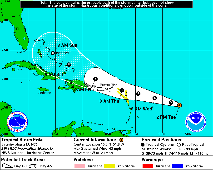
Erika worth a mention in the 'underperformer' category...
Image
5 likes   
Kendall -> SLO -> PBC

Memorable Storms: Katrina (for its Florida landfall...) Wilma Matthew Irma

User avatar
xtyphooncyclonex
Category 5
Category 5
Posts: 3688
Age: 22
Joined: Sat Dec 08, 2012 9:07 am
Location: Cebu City
Contact:

Re: Biggest underperformers and overperformers

#26 Postby xtyphooncyclonex » Sun Sep 10, 2023 5:49 pm

Dorian was forecast to hit the Bahamas as a tropical storm. We all knew how that turned out.

Image

Dora was quite the opposite of Lee this year, being forecast to weaken to a category 1-2 several times but instead stayed at Cat 4 for a whopping 146 nonconsecutive hours --- the EPac record longest.
5 likes   
REMINDER: My opinions that I, or any other NON Pro-Met in this forum, are unofficial. Please do not take my opinions as an official forecast and warning. I am NOT a meteorologist. Following my forecasts blindly may lead to false alarm, danger and risk if official forecasts from agencies are ignored.

dexterlabio
Category 5
Category 5
Posts: 3407
Joined: Sat Oct 24, 2009 11:50 pm

Re: Biggest underperformers and overperformers

#27 Postby dexterlabio » Sun Sep 10, 2023 7:09 pm

From the Western Pacific

Underachiever: Kammuri (2019) - victim of strong shear that popped out of nowhere :lol:

Overachiever: Noru (2022)
1 likes   
Personal Forecast Disclaimer:
The posts in this forum are NOT official forecast and should not be used as such. They are just the opinion of the poster and may or may not be backed by sound meteorological data. They are NOT endorsed by any professional institution or storm2k.org. For official information, please refer to the NHC and NWS products.

User avatar
Woofde
Category 1
Category 1
Posts: 267
Joined: Tue Jul 06, 2021 11:33 am

Re: RE: Re: Biggest underperformers and overperformers

#28 Postby Woofde » Sun Sep 10, 2023 7:17 pm

FireRat wrote:
galaxy401 wrote:
WalterWhite wrote:Lee is 100% an underperformer---no doubt about it. HAFS models expected it intensify to 170-180 knots, yet it only reached a measly 145 knots.


"Only" 145 kts. I feel you put your expectations way too high. You got a Cat 5 and you're still complaining.


Yeah a feat not even 2020 officially could pull off! But yeah all is relative I guess, with many expecting a Haiyan out of this thing like the models showed once Lee really took off. Definitely not an underperformer, more like performed as expected originally.
Poor Iota, I still can't believe they hit it with that postseason downgrade.
6 likes   

User avatar
xtyphooncyclonex
Category 5
Category 5
Posts: 3688
Age: 22
Joined: Sat Dec 08, 2012 9:07 am
Location: Cebu City
Contact:

Re: Biggest underperformers and overperformers

#29 Postby xtyphooncyclonex » Sun Sep 10, 2023 8:33 pm

dexterlabio wrote:From the Western Pacific

Underachiever: Kammuri (2019) - victim of strong shear that popped out of nowhere :lol:

Overachiever: Noru (2022)

Kammuri definitely struggled so much... could have lasted days as a cat 3+ if not for the shear. But that ramped up so quick right before Sorsogon.

Noru was such a surprise. No one would've thought that tiny thing would not just go way farther south, but hit category five right before landfall.

I'd also like to add Rai which made me rethink tracking storms myself. Everyone was expecting a cat 1-2 hit over VisMin and it exploded overnight into a 150-kt monster. Definitely demonstrated the PH Sea effect
1 likes   
REMINDER: My opinions that I, or any other NON Pro-Met in this forum, are unofficial. Please do not take my opinions as an official forecast and warning. I am NOT a meteorologist. Following my forecasts blindly may lead to false alarm, danger and risk if official forecasts from agencies are ignored.

User avatar
aspen
Category 5
Category 5
Posts: 8057
Joined: Sat Oct 12, 2019 7:10 pm
Location: Connecticut, USA

Re: Biggest underperformers and overperformers

#30 Postby aspen » Mon Sep 11, 2023 5:42 am

Haven’t seen Larry ‘21 or Earl ‘22 mentioned yet. Both could’ve become Cat 4s, but due to internal dynamics, they maxed out as a 3 and a 2, respectively. I remember Larry kept trying to undergo an EWRC with like a 100 mile wide outer eyewall.

Ian was a huge over-performer comparable to Michael. At first it seemed like shear would keep a lid on it, but it managed to get oriented just right for the shear to ventilate it instead. There were a lot of model runs that took it further north into the Gulf where shear ripped it apart, but it stayed further south and was able to intensify.
2 likes   
Irene '11 Sandy '12 Hermine '16 5/15/2018 Derecho Fay '20 Isaias '20 Elsa '21 Henri '21 Ida '21

I am only a meteorology enthusiast who knows a decent amount about tropical cyclones. Look to the professional mets, the NHC, or your local weather office for the best information.

dexterlabio
Category 5
Category 5
Posts: 3407
Joined: Sat Oct 24, 2009 11:50 pm

Re: Biggest underperformers and overperformers

#31 Postby dexterlabio » Mon Sep 11, 2023 7:24 pm

xtyphooncyclonex wrote:
dexterlabio wrote:From the Western Pacific

Underachiever: Kammuri (2019) - victim of strong shear that popped out of nowhere :lol:

Overachiever: Noru (2022)

Kammuri definitely struggled so much... could have lasted days as a cat 3+ if not for the shear. But that ramped up so quick right before Sorsogon.

Noru was such a surprise. No one would've thought that tiny thing would not just go way farther south, but hit category five right before landfall.

I'd also like to add Rai which made me rethink tracking storms myself. Everyone was expecting a cat 1-2 hit over VisMin and it exploded overnight into a 150-kt monster. Definitely demonstrated the PH Sea effect


I distinctly remember the models showing an intense cat5 hitting the Philippines days before Rai formed. It was just that the environment was looking too hostile and many people were thinking that it was just the models being bullish. But then Rai pulled off an ERI just like the models predicted, and the rest was history.


Here are the other storms that stuck to my memory for overachieving/underachieving

ATL
Danny and Joaquin 2015 (overachievers)
Humberto and Ingrid 2013 (underachievers)

WPAC
Vicente 2012 (overachiever- was forecast to stay as a weak to moderate TS but it suddenly developed an eye prior to landfall in China; made landfall as Cat4)
1 likes   
Personal Forecast Disclaimer:
The posts in this forum are NOT official forecast and should not be used as such. They are just the opinion of the poster and may or may not be backed by sound meteorological data. They are NOT endorsed by any professional institution or storm2k.org. For official information, please refer to the NHC and NWS products.

User avatar
doomhaMwx
Category 5
Category 5
Posts: 2398
Age: 25
Joined: Tue Apr 18, 2017 4:01 am
Location: Baguio/Benguet, Philippines
Contact:

Re: Biggest underperformers and overperformers

#32 Postby doomhaMwx » Mon Sep 11, 2023 8:09 pm

Overperformer: Mujigae (2015)
It was expected to hit Southern China as a category 1 typhoon but ended up RI'ing to a 115kt category 4 just within 12 hours before landfall. The attached images were JTWC's forecasts 24 hours and 12 hours before landfall.

Image
Image
2 likes   
Like my content? Consider giving a tip.

ChrisH-UK
Category 1
Category 1
Posts: 423
Joined: Sat May 29, 2021 8:22 am

Re: Biggest underperformers and overperformers

#33 Postby ChrisH-UK » Tue Sep 12, 2023 4:29 am

For this year TC Freddy was only expected to be a Cat 3 at first but then went to cat 5 and kept going and going and going. Eventually when it did made landfall in Madagascar after traveling from near Indonesia it reformed at hit Mozambique then came back out and hit Madagascar again and then Mozambique for the second time Freddy.

I think Freddy is the most overperforming TC of all time, with the longest lasting TC and the most ACE of any TC.
3 likes   

User avatar
doomhaMwx
Category 5
Category 5
Posts: 2398
Age: 25
Joined: Tue Apr 18, 2017 4:01 am
Location: Baguio/Benguet, Philippines
Contact:

Re: Biggest underperformers and overperformers

#34 Postby doomhaMwx » Tue Sep 12, 2023 6:35 am

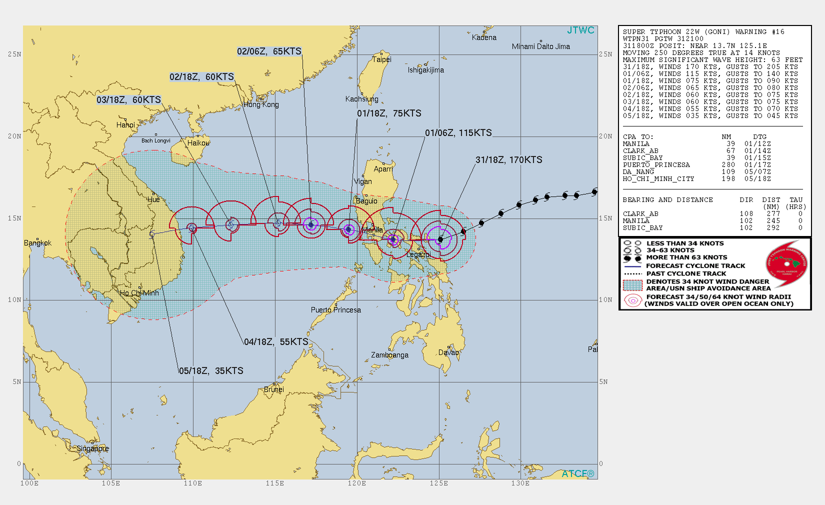
WPAC trackers will not forget how this pair in 2020 turned out: Goni (overperformer) and Atsani (underperformer).

Early model and agency forecasts for Goni weren't impressive. JTWC's first forecast was 90kt while JMA only initially expected a minimal typhoon. Nobody expected that we would be looking at a 170kt, Haiyan-level monster striking the Philippines a few days later.

Image
Image

On the other hand, models (even the usually bearish Euro) were so aggressive with Atsani that we thought it was going to be the highlight of the 2020 Typhoon Season. It ended up being a mere tropical storm :lol:. It might actually be the biggest underperformer I have ever witnessed.

Image
Image
4 likes   
Like my content? Consider giving a tip.

User avatar
ThunderForce
Tropical Storm
Tropical Storm
Posts: 158
Age: 25
Joined: Tue Sep 27, 2022 6:20 pm
Location: Florida Panhandle

Re: Biggest underperformers and overperformers

#35 Postby ThunderForce » Tue Sep 12, 2023 3:14 pm

I feel like Michael is an example of a hurricane that overperformed expectations. Initial NHC guidance was calling for it to be a tropical storm at landfall, but then the guidance said it would be a Category 1 later the same day. Later still it was stated it would be a 2 at landfall, and then 3, followed by 4... It just kept ramping up and up beyond the guidance. By the time it made landfall, it was a Category 5 and still didn't seem to have hit it's peak before weakening due to interaction with land.
1 likes   
Please refer to the NWS, NHC, SPC or a professional meteorologist for information and decision making during storms.

User avatar
Hammy
Category 5
Category 5
Posts: 5594
Age: 40
Joined: Fri May 25, 2012 5:25 pm
Contact:

Re: Biggest underperformers and overperformers

#36 Postby Hammy » Wed Sep 13, 2023 4:53 am

Humberto in 2007 was both an overperformer and highlights a dangerous situation that can occur: was forecast to come in at 40kt and moved onshore a mere 16 hours later at double that intensity, with a very well defined core taking shape as it was making landfall.

Image
2 likes   
The above post is not official and should not be used as such. It is the opinion of the poster and may or may not be backed by sound meteorological data. It is not endorsed by any professional institution or storm2k.org. For official information, please refer to the NHC and NWS products.

al78
Professional-Met
Professional-Met
Posts: 249
Joined: Thu Nov 01, 2018 12:20 pm

Re: Biggest underperformers and overperformers

#37 Postby al78 » Wed Sep 20, 2023 6:15 pm

Underperformers:

Hurricane Debby 2000. I vaguely remember concerns that it could approach southern Florida as a category 4 hurricane, in reality it peaked as a cat 1 then fell apart from land interaction with the Greater Antilles.

The 2007 hurricane season. A strong La Nina, two cat 5 hurricanes, yet the overall picture looked more like an El Nino year with an early shutdown with virtually nothing developing in October (why?) and a below average ACE. The unusual lack of late season activity during a La Nina event was repeated recently in the 2021 hurricane season (again what happened?).

Overperformers:

Hurricane Celia 2010, From the discussions:

800 AM PDT WED JUN 23 2010

WHILE ALL OF THE INTENSITY SHOWS SOME
STRENGTHENING OVER THE NEXT 24 TO 36 HOURS...NONE OF THE MODELS
MAKE CELIA A MAJOR HURRICANE.

800 AM PDT THU JUN 24 2010

NONE OF THE INTENSITY GUIDANCE SHOWS ANY STRENGTHENING OF
CELIA...AND THIS APPEARS SOMEWHAT UNREALISTIC GIVEN THE VERY
FAVORABLE UPPER-LEVEL WIND PATTERN AND RELATIVELY WARM WATERS THAT
CELIA IS OVER AT THE MOMENT.

800 PM PDT THU JUN 24 2010

SATELLITE IMAGES INDICATE THAT CELIA HAS RAPIDLY INTENSIFIED DURING
THE PAST SEVERAL HOURS.

Hurricane Charley 2004 and its rapid intensification from cat 2 to cat 4 just hours before landfall in SW Florida.
2 likes   

User avatar
Category5Kaiju
Category 5
Category 5
Posts: 3358
Age: 22
Joined: Thu Dec 24, 2020 12:45 pm
Location: Seattle

Re: Biggest underperformers and overperformers

#38 Postby Category5Kaiju » Wed Sep 20, 2023 6:37 pm

al78 wrote:Underperformers:

Hurricane Debby 2000. I vaguely remember concerns that it could approach southern Florida as a category 4 hurricane, in reality it peaked as a cat 1 then fell apart from land interaction with the Greater Antilles.

The 2007 hurricane season. A strong La Nina, two cat 5 hurricanes, yet the overall picture looked more like an El Nino year with an early shutdown with virtually nothing developing in October (why?) and a below average ACE. The unusual lack of late season activity during a La Nina event was repeated recently in the 2021 hurricane season (again what happened?).

Overperformers:

Hurricane Celia 2010, From the discussions:

800 AM PDT WED JUN 23 2010

WHILE ALL OF THE INTENSITY SHOWS SOME
STRENGTHENING OVER THE NEXT 24 TO 36 HOURS...NONE OF THE MODELS
MAKE CELIA A MAJOR HURRICANE.

800 AM PDT THU JUN 24 2010

NONE OF THE INTENSITY GUIDANCE SHOWS ANY STRENGTHENING OF
CELIA...AND THIS APPEARS SOMEWHAT UNREALISTIC GIVEN THE VERY
FAVORABLE UPPER-LEVEL WIND PATTERN AND RELATIVELY WARM WATERS THAT
CELIA IS OVER AT THE MOMENT.

800 PM PDT THU JUN 24 2010

SATELLITE IMAGES INDICATE THAT CELIA HAS RAPIDLY INTENSIFIED DURING
THE PAST SEVERAL HOURS.

Hurricane Charley 2004 and its rapid intensification from cat 2 to cat 4 just hours before landfall in SW Florida.


The one thing I do know about 2007 is that the season saw an Atlantic that was much colder compared to normal (see past sst anomalies maps). I also vaguely remember wx people talking about how 2007 and 2021 saw an early shutdown due to some trough or jet stream dipping down by October? Can't recall exactly though
0 likes   
Unless explicitly stated, all information covered in my posts is based on my opinions and observations. Please refer to a professional meteorologist or an accredited weather research agency otherwise, especially if serious decisions must be made in the event of a potentially life-threatening tropical storm or hurricane.

User avatar
Teban54
Category 5
Category 5
Posts: 1958
Joined: Sat May 19, 2018 1:19 pm

Re: Biggest underperformers and overperformers

#39 Postby Teban54 » Wed Sep 20, 2023 6:47 pm

The primary reason for 2021's late-season shutdown was the strong Atlantic Nino, which dragged the ITCZ further south. So instead of waves being sent into the Caribbean like 2020, they crashed into South America without development on the Atlantic side, and ended up developing after they reach EPAC and becoming Pamela, Rick, etc.
3 likes   

User avatar
Hurricane2022
Category 4
Category 4
Posts: 921
Joined: Tue Aug 23, 2022 11:38 pm
Location: Araçatuba, Brazil

Re: Biggest underperformers and overperformers

#40 Postby Hurricane2022 » Wed Sep 20, 2023 7:20 pm

Flopicane Nigel is an underperformer!
The depression is forecast to gradually intensify over the next
couple of days as moderate northeasterly shear and the initial broad
cyclone structure could provide a check on the intensification
rate. By early next week, this system is forecast to move over
near record warm sea-surface temperatures for the region in light
shear conditions. It probably sounds like a broken record at this
point in the season, but rapid intensification is a significant
possibility, and the official forecast could be conservative below.

The intensity forecast is near or above the intensity consensus,
only leveling off at 120 hours due to gradual SST cooling and the
possibility of eyewall replacement cycles, as suggested by the HAFS
model suite.

FORECAST POSITIONS AND MAX WINDS

INIT 15/1500Z 14.4N 43.8W 30 KT 35 MPH
12H 16/0000Z 15.5N 44.7W 35 KT 40 MPH
24H 16/1200Z 17.2N 46.0W 40 KT 45 MPH
36H 17/0000Z 18.9N 47.9W 50 KT 60 MPH
48H 17/1200Z 20.5N 49.6W 60 KT 70 MPH
60H 18/0000Z 22.0N 51.2W 70 KT 80 MPH
72H 18/1200Z 23.4N 52.9W 85 KT 100 MPH
96H 19/1200Z 26.0N 56.8W 105 KT 120 MPH
120H 20/1200Z 29.0N 60.0W 100 KT 115 MPH
3 likes   
Sorry for the bad English sometimes...!
For reliable and detailed information for any meteorological phenomenon, please consult the National Hurricane Center, Joint Typhoon Warning Center , or your local Meteo Center.

--------

Una cvm Christo, pro Christo, et in Christo. Sit nomen Domini benedictvm.


Return to “Talkin' Tropics”

Who is online

Users browsing this forum: MetroMike and 226 guests