Possible development in the SW Caribbean (Is Invest 98L)

This is the general tropical discussion area. Anyone can take their shot at predicting a storms path.

Moderator: S2k Moderators

Forum rules

The posts in this forum are NOT official forecasts and should not be used as such. They are just the opinion of the poster and may or may not be backed by sound meteorological data. They are NOT endorsed by any professional institution or STORM2K. For official information, please refer to products from the National Hurricane Center and National Weather Service.

Help Support Storm2K
Message
Author
jlauderdal
S2K Supporter
S2K Supporter
Posts: 6771
Joined: Wed May 19, 2004 5:46 am
Location: NE Fort Lauderdale
Contact:

Re: Possible development in the SW Caribbean

#21 Postby jlauderdal » Fri Nov 10, 2023 6:49 am

REDHurricane wrote:
kevin wrote:00z GFS

https://imgur.com/o1TuBuL


You know, one of these days the GFS will actually be spot-on with a sicko run like this and we'll all have to say sorry for making fun of it

I have been saying that for years and you are right, one of these days but until then, the gfs gets the type of attention it deserves.
4 likes   

User avatar
abajan
S2K Supporter
S2K Supporter
Posts: 4175
Joined: Sun Sep 07, 2003 5:10 am
Location: Barbados

Re: Possible development in the SW Caribbean

#22 Postby abajan » Fri Nov 10, 2023 7:04 am

Tropical Weather Outlook
NWS National Hurricane Center Miami FL
700 AM EST Fri Nov 10 2023

For the North Atlantic...Caribbean Sea and the Gulf of Mexico:

1. A broad area of low pressure could form in the southwestern
Caribbean Sea by the middle of next week. Some gradual development
of this system is possible thereafter while it moves little.
* Formation chance through 48 hours...low...near 0 percent.
* Formation chance through 7 days...low...20 percent.

$$
Forecaster Cangialosi
0 likes   

User avatar
wxman57
Moderator-Pro Met
Moderator-Pro Met
Posts: 22482
Age: 66
Joined: Sat Jun 21, 2003 8:06 pm
Location: Houston, TX (southwest)

Re: Possible development in the SW Caribbean

#23 Postby wxman57 » Fri Nov 10, 2023 8:43 am

Latest model runs, all valid for 12Z next Friday (within 7 days). ICON is indicating a 997mb TS, GFS a 991mb TS/H. Nothing in either the EC or CMC. I think the NHC's 20% is 30-40% too low for 7 days out. Maybe 50-60% through next Friday morning. Higher beyond then. GFS is likely way too strong. Most likely track NE toward Jamaica, eastern Cuba, and/or the DR then out to sea. Look for the NHC to bump their probabilities up considerably. Could just be a sheared TD or weak, sheared TS.

Image
9 likes   

User avatar
FireRat
Category 5
Category 5
Posts: 1138
Age: 36
Joined: Sun Sep 26, 2010 11:38 pm
Location: North Carolina

Re: Possible development in the SW Caribbean

#24 Postby FireRat » Fri Nov 10, 2023 11:10 am

REDHurricane wrote:
kevin wrote:00z GFS

https://imgur.com/o1TuBuL


You know, one of these days the GFS will actually be spot-on with a sicko run like this and we'll all have to say sorry for making fun of it


Wow, definitely one of the most jacked up GFS runs I've ever seen too! November 25 hurricane approaching FL keys from the Southeast after cruelly battering Cuba & Haiti like a Flora 1963 for days... it's like something out of a sci-fi movie! Lets hope this IS fiction!
1 likes   
Georges '98, Irene '99, Frances '04, Jeanne '04, Katrina '05, Wilma '05, Gustav '08, Isaac '12, Matthew '16, Florence '18, Michael '18, Ian '22

User avatar
Kazmit
Category 5
Category 5
Posts: 1915
Age: 21
Joined: Mon Jul 25, 2016 8:49 am
Location: Williamsburg VA for college, Bermuda otherwise

Re: Possible development in the SW Caribbean

#25 Postby Kazmit » Fri Nov 10, 2023 11:19 am

The 12z GFS is stronger once again. Another crazy run incoming?
0 likes   
Igor 2010, Sandy 2012, Fay 2014, Gonzalo 2014, Joaquin 2015, Nicole 2016, Humberto 2019

I am only a tropical weather enthusiast. My predictions are not official and may or may not be backed by sound meteorological data. For official information, please refer to the NHC and NWS products.

User avatar
SouthFLTropics
Category 5
Category 5
Posts: 4156
Age: 48
Joined: Thu Aug 14, 2003 8:04 am
Location: Port St. Lucie, Florida

Re: Possible development in the SW Caribbean

#26 Postby SouthFLTropics » Fri Nov 10, 2023 12:14 pm

HAHAHA... 12z GFS takes this all the way well to the Northeast of Puerto Rico and then brings it all the way back to the Bahamas and kills it off. You can certainly say that the GFS is anything but boring. It definitely has entertainment value. :lol:
1 likes   
Fourth Generation Floridian...With lots of storm knowledge passed down from my elders...

Personal Storm History: David 79, Andrew 92, Erin 95, Floyd 99, Irene 99, Frances 04, Jeanne 04, Wilma 05, Matthew 16, Irma 17

User avatar
cycloneye
Admin
Admin
Posts: 139087
Age: 67
Joined: Thu Oct 10, 2002 10:54 am
Location: San Juan, Puerto Rico

Re: Possible development in the SW Caribbean

#27 Postby cycloneye » Fri Nov 10, 2023 12:34 pm

Tropical Weather Outlook
NWS National Hurricane Center Miami FL
100 PM EST Fri Nov 10 2023

For the North Atlantic...Caribbean Sea and the Gulf of Mexico:

Southwestern Caribbean Sea:
A broad area of low pressure is forecast to form in the southwestern
Caribbean Sea by the middle of next week. Thereafter, environmental
conditions appear conducive for gradual development of this system
while it drifts slowly, remaining in the Caribbean Sea through the
latter part of next week.
* Formation chance through 48 hours...low...near 0 percent.
* Formation chance through 7 days...low...30 percent.

$$
Forecaster Papin
0 likes   
Visit the Caribbean-Central America Weather Thread where you can find at first post web cams,radars
and observations from Caribbean basin members Click Here

User avatar
Jr0d
S2K Supporter
S2K Supporter
Posts: 1174
Joined: Tue Aug 27, 2019 10:52 am
Location: Cayo Hueso

Re: Possible development in the SW Caribbean

#28 Postby Jr0d » Fri Nov 10, 2023 1:00 pm

jlauderdal wrote:
REDHurricane wrote:
kevin wrote:00z GFS

https://imgur.com/o1TuBuL


You know, one of these days the GFS will actually be spot-on with a sicko run like this and we'll all have to say sorry for making fun of it

I have been saying that for years and you are right, one of these days but until then, the gfs gets the type of attention it deserves.


The complete miss with Otis is concerning. While highly unlikely, if that situation were to happen in the Florida Keys there would be no time to evacuate and it would be a nightmare.

I am less concerned with the potential system with this run because of this, the general rule if the GFS has you in the cross hairs a week++ out, you are safe.
1 likes   

User avatar
abajan
S2K Supporter
S2K Supporter
Posts: 4175
Joined: Sun Sep 07, 2003 5:10 am
Location: Barbados

Re: Possible development in the SW Caribbean

#29 Postby abajan » Fri Nov 10, 2023 1:41 pm

1 likes   

User avatar
wxman57
Moderator-Pro Met
Moderator-Pro Met
Posts: 22482
Age: 66
Joined: Sat Jun 21, 2003 8:06 pm
Location: Houston, TX (southwest)

Re: Possible development in the SW Caribbean

#30 Postby wxman57 » Fri Nov 10, 2023 1:57 pm

Jr0d wrote:
The complete miss with Otis is concerning. While highly unlikely, if that situation were to happen in the Florida Keys there would be no time to evacuate and it would be a nightmare.

I am less concerned with the potential system with this run because of this, the general rule if the GFS has you in the cross hairs a week++ out, you are safe.


I think that one major issue with Otis was the lack of upper air data out over the Pacific for Otis. Not much data from Mexico, either. It's quite different in the Caribbean Sea. Plenty of surface and upper air data available. One think that the models all show is 50+ kts of SW wind shear across western Cuba, south Florida, and the Bahamas next week. I wouldn't be too concerned about any low tracking in that direction.
3 likes   

User avatar
cycloneye
Admin
Admin
Posts: 139087
Age: 67
Joined: Thu Oct 10, 2002 10:54 am
Location: San Juan, Puerto Rico

Re: Possible development in the SW Caribbean

#31 Postby cycloneye » Fri Nov 10, 2023 2:01 pm

Summary of 12z operational global models:

GFS and ICON=Develop.
CMC=Tries at the end of run to begin development.
ECMWF= Do not develop.
1 likes   
Visit the Caribbean-Central America Weather Thread where you can find at first post web cams,radars
and observations from Caribbean basin members Click Here

jlauderdal
S2K Supporter
S2K Supporter
Posts: 6771
Joined: Wed May 19, 2004 5:46 am
Location: NE Fort Lauderdale
Contact:

Re: Possible development in the SW Caribbean

#32 Postby jlauderdal » Fri Nov 10, 2023 2:29 pm

cycloneye wrote:
Tropical Weather Outlook
NWS National Hurricane Center Miami FL
100 PM EST Fri Nov 10 2023

For the North Atlantic...Caribbean Sea and the Gulf of Mexico:

Southwestern Caribbean Sea:
A broad area of low pressure is forecast to form in the southwestern
Caribbean Sea by the middle of next week. Thereafter, environmental
conditions appear conducive for gradual development of this system
while it drifts slowly, remaining in the Caribbean Sea through the
latter part of next week.
* Formation chance through 48 hours...low...near 0 percent.
* Formation chance through 7 days...low...30 percent.

$$
Forecaster Papin
NHC catching up to 57
1 likes   

User avatar
cycloneye
Admin
Admin
Posts: 139087
Age: 67
Joined: Thu Oct 10, 2002 10:54 am
Location: San Juan, Puerto Rico

Re: Possible development in the SW Caribbean

#33 Postby cycloneye » Fri Nov 10, 2023 6:14 pm

Nothing new or better known as copy and paste. :D

Tropical Weather Outlook
NWS National Hurricane Center Miami FL
700 PM EST Fri Nov 10 2023

For the North Atlantic...Caribbean Sea and the Gulf of Mexico:

1. Southwestern Caribbean Sea:
A broad area of low pressure is forecast to form in the southwestern
Caribbean Sea by the middle of next week. Thereafter, environmental
conditions appear conducive for gradual development of this system
while it meanders in the Caribbean Sea through the latter part of
next week.
* Formation chance through 48 hours...low...near 0 percent.
* Formation chance through 7 days...low...30 percent.

Forecaster Kelly
3 likes   
Visit the Caribbean-Central America Weather Thread where you can find at first post web cams,radars
and observations from Caribbean basin members Click Here

User avatar
wxman57
Moderator-Pro Met
Moderator-Pro Met
Posts: 22482
Age: 66
Joined: Sat Jun 21, 2003 8:06 pm
Location: Houston, TX (southwest)

Re: Possible development in the SW Caribbean

#34 Postby wxman57 » Fri Nov 10, 2023 7:55 pm

I think I'd go with 0% next 48 hrs and 60% beyond 48 hrs. EC and CMC still have nothing by next Friday evening. GFS has about a 50 kt TS. Huge circulation, which allows for a lower pressure but lower wind. ICON has a 35kt TS south of Jamaica. Movement would be NE - not toward the Gulf. Take a look at the GFS trend animation valid 12Z next Saturday. Zero run-to-run consistency. I think sheared TD or weak, sheared TS is most likely.

Image

Image
2 likes   

User avatar
DorkyMcDorkface
Category 2
Category 2
Posts: 698
Age: 26
Joined: Mon Sep 30, 2019 1:32 pm
Location: Mid-Atlantic

Re: Possible development in the SW Caribbean

#35 Postby DorkyMcDorkface » Fri Nov 10, 2023 8:03 pm

Despite the operational Euro now showing no development the EPS still has a decent signal. Odd discrepancy.

Image
2 likes   
Floyd 1999 | Isabel 2003 | Hanna 2008 | Irene 2011 | Sandy 2012 | Isaias 2020

User avatar
ThunderForce
Tropical Storm
Tropical Storm
Posts: 158
Age: 25
Joined: Tue Sep 27, 2022 6:20 pm
Location: Florida Panhandle

Re: Possible development in the SW Caribbean

#36 Postby ThunderForce » Sat Nov 11, 2023 6:26 am

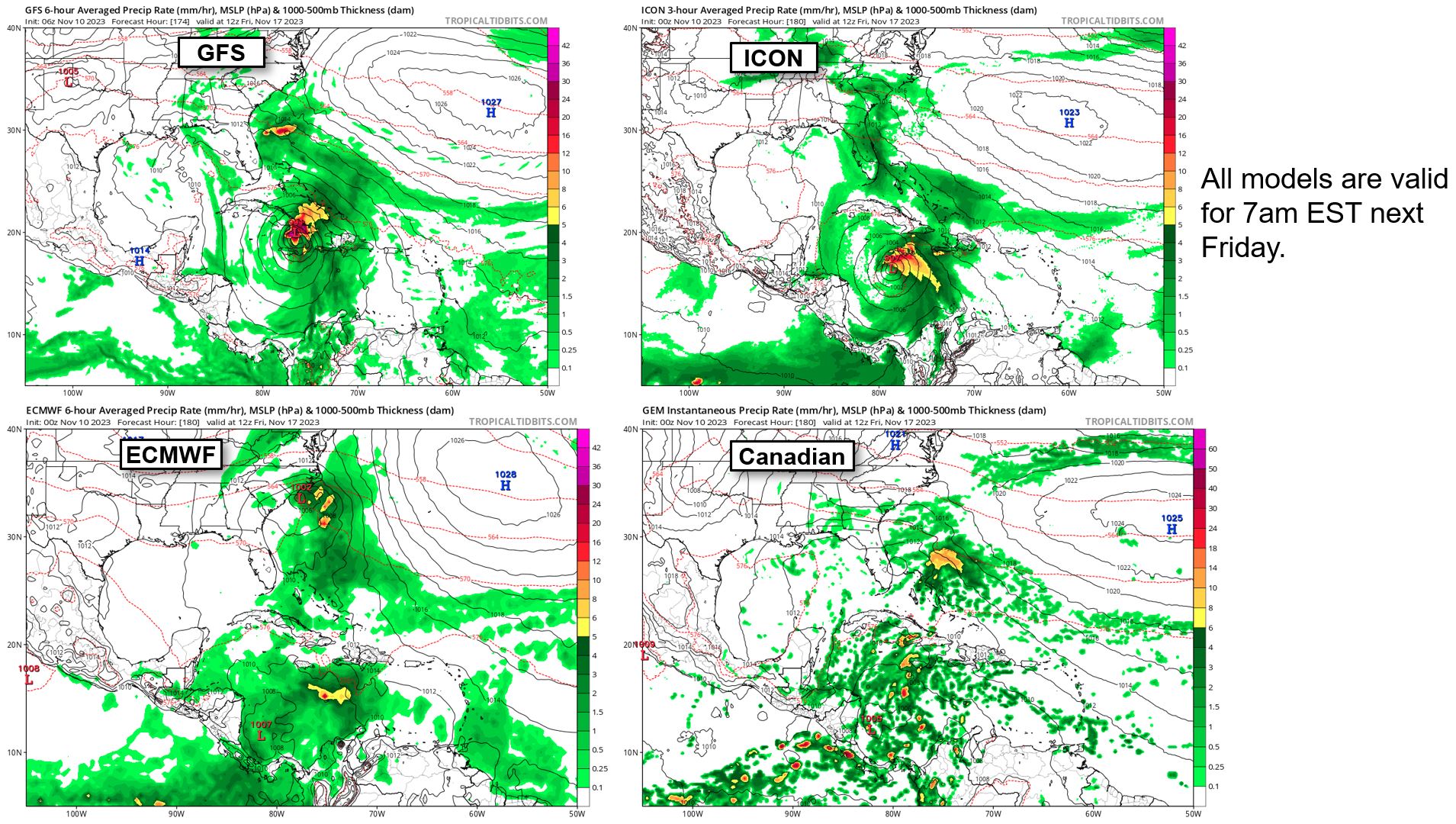
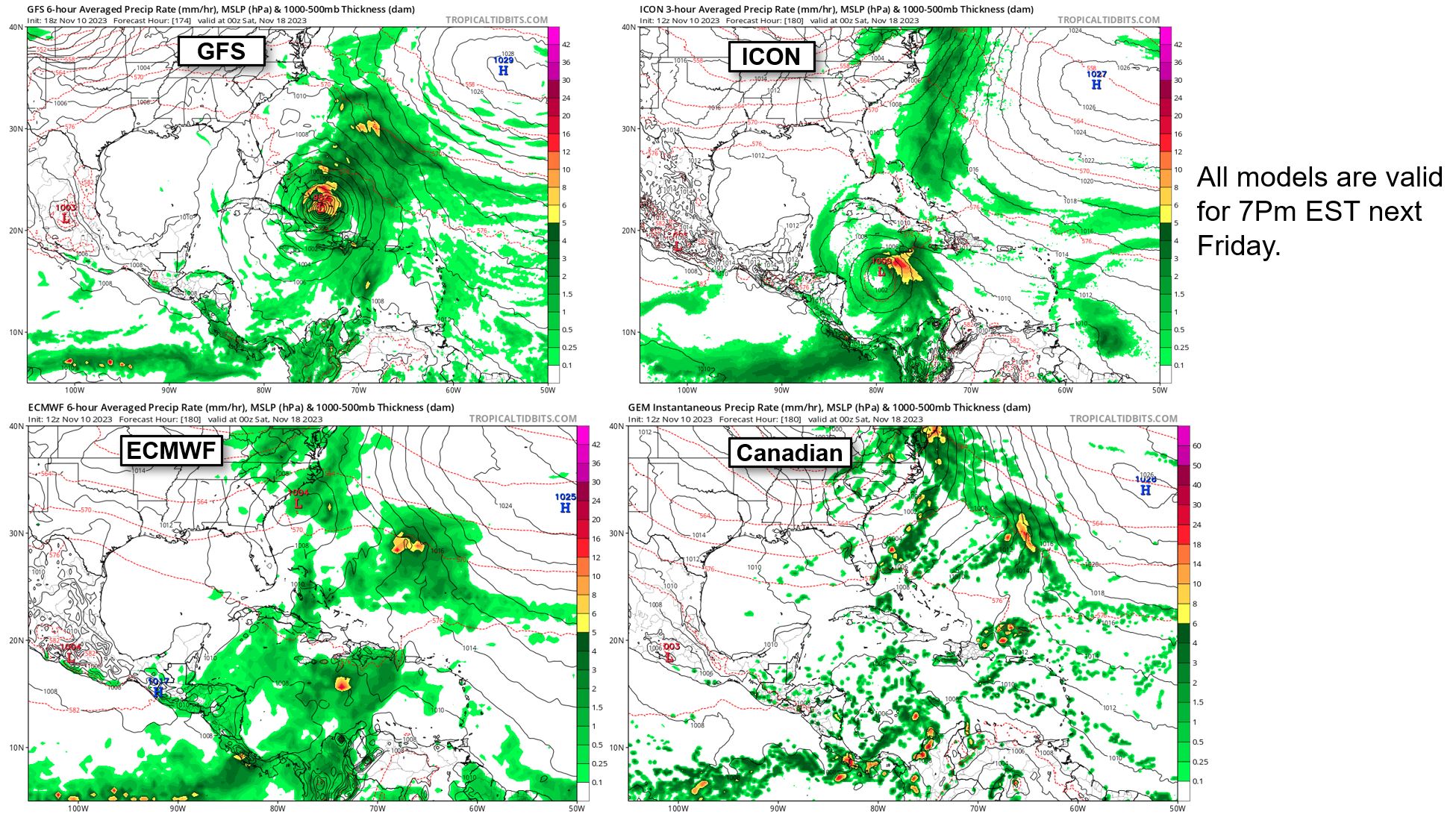
00z ICON seems to have dropped significant development and both 00z Euro and CMC are still not really showing much, which leaves 00z/06z GFS as the only operational model really developing this at the moment. In turn, this means GFS is the only one really showing it move NE through the Caribbean and into the Atlantic as a tropical storm/hurricane, with the other three models having the weaker low getting left behind by the trough and meandering in the southwestern Caribbean through their periods. To summarize the four models so far (to the best of my ability):

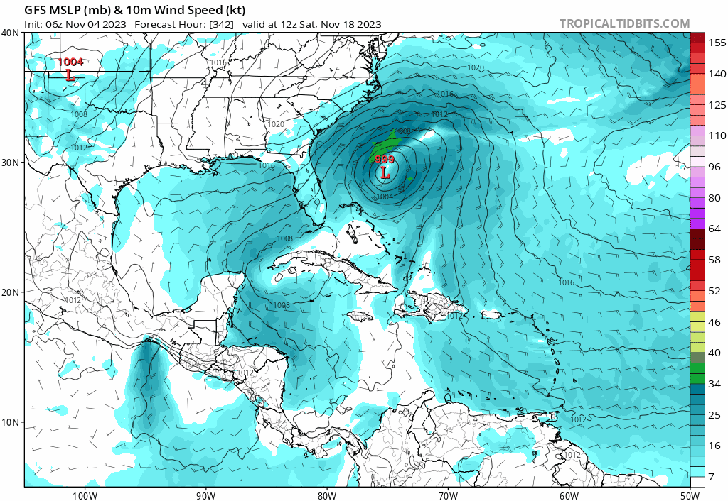
00z and 06z GFS develop it into a tropical storm/hurricane that moves northeast into the northwest/northern Caribbean and out into the Atlantic. 06z appears to be a bit weaker pressure-wise at first than 00z. 06z has it at 994 mb on 06z Friday the 17th, while 00z has it at 991 mb at the same time.

00z Euro doesn't develop it much while the trough is moving out. It does seem to try developing it afterward around hour 222 according to the "500 mb Geopotential Height, Cyclonic Vorticity, and Wind" map since the vorticity strengthens there into a red color, but it stops afterward. The low proceeds to meander in the southwestern Caribbean for the rest of the forecast period, with what appears to be slow northwest movement of the low beginning near the end.

00z CMC doesn't appear to develop it much, if at all. It does have vorticity at around hour 210 that moves into Nicaragua, but that appears to suddenly appear near Panama and doesn't appear to be related to the vorticity that the NHC is anticipating.

00z ICON seems to meander through the SW Caribbean as either a tropical low or depression throughout its period with little development.
2 likes   
Please refer to the NWS, NHC, SPC or a professional meteorologist for information and decision making during storms.

User avatar
cycloneye
Admin
Admin
Posts: 139087
Age: 67
Joined: Thu Oct 10, 2002 10:54 am
Location: San Juan, Puerto Rico

Re: Possible development in the SW Caribbean

#37 Postby cycloneye » Sat Nov 11, 2023 6:40 am

Tropical Weather Outlook
NWS National Hurricane Center Miami FL
700 AM EST Sat Nov 11 2023

For the North Atlantic...Caribbean Sea and the Gulf of Mexico:

Southwestern Caribbean Sea:
A broad area of low pressure is forecast to form in the southwestern
Caribbean Sea around the middle of next week. Thereafter,
environmental conditions appear conducive for gradual development of
this system while it meanders in the Caribbean Sea into next
weekend.
* Formation chance through 48 hours...low...near 0 percent.
* Formation chance through 7 days...low...30 percent.

$$
Forecaster Cangialosi
1 likes   
Visit the Caribbean-Central America Weather Thread where you can find at first post web cams,radars
and observations from Caribbean basin members Click Here

User avatar
abajan
S2K Supporter
S2K Supporter
Posts: 4175
Joined: Sun Sep 07, 2003 5:10 am
Location: Barbados

Re: Possible development in the SW Caribbean

#38 Postby abajan » Sat Nov 11, 2023 7:41 am

0 likes   

User avatar
cycloneye
Admin
Admin
Posts: 139087
Age: 67
Joined: Thu Oct 10, 2002 10:54 am
Location: San Juan, Puerto Rico

Re: Possible development in the SW Caribbean

#39 Postby cycloneye » Sat Nov 11, 2023 12:28 pm

Tropical Weather Outlook
NWS National Hurricane Center Miami FL
100 PM EST Sat Nov 11 2023

For the North Atlantic...Caribbean Sea and the Gulf of Mexico:

Southwestern Caribbean Sea:
A broad area of low pressure is forecast to form in the southwestern
Caribbean Sea around the middle of next week. Thereafter,
environmental conditions appear conducive for gradual development of
this system while it meanders in the Caribbean Sea into the
following weekend.
* Formation chance through 48 hours...low...near 0 percent.
* Formation chance through 7 days...low...30 percent.

Forecaster Papín
0 likes   
Visit the Caribbean-Central America Weather Thread where you can find at first post web cams,radars
and observations from Caribbean basin members Click Here

User avatar
cycloneye
Admin
Admin
Posts: 139087
Age: 67
Joined: Thu Oct 10, 2002 10:54 am
Location: San Juan, Puerto Rico

Re: Possible development in the SW Caribbean

#40 Postby cycloneye » Sat Nov 11, 2023 1:58 pm

Well, 12z operational Euro turns very bullish. :D Has a solid TS but track is the contrary from GFS.

Image
3 likes   
Visit the Caribbean-Central America Weather Thread where you can find at first post web cams,radars
and observations from Caribbean basin members Click Here


Return to “Talkin' Tropics”

Who is online

Users browsing this forum: AnnularCane, Cpv17, Google [Bot], JtSmarts, mixedDanilo.E, ouragans, RomP, zzzh and 243 guests