2024 Indicators: SST's, MSLP, Shear, SAL, Steering, Instability (Day 16+ Climate Models)

This is the general tropical discussion area. Anyone can take their shot at predicting a storms path.

Moderator: S2k Moderators

Forum rules

The posts in this forum are NOT official forecasts and should not be used as such. They are just the opinion of the poster and may or may not be backed by sound meteorological data. They are NOT endorsed by any professional institution or STORM2K. For official information, please refer to products from the National Hurricane Center and National Weather Service.

Help Support Storm2K
Message
Author
User avatar
Teban54
Category 5
Category 5
Posts: 1958
Joined: Sat May 19, 2018 1:19 pm

Re: 2024 Indicators: SST's, MSLP, Shear, SAL, Steering, Instability (Day 16+ Climate Models)

#601 Postby Teban54 » Mon Apr 01, 2024 2:25 pm

DorkyMcDorkface wrote:
zzzh wrote:New Cansips is out, things still look very favorable though weaker compared to the last run.
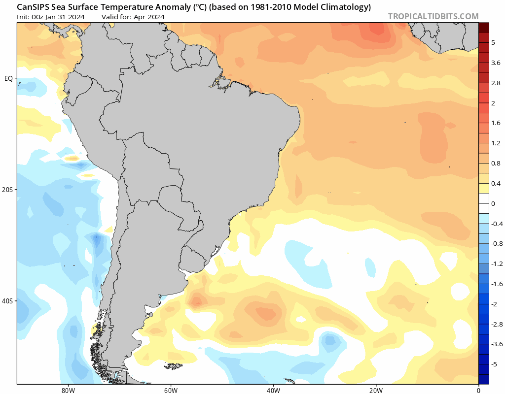
One thing I noticed is the South Atlantic sst:
https://i.postimg.cc/2yf3pNyj/cansips-ssta-noice-samer-fh0-trend.gif
Most models fail to capture the warmth in the south atlantic and now trend toward less +AMM and a more suppressed ITCZ.
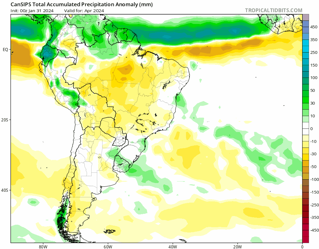
https://i.postimg.cc/Kz8LVKGN/cansips-apcpna-month-samer-fh0-trend.gif
You can see the wet anomaly shifts to the south of equator while the dry anomaly shifts to the north of equator.
Typically the AMM is phase-locked in the spring, and if the south atlantic does not cool down in the next 2 month, we are going to see enhanced trades over east atlantic/mdr this summer.

That's an interesting adjustment/caveat. Doesn't look like it cools the SATL that much by peak either, and you can see the resulting ITCZ shifting equatorward in this period as well as a result.

https://i.ibb.co/Z2XCQBG/cansips-ssta-Mean-noice-month-samer-fh6-trend.gif
https://i.ibb.co/YZkr2Fp/cansips-apcpna-multimonth-samer-fh6-trend.gif
MDR remains more or less the same in terms of well-above avg warmth so it doesn't appear to be too much of a negating factor, but it is probably worth keeping a watchful eye on how SSTs in the SATL evolve, especially if the other guidance follows suit in showing this.

https://i.ibb.co/nLqjGxD/cansips-ssta-Mean-noice-month-atl-fh6-trend-1.gif
https://i.ibb.co/MC7nmQb/90f81bfd-3ee8-4092-9044-fab5f102a2a1.gif

Andy Hazelton just cited a paper saying a stronger Atlantic Nino may result in an even more active CV season.
 https://twitter.com/AndyHazelton/status/1774879634712101149


 https://twitter.com/AndyHazelton/status/1774880248137458102


0 likes   

zzzh
Category 2
Category 2
Posts: 530
Joined: Thu Sep 02, 2021 1:13 pm

Re: 2024 Indicators: SST's, MSLP, Shear, SAL, Steering, Instability (Day 16+ Climate Models)

#602 Postby zzzh » Mon Apr 01, 2024 2:49 pm

Teban54 wrote:Andy Hazelton just cited a paper saying a stronger Atlantic Nino may result in an even more active CV season.
https://twitter.com/AndyHazelton/status/1774879634712101149?s=19
https://twitter.com/AndyHazelton/status/1774880248137458102?s=19

Image
That is true. However the SST configuration is slightly different. Those active years are more like +AMM and Atlantic Nino, with warmth centered at the equator and MDR/Canary Current, while the south Atlantic is less warm. This year so far the south Atlantic is just as warm as the north Atlantic, and models are trending toward a warmer S Atl during peak season.
0 likes   

User avatar
MHC Tracking
Tropical Storm
Tropical Storm
Posts: 169
Joined: Mon Mar 15, 2021 10:05 am

Re: 2024 Indicators: SST's, MSLP, Shear, SAL, Steering, Instability (Day 16+ Climate Models)

#603 Postby MHC Tracking » Mon Apr 01, 2024 4:34 pm

ThomasW wrote:The hype on this season feels a little bit premature. It's still March, folks... I'm not saying it'll "bust" but there's so much time for things to change. For all we know, July could be chok-a-blok with SAL that doesn't depart until mid-August. Or the + AMO could collapse. Or SSTs near Newfoundland could sharply rise by midsummer, leading to "wave-breaking". So many unanswered questions still, so we need to have patience and watch how things play out. :flag:

Agreed, even now the +AMO has been starting to cool down. So much doom and gloom about how we'll get 250 ACE or whatnot out there you'd think some people are wishing for a terrible season. I saw someone claiming it'd be the "worst ever". In general, I think people need to wait at least until May before starting to think seriously about seasonal activity beyond "probably above-average".
0 likes   

User avatar
Teban54
Category 5
Category 5
Posts: 1958
Joined: Sat May 19, 2018 1:19 pm

Re: 2024 Indicators: SST's, MSLP, Shear, SAL, Steering, Instability (Day 16+ Climate Models)

#604 Postby Teban54 » Mon Apr 01, 2024 4:41 pm

MHC Tracking wrote:
ThomasW wrote:The hype on this season feels a little bit premature. It's still March, folks... I'm not saying it'll "bust" but there's so much time for things to change. For all we know, July could be chok-a-blok with SAL that doesn't depart until mid-August. Or the + AMO could collapse. Or SSTs near Newfoundland could sharply rise by midsummer, leading to "wave-breaking". So many unanswered questions still, so we need to have patience and watch how things play out. :flag:

Agreed, even now the +AMO has been starting to cool down. So much doom and gloom about how we'll get 250 ACE or whatnot out there you'd think some people are wishing for a terrible season. I saw someone claiming it'd be the "worst ever". In general, I think people need to wait at least until May before starting to think seriously about seasonal activity beyond "probably above-average".

The +AMO cooling down from the absurd levels has been showing up on every global model output since January. That's hardly unexpected, and it has been shown repeatedly that even record-tying cooling still results in an MDR as warm as the warmest of years except 2023.
0 likes   

User avatar
StPeteMike
Category 1
Category 1
Posts: 358
Joined: Thu Jun 07, 2018 11:26 pm

Re: 2024 Indicators: SST's, MSLP, Shear, SAL, Steering, Instability (Day 16+ Climate Models)

#605 Postby StPeteMike » Mon Apr 01, 2024 4:45 pm

MHC Tracking wrote:
ThomasW wrote:The hype on this season feels a little bit premature. It's still March, folks... I'm not saying it'll "bust" but there's so much time for things to change. For all we know, July could be chok-a-blok with SAL that doesn't depart until mid-August. Or the + AMO could collapse. Or SSTs near Newfoundland could sharply rise by midsummer, leading to "wave-breaking". So many unanswered questions still, so we need to have patience and watch how things play out. :flag:

Agreed, even now the +AMO has been starting to cool down. So much doom and gloom about how we'll get 250 ACE or whatnot out there you'd think some people are wishing for a terrible season. I saw someone claiming it'd be the "worst ever". In general, I think people need to wait at least until May before starting to think seriously about seasonal activity beyond "probably above-average".

Even by May, might be too early. Things from May to September can easily change in conditions. I still think this season will be above average, but conditions like Sahara Dust increasing in distribution or stronger Caribbean trade winds and would be foolish to confidently say this season will be the worst season or season from hell.

Now, I’ll allow the thread to be back on subject. :)
1 likes   
The above post is not official and should not be used as such. It is the opinion of the poster and may or may not be backed by sound meteorological data. It is not endorsed by any professional institution or storm2k.org. For official information, please refer to the NHC and NWS products.

User avatar
MHC Tracking
Tropical Storm
Tropical Storm
Posts: 169
Joined: Mon Mar 15, 2021 10:05 am

Re: 2024 Indicators: SST's, MSLP, Shear, SAL, Steering, Instability (Day 16+ Climate Models)

#606 Postby MHC Tracking » Mon Apr 01, 2024 4:57 pm

Teban54 wrote:
MHC Tracking wrote:
ThomasW wrote:The hype on this season feels a little bit premature. It's still March, folks... I'm not saying it'll "bust" but there's so much time for things to change. For all we know, July could be chok-a-blok with SAL that doesn't depart until mid-August. Or the + AMO could collapse. Or SSTs near Newfoundland could sharply rise by midsummer, leading to "wave-breaking". So many unanswered questions still, so we need to have patience and watch how things play out. :flag:

Agreed, even now the +AMO has been starting to cool down. So much doom and gloom about how we'll get 250 ACE or whatnot out there you'd think some people are wishing for a terrible season. I saw someone claiming it'd be the "worst ever". In general, I think people need to wait at least until May before starting to think seriously about seasonal activity beyond "probably above-average".

The +AMO cooling down from the absurd levels has been showing up on every global model output since January. That's hardly unexpected, and it has been shown repeatedly that even record-tying cooling still results in an MDR as warm as the warmest of years except 2023.

You and I may know that, but many people (not specifically here) have been acting like it'll continue indefinitely, when the mere fact that NAO phases change shows us that something like that would be near-impossible.
0 likes   

User avatar
cycloneye
Admin
Admin
Posts: 139091
Age: 67
Joined: Thu Oct 10, 2002 10:54 am
Location: San Juan, Puerto Rico

Re: 2024 Indicators: SST's, MSLP, Shear, SAL, Steering, Instability (Day 16+ Climate Models)

#607 Postby cycloneye » Mon Apr 01, 2024 5:01 pm

Ok folks. Let's stick to the topic of this thread that are the indicators that guide things for the upcomming hurricane season. SST's, MSLP, Shear, SAL, Steering, Instability and the +16 day Climate Models.
5 likes   
Visit the Caribbean-Central America Weather Thread where you can find at first post web cams,radars
and observations from Caribbean basin members Click Here

User avatar
cycloneye
Admin
Admin
Posts: 139091
Age: 67
Joined: Thu Oct 10, 2002 10:54 am
Location: San Juan, Puerto Rico

Re: 2024 Indicators: SST's, MSLP, Shear, SAL, Steering, Instability (Day 16+ Climate Models)

#608 Postby cycloneye » Mon Apr 01, 2024 8:35 pm

0 likes   
Visit the Caribbean-Central America Weather Thread where you can find at first post web cams,radars
and observations from Caribbean basin members Click Here

Cpv17
Category 5
Category 5
Posts: 4331
Joined: Wed Dec 07, 2016 2:24 pm
Location: Wharton/El Campo, TX

Re: 2024 Indicators: SST's, MSLP, Shear, SAL, Steering, Instability (Day 16+ Climate Models)

#609 Postby Cpv17 » Mon Apr 01, 2024 10:04 pm


1 and 2 early on and then 2 and 3 after mid September.
1 likes   

User avatar
ScottNAtlanta
Category 5
Category 5
Posts: 1998
Joined: Sat May 25, 2013 3:11 pm
Location: Atlanta, GA

Re: 2024 Indicators: SST's, MSLP, Shear, SAL, Steering, Instability (Day 16+ Climate Models)

#610 Postby ScottNAtlanta » Tue Apr 02, 2024 3:32 pm

Cpv17 wrote:


1 and 2 early on and then 2 and 3 after mid September.

I think Texas has more of a target on it than in previous years
0 likes   
The posts in this forum are NOT official forecast and should not be used as such. They are just the opinion of the poster and may or may not be backed by sound meteorological data. They are NOT endorsed by any professional institution or storm2k.org. For official information, please refer to the NHC and NWS products.

User avatar
ThomasW
Tropical Low
Tropical Low
Posts: 39
Age: 43
Joined: Thu May 19, 2022 10:59 am
Contact:

Re: 2024 Indicators: SST's, MSLP, Shear, SAL, Steering, Instability (Day 16+ Climate Models)

#611 Postby ThomasW » Wed Apr 03, 2024 12:42 pm

Teban54 wrote:
MHC Tracking wrote:
ThomasW wrote:The hype on this season feels a little bit premature. It's still March, folks... I'm not saying it'll "bust" but there's so much time for things to change. For all we know, July could be chok-a-blok with SAL that doesn't depart until mid-August. Or the + AMO could collapse. Or SSTs near Newfoundland could sharply rise by midsummer, leading to "wave-breaking". So many unanswered questions still, so we need to have patience and watch how things play out. :flag:

Agreed, even now the +AMO has been starting to cool down. So much doom and gloom about how we'll get 250 ACE or whatnot out there you'd think some people are wishing for a terrible season. I saw someone claiming it'd be the "worst ever". In general, I think people need to wait at least until May before starting to think seriously about seasonal activity beyond "probably above-average".

The +AMO cooling down from the absurd levels has been showing up on every global model output since January. That's hardly unexpected, and it has been shown repeatedly that even record-tying cooling still results in an MDR as warm as the warmest of years except 2023.

Very true. Back when I was first forecasting - in the days of the great Bob Sheets - we didn't start talking about the season from an activity standpoint until mid-May.
1 likes   

AutoPenalti
Category 5
Category 5
Posts: 3949
Age: 27
Joined: Mon Aug 17, 2015 4:16 pm
Location: Ft. Lauderdale, Florida

Re: 2024 Indicators: SST's, MSLP, Shear, SAL, Steering, Instability (Day 16+ Climate Models)

#612 Postby AutoPenalti » Fri Apr 05, 2024 7:47 am

Image
Slightly weaker Precip Anomalies, maybe some subsidence and dry air?
0 likes   
The posts in this forum are NOT official forecasts and should not be used as such. They are just the opinion of the poster and may or may not be backed by sound meteorological data. They are NOT endorsed by any professional institution or STORM2K. For official information, please refer to products from the NHC and NWS.


Model Runs Cheat Sheet:
GFS (5:30 AM/PM, 11:30 AM/PM)
HWRF, GFDL, UKMET, NAVGEM (6:30-8:00 AM/PM, 12:30-2:00 AM/PM)
ECMWF (1:45 AM/PM)

TCVN
is a weighted averaged

User avatar
SFLcane
S2K Supporter
S2K Supporter
Posts: 9606
Age: 46
Joined: Sat Jun 05, 2010 1:44 pm
Location: Lake Worth Florida

Re: 2024 Indicators: SST's, MSLP, Shear, SAL, Steering, Instability (Day 16+ Climate Models)

#613 Postby SFLcane » Fri Apr 05, 2024 8:48 am

AutoPenalti wrote:https://i.imgur.com/ebn8JxK.gif
Slightly weaker Precip Anomalies, maybe some subsidence and dry air?


 https://x.com/philklotzbach/status/1776227269771456590


1 likes   

User avatar
SFLcane
S2K Supporter
S2K Supporter
Posts: 9606
Age: 46
Joined: Sat Jun 05, 2010 1:44 pm
Location: Lake Worth Florida

Re: 2024 Indicators: SST's, MSLP, Shear, SAL, Steering, Instability (Day 16+ Climate Models)

#614 Postby SFLcane » Fri Apr 05, 2024 8:49 am

:eek: :eek:


Image
0 likes   

User avatar
cheezyWXguy
Category 5
Category 5
Posts: 5536
Joined: Mon Feb 13, 2006 12:29 am
Location: Dallas, TX

Re: 2024 Indicators: SST's, MSLP, Shear, SAL, Steering, Instability (Day 16+ Climate Models)

#615 Postby cheezyWXguy » Fri Apr 05, 2024 8:55 am

SFLcane wrote:
AutoPenalti wrote:https://i.imgur.com/ebn8JxK.gif
Slightly weaker Precip Anomalies, maybe some subsidence and dry air?


 https://x.com/philklotzbach/status/1776227269771456590


Yeah, that’s still an incredibly high output. Precip anomalies may be slightly down from the previous run but with a background state still so favorable, I don’t think it will matter. At this point, it’ll probably just come down to the factors involved in individual setups in the moment. Season looks busy to me
0 likes   

AutoPenalti
Category 5
Category 5
Posts: 3949
Age: 27
Joined: Mon Aug 17, 2015 4:16 pm
Location: Ft. Lauderdale, Florida

Re: 2024 Indicators: SST's, MSLP, Shear, SAL, Steering, Instability (Day 16+ Climate Models)

#616 Postby AutoPenalti » Fri Apr 05, 2024 9:17 am


Shows some potential CONUS threats or close recurves.
0 likes   
The posts in this forum are NOT official forecasts and should not be used as such. They are just the opinion of the poster and may or may not be backed by sound meteorological data. They are NOT endorsed by any professional institution or STORM2K. For official information, please refer to products from the NHC and NWS.


Model Runs Cheat Sheet:
GFS (5:30 AM/PM, 11:30 AM/PM)
HWRF, GFDL, UKMET, NAVGEM (6:30-8:00 AM/PM, 12:30-2:00 AM/PM)
ECMWF (1:45 AM/PM)

TCVN
is a weighted averaged

mixedDanilo.E
Tropical Depression
Tropical Depression
Posts: 72
Joined: Sun Nov 21, 2021 8:00 am

Re: 2024 Indicators: SST's, MSLP, Shear, SAL, Steering, Instability (Day 16+ Climate Models): ECMWF run from April is up

#617 Postby mixedDanilo.E » Fri Apr 05, 2024 10:38 am

Image
Image

This kinda caught me eye how much warmer the ECMWF SSTAs have pretty significantly uptrended in the subtropics between last month and this month. Maybe explains why precip and SLP has downtrended in some areas.
0 likes   

User avatar
ScottNAtlanta
Category 5
Category 5
Posts: 1998
Joined: Sat May 25, 2013 3:11 pm
Location: Atlanta, GA

Re: 2024 Indicators: SST's, MSLP, Shear, SAL, Steering, Instability (Day 16+ Climate Models)

#618 Postby ScottNAtlanta » Fri Apr 05, 2024 10:38 am

ThomasW wrote:
Teban54 wrote:
MHC Tracking wrote:Agreed, even now the +AMO has been starting to cool down. So much doom and gloom about how we'll get 250 ACE or whatnot out there you'd think some people are wishing for a terrible season. I saw someone claiming it'd be the "worst ever". In general, I think people need to wait at least until May before starting to think seriously about seasonal activity beyond "probably above-average".

The +AMO cooling down from the absurd levels has been showing up on every global model output since January. That's hardly unexpected, and it has been shown repeatedly that even record-tying cooling still results in an MDR as warm as the warmest of years except 2023.

Very true. Back when I was first forecasting - in the days of the great Bob Sheets - we didn't start talking about the season from an activity standpoint until mid-May.


I think they call that technological progress :D :D :D
1 likes   
The posts in this forum are NOT official forecast and should not be used as such. They are just the opinion of the poster and may or may not be backed by sound meteorological data. They are NOT endorsed by any professional institution or storm2k.org. For official information, please refer to the NHC and NWS products.

User avatar
Teban54
Category 5
Category 5
Posts: 1958
Joined: Sat May 19, 2018 1:19 pm

Re: 2024 Indicators: SST's, MSLP, Shear, SAL, Steering, Instability (Day 16+ Climate Models): ECMWF April run is up

#619 Postby Teban54 » Fri Apr 05, 2024 11:04 am

Keep in mind that Euro has a warm bias with ENSO since 2017, which may also be an alternative explanation for reduced precip anomalies.
 https://twitter.com/MJVentrice/status/1776252509230604379


 https://twitter.com/dmorris9661/status/1776266222130139468


 https://twitter.com/NDGMETCHEF/status/1776228491291140598


1 likes   

User avatar
blp
Category 5
Category 5
Posts: 2805
Age: 45
Joined: Thu Sep 09, 2004 7:51 pm
Location: Miami, FL
Contact:

Re: 2024 Indicators: SST's, MSLP, Shear, SAL, Steering, Instability (Day 16+ Climate Models): ECMWF April run is up

#620 Postby blp » Fri Apr 05, 2024 11:08 am

First look at October and as I suspected it looks scary. W. Caribbean is going to be primed. :eek:

Image
0 likes   
The following post is NOT an official forecast and should not be used as such. It is just the opinion of the poster and may or may not be backed by sound meteorological data. It is NOT endorsed by any professional institution including storm2k.org For Official Information please refer to the NHC and NWS products.


Return to “Talkin' Tropics”

Who is online

Users browsing this forum: Google [Bot], Killjoy12, KirbyDude25, Sciencerocks and 251 guests