http://www.ndbc.noaa.gov/station_page.p ... tion=42041
http://www.ndbc.noaa.gov/station_page.p ... tion=42001
The wind direction are not the same ENE and SSW at those 2 bouys and pressures are falling.But rain for sure will go to florida but I think no more than that in terms of a tropical system but this is the same system the models form a low off the east coast but not tropical or warm core.
Will it be warm core off the east coast? Well time will tell.
Low forming in GOM but not tropical
Moderator: S2k Moderators
Forum rules

The posts in this forum are NOT official forecasts and should not be used as such. They are just the opinion of the poster and may or may not be backed by sound meteorological data. They are NOT endorsed by any professional institution or STORM2K. For official information, please refer to products from the National Hurricane Center and National Weather Service.
-
cycloneye

- Admin

- Posts: 139082
- Age: 67
- Joined: Thu Oct 10, 2002 10:54 am
- Location: San Juan, Puerto Rico
Low forming in GOM but not tropical
Last edited by cycloneye on Wed Apr 30, 2003 7:26 pm, edited 3 times in total.
0 likes
Visit the Caribbean-Central America Weather Thread where you can find at first post web cams,radars
and observations from Caribbean basin members Click Here
and observations from Caribbean basin members Click Here

-
Rainband
West central and southwest Florida forecast discussion
My hat is off to the GFS...pressure are falling across the central
Gulf. Showers and thunderstorms look like a good bet. In fact if
the GFS works out we will see a pretty nice low level jet out ahead
over a developing low...implying decent low level shear. I just can
not imagine pressure falling as fast as the GFS indicates so I will
hold off on mentioning any strong thunderstorms at this time. Heavy
rain does look like a good bet...but even with the heavy rain of last
week...flood potential does not look that bad.
0 likes
-
cycloneye
- Admin
- Posts: 139082
- Age: 67
- Joined: Thu Oct 10, 2002 10:54 am
- Location: San Juan, Puerto Rico
Hummm interesting that discussion about the GFS but they not are so agressive as the GFS about a warm core tropical system in GOM.
0 likes
Visit the Caribbean-Central America Weather Thread where you can find at first post web cams,radars
and observations from Caribbean basin members Click Here
and observations from Caribbean basin members Click Here
-
vbhoutex

- Storm2k Executive
- Posts: 28974
- Age: 72
- Joined: Wed Oct 09, 2002 11:31 pm
- Location: Spring Branch area, Houston, TX
- Contact:
Without having looked at anything except your post and the sat pic Chad provided, I have a question for you Luis. Do you think this is a trend or the normal everyday beginning of pressure falls in the afternoon? Looks like yesterday, the bouys did the same thing only to come back up in pressure as usual. Is there anything else you see that makes you think this system could become a surface low?
0 likes
Skywarn, C.E.R.T.
Please click below to donate to STORM2K to help with the expenses of keeping the site going:

Please click below to donate to STORM2K to help with the expenses of keeping the site going:
-
cycloneye
- Admin
- Posts: 139082
- Age: 67
- Joined: Thu Oct 10, 2002 10:54 am
- Location: San Juan, Puerto Rico
Wind directions David in this instance are from diferent directions at 2 different bouys.Yes pressures fall more at afternoons but let's watch those bouys tonight to see what happens.
Last edited by cycloneye on Wed Apr 30, 2003 3:31 pm, edited 1 time in total.
0 likes
Visit the Caribbean-Central America Weather Thread where you can find at first post web cams,radars
and observations from Caribbean basin members Click Here
and observations from Caribbean basin members Click Here
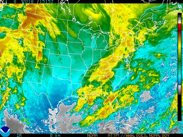
Yes, as the temperatures go up in the afternoon, the pressures do drop as the heat rises, and counters the pressure of the atmosphere on the earth. AVN and NOGAPS at 12Z both show the low pressure forming off Daytona then heading NE, then a second low pressure coming off the Carolina coast and deepening, with the NOGAPS really cranking the second low. Either way, I hope I get rain 
0 likes
-
Anonymous
-
cycloneye
- Admin
- Posts: 139082
- Age: 67
- Joined: Thu Oct 10, 2002 10:54 am
- Location: San Juan, Puerto Rico
Flood watches are posted for portions of south florida and that will be the sure thing from this.
0 likes
Visit the Caribbean-Central America Weather Thread where you can find at first post web cams,radars
and observations from Caribbean basin members Click Here
and observations from Caribbean basin members Click Here
-
ColdFront77
The area of convection in the Gulf of Mexico today looks more impressive in some ways then yesterday's. The length of time it existed today is longer than yesterday as well. Another big item of interest; the convection is moving more easterly, compared to yesterday southeasterly movement.
Rain and thunderstorms chances for central Florida are running 40 to 60 percent with this system tonight and tomorrow. A relatively rare event for Florida.
Rain and thunderstorms chances for central Florida are running 40 to 60 percent with this system tonight and tomorrow. A relatively rare event for Florida.
Last edited by ColdFront77 on Wed Apr 30, 2003 6:21 pm, edited 1 time in total.
0 likes
-
Rainband
-
Stormsfury

- Category 5

- Posts: 10549
- Age: 51
- Joined: Wed Feb 05, 2003 6:27 pm
- Location: Summerville, SC
Rainband wrote:Doesn't the stronger part of the feature seem to be drifting south..within the complex itself??
It's spreading that way due to right-turning (divergence aloft) plus some backbuilding (along the inflow jet on its SW tail) - and ridge-riding (rounding the zenith of an anticyclonic circulation)
0 likes