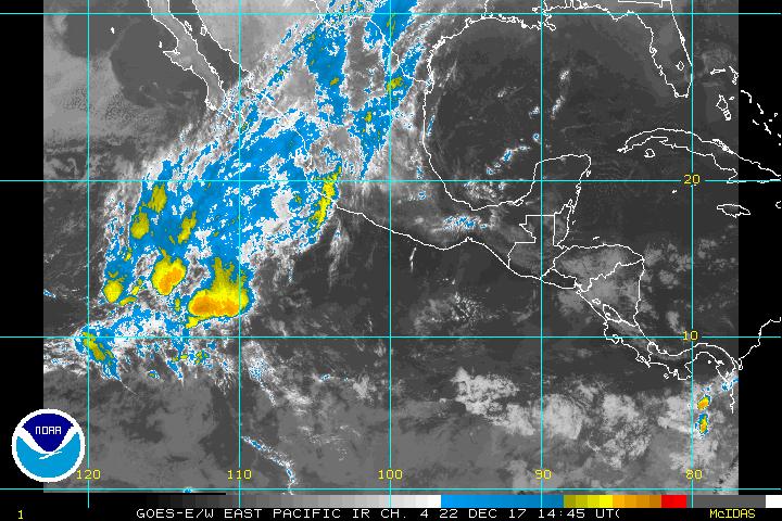
EPAC Flare-Up
Moderator: S2k Moderators
Forum rules
The posts in this forum are NOT official forecasts and should not be used as such. They are just the opinion of the poster and may or may not be backed by sound meteorological data. They are NOT endorsed by any professional institution or STORM2K. For official information, please refer to products from the National Hurricane Center and National Weather Service.
- wx247
- S2K Supporter

- Posts: 14279
- Age: 40
- Joined: Wed Feb 05, 2003 10:35 pm
- Location: Monett, Missouri
- Contact:
EPAC Flare-Up
Looks like an area of convection has flared up near 92W and 9N. My sat. loop isn't working right so I don't know if this has been persistent convection. Thoughts?
0 likes
Personal Forecast Disclaimer:
The posts in this forum are NOT official forecast and should not be used as such. They are just the opinion of the poster and may or may not be backed by sound meteorological data. They are NOT endorsed by any professional institution or storm2k.org. For official information, please refer to the NHC and NWS products.
The posts in this forum are NOT official forecast and should not be used as such. They are just the opinion of the poster and may or may not be backed by sound meteorological data. They are NOT endorsed by any professional institution or storm2k.org. For official information, please refer to the NHC and NWS products.
-
Rainband
- cycloneye
- Admin

- Posts: 139087
- Age: 67
- Joined: Thu Oct 10, 2002 10:54 am
- Location: San Juan, Puerto Rico
That is the invest that was out 2 days ago that some models suggest some development so let's see what happens with that area.
0 likes
Visit the Caribbean-Central America Weather Thread where you can find at first post web cams,radars
and observations from Caribbean basin members Click Here
and observations from Caribbean basin members Click Here
- wx247
- S2K Supporter

- Posts: 14279
- Age: 40
- Joined: Wed Feb 05, 2003 10:35 pm
- Location: Monett, Missouri
- Contact:
Ok. Thanks for the info. Didn't realize there was an invest. 
0 likes
Personal Forecast Disclaimer:
The posts in this forum are NOT official forecast and should not be used as such. They are just the opinion of the poster and may or may not be backed by sound meteorological data. They are NOT endorsed by any professional institution or storm2k.org. For official information, please refer to the NHC and NWS products.
The posts in this forum are NOT official forecast and should not be used as such. They are just the opinion of the poster and may or may not be backed by sound meteorological data. They are NOT endorsed by any professional institution or storm2k.org. For official information, please refer to the NHC and NWS products.
-
Rainband
Interestingly enough, some of the models (GFS and ECMWF) are hinting that this convection might meander after 48 hours and eventually pull north across Mexico and into the Bay of Campeche. If any wave entrains energy up that way or perhaps convection getting enchanced from a rogue ULL to the west, we could be looking at an interesting scenario 8-12 days out.
Always remember that in a retrogressive & trof splitting pattern in June (eastern trofs setting up further and further west), EPAC stuff can easily get entrained into the Gulf. It doesn't usually happen when convection develops into something stronger, but if remains relatively disorganized, watch what happens next week.
Steve
0 likes
- wx247
- S2K Supporter

- Posts: 14279
- Age: 40
- Joined: Wed Feb 05, 2003 10:35 pm
- Location: Monett, Missouri
- Contact:
Thanks for the info. Steve. Interesting indeed! 
0 likes
Personal Forecast Disclaimer:
The posts in this forum are NOT official forecast and should not be used as such. They are just the opinion of the poster and may or may not be backed by sound meteorological data. They are NOT endorsed by any professional institution or storm2k.org. For official information, please refer to the NHC and NWS products.
The posts in this forum are NOT official forecast and should not be used as such. They are just the opinion of the poster and may or may not be backed by sound meteorological data. They are NOT endorsed by any professional institution or storm2k.org. For official information, please refer to the NHC and NWS products.
- jabber
- Category 2

- Posts: 688
- Joined: Mon Mar 24, 2003 5:36 pm
- Location: Raleigh, NC (former Boynton Beach, Fl)
Models do
Show it making the move from west to east. The run this morning had the low much further north then it is. Lets see what happens.
Steve wrote:Interestingly enough, some of the models (GFS and ECMWF) are hinting that this convection might meander after 48 hours and eventually pull north across Mexico and into the Bay of Campeche. If any wave entrains energy up that way or perhaps convection getting enchanced from a rogue ULL to the west, we could be looking at an interesting scenario 8-12 days out.
Always remember that in a retrogressive & trof splitting pattern in June (eastern trofs setting up further and further west), EPAC stuff can easily get entrained into the Gulf. It doesn't usually happen when convection develops into something stronger, but if remains relatively disorganized, watch what happens next week.
Steve
0 likes
- chadtm80
- Category 5

- Posts: 20381
- Age: 43
- Joined: Tue Oct 08, 2002 8:35 am
- Location: East Central Florida
- Contact:
000
ABPZ20 KNHC 310947
TWOEP
TROPICAL WEATHER OUTLOOK
NWS TPC/NATIONAL HURRICANE CENTER MIAMI FL
4 AM PDT SAT MAY 31 2003
FOR THE EASTERN NORTH PACIFIC...EAST OF 140 DEGREES WEST LONGITUDE..
A TROPICAL DISTURBANCE WAS LOCATED 300 HUNDRED MILES SOUTH SOUTHWEST
OF THE GULF OF TEHUANTEPEC AND IS MOVING WNW AT 10 KT. DEVELOPMENT
IS POSSIBLE OVER THE NEXT DAY OR TWO.
ELSEWHERE...TROPICAL STORM FORMATION IS NOT EXPECTED THROUGH
SUNDAY.
FORECASTER BEVEN/RRG

0 likes
- cycloneye
- Admin

- Posts: 139087
- Age: 67
- Joined: Thu Oct 10, 2002 10:54 am
- Location: San Juan, Puerto Rico
Ready for the test chad because it is looking a good candidate as time goes by.
0 likes
Visit the Caribbean-Central America Weather Thread where you can find at first post web cams,radars
and observations from Caribbean basin members Click Here
and observations from Caribbean basin members Click Here

