
Invest 96L Near Az Islands,Comments,Sat Pics,Models Thread
Moderator: S2k Moderators
Forum rules

The posts in this forum are NOT official forecasts and should not be used as such. They are just the opinion of the poster and may or may not be backed by sound meteorological data. They are NOT endorsed by any professional institution or STORM2K. For official information, please refer to products from the National Hurricane Center and National Weather Service.
-
superfly
Invest 96L Near Az Islands,Comments,Sat Pics,Models Thread
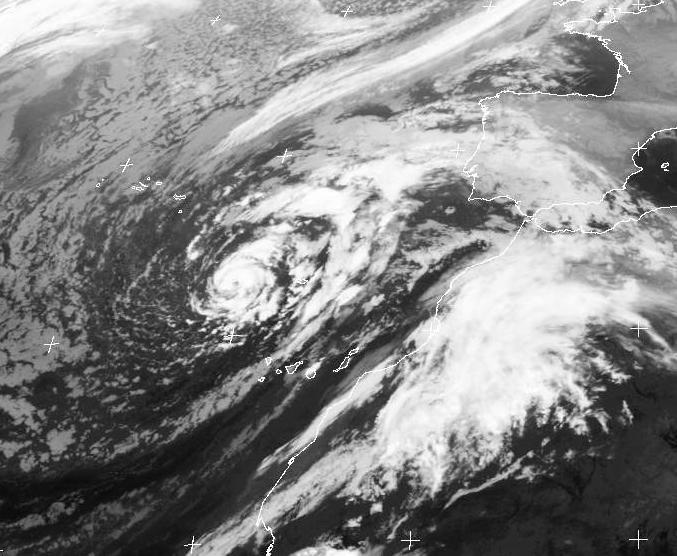
08/0600 UTC 32.8N 20.6W ST3.0/3.0 96 -- Atlantic Ocean
0 likes
-
Matt-hurricanewatcher
-
Matt-hurricanewatcher
-
TheEuropean

- Professional-Met

- Posts: 1797
- Age: 60
- Joined: Tue Sep 20, 2005 3:17 pm
- Location: Voerde, Germany
- Contact:
Matt-hurricanewatcher wrote:
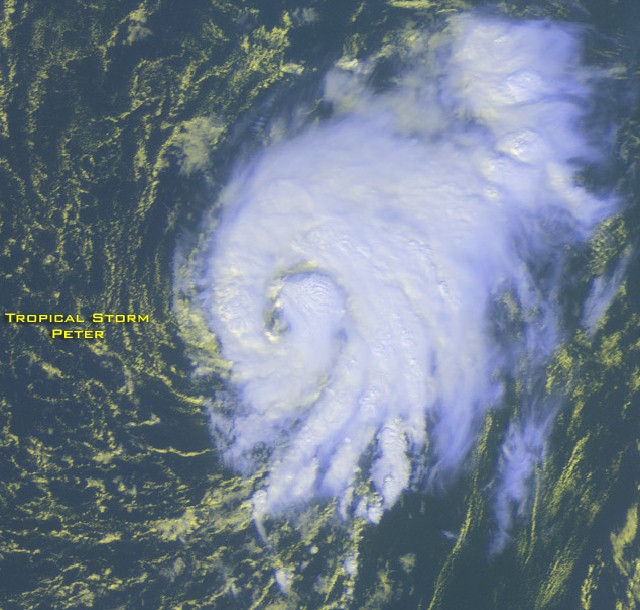
This system right now looks like Peter 2003.
But Peter was more to the southwest of the system today. Here is another satpic by University of Dundee:
and a pic of Peter:
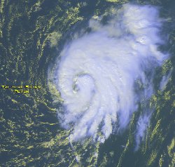
or big: http://www.saevert.de/atlantik/2003/031209petergr.jpg
There is a chance, that NHC will upgrad the subtropical system today.
0 likes


-
linkerweather

- Professional-Met
- Posts: 261
- Joined: Sat Jul 23, 2005 5:59 am
- Location: tampa bay area
-
Matt-hurricanewatcher
-
linkerweather
- Professional-Met
- Posts: 261
- Joined: Sat Jul 23, 2005 5:59 am
- Location: tampa bay area
I am a bit suprised myself that it doesn't get a mention. Not suprised though that they wouldn't give it a name considering it is almost to Europe. Although in 1995 there was some serious effects to the Azores from Tanya. In any event the only mention was one brief sentence fragment in the 2 am TWD.
A DEEP LAYER EASTERN ATLANTIC OCEAN LOW CENTER IS NEAR 34N20W.
A DEEP LAYER EASTERN ATLANTIC OCEAN LOW CENTER IS NEAR 34N20W.
0 likes
-
TheEuropean
- Professional-Met
- Posts: 1797
- Age: 60
- Joined: Tue Sep 20, 2005 3:17 pm
- Location: Voerde, Germany
- Contact:
linkerweather wrote:I am a bit suprised myself that it doesn't get a mention. Not suprised though that they wouldn't give it a name considering it is almost to Europe. Although in 1995 there was some serious effects to the Azores from Tanya. In any event the only mention was one brief sentence fragment in the 2 am TWD.
A DEEP LAYER EASTERN ATLANTIC OCEAN LOW CENTER IS NEAR 34N20W.
I watch this low very carefully because it will have influence on weather here in europe. The island of Madeira will feel some effects of this low - so why not name it as they did with Tanya?
0 likes
-
Matt-hurricanewatcher
-
apocalypt-flyer
- Category 1

- Posts: 468
- Joined: Sat Aug 27, 2005 11:51 am
-
HenkL
- S2K Supporter

- Posts: 2401
- Joined: Fri Sep 10, 2004 5:33 pm
- Location: Groningen, The Netherlands
- Contact:
from: WTNT80 EGRR 080559
TTROPICAL DEPRESSION ANALYSED POSITION : 32.0N 21.0W
ATCF IDENTIFIER :
VERIFYING TIME POSITION STRENGTH TENDENCY
-------------- -------- -------- --------
00UTC 08.10.2005 32.0N 21.0W WEAK WEAKENING SLIGHTLY
12UTC 08.10.2005 32.0N 20.5W WEAK LITTLE CHANGE
00UTC 09.10.2005 32.0N 19.8W WEAK WEAKENING SLIGHTLY
12UTC 09.10.2005 33.7N 19.0W WEAK WEAKENING SLIGHTLY
00UTC 10.10.2005 36.0N 18.0W WEAK LITTLE CHANGE
12UTC 10.10.2005 BELOW TROPICAL STORM STRENGTH
THIS INFORMATION IS PROVIDED AS GUIDANCE FOR TROPICAL CYCLONE
RSMCS. IT REQUIRES INTERPRETATION BY TROPICAL CYCLONE SPECIALISTS
AND SHOULD NOT BE CONSIDERED AS A FINAL PRODUCT
MET OFFICE, EXETER, UK
TOO 080559
0 likes
-
Hyperstorm

- Category 5

- Posts: 1500
- Joined: Sun Sep 07, 2003 3:48 am
- Location: Ocala, FL
As some have already said, I don't think the NHC would be bothered to make this a classified system.
First of all, it is located over SSTs that are not warm enough to support development (mid 70*s). As a result, convection is very shallow.
Secondly, the system is still likely to be mostly extratropical regardless of the subtropical clasifications. You can easily see the VERY cold cumulus clouds to the southwest and northwest. This tells you that it is drawing some cold air from the north.
Thirdly, there have been other mid-latitude cyclones being classified as subtropical by Dvorak in the far northern Atlantic, but were never classified by the NHC due to the above mentioned factors.
Last, but not least...it is located in the EXTREME far northeastern Atlantic ocean, just northwest of the Canary Islands. This is an area that has not seen a tropical cyclone develop. There was only ONE recorded case in 150 years of history, but that was actually a little further west than where the system is. As James mentioned, that was Hurricane Ivan in 1980. SSTs must be WAY above normal for that to happen.
It appears that this system has stopped its southward progress and should begin to move poleward very soon.
0 likes
-
Hurricanehink

- S2K Supporter
- Posts: 2047
- Joined: Sun Nov 16, 2003 2:05 pm
- Location: New Jersey

Now TPC mentions it:
496
ABNT20 KNHC 081516
TWOAT
TROPICAL WEATHER OUTLOOK
NWS TPC/NATIONAL HURRICANE CENTER MIAMI FL
1130 AM EDT SAT OCT 8 2005
FOR THE NORTH ATLANTIC...CARIBBEAN SEA AND THE GULF OF MEXICO...
SATELLITE IMAGERY INDICATES THAT SHOWER ACTIVITY HAS INCREASED IN
ASSOCIATION WITH A NON-TROPICAL LOW PRESSURE LOCATED ABOUT MIDWAY
BETWEEN THE AZORES AND THE CANARY ISLANDS. WHILE THIS SYSTEM IS
OVER RELATIVELY COLD SEA SURFACE TEMPERATURES...IT WILL BE
MONITORED FOR ANY ADDITIONAL SIGNS OF SUBTROPICAL CYCLONE
DEVELOPMENT.
0 likes
-
Tampa Bay Hurricane

- Category 5
- Posts: 5598
- Age: 38
- Joined: Fri Jul 22, 2005 7:54 pm
- Location: St. Petersburg, FL
-
HURAKAN

- Professional-Met
- Posts: 46086
- Age: 38
- Joined: Thu May 20, 2004 4:34 pm
- Location: Key West, FL
- Contact:
TWD 2:05 PM:
An
upper low is embedded within the trough near 33n20w and oddly
enough a tight core of convection has developed within 45 nm of
the center...giving the system an almost tropical appearance. A
surface trough extends S and se of the low from the western
Canary Islands SW to 23n30w and is along the leading edge of a
stratocumulus field. Isolated showers may move across the canary
and Madeira islands...but this system is mostly cold-core and is
not expected to become tropical over the colder waters of the NE
Atlc.
Looks tropical but it's extratropical according to the NHC.
0 likes

Who is online
Users browsing this forum: JaviT and 95 guests