Not too fast El NIño.
https://twitter.com/webberweather/status/1673466502388019201
ENSO Updates (2007 thru 2023)
Moderator: S2k Moderators
Forum rules

The posts in this forum are NOT official forecasts and should not be used as such. They are just the opinion of the poster and may or may not be backed by sound meteorological data. They are NOT endorsed by any professional institution or STORM2K. For official information, please refer to products from the National Hurricane Center and National Weather Service.
-
cycloneye

- Admin

- Posts: 139130
- Age: 67
- Joined: Thu Oct 10, 2002 10:54 am
- Location: San Juan, Puerto Rico
Re: ENSO Updates
3 likes
Visit the Caribbean-Central America Weather Thread where you can find at first post web cams,radars
and observations from Caribbean basin members Click Here
and observations from Caribbean basin members Click Here
Re: ENSO; CPC weekly update: Niño 1+2 at +2.9C / Niño 3 at +1.4C / Niño 3.4 at +1.0C / Niño 4 at +0.7C
For the 2nd day in a row, all 3 cooled in 3.4:
-CDAS: cooled 0.018 to 0.880
-CRW: cooled 0.034 to 1.050
-OISST: cooled 0.066 to 0.877
Average today of 0.039 cooler vs prior 4 days' changes of -0.022, 0, +0.039, and +0.050.
For first time in weeks and possibly even months, OISST is cooler (albeit barely) than CDAS!
-CDAS: cooled 0.018 to 0.880
-CRW: cooled 0.034 to 1.050
-OISST: cooled 0.066 to 0.877
Average today of 0.039 cooler vs prior 4 days' changes of -0.022, 0, +0.039, and +0.050.
For first time in weeks and possibly even months, OISST is cooler (albeit barely) than CDAS!
0 likes
Personal Forecast Disclaimer:
The posts in this forum are NOT official forecasts and should not be used as such. They are just the opinion of the poster and may or may not be backed by sound meteorological data. They are NOT endorsed by any professional institution or storm2k.org. For official information, please refer to the NHC and NWS products.
The posts in this forum are NOT official forecasts and should not be used as such. They are just the opinion of the poster and may or may not be backed by sound meteorological data. They are NOT endorsed by any professional institution or storm2k.org. For official information, please refer to the NHC and NWS products.
Re: ENSO Updates
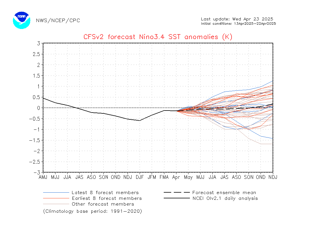
Unless I'm missing something, the brand new CFSv2 is significantly weaker with the 3.4 peak than the prior run (see link below). The 3 month is peaking at only ~+1.7 vs the prior run's just over +2.0. More than half of the latest ensemble members (blue) are cooler than +0.9 in July!
Link to latest CFSv2:
https://www.cpc.ncep.noaa.gov/products/ ... o34Sea.gif
Link to latest CFSv2:
https://www.cpc.ncep.noaa.gov/products/ ... o34Sea.gif
0 likes
Personal Forecast Disclaimer:
The posts in this forum are NOT official forecasts and should not be used as such. They are just the opinion of the poster and may or may not be backed by sound meteorological data. They are NOT endorsed by any professional institution or storm2k.org. For official information, please refer to the NHC and NWS products.
The posts in this forum are NOT official forecasts and should not be used as such. They are just the opinion of the poster and may or may not be backed by sound meteorological data. They are NOT endorsed by any professional institution or storm2k.org. For official information, please refer to the NHC and NWS products.
-
Kingarabian

- S2K Supporter

- Posts: 15437
- Joined: Sat Aug 08, 2009 3:06 am
- Location: Honolulu, Hawaii
Re: ENSO Updates
LarryWx wrote:Unless I'm missing something, the brand new CFSv2 is significantly weaker with the 3.4 peak than the prior run (see link below). The 3 month is peaking at only ~+1.7 vs the prior run's just over +2.0. More than half of the latest ensemble members (blue) are cooler than +0.9 in July!
Link to latest CFSv2:
https://www.cpc.ncep.noaa.gov/products/ ... o34Sea.gif
That's because of the strong July/August trades it's modeling out. Other models are also picking up on this.
2 likes
RIP Kobe Bryant

Re: ENSO Updates
Think we'll hold 1C next week. Some warming from the east but also some cooling from the west.
2 likes
The above post and any post by Ntxw is NOT an official forecast and should not be used as such. It is just the opinion of the poster and may or may not be backed by sound meteorological data. It is NOT endorsed by any professional institution including Storm2k. For official information, please refer to NWS products.
Help support Storm2K!
Re: ENSO Updates
3rd day in a row of 3.4 cooling but slower:
CDAS: cooled 0.047 to 0.833
CRW: cooled 0.024 to 1.026
OISST: cooled barely 0.004 to 0.873
Average today -0.025 vs prior 4 days' changes of -0.039, -0.022, 0, +0.039
Latest TAO map is slightly cooler
I predict BoA's +1.8 in 3.4 for July is going to bust way too warm.
CDAS: cooled 0.047 to 0.833
CRW: cooled 0.024 to 1.026
OISST: cooled barely 0.004 to 0.873
Average today -0.025 vs prior 4 days' changes of -0.039, -0.022, 0, +0.039
Latest TAO map is slightly cooler
I predict BoA's +1.8 in 3.4 for July is going to bust way too warm.
0 likes
Personal Forecast Disclaimer:
The posts in this forum are NOT official forecasts and should not be used as such. They are just the opinion of the poster and may or may not be backed by sound meteorological data. They are NOT endorsed by any professional institution or storm2k.org. For official information, please refer to the NHC and NWS products.
The posts in this forum are NOT official forecasts and should not be used as such. They are just the opinion of the poster and may or may not be backed by sound meteorological data. They are NOT endorsed by any professional institution or storm2k.org. For official information, please refer to the NHC and NWS products.

Re: ENSO Updates
LarryWx wrote:3rd day in a row of 3.4 cooling but slower:
CDAS: cooled 0.047 to 0.833
CRW: cooled 0.024 to 1.026
OISST: cooled barely 0.004 to 0.873
Average today -0.025 vs prior 4 days' changes of -0.039, -0.022, 0, +0.039
Latest TAO map is slightly cooler
I predict BoA's +1.8 in 3.4 for July is going to bust way too warm.
https://www.cpc.ncep.noaa.gov/products/ ... o34Sea.gif[/quote]
Nope, not missing anything. Spring predictability barrier is ending and it's passed time for the atmosphere to respond like 2015 or 1997. I wouldn't say a single ONI of >2.0C is completely off the table, but it is definitely becoming more unlikely. People forger that by this time time in 2015 and 1997, westerly wind anomalies were nearly constant by this time. We had some impressive WWB events in spring-early summer 2015 that I just don't recall happening this year. I think we will get a nino, but a moderate-to-strong to strong, as opposed to very strong (>2.0C for three ONI trimonthlies) . Id still predict it to be robust at peak though. Maybe a bit stronger than 2009
3 likes
All posts by Dean_175 are NOT official forecasts and should not be used as such. They are just the opinion of the poster and may or may not be backed by sound meteorological data. They are NOT endorsed by any professional institution or storm2k.org. For official information, please refer to the NHC and NWS products.
-
Kingarabian
- S2K Supporter
- Posts: 15437
- Joined: Sat Aug 08, 2009 3:06 am
- Location: Honolulu, Hawaii
Re: ENSO Updates
Dean_175 wrote:LarryWx wrote:3rd day in a row of 3.4 cooling but slower:
CDAS: cooled 0.047 to 0.833
CRW: cooled 0.024 to 1.026
OISST: cooled barely 0.004 to 0.873
Average today -0.025 vs prior 4 days' changes of -0.039, -0.022, 0, +0.039
Latest TAO map is slightly cooler
I predict BoA's +1.8 in 3.4 for July is going to bust way too warm.
https://www.cpc.ncep.noaa.gov/products/ ... o34Sea.gif
Nope, not missing anything. Spring predictability barrier is ending and it's passed time for the atmosphere to respond like 2015 or 1997. I wouldn't say a single ONI of >2.0C is completely off the table, but it is definitely becoming more unlikely. People forger that by this time time in 2015 and 1997, westerly wind anomalies were nearly constant by this time. We had some impressive WWB events in spring-early summer 2015 that I just don't recall happening this year. I think we will get a nino, but a moderate-to-strong to strong, as opposed to very strong (>2.0C for three ONI trimonthlies) . Id still predict it to be robust at peak though. Maybe a bit stronger than 2009
Subsurface, it's looking just as good as 2015. But the atmosphere is a different story. 2015 basically had a WWB or very weak trades near the dateline two thirds of each month until the event commenced. Not to forget the proper +PDO/+PMM coupling.
2 likes
RIP Kobe Bryant
-
Blown Away

- S2K Supporter
- Posts: 9863
- Joined: Wed May 26, 2004 6:17 am
Re: ENSO Updates
Kingarabian wrote:Dean_175 wrote:LarryWx wrote:3rd day in a row of 3.4 cooling but slower:
CDAS: cooled 0.047 to 0.833
CRW: cooled 0.024 to 1.026
OISST: cooled barely 0.004 to 0.873
Average today -0.025 vs prior 4 days' changes of -0.039, -0.022, 0, +0.039
Latest TAO map is slightly cooler
I predict BoA's +1.8 in 3.4 for July is going to bust way too warm.
https://www.cpc.ncep.noaa.gov/products/ ... o34Sea.gif
Nope, not missing anything. Spring predictability barrier is ending and it's passed time for the atmosphere to respond like 2015 or 1997. I wouldn't say a single ONI of >2.0C is completely off the table, but it is definitely becoming more unlikely. People forger that by this time time in 2015 and 1997, westerly wind anomalies were nearly constant by this time. We had some impressive WWB events in spring-early summer 2015 that I just don't recall happening this year. I think we will get a nino, but a moderate-to-strong to strong, as opposed to very strong (>2.0C for three ONI trimonthlies) . Id still predict it to be robust at peak though. Maybe a bit stronger than 2009
Subsurface, it's looking just as good as 2015. But the atmosphere is a different story. 2015 basically had a WWB or very weak trades near the dateline two thirds of each month until the event commenced. Not to forget the proper +PDO/+PMM coupling.
Kingarabian
What are your thoughts on how this will affect JAS in the Atlantic? You follow ENSO closely and post good info. Thx
0 likes
Hurricane Eye Experience: David 79, Irene 99, Frances 04, Jeanne 04, Wilma 05...
Hurricane Brush Experience: Andrew 92, Erin 95, Floyd 99, Matthew 16, Irma 17, Ian 22, Nicole 22…
Hurricane Brush Experience: Andrew 92, Erin 95, Floyd 99, Matthew 16, Irma 17, Ian 22, Nicole 22…
Re: ENSO Updates
4th day in a row of 3.4 cooling:
CDAS: cooled 0.038 to 0.795
CRW: cooled barely 0.003 to 1.023
OISST: cooled 0.015 to 0.858
Average today -0.019 vs prior 4 days' changes of -0.025, -0.039, -0.022, 0
Latest TAO map is very slightly cooler
CDAS: cooled 0.038 to 0.795
CRW: cooled barely 0.003 to 1.023
OISST: cooled 0.015 to 0.858
Average today -0.019 vs prior 4 days' changes of -0.025, -0.039, -0.022, 0
Latest TAO map is very slightly cooler
1 likes
Personal Forecast Disclaimer:
The posts in this forum are NOT official forecasts and should not be used as such. They are just the opinion of the poster and may or may not be backed by sound meteorological data. They are NOT endorsed by any professional institution or storm2k.org. For official information, please refer to the NHC and NWS products.
The posts in this forum are NOT official forecasts and should not be used as such. They are just the opinion of the poster and may or may not be backed by sound meteorological data. They are NOT endorsed by any professional institution or storm2k.org. For official information, please refer to the NHC and NWS products.

-
Kingarabian
- S2K Supporter
- Posts: 15437
- Joined: Sat Aug 08, 2009 3:06 am
- Location: Honolulu, Hawaii
Re: ENSO Updates
zzzh wrote:No need to post those SSTAs everyday. Daily trends are not important.
I think it's very useful information. Gives us an idea of what the weekly values will be. Which in turn gives us a better idea on where this event is headed which has big implications on the current hurricane season as we've entered the "now casting" part of the season.
Last edited by Kingarabian on Thu Jun 29, 2023 7:37 pm, edited 1 time in total.
10 likes
RIP Kobe Bryant
-
Kingarabian
- S2K Supporter
- Posts: 15437
- Joined: Sat Aug 08, 2009 3:06 am
- Location: Honolulu, Hawaii
Re: ENSO Updates
Blown Away wrote:Kingarabian wrote:Dean_175 wrote:
https://www.cpc.ncep.noaa.gov/products/ ... o34Sea.gif
Nope, not missing anything. Spring predictability barrier is ending and it's passed time for the atmosphere to respond like 2015 or 1997. I wouldn't say a single ONI of >2.0C is completely off the table, but it is definitely becoming more unlikely. People forger that by this time time in 2015 and 1997, westerly wind anomalies were nearly constant by this time. We had some impressive WWB events in spring-early summer 2015 that I just don't recall happening this year. I think we will get a nino, but a moderate-to-strong to strong, as opposed to very strong (>2.0C for three ONI trimonthlies) . Id still predict it to be robust at peak though. Maybe a bit stronger than 2009
Subsurface, it's looking just as good as 2015. But the atmosphere is a different story. 2015 basically had a WWB or very weak trades near the dateline two thirds of each month until the event commenced. Not to forget the proper +PDO/+PMM coupling.
Kingarabian
What are your thoughts on how this will affect JAS in the Atlantic? You follow ENSO closely and post good info. Thx
IMO this means the Atlantic can still have an above average hurricane season. Mainly due the above factors not favoring a bonkers EPAC season which means less sinking motion over the Atlanic.
2 likes
RIP Kobe Bryant
Re: ENSO Updates
Kingarabian wrote:zzzh wrote:No need to post those SSTAs everyday. Daily trends are not important.
I think it's very useful information. Gives us an idea of what the weekly values will be. Which in turn gives us a better idea on where this event is headed which has big implications on the current hurricane season as we've entered the "now casting" part of the season.
Thanks and agreed. Also, I'm extra interested and thus following this daily for the last month because the BoA is such an outlier with near record monthly warming from June to July. Thus, every day is notable enough to get a better idea of how far off the BoA will be.
Today's update: 1st day in 6 w/warming of avg in 3.4:
CDAS: cooled 0.018 to 0.777
CRW: warmed 0.006 to 1.029
OISST: warmed 0.062 to 0.920
Average today +0.017 vs prior 4 days' changes of -0.019, -0.025, -0.039, -0.022
Latest TAO 5 day average no change
*Corrected for CRW typo
Last edited by LarryWx on Fri Jun 30, 2023 1:52 pm, edited 1 time in total.
5 likes
Personal Forecast Disclaimer:
The posts in this forum are NOT official forecasts and should not be used as such. They are just the opinion of the poster and may or may not be backed by sound meteorological data. They are NOT endorsed by any professional institution or storm2k.org. For official information, please refer to the NHC and NWS products.
The posts in this forum are NOT official forecasts and should not be used as such. They are just the opinion of the poster and may or may not be backed by sound meteorological data. They are NOT endorsed by any professional institution or storm2k.org. For official information, please refer to the NHC and NWS products.
Re: ENSO Updates
I can't help but bring up how underwhelming the June warming of the 3.4 SSTa has been vs some earlier expectations, especially the BoA (May 31st to June 30th):
OISST: +0.2 C
CRW: +0.3 C
CDAS: +0.2 C
The last rapid warming was the last week of May/first week of June. So, in my own mind, the chances for a super peak are lower than they were 3 weeks ago. And if July turns out to be similarly sluggish, those chances would drop even more. The BoA has been quite far off and I already feel that its July +1.8 C 3.4 forecast will almost certainly fail pretty miserably.
3 likes
Personal Forecast Disclaimer:
The posts in this forum are NOT official forecasts and should not be used as such. They are just the opinion of the poster and may or may not be backed by sound meteorological data. They are NOT endorsed by any professional institution or storm2k.org. For official information, please refer to the NHC and NWS products.
The posts in this forum are NOT official forecasts and should not be used as such. They are just the opinion of the poster and may or may not be backed by sound meteorological data. They are NOT endorsed by any professional institution or storm2k.org. For official information, please refer to the NHC and NWS products.
-
cycloneye
- Admin
- Posts: 139130
- Age: 67
- Joined: Thu Oct 10, 2002 10:54 am
- Location: San Juan, Puerto Rico
Re: ENSO Updates
The SOI index continues to go up.
https://www.longpaddock.qld.gov.au/soi/
Average SOI for last 30 days -0.54
Average SOI for last 90 days -5.87
Daily contribution to SOI calculation 16.80
Monthly average SOI values
Apr -1.20
May -15.26
Jun -3.19
Average SOI for last 90 days -5.87
Daily contribution to SOI calculation 16.80
Monthly average SOI values
Apr -1.20
May -15.26
Jun -3.19
https://www.longpaddock.qld.gov.au/soi/
3 likes
Visit the Caribbean-Central America Weather Thread where you can find at first post web cams,radars
and observations from Caribbean basin members Click Here
and observations from Caribbean basin members Click Here
Re: ENSO Updates
cycloneye wrote:The SOI index continues to go up.Average SOI for last 30 days -0.54
Average SOI for last 90 days -5.87
Daily contribution to SOI calculation 16.80
Monthly average SOI values
Apr -1.20
May -15.26
Jun -3.19
https://www.longpaddock.qld.gov.au/soi/
The June SOI ended up at -3 vs the late May-June 2nd average prediction for June from CFS of -9.
Highest June SOI of the 7 that preceded a super peak (back to late 1800s) was -7 with a range of -7 to -24. So, this -3 appears underwhelming as far as what predictive powers that the June SOI might have for a super-Nino's chances.
Looking ahead, these seven super Nino years had a July SOI range of -9 to -21. I don't yet see any strong indication on the models that July will be that low although it is still very early. The average of the last 12 days of CFS runs implies a July SOI near -3 fwiw.
2 likes
Personal Forecast Disclaimer:
The posts in this forum are NOT official forecasts and should not be used as such. They are just the opinion of the poster and may or may not be backed by sound meteorological data. They are NOT endorsed by any professional institution or storm2k.org. For official information, please refer to the NHC and NWS products.
The posts in this forum are NOT official forecasts and should not be used as such. They are just the opinion of the poster and may or may not be backed by sound meteorological data. They are NOT endorsed by any professional institution or storm2k.org. For official information, please refer to the NHC and NWS products.
-
Category5Kaiju

- Category 5

- Posts: 3360
- Age: 22
- Joined: Thu Dec 24, 2020 12:45 pm
- Location: Seattle
Re: ENSO Updates
LarryWx wrote:cycloneye wrote:The SOI index continues to go up.Average SOI for last 30 days -0.54
Average SOI for last 90 days -5.87
Daily contribution to SOI calculation 16.80
Monthly average SOI values
Apr -1.20
May -15.26
Jun -3.19
https://www.longpaddock.qld.gov.au/soi/
The June SOI ended up at -3 vs the late May-June 2nd average prediction for June from CFS of -9.
Highest June SOI of the 7 that preceded a super peak (back to late 1800s) was -7 with a range of -7 to -24. So, this -3 appears underwhelming as far as what predictive powers that the June SOI might have for a super-Nino's chances.
Looking ahead, these seven super Nino years had a July SOI range of -9 to -21. I don't yet see any strong indication on the models that July will be that low although it is still very early. The average of the last 12 days of CFS runs implies a July SOI near -3 fwiw.
At this point I'm starting to think that some of the models that were calling for high-end-moderate to strong El Ninos, especially by peak hurricane season in the Atlantic, are going to bust high. There's just something very special about those kinds of events (for example, non-stop, strong WWBs) that this year seemed to be lacking in.
3 likes
Unless explicitly stated, all information covered in my posts is based on my opinions and observations. Please refer to a professional meteorologist or an accredited weather research agency otherwise, especially if serious decisions must be made in the event of a potentially life-threatening tropical storm or hurricane.
Re: ENSO Updates
Category5Kaiju wrote:LarryWx wrote:cycloneye wrote:The SOI index continues to go up.Average SOI for last 30 days -0.54
Average SOI for last 90 days -5.87
Daily contribution to SOI calculation 16.80
Monthly average SOI values
Apr -1.20
May -15.26
Jun -3.19
https://www.longpaddock.qld.gov.au/soi/
The June SOI ended up at -3 vs the late May-June 2nd average prediction for June from CFS of -9.
Highest June SOI of the 7 that preceded a super peak (back to late 1800s) was -7 with a range of -7 to -24. So, this -3 appears underwhelming as far as what predictive powers that the June SOI might have for a super-Nino's chances.
Looking ahead, these seven super Nino years had a July SOI range of -9 to -21. I don't yet see any strong indication on the models that July will be that low although it is still very early. The average of the last 12 days of CFS runs implies a July SOI near -3 fwiw.
At this point I'm starting to think that some of the models that were calling for high-end-moderate to strong El Ninos, especially by peak hurricane season in the Atlantic, are going to bust high. There's just something very special about those kinds of events (for example, non-stop, strong WWBs) that this year seemed to be lacking in.
At this point, although I still feel that the chance for strong is pretty good for ASO considering the impressively warm OHC, I feel that the chance for strong (+1.5+) in ASO has dropped markedly from the high chances I thought earlier. In exchange, the chance for high end moderate (+1.3 to +1.4) in ASO has increased vs my earlier thinking of that chance being quite a bit lower than that for strong.
0 likes
Personal Forecast Disclaimer:
The posts in this forum are NOT official forecasts and should not be used as such. They are just the opinion of the poster and may or may not be backed by sound meteorological data. They are NOT endorsed by any professional institution or storm2k.org. For official information, please refer to the NHC and NWS products.
The posts in this forum are NOT official forecasts and should not be used as such. They are just the opinion of the poster and may or may not be backed by sound meteorological data. They are NOT endorsed by any professional institution or storm2k.org. For official information, please refer to the NHC and NWS products.
-
cycloneye
- Admin
- Posts: 139130
- Age: 67
- Joined: Thu Oct 10, 2002 10:54 am
- Location: San Juan, Puerto Rico
Re: ENSO Updates
Eric Webb says El Niño is taking a siesta.
https://twitter.com/webberweather/status/1675585845984899072
https://twitter.com/webberweather/status/1675585845984899072
0 likes
Visit the Caribbean-Central America Weather Thread where you can find at first post web cams,radars
and observations from Caribbean basin members Click Here
and observations from Caribbean basin members Click Here
Who is online
Users browsing this forum: cheezyWXguy, JetFuel_SE, Lizzytiz1 and 167 guests