Its how far above sea level a certain pressure level is (500mb, 850mb, ect).
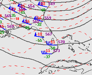
Thats a 500mb level map of Florida. The 573 at Miami means the 500mb level (how far up in the atmosphere is the air pressure 500mb) is 5730 meters (add a zero to 573).
The lines are similar to isobars (pressure lines) on a surface map. An isobar on a surface map would show where areas of equal pressure are. An isohyte (often called a height contour) shows where areas of equal geopotential height is. They gray line in south florida is the "570 line". Along that line, the air pressure is 500mb 5700 meters above sea level. The line though cuba is the 576 line.
Hopefully that helps. If not, I'm sure a pro met could explain it clearer.