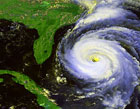
Better definable center on visible satellite imagery now with the advent of newly forming convection ...
http://www.ssd.noaa.gov/goes/flt/t2/loop-vis.html
SF
Hurricane Ernesto - Cat. 1
Moderator: S2k Moderators
-
Stormsfury

- Category 5

- Posts: 10549
- Age: 53
- Joined: Wed Feb 05, 2003 6:27 pm
- Location: Summerville, SC


gatorcane wrote:let me ask again, does anybody see the northern jog over the last few frames. Looks like NNW heading...I think it may not be over land that much at all I'm afraid.
I didn't see it before, but now I do. It looks like it jogged N for a while, but now is headed more NW. It would throw quite a wrench into the works if this thing keeps moving like this and spends very little time over Cuba.
0 likes
-
craptacular
- Category 2

- Posts: 581
- Joined: Wed Aug 02, 2006 9:17 pm
- Location: The Mad City, WI
473
UZNT13 KNHC 271906
XXAA 77194 99282 70864 08186 99016 27241 ///// 00139 26641 08003
92825 22241 36004 85556 17844 30012 70194 08838 03507 50591 06127
04508 40763 16519 07513 88999 77999
31313 09608 81845
61616 AF309 0705A ERNESTO OB 01
62626 SPL 2817N08644W 1851 LST WND 046 AEV 20604 DLM WND 35506 01
0450 WL150 07514 121 =
XXBB 77198 99282 70864 08186 00016 27241 11850 17844 22728 10630
33632 05256 44571 00322 55458 09732 66415 12124 77400 16519
21212 00016 ///// 11010 07523 22003 08010 33998 26001 44980 02008
55963 00509 66938 03003 77911 33506 88897 35002 99881 27504 11867
30012 22858 27506 33850 30012 44837 29511 55810 32011 66802 30010
77684 34511 88670 02011 99658 34007 11633 03512 22623 01015 33614
02512 44557 04525 55540 05011 66534 03511 77523 10014 88512 07513
99469 09505 11466 14010 22451 10510 33400 07513
31313 09608 81845
61616 AF309 0705A ERNESTO OB 01
62626 SPL 2817N08644W 1851 LST WND 046 AEV 20604 DLM WND 35506 01
0450 WL150 07514 121 =
;
AF309 -- different plane
0 likes


-
DROliver
Storm: Storm ERNESTO: Observed By AF #302
Storm #05 in Atlantic Ocean
Maximum Flight Level Winds Were 30KT (34.5mph) In SE Quadrant At 16:49:20 Z (Report Time: 27/1757 Z)
Max Inbound Flight Level Winds: 16.8N 73.0W 030 KT (34.5MPH) [16:49:10Z to 17:06:00Z ]
Inbound Surface Wind Observed At 30 KT (34.5MPH) @ 200°
Max Outbound Flight Level Winds: 17.8N 74.0W 024 KT (27.6MPH) [17:18:10Z to 17:49:10Z ]
Data # Position Height Temp Dewpoint Wind
I01 16.8N 73.0W Unknown data 8°C 8°C 029 KT (33.35MPH) @ 200°
I02 17.0N 73.2W Unknown data 9°C 7°C 023 KT (26.45MPH) @ 200°
I03 17.1N 73.4W Unknown data 12°C 4°C 023 KT (26.45MPH) @ 230°
I04 17.3N 73.6W Unknown data 10°C 6°C 022 KT (25.3MPH) @ 200°
I05 17.6N 73.7W Unknown data 10°C 7°C 016 KT (18.4MPH) @ 220°
O01 17.5N 74.0W Unknown data 11°C 5°C 011 KT (12.65MPH) @ 270°
O02 17.9N 74.4W Unknown data 10°C 8°C 020 KT (23MPH) @ 60°
O03 18.1N 74.6W Unknown data 9°C 8°C 016 KT (18.4MPH) @ 90°
O04 18.3N 74.8W Unknown data 8°C 8°C 017 KT (19.55MPH) @ 90°
O05 18.4N 75.0W Unknown data 8°C 8°C 017 KT (19.55MPH) @ 90°
O06 18.6N 75.2W Unknown data 8°C 8°C 020 KT (23MPH) @ 90°
0 likes

hawkeh wrote:Looks more like a TD at this point...
Well, the best looking TD I've ever seen. Latest sat pics show it getting much better organized and it's getting easier to find the center.
http://www.ssd.noaa.gov/goes/flt/t2/loop-vis.html
Last edited by Regit on Sun Aug 27, 2006 2:14 pm, edited 1 time in total.
0 likes

-
gatorcane

- S2K Supporter

- Posts: 23708
- Age: 48
- Joined: Sun Mar 13, 2005 3:54 pm
- Location: Boca Raton, FL
Regit wrote:gatorcane wrote:let me ask again, does anybody see the northern jog over the last few frames. Looks like NNW heading...I think it may not be over land that much at all I'm afraid.
I didn't see it before, but now I do. It looks like it jogged N for a while, but now is headed more NW. It would throw quite a wrench into the works if this thing keeps moving like this and spends very little time over Cuba.
Okay glad you saw it too.....it would be interesting if it emerged just north of Eastern Cuba.....
0 likes

-
gatorcane
- S2K Supporter
- Posts: 23708
- Age: 48
- Joined: Sun Mar 13, 2005 3:54 pm
- Location: Boca Raton, FL
cinlfla wrote:The center looks to still be located on the western side of the storm, if that be the case then it appears to be moving more to the north very little western movement all right now to my eyes. Not really sure if this matters to anyone I just thought I would post what I was seeing.
yes I am seeing the northern jog too and some others are seeing it -- wow it is going to get really interesting if it continue to just keep dancing to the north..
0 likes
-
craptacular
- Category 2
- Posts: 581
- Joined: Wed Aug 02, 2006 9:17 pm
- Location: The Mad City, WI
VDM before the minobs
520
URNT12 KNHC 271914
VORTEX DATA MESSAGE
A. 27/18:59:10Z
B. 17 deg 49 min N
074 deg 18 min W
C. 700 mb 3139 m
D. NA kt
E. deg nm
F. 248 deg 020 kt
G. 206 deg 057 nm
H. EXTRAP 1007 mb
I. 10 C/ 3047 m
J. 12 C/ 3047 m
K. 4 C/ NA
L. NA
M. NA
N. 1 345/ 7
O. 0.02 / 10 nm
P. AF302 0605A ERNESTO OB 12
MAX FL WIND 30 KT SE QUAD 16:49:20 Z
SLP EXTRAP FROM 700 MB
;
0 likes

gatorcane wrote:cinlfla wrote:The center looks to still be located on the western side of the storm, if that be the case then it appears to be moving more to the north very little western movement all right now to my eyes. Not really sure if this matters to anyone I just thought I would post what I was seeing.
yes I am seeing the northern jog too and some others are seeing it -- wow it is going to get really interesting if it continue to just keep dancing to the north..
I do think it has gone a little more to the west now, but if you extrapolate its current movement (judging by the last few frames) it looks like it would spend less than 12 hours over Cuba. Hardly a death knell.
0 likes

Who is online
Users browsing this forum: No registered users and 94 guests