
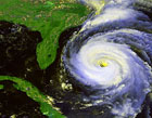
So as per Thunder44's graphic this is moving WNW and almost past Haiti?
http://img175.imageshack.us/my.php?imag ... ap2ec4.jpg
Hurricane Ernesto - Cat. 1
Moderator: S2k Moderators

Latest VORTEX shows a WESTWARD! jog still offshore of Haiti. The big blowup of convection over Haiti is apparently not where the center is (perhaps the mid-level center?).
I think perhaps Derek's assertion of mid-level shear could be right. We might be witnessing a decoupling of the low and mid level centers here.
Last edited by tallywx on Sun Aug 27, 2006 2:35 pm, edited 1 time in total.
0 likes
-
gatorcane

- S2K Supporter

- Posts: 23708
- Age: 48
- Joined: Sun Mar 13, 2005 3:54 pm
- Location: Boca Raton, FL
My feeling is that some people in Florida are temporary relieved because of Ernesto's current state and the interaction with land. But I think the story is going to change quickly once he emerged just north of Cuba and really gets its act together - we are in a temporary "lull" right now. Just my prediction.
0 likes
-
craptacular
- Category 2

- Posts: 581
- Joined: Wed Aug 02, 2006 9:17 pm
- Location: The Mad City, WI
190
SXXX50 KNHC 271934
AF302 0605A ERNESTO HDOB 30 KNHC
1919. 1753N 07305W 03045 0141 189 034 082 070 035 03233 0000000000
1920 1753N 07303W 03048 0141 183 036 084 074 037 03235 0000000000
1920. 1753N 07301W 03047 0141 182 034 068 068 036 03234 0000000000
1921 1753N 07300W 03053 0139 168 032 056 056 036 03239 0000000000
1921. 1753N 07258W 03045 0138 181 031 054 054 032 03229 0000000000
1922 1753N 07256W 03049 0140 187 031 072 072 031 03235 0000000000
1922. 1753N 07254W 03048 0142 185 031 074 074 031 03237 0000000000
1923 1753N 07252W 03047 0143 185 032 080 074 033 03236 0000000000
1923. 1753N 07250W 03049 0144 189 031 078 076 033 03239 0000000000
1924 1753N 07249W 03048 0145 188 026 076 074 027 03239 0000000000
1924. 1753N 07247W 03048 0145 187 026 076 074 026 03239 0000000000
1925 1753N 07245W 03048 0145 185 027 076 076 027 03240 0000000000
1925. 1753N 07243W 03048 0145 188 026 074 074 027 03240 0000000000
1926 1753N 07241W 03049 0146 189 024 076 074 025 03241 0000000000
1926. 1753N 07239W 03047 0146 193 026 080 070 027 03240 0000000000
1927 1753N 07237W 03048 0152 194 027 080 070 028 03246 0000000000
1927. 1751N 07237W 03015 0146 194 024 084 066 025 03208 0000000000
1928 1750N 07236W 02840 0131 183 025 092 076 026 03017 0000000000
1928. 1748N 07236W 02694 0120 168 027 096 088 029 02860 0000000000
1929 1747N 07235W 02547 0111 167 033 102 098 034 02704 0000000000
;
flying south on east side
0 likes


Been through this drill before. Took the oppurtunity today to top off my can goods and checked all my storm supplies. Good to go if Ernesto decides to make the trip across Fl through NE FL. All that's left to due is top off gas, get water and board up if necessary. Most people up here though I talked to have no idea of the latest track.
0 likes


-
Dean4Storms
- S2K Supporter
- Posts: 6358
- Age: 63
- Joined: Sun Aug 31, 2003 1:01 pm
- Location: Miramar Bch. FL
I'm paying alot more ATTENTION to the GFDL than the rest of the models right now. Remember this run from yesterday when everyone thought it was nuts? True it ends up bringing Ernesto a bit further east into the panhandle now but look at its early track and look at what we are seeing NOW. This when everyone thought a track wnw south of Jamaica was going to take place from the NHC and yours truly.
From 08-26 the 06z run
http://moe.met.fsu.edu/cgi-bin/gfdltc2. ... =Animation
GFDL run today at 12z See any consistancy?
http://moe.met.fsu.edu/cgi-bin/gfdltc2. ... =Animation
From 08-26 the 06z run
http://moe.met.fsu.edu/cgi-bin/gfdltc2. ... =Animation
GFDL run today at 12z See any consistancy?
http://moe.met.fsu.edu/cgi-bin/gfdltc2. ... =Animation
0 likes
-
miamicanes177
- Category 5

- Posts: 1131
- Joined: Tue Aug 01, 2006 10:53 pm


Remebmer...flight level is higher than normal...they are taking readins at 700MB instead of 850MB because of all of the mountians around. Winds aren't as strong up there.
They extrapolating the pressure from twice as high as normal...so the calculation is less-reliable than normal.
This is why the NHC has it at 50 knots and 1002MB...plus the pressure gradient is probably a little jumbled due to the orographic interaction.
Unfortunately things for Ernesto are not as bad as they seemed a couple of hours ago.
MW
0 likes
Updating on the twitter now: http://www.twitter.com/@watkinstrack
-
Stratosphere747
- Category 5
- Posts: 3772
- Joined: Thu Sep 11, 2003 8:34 pm
- Location: Surfside Beach/Freeport Tx
- Contact:
-
stormtruth

- Category 2
- Posts: 651
- Joined: Thu Mar 16, 2006 4:15 pm
-
craptacular
- Category 2
- Posts: 581
- Joined: Wed Aug 02, 2006 9:17 pm
- Location: The Mad City, WI
-
craptacular
- Category 2
- Posts: 581
- Joined: Wed Aug 02, 2006 9:17 pm
- Location: The Mad City, WI
dropsonde from AF309
259
UZNT13 KNHC 271945
XXAA 77194 99260 70840 08164 99016 29457 03505 00138 28056 03005
92826 22456 00505 85557 17641 02502 70193 09439 04510 50591 05746
14007 40763 15575 14008 88999 77999
31313 09608 81923
61616 AF309 0705A ERNESTO OB 02
62626 SPL 2597N08401W 1934 MBL WND 03005 AEV 20604 =
XXBB 77198 99260 70840 08164 00016 29457 11850 17641 22753 11429
33719 10456 44697 09441 55535 02141 66482 07736 77457 10158 88447
10949 99440 11558 11432 11974 22420 13561 33404 15178 44381 17961
55374 18766 66344 23564
21212 00016 03505 11850 02502 22648 05510 33474 14010 44449 11511
55369 14010 66344 12008
31313 09608 81923
61616 AF309 0705A ERNESTO OB 02
62626 SPL 2597N08401W 1934 MBL WND 03005 AEV 20604 =
;
0 likes
-
Brent
- S2K Supporter
- Posts: 38731
- Age: 37
- Joined: Sun May 16, 2004 10:30 pm
- Location: Tulsa Oklahoma
- Contact:
stormtruth wrote:Is Ernesto going around Haiti or through it?
The center appears to be just south of that SW tip according to recon, and almost past it.
http://img175.imageshack.us/my.php?imag ... ap2ec4.jpg
0 likes
#neversummer
-
Matt-hurricanewatcher


Dean4Storms wrote:I'm paying alot more ATTENTION to the GFDL than the rest of the models right now. Remember this run from yesterday when everyone thought it was nuts? True it ends up bringing Ernesto a bit further east into the panhandle now but look at its early track and look at what we are seeing NOW. This when everyone thought a track wnw south of Jamaica was going to take place from the NHC and yours truly.
From 08-26 the 06z run
http://moe.met.fsu.edu/cgi-bin/gfdltc2. ... =Animation
GFDL run today at 12z See any consistancy?
http://moe.met.fsu.edu/cgi-bin/gfdltc2. ... =Animation
Dean4storms, you beat me to the punch. I was just going to comment on the GFDL being the most consistent model with the last 3 runs nearly identical - then you brought up yesterdays 06Z and wow - I'm putting my money on this model - it was the only one that modeled KAT correctly in S FL and it seems the best on Ernie.
0 likes
Who is online
Users browsing this forum: No registered users and 177 guests