91w invest
Looks almost the same as yesterday,maybe a tad better.
Super Typhoon Chanchu - Cat. 4
Moderator: S2k Moderators
-
HurricaneHunter914
- Category 5

- Posts: 4439
- Age: 30
- Joined: Fri Mar 10, 2006 7:36 pm
- Location: College Station, TX
-
senorpepr

- Military Met/Moderator

- Posts: 12542
- Age: 41
- Joined: Fri Aug 22, 2003 9:22 pm
- Location: Mackenbach, Germany
- Contact:
While it isn't official, Typhoon2000.com is looking at 91W to possibily develop into a tropical cyclone of some sort...
Tropical Cyclone Formation is possible within the next 48 to 72 hours.
T2K Tropical Cyclone Watch [As of 11:00 AM May 07]:
Active LPA (91W/1007 mb) near 9.2N 139.7E or 1,560 km East of Surigao Del Norte
0 likes
From the JTWC Significant Tropical Weather Advisory (valid 06Z this morning)
THE AREA OF CONVECTION PREVIOUSLY LOCATED NEAR 8.9N 140.1E
IS NOW LOCATED NEAR 9.2N 139.2E, APPROXIMATELY 65 NM EAST-SOUTHEAST
OF YAP. WHILE AN EARLIER QUIKSCAT IMAGE REVEALED A BROAD, WEAK
CIRCULATION WITH MULTIPLE CIRCULATION CENTERS, RECENT ANIMATED
MULTISPECTRAL SATELLITE IMAGERY INDICATES AN INCREASE IN CONVECTION
OVER THE WESTERN END OF THIS AREA OF CYCLONIC TURNING. THE ANIMATED
IMAGERY FURTHER DEPICTS INCREASING CONVECTIVE ORGANIZATION NEAR A
POSSIBLE LOW LEVEL CIRCULATION CENTER. UPPER LEVEL ANALYSIS INDICATES
THE DISTURBANCE IS WITHIN AN ENVIRONMENT OF LOW VERTICAL WIND SHEAR
ASSOCIATED WITH DEVELOPING ANTICYCLONIC OUTFLOW. MOREOVER, SHARP
UPPER LEVEL TROUGHING TO THE WEST OF THE DISTURBANCE MAY ENHANCE
POLEWARD OUTFLOW AS THE SYSTEM TRACKS TOWARD THE NORTHWEST. MAXIMUM
SUSTAINED SURFACE WINDS ARE ESTIMATED AT 15 TO 20 KNOTS. MINIMUM SEA
LEVEL PRESSURE IS ESTIMATED TO BE NEAR 1006 MB. THE POTENTIAL FOR THE
DEVELOPMENT OF A SIGNIFICANT TROPICAL CYCLONE WITHIN THE NEXT 24 HOURS
REMAINS FAIR.
0 likes

-
Matt-hurricanewatcher

- Category 5
- Posts: 11649
- Age: 38
- Joined: Fri Nov 26, 2004 11:09 pm
- Location: Portland,OR
- Contact:
-
CHRISTY
On this IR loop you can see its become better organized!
http://www.goes.noaa.gov/guam/guamloops/guamir.html
http://www.goes.noaa.gov/guam/guamloops/guamir.html
0 likes
-
cycloneye

- Admin

- Posts: 139081
- Age: 67
- Joined: Thu Oct 10, 2002 10:54 am
- Location: San Juan, Puerto Rico
Western Pacific Panoramic View

Above s a wide view of the WPAC for those who may not know where this invest is located.It looks like it's organizing slowly however more convection has to develop near the center.
Above s a wide view of the WPAC for those who may not know where this invest is located.It looks like it's organizing slowly however more convection has to develop near the center.
0 likes
Estimates from earlier today... 1.5 from SSD and 1.0 from AFWA... the circulation has become evident in the past three hours or so on the basin ir loop
07/1433 UTC 10.4N 137.6E T1.5/1.5 91W -- West Pacific Ocean
TPPN10 KGWC 071810
A. TROPICAL DISTURBANCE NE OF PALAU
B. 07/1731Z (37)
C. 10.6N/7
D. 137.4E/5
E. SIX/MTSAT
F. T1.0/1.0/STT:S0.0/15HRS -07/1731Z-
G. IR/EIR
47A/ PBO PTLY XPSD LLCC/ ANMTN. SHEAR PATTERN
SHOWS LLCC 41NM FROM THE DG YIELDING AN
UNREALISTIC DT OF 2.5. FT BASED ON PT.
AODT: 4.3 (SHEAR)
CAMPBELL/CRUZ
0 likes
-
HurricaneHunter914
- Category 5
- Posts: 4439
- Age: 30
- Joined: Fri Mar 10, 2006 7:36 pm
- Location: College Station, TX
-
MiamiensisWx
I agree on that the circulation and center has become much more organized; however, the convection is being sheared by some increasing shear. However, I think a reburst of attempting consolidation convection may occur, especially due to better circulation organization. Slow development, especially if the shear decreases soon, is far from out of the question, in my opinion. Who agrees?
0 likes
-
MiamiensisWx
Check out the latest loop here. A very evident circulation pattern and middle-level to low-level circulation center definately is rotating to the west of the larger area of convection to the left and is moving west-northwestward. The main problem, though, is evidently shear, which is preventing convection from consolidating more. Notice how convection has attempted to develop around the circulation center but has decreased in intensity and organization around the developing LLC in the last one to two frames due to shear. However, all of the other organization and outflow signs I mentioned signal that, if shear was lower, this could easily have been developing into a tropical cyclone, and very possibly a Category Three or higher (Saffir-Simpson Scale), by now. All signs point to that, especially if it was in a more favorable environment and time of year in the western Pacific. If shear decreases a bit, also, I think slow development is very possible. Who agrees with all these points?
0 likes
-
Weatherfreak000
-
Matt-hurricanewatcher
- Category 5
- Posts: 11649
- Age: 38
- Joined: Fri Nov 26, 2004 11:09 pm
- Location: Portland,OR
- Contact:
-
CHRISTY
JTWC's latest...
THE AREA OF CONVECTION PREVIOUSLY LOCATED NEAR 9.2N
139.2E IS NOW LOCATED NEAR 8.8N 136.3E, APPROXIMATELY 110 NM
WEST-SOUTHWEST OF YAP. A 072059Z QUIKSCAT PASS REVEALED A BROAD
LOW LEVEL CIRCULATION CENTER LOCATED BETWEEN PALAU AND YAP.
HOWEVER, MULTIPLE CIRCULATION CENTERS ARE POSSIBLE BASED ON
ANALYSIS OF ANIMATED MULTISPECTRAL SATELLITE IMAGERY AND EARLIER
SATELLITE-DERIVED POSITION ESTIMATES. AT 080000Z, OBSERVATIONS
FROM PALAU AND YAP INDICATE LOW LEVEL CYCLONIC FLOW WITH SURFACE
PRESSURES NEAR 1008 MB. UPPER LEVEL ANALYSIS REVEALS THE DISTURBANCE
IS IN AN ENVIRONMENT OF LOW TO MODERATE VERTICAL WIND SHEAR WITH
ANTICYCLONIC OUTFLOW ALOFT. HOWEVER, THIS OUTFLOW IS CURRENTLY
SUPRESSED SINCE IT IS BOUNDED POLEWARD AND EQUATORWARD BY UPPER
TROPOSPHERIC TROUGHING. MAXIMUM SUSTAINED SURFACE WINDS ARE ESTIMATED
AT 15 TO 20 KNOTS. MINIMUM SEA LEVEL PRESSURE IS ESTIMATED TO BE NEAR
1006 MB. THE POTENTIAL FOR THE DEVELOPMENT OF A SIGNIFICANT TROPICAL
CYCLONE WITHIN THE NEXT 24 HOURS REMAINS FAIR.
0 likes
-
cycloneye
- Admin
- Posts: 139081
- Age: 67
- Joined: Thu Oct 10, 2002 10:54 am
- Location: San Juan, Puerto Rico
SUBJ/TROPICAL CYCLONE FORMATION ALERT 081051Z MAY 06//
WTPN21 PGTW 081100
RMKS/
1. FORMATION OF A SIGNIFICANT TROPICAL CYCLONE IS POSSIBLE WITHIN
170 NM EITHER SIDE OF A LINE FROM 8.9N 137.1E TO 9.7N 130.7E
WITHIN THE NEXT 12 TO 24 HOURS. AVAILABLE DATA DOES NOT JUSTIFY
ISSUANCE OF NUMBERED TROPICAL CYCLONE WARNINGS AT THIS TIME.
WINDS IN THE AREA ARE ESTIMATED TO BE 20 TO 25 KNOTS. METSAT IM
AGERY AT 080600Z INDICATES THAT A CIRCULATION CENTER IS LOCATED
NEAR 9.0N 136.5E. THE SYSTEM IS MOVING WESTWARD AT 07 KNOTS.
2. REMARKS:
3. THIS ALERT WILL BE REISSUED, UPGRADED TO WARNING OR CANCELLED BY 091100Z.
Tropical Storm Formation Alert Graphic
Looks better than yesterday.
0 likes
-
Weatherfreak000
-
cycloneye
- Admin
- Posts: 139081
- Age: 67
- Joined: Thu Oct 10, 2002 10:54 am
- Location: San Juan, Puerto Rico
Weatherfreak000 wrote:Wow, this thing really may have a good shot here.
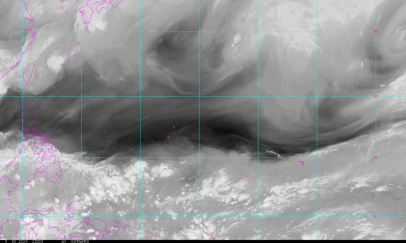
I'm kinda surprised but still skeptical, someone post a water vapor of that area?
Water Vapor Image
0 likes
Who is online
Users browsing this forum: No registered users and 106 guests