Super Typhoon Chanchu - Cat. 4

Moderator: S2k Moderators

Message
Author
CHRISTY

#21 Postby CHRISTY » Fri May 05, 2006 1:47 pm

CapeVerdeWave wrote:I never said this had a better chance, CHRISTY. Calm down. Let's not have an argument. We are ALL watching these systems!
Hey its totally cool nobody's upset capeverdewave. :wink:
0 likes   

MiamiensisWx

#22 Postby MiamiensisWx » Fri May 05, 2006 1:48 pm

Good. I just thought you were getting nervous because I wasn't posting in the eastern Pacific system thread. There is no reason to be.

:wink: :wink: :wink: :wink:
0 likes   

User avatar
James
Category 5
Category 5
Posts: 1531
Joined: Tue Aug 24, 2004 10:29 am
Location: Gloucestershire, England
Contact:

#23 Postby James » Fri May 05, 2006 1:49 pm

This system could very well do something given time. We've seen before how quickly a disorganised sytem can turn itself around.
0 likes   

CHRISTY

#24 Postby CHRISTY » Fri May 05, 2006 1:49 pm

CapeVerdeWave wrote:Good. I just thought you were getting nervous because I wasn't posting in the eastern Pacific system thread. There is no reason to be.

:wink: :wink: :wink: :wink:


no iam not nervous i think that time will come sooner rather than later for all of us in the ATLANTIC.
0 likes   

MiamiensisWx

#25 Postby MiamiensisWx » Fri May 05, 2006 1:51 pm

James wrote:This system could very well do something given time. We've seen before how quickly a disorganised sytem can turn itself around.


Exactly my sentiments based on evidence. I agree.
0 likes   

Weatherfreak000

#26 Postby Weatherfreak000 » Fri May 05, 2006 2:01 pm

This storm needs a miracle. Truly.


Infact, it's not even worth giving a chance until another day of watching it it's that bad. So forget it, maybe if it gets organizated come tomorrow, maybe.
0 likes   

CHRISTY

#27 Postby CHRISTY » Fri May 05, 2006 2:02 pm

IF ANYTHING IS GOING TO HAPPEN IT GONNA BE IN THE PACIFIC TAKE A LOOK...

Image
0 likes   

MiamiensisWx

#28 Postby MiamiensisWx » Fri May 05, 2006 2:03 pm

Weatherfreak000 wrote:This storm needs a miracle. Truly.


Infact, it's not even worth giving a chance until another day of watching it it's that bad. So forget it, maybe if it gets organizated come tomorrow, maybe.


True, it may not eventually develop much, but who's complaining if it doesn't? Not me. Also, since when did this become like the other INVESTs that DEFINATELY did not have a chance or much of it? This is different due to what I mentioned several posts back in this thread. Keep an eye on it. No, this is not wishcasting, either.

Remember, in tropical activity, things dismissed as so-called miracles DO happen. Not being insulting, but it's the truth, especially after what I've mentioned.
Last edited by MiamiensisWx on Fri May 05, 2006 2:05 pm, edited 1 time in total.
0 likes   

User avatar
Matt-hurricanewatcher
Category 5
Category 5
Posts: 11649
Age: 38
Joined: Fri Nov 26, 2004 11:09 pm
Location: Portland,OR
Contact:

#29 Postby Matt-hurricanewatcher » Fri May 05, 2006 2:04 pm

Right over that area at 11 north/115 west. Seems to be a MLC forming.
0 likes   

MiamiensisWx

#30 Postby MiamiensisWx » Fri May 05, 2006 2:06 pm

Umm... since when did this become the thread for an eastern Pacific system?

Guys, relax. Just post the eastern Pacific information in the eastern Pacific thread. Thanks.
0 likes   

MiamiensisWx

#31 Postby MiamiensisWx » Fri May 05, 2006 2:11 pm

Image

Just as I expected, a burst of convection is now occurring, including a small burst near the center. Outflow also seems to show signs of slow organization. Overall, it is definately looking a bit better now, even though pressure is up by two millibars. A rise in pressure can often occur just before or as slow organization is occurring.
0 likes   

CHRISTY

#32 Postby CHRISTY » Fri May 05, 2006 2:14 pm

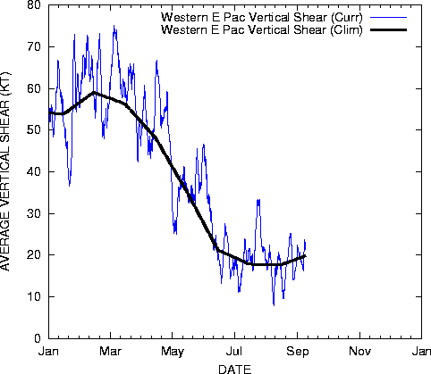
Shear will be on the decrease....

Image
0 likes   

User avatar
cycloneye
Admin
Admin
Posts: 139099
Age: 67
Joined: Thu Oct 10, 2002 10:54 am
Location: San Juan, Puerto Rico

#33 Postby cycloneye » Fri May 05, 2006 5:50 pm

Infared Image

:uarrow: :uarrow: :uarrow:

It looks like more convection has developed with this disturbance in the past few hours.
0 likes   

MiamiensisWx

#34 Postby MiamiensisWx » Fri May 05, 2006 6:01 pm

The center definately seems to be consolidating slowly with convection. Slow organization of outflow, convection, and consolidation definately appears to be taking place!

Image
0 likes   

Weatherfreak000

#35 Postby Weatherfreak000 » Fri May 05, 2006 6:05 pm

CapeVerdeWave wrote:The center definately seems to be consolidating slowly with convection. Slow organization of outflow, convection, and consolidation definately appears to be taking place!

Image


Yeah, I think now we may actually be looking at a true INVEST at least.


However, it's still nothing too special. I get the feeling if this thing doesn't start truly spinning up by tomorrow morning it's never gonna make it so i think if it's got a shot it better make it's move fast.
0 likes   

Weatherfreak000

#36 Postby Weatherfreak000 » Fri May 05, 2006 6:05 pm

CapeVerdeWave wrote:The center definately seems to be consolidating slowly with convection. Slow organization of outflow, convection, and consolidation definately appears to be taking place!

Image


Yeah, I think now we may actually be looking at a true INVEST at least.


However, it's still nothing too special. I get the feeling if this thing doesn't start truly spinning up by tomorrow morning it's never gonna make it so i think if it's got a shot it better make it's move fast.
0 likes   

User avatar
cycloneye
Admin
Admin
Posts: 139099
Age: 67
Joined: Thu Oct 10, 2002 10:54 am
Location: San Juan, Puerto Rico

#37 Postby cycloneye » Fri May 05, 2006 6:10 pm

It's the only game in town in all the tropics around the world so even if nothing occurs with it at least it's something to watch for the tropical weather trackers. :)
0 likes   
Visit the Caribbean-Central America Weather Thread where you can find at first post web cams,radars
and observations from Caribbean basin members Click Here

CHRISTY

#38 Postby CHRISTY » Fri May 05, 2006 6:13 pm

ON THIS VISIBLE LOOP U CAN CLEARLY SEE THE SPIN!

http://www.goes.noaa.gov/guam/guamloops/guamir.html
0 likes   

CHRISTY

#39 Postby CHRISTY » Fri May 05, 2006 6:15 pm

HERE IS A VISIBLE PIC.

Image
0 likes   

CHRISTY

#40 Postby CHRISTY » Fri May 05, 2006 6:36 pm

TYPHOON CENTER HAS IT LISTED AS POOR ....LOOK!

Image
0 likes   


Return to “2006”

Who is online

Users browsing this forum: No registered users and 23 guests