Tropical Storm Beryl

Moderator: S2k Moderators

Message
Author
User avatar
TheEuropean
Professional-Met
Professional-Met
Posts: 1793
Age: 58
Joined: Tue Sep 20, 2005 3:17 pm
Location: Voerde, Germany
Contact:

Tropical Storm Beryl

#1 Postby TheEuropean » Mon Jul 17, 2006 8:35 am

Here we are again:

Image

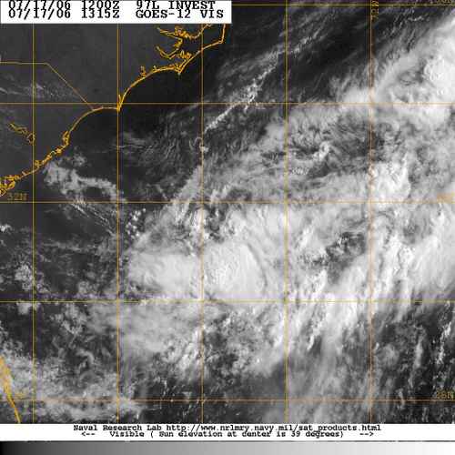
NRL: no pressure, winds 20 kt.
Last edited by TheEuropean on Tue Jul 18, 2006 9:31 am, edited 2 times in total.
0 likes   

User avatar
Thunder44
Category 5
Category 5
Posts: 5922
Age: 43
Joined: Mon Jun 09, 2003 7:53 pm
Location: New York City

#2 Postby Thunder44 » Mon Jul 17, 2006 8:36 am

946
WHXX01 KWBC 171325
CHGHUR

DISCLAIMER...NUMERICAL MODELS ARE SUBJECT TO LARGE ERRORS.
PLEASE REFER TO TPC/NHC OFFICIAL FORECASTS FOR TROPICAL CYCLONES.

NATIONAL HURRICANE CENTER NORTH ATLANTIC OBJECTIVE AIDS FOR

DISTURBANCE INVEST (AL972006) ON 20060717 1200 UTC

...00 HRS... ...12 HRS... ...24 HRS... ...36 HRS...
060717 1200 060718 0000 060718 1200 060719 0000

LAT LON LAT LON LAT LON LAT LON
BAMD 31.5N 75.4W 31.3N 75.6W 31.4N 76.0W 31.7N 76.4W
BAMM 31.5N 75.4W 31.2N 76.1W 31.2N 77.2W 31.2N 78.3W
A98E 31.5N 75.4W 31.1N 75.4W 31.4N 74.9W 31.7N 75.3W
LBAR 31.5N 75.4W 31.2N 76.1W 31.7N 77.0W 32.6N 77.8W
SHIP 20KTS 23KTS 27KTS 31KTS
DSHP 20KTS 23KTS 27KTS 31KTS

...48 HRS... ...72 HRS... ...96 HRS... ..120 HRS...
060719 1200 060720 1200 060721 1200 060722 1200

LAT LON LAT LON LAT LON LAT LON
BAMD 31.8N 76.8W 32.1N 77.3W 32.0N 77.8W 31.3N 76.6W
BAMM 31.3N 79.2W 31.1N 81.2W 31.2N 83.8W 31.2N 84.8W
A98E 31.7N 75.2W 31.2N 74.9W 31.0N 73.7W 30.9N 72.1W
LBAR 33.4N 78.3W 35.2N 78.5W 36.8N 76.7W 40.5N 69.3W
SHIP 34KTS 40KTS 42KTS 44KTS
DSHP 34KTS 40KTS 28KTS 27KTS

...INITIAL CONDITIONS...
LATCUR = 31.5N LONCUR = 75.4W DIRCUR = 190DEG SPDCUR = 4KT
LATM12 = 32.3N LONM12 = 75.2W DIRM12 = 186DEG SPDM12 = 4KT
LATM24 = 33.1N LONM24 = 75.2W
WNDCUR = 20KT RMAXWD = 40NM WNDM12 = 20KT
CENPRS = 1012MB OUTPRS = 1015MB OUTRAD = 150NM SDEPTH = D
RD34NE = 0NM RD34SE = 0NM RD34SW = 0NM RD34NW = 0NM

$$
0 likes   

User avatar
brunota2003
S2K Supporter
S2K Supporter
Posts: 9476
Age: 33
Joined: Sat Jul 30, 2005 9:56 pm
Location: Stanton, KY...formerly Havelock, NC
Contact:

#3 Postby brunota2003 » Mon Jul 17, 2006 8:36 am

yep...97L it looks better now than it did a few hours ago IMO
0 likes   

User avatar
cheezyWXguy
Category 5
Category 5
Posts: 5523
Joined: Mon Feb 13, 2006 12:29 am
Location: Dallas, TX

#4 Postby cheezyWXguy » Mon Jul 17, 2006 8:36 am

ok...nvm about me starting the thread... :lol: :lol:

thanks, European
0 likes   

User avatar
brunota2003
S2K Supporter
S2K Supporter
Posts: 9476
Age: 33
Joined: Sat Jul 30, 2005 9:56 pm
Location: Stanton, KY...formerly Havelock, NC
Contact:

#5 Postby brunota2003 » Mon Jul 17, 2006 8:38 am

:lol: Anyways, who thinks recon will go out tomorrow?
0 likes   

User avatar
cheezyWXguy
Category 5
Category 5
Posts: 5523
Joined: Mon Feb 13, 2006 12:29 am
Location: Dallas, TX

#6 Postby cheezyWXguy » Mon Jul 17, 2006 8:39 am

ME!!!!
0 likes   

User avatar
TheEuropean
Professional-Met
Professional-Met
Posts: 1793
Age: 58
Joined: Tue Sep 20, 2005 3:17 pm
Location: Voerde, Germany
Contact:

#7 Postby TheEuropean » Mon Jul 17, 2006 8:40 am

brunota2003 wrote::lol: Anyways, who thinks recon will go out tomorrow?


Here is the plan for tomorrow:

ATLANTIC REQUIREMENTS
1. NEGATIVE RECONNAISSANCE REQUIREMENTS.
2. OUTLOOK FOR SUCCEEDING DAY..POSSIBLE LOW LEVEL INVEST
AT 18/1800Z NEAR 35N 72W

First day after my holidays - now the season can start ;-)
0 likes   

User avatar
cheezyWXguy
Category 5
Category 5
Posts: 5523
Joined: Mon Feb 13, 2006 12:29 am
Location: Dallas, TX

#8 Postby cheezyWXguy » Mon Jul 17, 2006 8:41 am

dangit my computer screwed up and posted 3 times...my bad
0 likes   

User avatar
brunota2003
S2K Supporter
S2K Supporter
Posts: 9476
Age: 33
Joined: Sat Jul 30, 2005 9:56 pm
Location: Stanton, KY...formerly Havelock, NC
Contact:

#9 Postby brunota2003 » Mon Jul 17, 2006 8:45 am

TheEuropean wrote:
brunota2003 wrote::lol: Anyways, who thinks recon will go out tomorrow?


Here is the plan for tomorrow:

ATLANTIC REQUIREMENTS
1. NEGATIVE RECONNAISSANCE REQUIREMENTS.
2. OUTLOOK FOR SUCCEEDING DAY..POSSIBLE LOW LEVEL INVEST
AT 18/1800Z NEAR 35N 72W

First day after my holidays - now the season can start ;-)
:lol: Now you give it permission? can you just go on vacation for the rest of the season then and tell it not to form anything??? I can't wait to see the update to those recon plans and see if they are still scheduled to go out tomorrow plus the TWO at 11:30...will hopefully have some new info on the system...
0 likes   

User avatar
Thunder44
Category 5
Category 5
Posts: 5922
Age: 43
Joined: Mon Jun 09, 2003 7:53 pm
Location: New York City

#10 Postby Thunder44 » Mon Jul 17, 2006 8:46 am

A new recon schedule should come out this morning.
0 likes   

HurricaneHunter914
Category 5
Category 5
Posts: 4439
Age: 30
Joined: Fri Mar 10, 2006 7:36 pm
Location: College Station, TX

#11 Postby HurricaneHunter914 » Mon Jul 17, 2006 8:47 am

I'm not sure, but is it the Wet MJO causing this FAST decrease in shear. I mean yeasterday the Atlantic was full of it, now there is decreasing shear almost everywhere!

http://cimss.ssec.wisc.edu/tropic/real- ... wg8sht.GIF
0 likes   
Personal Forecast Disclaimer:
The posts in this forum are NOT official forecast and should not be used as such. They are just the opinion of the poster and may or may not be backed by sound meteorological data. They are NOT endorsed by any professional institution or storm2k.org. For official information, please refer to the NHC and NWS products.

Scorpion

#12 Postby Scorpion » Mon Jul 17, 2006 8:48 am

Wow...almost no shear over the system. Looks good for development.
0 likes   

Stormavoider
Category 2
Category 2
Posts: 671
Joined: Sat Jul 01, 2006 4:37 pm
Location: Spring Hill Fl.

#13 Postby Stormavoider » Mon Jul 17, 2006 8:53 am

It's a shame there is no pressure data from this buoy. It's real close.

http://www.ndbc.noaa.gov/station_page.php?station=41002
Last edited by Stormavoider on Mon Jul 17, 2006 8:55 am, edited 1 time in total.
0 likes   

HurricaneHunter914
Category 5
Category 5
Posts: 4439
Age: 30
Joined: Fri Mar 10, 2006 7:36 pm
Location: College Station, TX

#14 Postby HurricaneHunter914 » Mon Jul 17, 2006 8:54 am

The Atlantic is starting to cook!

Now we have 4 waves in the Atlantic; 97L, one in the Central Atlantic, one in the Western Caribbean, and a really organized one off by CapeVerde.
0 likes   
Personal Forecast Disclaimer:
The posts in this forum are NOT official forecast and should not be used as such. They are just the opinion of the poster and may or may not be backed by sound meteorological data. They are NOT endorsed by any professional institution or storm2k.org. For official information, please refer to the NHC and NWS products.

User avatar
Thunder44
Category 5
Category 5
Posts: 5922
Age: 43
Joined: Mon Jun 09, 2003 7:53 pm
Location: New York City

#15 Postby Thunder44 » Mon Jul 17, 2006 8:58 am

HurricaneHunter914 wrote:The Atlantic is starting to cook!

Now we have 4 waves in the Atlantic; 97L, one in the Central Atlantic, one in the Western Caribbean, and a really organized one off by CapeVerde.


Never amazes me how things change in just a few days. Not that every area has that good of a chance of developing though.
0 likes   

User avatar
Thunder44
Category 5
Category 5
Posts: 5922
Age: 43
Joined: Mon Jun 09, 2003 7:53 pm
Location: New York City

#16 Postby Thunder44 » Mon Jul 17, 2006 8:59 am

Stormavoider wrote:It's a shame there is no pressure data from this buoy. It's real close.

http://www.ndbc.noaa.gov/station_page.php?station=41002


I noticed that. Why doesn't this buoy have a barometer?
0 likes   

User avatar
'CaneFreak
Category 5
Category 5
Posts: 1475
Joined: Mon Jun 05, 2006 10:50 am
Location: New Bern, NC

#17 Postby 'CaneFreak » Mon Jul 17, 2006 9:02 am

That doesnt matter...look at the wind direction change....there is a weak LLC down there....hmmmm.....
0 likes   

User avatar
storms in NC
S2K Supporter
S2K Supporter
Posts: 2338
Joined: Thu Jul 28, 2005 2:58 pm
Location: Wallace,NC 40 miles NE of Wilm
Contact:

#18 Postby storms in NC » Mon Jul 17, 2006 9:03 am

Can some one tell where this low is to be? I really can't see it on the loop. Thank you
deb
0 likes   

User avatar
Nimbus
Category 5
Category 5
Posts: 4928
Joined: Mon Jul 19, 2004 10:54 am

#19 Postby Nimbus » Mon Jul 17, 2006 9:05 am

None of the invest models take this below 31N. Is there some kind of Asymptote in the modeling due too zonal steering currents?
0 likes   

User avatar
TheEuropean
Professional-Met
Professional-Met
Posts: 1793
Age: 58
Joined: Tue Sep 20, 2005 3:17 pm
Location: Voerde, Germany
Contact:

#20 Postby TheEuropean » Mon Jul 17, 2006 9:06 am

First pressure by NRL: 1012 mb
0 likes   


Return to “2006”

Who is online

Users browsing this forum: No registered users and 8 guests