Upgraded overnight to a STS, now up to 55kts. Track is a quick turn to the south followed by a good west motion.
RSMC TROPICAL CYCLONE ADVISORY
NAME STS 0613 SHANSHAN (0613)
ANALYSIS
PSTN 180900UTC 39.6N 134.3E FAIR
MOVE NNE 23KT
PRES 980HPA
MXWD 055KT
50KT 70NM
30KT 180NM
FORECAST
24HF 190900UTC 42.1N 136.6E 100NM 70%
MOVE NE 07KT
PRES 985HPA
MXWD 050KT
45HF 200600UTC 44.3N 143.2E 160NM 70%
MOVE ENE 15KT
PRES 994HPA
MXWD 040KT
69HF 210600UTC 51.9N 149.5E 290NM 70% EXTRATROPICAL LOW
NW Pacific: Typhoon Yagi (0614)
Moderator: S2k Moderators
-
WindRunner

- Category 5

- Posts: 5806
- Age: 33
- Joined: Fri Jul 29, 2005 8:07 pm
- Location: Warrenton, VA, but Albany, NY for school
- Contact:

-
Dave C
- S2K Supporter

- Posts: 868
- Joined: Thu Sep 04, 2003 4:36 pm
- Location: Middleboro, Mass.(midway between Cape Cod and Boston)
According to the JTWC Yagi is now a typhoon and moving SE at 1 knot, is that slow or what!  . Four to five days out it will be threatening Iwa Jima.
http://www.npmoc.navy.mil/jtwc/warnings/wp1606web.txt
http://www.npmoc.navy.mil/jtwc/warnings/wp1606web.txt
0 likes
-
WindRunner
- Category 5
- Posts: 5806
- Age: 33
- Joined: Fri Jul 29, 2005 8:07 pm
- Location: Warrenton, VA, but Albany, NY for school
- Contact:
HURAKAN wrote:This thread is Yagi, that's Shanshan!!!
So it is
RSMC TROPICAL CYCLONE ADVISORY
NAME STS 0614 YAGI (0614)
ANALYSIS
PSTN 181800UTC 20.3N 159.6E FAIR
MOVE SSE SLOWLY
PRES 980HPA
MXWD 055KT
50KT 50NM
30KT 160NM
FORECAST
24HF 191800UTC 20.3N 157.6E 80NM 70%
MOVE W SLOWLY
PRES 965HPA
MXWD 070KT
48HF 201800UTC 20.3N 152.3E 150NM 70%
MOVE W 12KT
PRES 955HPA
MXWD 075KT
72HF 211800UTC 22.9N 145.7E 220NM 70%
MOVE WNW 16KT
PRES 950HPA
MXWD 080KT
0 likes

-
P.K.

- Professional-Met

- Posts: 5149
- Joined: Thu Sep 23, 2004 5:57 pm
- Location: Watford, England
- Contact:
60kts, 975hPa.
RSMC TROPICAL CYCLONE ADVISORY
NAME STS 0614 YAGI (0614)
ANALYSIS
PSTN 182100UTC 20.2N 159.2E FAIR
MOVE SW SLOWLY
PRES 975HPA
MXWD 060KT
50KT 50NM
30KT 160NM
FORECAST
24HF 192100UTC 20.2N 156.4E 80NM 70%
MOVE W 06KT
PRES 960HPA
MXWD 075KT
45HF 201800UTC 20.3N 152.3E 150NM 70%
MOVE W 12KT
PRES 955HPA
MXWD 075KT
69HF 211800UTC 22.9N 145.7E 220NM 70%
MOVE WNW 16KT
PRES 950HPA
MXWD 080KT
0 likes
-
WindRunner
- Category 5
- Posts: 5806
- Age: 33
- Joined: Fri Jul 29, 2005 8:07 pm
- Location: Warrenton, VA, but Albany, NY for school
- Contact:
And we now have a typhoon. Forecast takes it very near Iwo Jima in 72 hours.
JTWC track is pointing close to Tokyo, though most likely a close recurve to the east. The JTWC track is further north than the JMA track, so a hit on the home islands cannot yet be ruled out, though Yagi is still a good week away.
RSMC TROPICAL CYCLONE ADVISORY
NAME TY 0614 YAGI (0614) UPGRADED FROM STS
ANALYSIS
PSTN 190000UTC 20.2N 159.0E GOOD
MOVE W SLOWLY
PRES 970HPA
MXWD 065KT
50KT 55NM
30KT 160NM
FORECAST
24HF 200000UTC 20.3N 155.7E 80NM 70%
MOVE W 07KT
PRES 955HPA
MXWD 075KT
48HF 210000UTC 20.4N 149.5E 150NM 70%
MOVE W 14KT
PRES 950HPA
MXWD 080KT
72HF 220000UTC 24.0N 143.2E 270NM 70%
MOVE WNW 17KT
PRES 950HPA
MXWD 080KT
0 likes
-
bostonseminole

- Tropical Storm

- Posts: 209
- Joined: Sun Sep 11, 2005 3:54 pm
- Location: Tokyo, Japan
-
bostonseminole
- Tropical Storm
- Posts: 209
- Joined: Sun Sep 11, 2005 3:54 pm
- Location: Tokyo, Japan
3Z
T0614 (YAGI)
Issued at 03:00 UTC 19 Sep 2006RSMC TROPICAL CYCLONE ADVISORY
NAME TY 0614 YAGI (0614)
ANALYSIS
PSTN 190300UTC 20.1N 158.8E GOOD
MOVE W SLOWLY
PRES 970HPA
MXWD 065KT
50KT 55NM
30KT 160NM
FORECAST
24HF 200300UTC 20.1N 155.5E 80NM 70%
MOVE W 07KT
PRES 955HPA
MXWD 075KT
45HF 210000UTC 20.4N 149.5E 150NM 70%
MOVE W 14KT
PRES 950HPA
MXWD 080KT
69HF 220000UTC 24.0N 143.2E 270NM 70%
MOVE WNW 17KT
PRES 950HPA
MXWD 080KT
0 likes
-
HurricaneBill
- Category 5
- Posts: 3420
- Joined: Sun Apr 11, 2004 5:51 pm
- Location: East Longmeadow, MA, USA
-
WindRunner
- Category 5
- Posts: 5806
- Age: 33
- Joined: Fri Jul 29, 2005 8:07 pm
- Location: Warrenton, VA, but Albany, NY for school
- Contact:
Now up to 75kts. Direct hit on Iwo Jima is indicated now at 72h.
RSMC TROPICAL CYCLONE ADVISORY
NAME TY 0614 YAGI (0614)
ANALYSIS
PSTN 190900UTC 20.1N 158.3E GOOD
MOVE W SLOWLY
PRES 960HPA
MXWD 075KT
50KT 70NM
30KT 160NM
FORECAST
24HF 200900UTC 19.4N 154.1E 80NM 70%
MOVE W 10KT
PRES 945HPA
MXWD 085KT
45HF 210600UTC 20.2N 149.2E 150NM 70%
MOVE W 14KT
PRES 940HPA
MXWD 090KT
69HF 220600UTC 24.3N 143.0E 270NM 70%
MOVE WNW 17KT
PRES 940HPA
MXWD 090KT
0 likes
-
Dave C
- S2K Supporter
- Posts: 868
- Joined: Thu Sep 04, 2003 4:36 pm
- Location: Middleboro, Mass.(midway between Cape Cod and Boston)
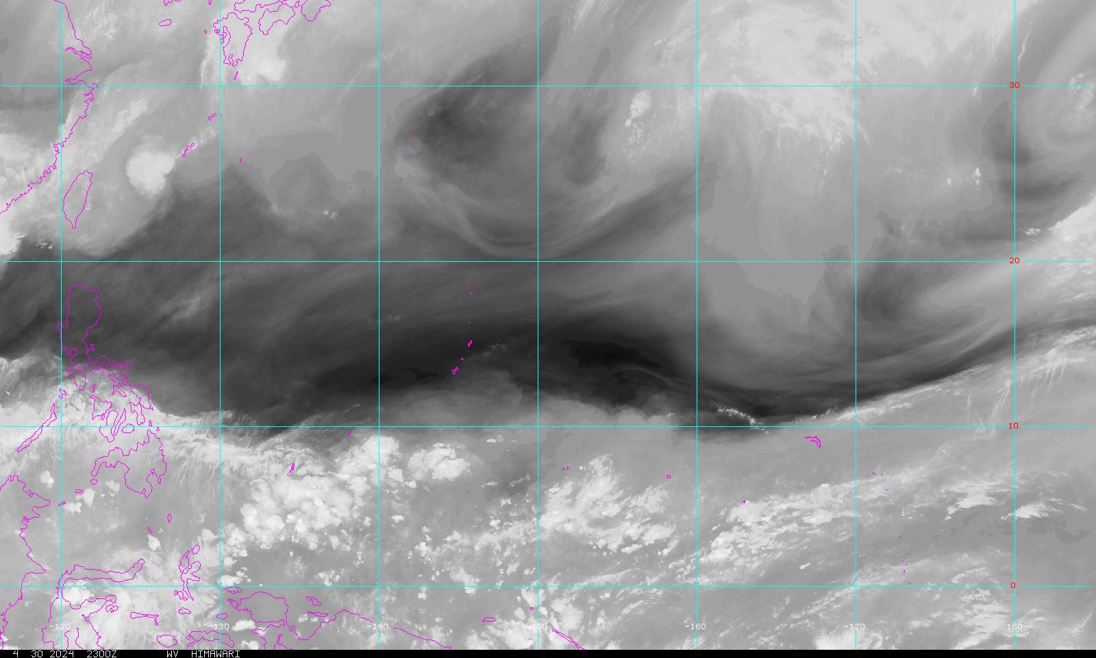
Yagi has duel outflow channels from upper-lows to it's southeast and to it's west. Dry air entrainment may hinder the intensifacation somewhat but will be interesting to watch these factors over the next few days.
http://www.goes.noaa.gov/guam/GUAMWV.JPG
http://www.goes.noaa.gov/guam/GUAMWV.JPG
Last edited by Dave C on Tue Sep 19, 2006 4:14 pm, edited 1 time in total.
0 likes
-
Dave C
- S2K Supporter
- Posts: 868
- Joined: Thu Sep 04, 2003 4:36 pm
- Location: Middleboro, Mass.(midway between Cape Cod and Boston)
Yagi is up to 100 knots now and Hurricane Bills post above mine shows a nice symetric system. JTWC peaks storm at 115 knots then begins weakening it as it approaches the Bonin Islands.
http://www.npmoc.navy.mil/jtwc/warnings/wp1606.gif
http://www.npmoc.navy.mil/jtwc/warnings/wp1606.gif
0 likes
-
WindRunner
- Category 5
- Posts: 5806
- Age: 33
- Joined: Fri Jul 29, 2005 8:07 pm
- Location: Warrenton, VA, but Albany, NY for school
- Contact:
Up to 85kts.
RSMC TROPICAL CYCLONE ADVISORY
NAME TY 0614 YAGI (0614)
ANALYSIS
PSTN 191800UTC 19.8N 156.8E GOOD
MOVE W 09KT
PRES 950HPA
MXWD 085KT
50KT 80NM
30KT 170NM
FORECAST
24HF 201800UTC 19.1N 150.3E 80NM 70%
MOVE W 15KT
PRES 940HPA
MXWD 090KT
48HF 211800UTC 21.1N 144.7E 150NM 70%
MOVE WNW 14KT
PRES 940HPA
MXWD 090KT
72HF 221800UTC 26.1N 140.7E 270NM 70%
MOVE NW 15KT
PRES 940HPA
MXWD 090KT
0 likes
-
WindRunner
- Category 5
- Posts: 5806
- Age: 33
- Joined: Fri Jul 29, 2005 8:07 pm
- Location: Warrenton, VA, but Albany, NY for school
- Contact:
Still strengthening, 90kts now with further intensification expected.
RSMC TROPICAL CYCLONE ADVISORY
NAME TY 0614 YAGI (0614)
ANALYSIS
PSTN 200300UTC 19.7N 154.8E GOOD
MOVE W 14KT
PRES 940HPA
MXWD 090KT
50KT 80NM
30KT 170NM
FORECAST
24HF 210300UTC 19.6N 148.4E 80NM 70%
MOVE W 15KT
PRES 930HPA
MXWD 095KT
45HF 220000UTC 21.6N 144.0E 150NM 70%
MOVE WNW 14KT
PRES 930HPA
MXWD 095KT
69HF 230000UTC 26.9N 140.4E 270NM 70%
MOVE NW 14KT
PRES 940HPA
MXWD 090KT
0 likes
-
whereverwx
- Category 5
- Posts: 1109
- Joined: Mon May 31, 2004 10:15 pm

-
WindRunner
- Category 5
- Posts: 5806
- Age: 33
- Joined: Fri Jul 29, 2005 8:07 pm
- Location: Warrenton, VA, but Albany, NY for school
- Contact:
RSMC TROPICAL CYCLONE ADVISORY
NAME TY 0614 YAGI (0614)
ANALYSIS
PSTN 200900UTC 19.6N 153.3E GOOD
MOVE W 14KT
PRES 940HPA
MXWD 090KT
50KT 80NM
30KT 170NM
FORECAST
24HF 210900UTC 20.5N 146.6E 80NM 70%
MOVE W 15KT
PRES 930HPA
MXWD 095KT
45HF 220600UTC 23.2N 142.3E 150NM 70%
MOVE WNW 15KT
PRES 930HPA
MXWD 095KT
69HF 230600UTC 27.6N 140.2E 220NM 70%
MOVE NNW 11KT
PRES 940HPA
MXWD 090KT
0 likes
-
WindRunner
- Category 5
- Posts: 5806
- Age: 33
- Joined: Fri Jul 29, 2005 8:07 pm
- Location: Warrenton, VA, but Albany, NY for school
- Contact:
Recurve east of Japan is now in the forecast, though Iwo Jima still looks to be getting a direct hit from Yagi.
RSMC TROPICAL CYCLONE ADVISORY
NAME TY 0614 YAGI (0614)
ANALYSIS
PSTN 201800UTC 19.6N 150.8E GOOD
MOVE W 16KT
PRES 940HPA
MXWD 090KT
50KT 80NM
30KT 170NM
FORECAST
24HF 211800UTC 21.6N 145.0E 80NM 70%
MOVE WNW 14KT
PRES 930HPA
MXWD 095KT
48HF 221800UTC 25.4N 141.2E 150NM 70%
MOVE NW 12KT
PRES 930HPA
MXWD 095KT
72HF 231800UTC 31.0N 143.8E 290NM 70%
MOVE NNE 15KT
PRES 945HPA
MXWD 085KT
0 likes
-
WindRunner
- Category 5
- Posts: 5806
- Age: 33
- Joined: Fri Jul 29, 2005 8:07 pm
- Location: Warrenton, VA, but Albany, NY for school
- Contact:
Up to 95kts with strengthening to 100kts expected as it approaches or hits Iwo Jima.
RSMC TROPICAL CYCLONE ADVISORY
NAME TY 0614 YAGI (0614)
ANALYSIS
PSTN 210900UTC 21.1N 147.0E GOOD
MOVE WNW 14KT
PRES 930HPA
MXWD 095KT
50KT 80NM
30KT 170NM
FORECAST
24HF 220900UTC 24.5N 141.9E 80NM 70%
MOVE WNW 14KT
PRES 920HPA
MXWD 100KT
45HF 230600UTC 28.1N 140.8E 150NM 70%
MOVE NNW 11KT
PRES 930HPA
MXWD 095KT
69HF 240600UTC 34.2N 145.0E 290NM 70%
MOVE NNE 17KT
PRES 950HPA
MXWD 080KT
0 likes
-
WindRunner
- Category 5
- Posts: 5806
- Age: 33
- Joined: Fri Jul 29, 2005 8:07 pm
- Location: Warrenton, VA, but Albany, NY for school
- Contact:

Who is online
Users browsing this forum: No registered users and 48 guests